Unity Lake State Recreation Site

Last updated
Unity Lake State Recreation Site
Burnt River dam.jpg
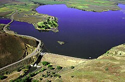
Unity Dam and Unity Reservoir
USA Oregon location map.svg
Red pog.svg
Usa edcp location map.svg
Red pog.svg
TypePublic, state
Location Baker County, Oregon
Nearest city Baker City
Coordinates 44°29′56″N118°11′14″W / 44.4988889°N 118.1872222°W / 44.4988889; -118.1872222 Coordinates: 44°29′56″N118°11′14″W / 44.4988889°N 118.1872222°W / 44.4988889; -118.1872222 [1]
Operated by Oregon Parks and Recreation Department

Unity Lake State Recreation Site is a state park in the U.S. state of Oregon, administered by the Oregon Parks and Recreation Department.

Contents

Unity Dam was constructed in 1938 by the United States Bureau of Reclamation as an irrigation storage project. The 82-foot (25 m) earthen dam impounds the water of the Burnt River to create Unity Reservoir, originally with 27,000 acre-feet (33,000,000 m3) of capacity. [2] No hydroelectric power is generated here. The project is owned by the Bureau, and operated and maintained by the local Burnt River Irrigation District.

Facilities at the adjacent state park include cabins, camp sites, day-use parking and boat ramps. [3]

See also

Related Research Articles

Snake River Major river in the northwestern United States

The Snake River is a major river of the greater Pacific Northwest region in the United States. At 1,078 miles (1,735 km) long, it is the largest tributary of the Columbia River, in turn the largest North American river that empties into the Pacific Ocean. The Snake River rises in western Wyoming, then flows through the Snake River Plain of southern Idaho, the rugged Hells Canyon on the Oregon–Idaho border and the rolling Palouse Hills of Washington, emptying into the Columbia River at the Tri-Cities in the Columbia Basin of Eastern Washington.

Sacramento River River in Northern and Central California, United States

The Sacramento River is the principal river of Northern California in the United States and is the largest river in California. Rising in the Klamath Mountains, the river flows south for 400 miles (640 km) before reaching the Sacramento–San Joaquin River Delta and San Francisco Bay. The river drains about 26,500 square miles (69,000 km2) in 19 California counties, mostly within the fertile agricultural region bounded by the Coast Ranges and Sierra Nevada known as the Sacramento Valley, but also extending as far as the volcanic plateaus of Northeastern California. Historically, its watershed has reached as far north as south-central Oregon where the now, primarily, endorheic (closed) Goose Lake rarely experiences southerly outflow into the Pit River, the most northerly tributary of the Sacramento.

Detroit Lake Body of water

Detroit Lake is a reservoir impounded by the Detroit Dam on the North Santiam River 46 miles (74 km) southeast of Salem, Oregon, United States. The lake is adjacent to Oregon Route 22 near the city of Detroit. This mesotrophic lake stores water for use by the city of Salem and other nearby communities.

Grand Coulee Dam Dam in Grant and Okanogan counties, near Coulee Dam and Grand Coulee, Washington, US

Grand Coulee Dam is a concrete gravity dam on the Columbia River in the U.S. state of Washington, built to produce hydroelectric power and provide irrigation water. Constructed between 1933 and 1942, Grand Coulee originally had only two powerhouses. The third powerhouse ("Nat"), completed in 1974 to increase energy production, makes Grand Coulee the largest power station in the United States by nameplate-capacity at 6,809 MW.

Klamath River River in Oregon and California, United States

The Klamath River flows 257 miles (414 km) through Oregon and northern California in the United States, emptying into the Pacific Ocean. By average discharge, the Klamath is the second largest river in California after the Sacramento River. It drains an extensive watershed of almost 16,000 square miles (41,000 km2) that stretches from the arid country of south-central Oregon to the temperate rainforest of the Pacific coast. Unlike most rivers, the Klamath begins in the high desert and flows toward the mountains – carving its way through the rugged Cascade Range and Klamath Mountains before reaching the sea. The upper basin, today used for farming and ranching, once contained vast freshwater marshes that provided habitat for abundant wildlife, including millions of migratory birds. Most of the lower basin remains wild, with much of it designated wilderness. The watershed is known for this peculiar geography, and the Klamath has been called "a river upside down" by National Geographic magazine.

Treasure Valley Metropolitan area and river valley in southwestern Idaho

The Treasure Valley is a valley in the western United States, primarily in southwestern Idaho, where the Payette, Boise, Weiser, Malheur, Owyhee, and Burnt rivers drain into the Snake River. It includes all the lowland areas from Vale in rural eastern Oregon to Boise, and is the most populated area in Idaho.

New Melones Dam Dam in California

New Melones Dam is an earth and rock filled embankment dam on the Stanislaus River, about 5 miles (8.0 km) west of Jamestown, California, United States, on the border of Calaveras County and Tuolumne County. The water impounded by the 625-foot (191 m)-tall dam forms New Melones Lake, California's fourth largest reservoir, in the foothills of the Sierra Nevada east of the San Joaquin Valley. The dam serves mainly for irrigation water supply, and also provides hydropower generation, flood control, and recreation benefits.

Trinity Dam Dam in Trinity County, California

Trinity Dam is an earthfill dam on the Trinity River located about 7 miles (11 km) northeast of Weaverville, California in the United States. The dam was completed in the early 1960s as part of the federal Central Valley Project to provide irrigation water to the arid San Joaquin Valley.

Millerton Lake Reservoir in Fresno and Madera counties, California

Millerton Lake is an artificial lake near the town of Friant about 15 mi (24 km) north of downtown Fresno. The reservoir was created by the construction of 319 ft high Friant Dam on the San Joaquin River which, with the lake, serves as much of the county line between Fresno County to the south and Madera County to the north.

Buffalo Bill State Park State Park in Park County, Wyoming

Buffalo Bill State Park is a public recreation area surrounding the reservoir formed by the Buffalo Bill Dam, an impoundment of the Shoshone River, in Park County, Wyoming. The state park, reservoir and dam were named after William "Buffalo Bill" Cody, who founded the nearby town of Cody and who owned much of the land now occupied by the reservoir and park. The park offers camping, hiking, boating, fishing, and picnicking and is managed by Wyoming Division of State Parks and Historic Sites.

Cochiti Dam Dam in New Mexico, USA

The Cochiti Dam is an earthen fill dam located on the Rio Grande in Sandoval County, New Mexico, approximately 50 miles (80 km) north of Albuquerque, New Mexico, in the United States. By volume of material, it is the 23rd largest dam in the world at 62,849,000 yd3 of material, one of the ten largest such dams in the United States, and the eleventh largest such dam in the world. Cochiti Dam is one of the four United States Army Corps of Engineers projects for flood and sediment control on the Rio Grande system, operating in conjunction with Abiquiu Dam, Galisteo Dam and Jemez Canyon Dam.

Folsom Dam Dam in Folsom, California

Folsom Dam is a concrete gravity dam on the American River of Northern California in the United States, about 25 mi (40 km) northeast of Sacramento. The dam is 340 ft (100 m) high and 1,400 ft (430 m) long, flanked by earthen wing dams. It was completed in 1955, and officially opened the following year.

Wallowa Lake Body of water

Wallowa Lake is a ribbon lake 1 mile (1.6 km) south of Joseph, Oregon, United States, at an elevation of 4,372 ft (1,333 m). Impounded by high moraines, it was formed by a series of Pleistocene glaciers. On the south end of the lake is a small community made up of vacation homes, lodging, restaurants, as well as other small businesses. Wallowa Lake has been used for recreation since at least 1880. The Wallowa Lake State Park is at the southern tip of the lake.

Owyhee Reservoir Body of water

Owyhee Reservoir or Owyhee Lake is a reservoir on the Owyhee River in Malheur County, Oregon, United States. Located in far Eastern Oregon near the Idaho border, the reservoir is Oregon's longest at 52 miles (84 km). The 13,900-acre (56 km2) lake is home to several species of fish, including crappie, rainbow trout, largemouth bass, smallmouth bass, yellow perch, and brown bullhead. An artificial lake, it was created in 1932 with the completion of the Owyhee Dam. The lake supplies water for irrigation for 1,800 farms covering 118,000 acres of land in Eastern Oregon and Southwestern Idaho. Seasonal Lake Owyhee State Park is located on the northeast shore and includes a boat ramp.

Emigrant Lake (Oregon) Reservoir near Ashland, Oregon, US

Emigrant Lake is a reservoir located 5 miles (8 km) southeast of Ashland, Oregon, at the southern end of the Rogue Valley. It has an elevation of 2,241 feet (683 m) above sea level. The lake has an average surface area of 806 acres (3.26 km2), and an average volume of 40,530 acre-feet (49,990,000 m3). The lake is impounded by Emigrant Lake Dam, which stands 205 feet (62 m) above the surrounding farmland, and is located on Emigrant Creek at the west side of the lake. The spillway is at the northern tip of the lake. Emigrant Creek is a tributary of Bear Creek.

Owyhee Dam Dam in Malheur County, Oregon

Owyhee Dam is a concrete arch-gravity dam on the Owyhee River in Eastern Oregon near Adrian, Oregon, United States. Completed in 1932 during the Great Depression, the dam generates electricity and provides irrigation water for several irrigation districts in Oregon and neighboring Idaho. At the time of completion, it was the tallest dam of its type in the world. The dam is part of the Owyhee Dam Historic District, which is listed on the National Register of Historic Places.

Prineville Reservoir Body of water

The Prineville Reservoir is in the high desert hills of Central Oregon, Oregon, United States. The reservoir is on the Crooked River 14 miles (22.5 km) southeast of Prineville, and 29 miles (46.7 km) east of Bend. This reservoir is a popular retreat for most of Central Oregon. It is near the geographic center of Oregon. Prineville Reservoir State Park is managed by the Oregon Parks and Recreation Department.

Whiskeytown Dam Dam in California, United States

Whiskeytown Dam is an earthfill dam on Clear Creek, a tributary of the Sacramento River of northern California in the United States.

Bonny Dam Dam in Yuma County, Colorado, US

Bonny Dam is a dam in Yuma County, Colorado, in the eastern part of the state.

References

  1. "Unity Lake State Recreation Site". Geographic Names Information System . United States Geological Survey . Retrieved 2011-06-21.
  2. "HTTP Status 500 - Unable to compile class for JSP". usbr.gov. Retrieved 2017-03-31.
  3. "Archived copy" (PDF). Archived from the original (PDF) on 2012-08-13. Retrieved 2012-07-18.{{cite web}}: CS1 maint: archived copy as title (link)