Lower Klamath National Wildlife Refuge

Last updated

Lower Klamath National Wildlife Refuge
IUCN category IV (habitat/species management area)
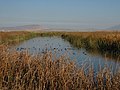
Lower Klamath National Wildlife Refuge, January 2022-2001.jpg
Winter scene at Lower Klamath NWR
Usa edcp relief location map.png
Red pog.svg
Location Siskiyou County, California / Klamath County, Oregon, United States
Nearest city Klamath Falls, OR
Coordinates 41°56′56″N121°41′48″W / 41.9487624°N 121.6966630°W / 41.9487624; -121.6966630 [1]
Area50,913 acres (206.04 km2) [2]
Established1908
Governing body United States Fish and Wildlife Service
Website Lower Klamath NWR
Reference no.66000238 [3]
DesignatedJanuary 12, 1965 [3]

The Lower Klamath National Wildlife Refuge is a National Wildlife Refuge of the United States on the border between California and Oregon. It is operated by the United States Fish and Wildlife Service. The refuge was designated a National Historic Landmark on October 16, 1965. [3]

Contents

Lower Klamath National Wildlife Refuge, established by President Theodore Roosevelt in 1908, was the first waterfowl refuge in the United States. It is located in the Klamath Basin near Klamath Falls, Oregon. It has a total area of 50,912.68 acres (206.04 km2), of which 44,294.55 acres (179.25 km2) are in California and 6,618.13 acres (26.78 km2) are in Oregon. [2] The refuge includes shallow freshwater marshes, open water, grassy uplands, and croplands that are intensively managed to provide foraging and breeding habitat for waterfowl and other animals. The market hunting of migratory birds in the late 19th century created the need for preservation and creation of a wildlife refuge. [4]

Refuge objectives include the protection of habitat for flora and fauna, including migrating waterfowl, and preserving the biodiversity of the Klamath Basin. It works to integrate wetlands and sustainable agriculture and promote integrated pest management. The refuge provides wildlife-related public services, including education, hunting, and viewing and photography opportunities.

Avian species on the refuge include the bald eagle, golden eagle, American white pelican, white-faced ibis, snow goose, Ross's goose, greater white-fronted goose, Canada goose, peregrine falcon, northern pintail, mallard, gadwall, canvasback, western grebe, eared grebe, black tern, and tricolored blackbird.

Conservation and management activities include the maintenance of a local water infrastructure and the monitoring of the interaction between agriculture and habitat. Issues in focus include the loss of wetland habitat, the degradation of water quality, drought, and water rights.

See also

Related Research Articles

<span class="mw-page-title-main">Shiawassee National Wildlife Refuge</span>

The Shiawassee National Wildlife Refuge is a 9,870.35 acres (39.9439 km2) National Wildlife Refuge in Saginaw County managed by the United States Fish and Wildlife Service. It is located in the central portion of the lower peninsula of the U.S. state of Michigan, approximately 25 miles (40 km) south of the Saginaw Bay in Lake Huron and five miles (8 km) south of the city of Saginaw in the county's Spaulding and James townships. It was established in 1953 to provide habitat for migratory waterfowl.

<span class="mw-page-title-main">Loxahatchee National Wildlife Refuge</span> United States National Wildlife Refuge in Florida

The Arthur R. Marshall Loxahatchee National Wildlife Refuge is a 145,188-acre (587.55 km2) wildlife sanctuary is located west of Boynton Beach, in Palm Beach County, Florida. It is also known as Water Conservation Area 1 (WCA-1). It includes the most northern remnant of the historic Everglades wetland ecosystem.

<span class="mw-page-title-main">Browns Park National Wildlife Refuge</span>

Browns Park National Wildlife Refuge is a 13,450-acre (5,440 ha) U.S. National Wildlife Refuge located in northwestern Colorado. It is located in Moffat County in the extreme northwestern corner of the state, in an isolated mountain valley of Browns Park on both sides of the Green River, approximately 25 miles (40 km) below Flaming Gorge Dam. Established in 1965, the refuge is managed by the United States Fish and Wildlife Service office in Maybell, Colorado. The refuge is approximately 53 miles (85 km) northwest of Maybell on State Highway 318. The refuge consists of bottomland and adjacent benchland. The western border of the refuge is the Colorado-Utah state line. The refuge is surrounded by adjacent lines of the Bureau of Land Management. The refuge contains the site of the former Fort Davy Crockett that was constructed in 1837 to protect trappers against attacks by Blackfoot Native Americans.

<span class="mw-page-title-main">Klamath Basin National Wildlife Refuge Complex</span>

The Klamath Basin National Wildlife Refuge Complex is a wildlife preserve operated by the United States Fish and Wildlife Service in the Klamath Basin of southern Oregon and northern California near Klamath Falls, Oregon. It consists of Bear Valley, Klamath Marsh and Upper Klamath National Wildlife Refuge (NWR) in southern Oregon and Lower Klamath, Tule Lake, and Clear Lake NWR in northern California.

<span class="mw-page-title-main">Tule Lake National Wildlife Refuge</span> Wildlife refuge in northern California, United States

The Tule Lake National Wildlife Refuge is a National Wildlife Refuge of the United States in northern California near the Oregon border. It covers 39,116 acres (15,830 ha) in the Tule Lake basin. It is part of the Klamath Basin National Wildlife Refuge Complex, and is a crucial part of the Pacific Flyway corridor for migratory birds.

<span class="mw-page-title-main">Malheur National Wildlife Refuge</span>

Malheur National Wildlife Refuge is a National Wildlife Refuge located roughly 30 miles (48 km) south of the city of Burns in Oregon's Harney Basin. Administered by the United States Fish and Wildlife Service, the refuge area is roughly T-shaped with the southernmost base at Frenchglen, the northeast section at Malheur Lake and the northwest section at Harney Lake.

<span class="mw-page-title-main">Ankeny National Wildlife Refuge</span>

Ankeny National Wildlife Refuge is located in the fertile Willamette Valley of northwestern Oregon, 12 miles (19 km) south of Salem. The valley was once a rich mix of wildlife habitats. Valley wetlands were once extensive, with meandering stream channels and vast seasonal marshes. Today, the valley is a mix of farmland and growing cities, with few areas remaining for wildlife.

<span class="mw-page-title-main">Baskett Slough National Wildlife Refuge</span>

Baskett Slough National Wildlife Refuge is in northwestern Oregon, 10 miles (16 km) west of Salem in Polk County. The Refuge consists of 1,173 acres (4.75 km²) of cropland, which provide forage for wintering geese, 300 acres (1.2 km²) of forests, 550 acres (2.2 km²) of grasslands, and 500 acres (2.0 km²) of shallow water seasonal wetlands and 35 acres (0.14 km²) of permanent open water. In 1965, Baskett Slough National Wildlife Refuge was created to help ensure some of the original habitat remained for species preservation. The refuge is managed by the U.S. Fish and Wildlife Service, an agency of the U.S. Department of the Interior.

<span class="mw-page-title-main">Wood River (Oregon)</span> River in Oregon, United States

The Wood River is a short river in the southern region of the U.S. state of Oregon, and part of the Klamath Basin drainage. It flows 18 miles (29 km) through the Fremont-Winema National Forests, Bureau of Land Management land, and private property in southern Oregon. Its watershed consists of 220 square miles (570 km2) of conifer forest, rural pasture land, and marsh. The river provides habitat for many species of wildlife including an adfluvial (migratory) and resident populations of native Great Basin redband trout.

<span class="mw-page-title-main">Eastern Cascades Slopes and Foothills</span> Temperate coniferous forests ecoregion of the United States

The Eastern Cascades Slopes and Foothills ecoregion is a Level III ecoregion designated by the United States Environmental Protection Agency (EPA) in the U.S. states of Oregon, Washington, and California. In the rain shadow of the Cascade Range, the eastern side of the mountains experiences greater temperature extremes and receives less precipitation than the west side. Open forests of ponderosa pine and some lodgepole pine distinguish this region from the Cascades ecoregion, where hemlock and fir forests are more common, and from the lower, drier ecoregions to the east, where shrubs and grasslands are predominant. The vegetation is adapted to the prevailing dry, continental climate and frequent wildfire. Volcanic cones and buttes are common in much of the region.

<span class="mw-page-title-main">Lacassine National Wildlife Refuge</span> Wildlife refuge in Louisiana

Lacassine National Wildlife Refuge is located in Cameron and Evangeline Parishes in southwestern Louisiana, was established in 1937 by Executive Order No. 7780 as "a refuge and breeding ground for migratory birds and other wildlife." The refuge is nearly 35,000 acres (140 km2) in size, including 653 acres (2.64 km2) leased from the Cameron Parish School Board. The Evangeline Parish unit is called Duralde Prairie and is currently being developed. It is located south of the city of Eunice.

The San Luis National Wildlife Refuge Complex is located in the northern San Joaquin Valley, within Merced County and Stanislaus County of California. The complex, with four federal National Wildlife Refuges, is managed by the U.S Fish & Wildlife Service.

<span class="mw-page-title-main">Clear Lake National Wildlife Refuge</span> National Wildlife Refuge of the United States in northeastern California

Clear Lake National Wildlife Refuge is a National Wildlife Refuge of the United States in northeastern California. It includes about 20,000 acres (81 km2) of open water surrounded by over 26,000 acres (110 km2) of upland bunchgrass, low sagebrush, and juniper habitat. small, rocky islands in the wetlands provide breeding sites for American white pelicans, double-crested cormorants, and other colony-nesting birds.

<span class="mw-page-title-main">Hart Lake (Oregon)</span> Lake of the United States of America

Hart Lake is a shallow lake in the Warner Valley of eastern Lake County, Oregon, United States. The lake covers 7,324 acres (29.64 km2) and has the most stable water level within the valley's Warner Lakes chain. The lake is named for the heart-shaped brand used by the pioneer Wilson and Alexander cattle ranch established near the lake. Much of the land around Hart Lake is administered by the Bureau of Land Management (BLM) and the United States Fish and Wildlife Service (FWS). The lake and the surrounding wetlands support a wide variety of birds and other wildlife. Recreational opportunities on and near Hart Lake include hunting, fishing, bird watching, and boating.

<span class="mw-page-title-main">Umatilla National Wildlife Refuge</span> Protected area in Oregon and Washington, US

The Umatilla National Wildlife Refuge is located on and around the Columbia River about 15 miles (24 km) northwest of Hermiston, Oregon and includes 8,907 acres (3,605 ha) in Oregon, and 14,876 acres (6,020 ha) in Washington. It was established in 1969 to help mitigate habitat lose due to the flooding that occurred following the construction of the John Day Dam. The refuge is popular with birdwatchers and wildlife enthusiasts.

<span class="mw-page-title-main">Cold Springs National Wildlife Refuge</span> Protected area in Oregon, United States

Cold Springs National Wildlife Refuge is a 3,117-acre (12.61 km2) National Wildlife Refuge located 7 miles (10 km) northeast of Hermiston and 3 miles (5 km) south of the Columbia River in Umatilla County, Oregon; The refuge was established in 1909 as a preserve and breeding ground for native birds. It consists of diverse wetland habitats surrounded by upland habitat of big sagebrush and native steppe grasses. A riparian component of willow and cottonwood provides refuge for birds, mammals, and other animals.

Maple River National Wildlife Refuge is a National Wildlife Refuge in North Dakota. It is managed under Kulm Wetland Management District.

<span class="mw-page-title-main">Modoc National Wildlife Refuge</span> National Wildlife Refuge in the United States

Modoc National Wildlife Refuge is a National Wildlife Refuge of the United States located in northeastern California. It is next to the South Fork of the Pit River in Modoc County, southeast of Alturas.

<span class="mw-page-title-main">Ana River</span> River in Oregon, United States of America

The Ana River is a short spring-fed river in south-central Oregon. It is on the northwestern edge of the Great Basin drainage. It flows 7 miles (11 km) from springs at the foot of Winter Ridge through high desert, range, and wetlands before emptying into Summer Lake. For most of its course, the Ana River flows through the Summer Lake Wildlife Area, which is maintained by the Oregon Department of Fish and Wildlife. The river provides habitat for many mammal and bird species, as well as several fish species, including the rare Summer Lake Tui chub. The largest hybrid striped bass ever caught in Oregon was taken from Ana Reservoir in 2009.

<span class="mw-page-title-main">Summer Lake Wildlife Area</span> Wildlife refuge in Oregon

The Summer Lake Wildlife Area is a 29.6-square-mile (77 km2) wildlife refuge located on the northwestern edge of the Great Basin drainage in south-central Oregon. It is administered by the Oregon Department of Fish and Wildlife. The refuge is an important stop for waterfowl traveling along the Pacific Flyway during their spring and fall migrations. The Summer Lake Wildlife Area also provides habitat for shorebirds and other bird species as well as wide variety of mammals and several fish species. The Ana River supplies the water for the refuge wetlands.

References

PD-icon.svg This article incorporates public domain material from websites or documents of the United States Fish and Wildlife Service .

  1. "Lower Klamath National Wildlife Refuge". Geographic Names Information System . United States Geological Survey, United States Department of the Interior . Retrieved August 21, 2011.
  2. 1 2 "Annual Report of Lands as of September 30, 2009" (PDF). United States Fish and Wildlife Service.
  3. 1 2 3 "Lower Klamath National Wildlife Refuge". National Historic Landmark summary listing. National Park Service. Archived from the original on November 14, 2007. Retrieved July 5, 2008.
  4. Huston, Anne E.; Huston, Anne E. (1999). a River Never the Same. Klamath Falls, OR: Shaw Historical Library. pp. 59–60. ISBN   0-9667919-1-6.