Missisquoi National Wildlife Refuge is a National Wildlife Refuge located in the eastern shore of Lake Champlain in the U.S. state of Vermont. The refuge is in Franklin County in the northwest corner of the state near the International Boundary with Canada. It is the only National Wildlife Refuge located entirely in Vermont, and is administered by the United States Fish and Wildlife Service.
The Klamath Basin National Wildlife Refuge Complex is a wildlife preserve operated by the United States Fish and Wildlife Service in the Klamath Basin of southern Oregon and northern California near Klamath Falls, Oregon. It consists of Bear Valley, Klamath Marsh and Upper Klamath National Wildlife Refuge (NWR) in southern Oregon and Lower Klamath, Tule Lake, and Clear Lake NWR in northern California.

The Erie National Wildlife Refuge is an 8,777-acre (3,552 ha) National Wildlife Refuge located in Crawford County, Pennsylvania. Named after the Erie tribe, it was established to provide waterfowl and other migratory birds with nesting, feeding, brooding, and resting habitat.

Ankeny National Wildlife Refuge is located in the fertile Willamette Valley of northwestern Oregon, 12 miles (19 km) south of Salem. The valley was once a rich mix of wildlife habitats. Valley wetlands were once extensive, with meandering stream channels and vast seasonal marshes. Today, the valley is a mix of farmland and growing cities, with few areas remaining for wildlife.
Baskett Slough National Wildlife Refuge is located in northwestern Oregon, 10 miles (16 km) west of Salem in Polk County. Situated in open farmland near the eastern foothills of the Oregon Coast Range with the broad Willamette Valley and the Cascade Range to the east, elevations range from 185 to 414 feet MSL. The Willamette Valley, with its mild, rainy winter climate, is an ideal environment for wintering waterfowl. The valley was once a rich mix of wildlife habitats with extensive wetlands, meandering stream channels and vast seasonal marshes. Today, the valley is a mix of farmland and growing cities, with few areas remaining for wildlife. The Refuge consists of 1,173 acres (4.75 km²) of cropland, which provide forage for wintering geese, 300 acres (1.2 km²) of forests, 550 acres (2.2 km²) of grasslands, and 500 acres (2.0 km²) of shallow water seasonal wetlands and 35 acres (0.14 km²) of permanent open water. In 1965, Baskett Slough National Wildlife Refuge was created to help ensure some of the original habitat remained for species preservation. The refuge is managed by the U.S. Fish and Wildlife Service, an agency of the U.S. Department of the Interior.

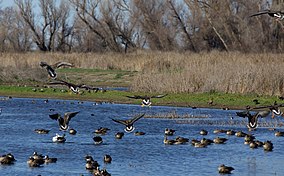
The Yolo Bypass Wildlife Area is located within the Yolo Bypass in Yolo County, California. The wildlife area is managed by the California Department of Fish and Wildlife with the intent of restoring and managing a variety of wildlife habitats in the Yolo Basin, a natural basin in the north part of the Sacramento-San Joaquin River Delta. The creation of the wildlife area was spearheaded by the Yolo Basin Foundation. The California Department of Fish and Wildlife and Yolo Basin Foundation are the core partners in the operation of this unique community resource. Located at 38.550515°N 121.626291°W
Catahoula National Wildlife Refuge, located in east central Louisiana, United States, 12 miles (19 km) east of Jena, was established in 1958 as a wintering area for migratory waterfowl. The refuge contains 25,162 acres (101.83 km2) divided into two units. The 6,671-acre (27 km2) Headquarters Unit borders nine miles (14 km) of the northeast shore of Catahoula Lake, a 26,000-acre (110 km2) natural wetland renowned for its large concentrations of migratory waterfowl. The 18,491-acre (74.83 km2) Bushley Bayou Unit, located 8 miles (13 km) west of Jonesville, was established May 16, 2001. This acquisition was made possible through a partnership agreement between The Conservation Fund, American Electric Power, and the Fish and Wildlife Service. The habitat found at the refuge is primarily lowland hardwood forest subject to seasonal backwater flooding from the Ouachita, and Red Rivers.
The San Luis National Wildlife Refuge Complex is located in the northern San Joaquin Valley, within Merced County and Stanislaus County of California. The complex, with four federal National Wildlife Refuges, is managed by the U.S Fish & Wildlife Service.

The Sonny Bono Salton Sea National Wildlife Refuge is located 40 miles (64 km) north of the Mexican border at the southern end of the Salton Sea in California's Imperial Valley. Situated along the Pacific Flyway, the Refuge is the only one of its kind, located 227 feet (69 m) below sea level. Because of its southern latitude, elevation and location in the Colorado Desert, the Refuge experiences some of the highest temperatures in the nation. Daily temperatures from May to October generally exceed 100 °F with temperatures of 116°–120 °F recorded yearly.
Sutter National Wildlife Refuge, the southern-most refuge in the Sacramento National Wildlife Refuge Complex, is located in the Sacramento Valley of California, about 50 miles (80 km) north of the metropolitan area of Sacramento. The refuge consists of about 2,600 acres (11 km2), consisting primarily of wetland impoundments with some riparian and grassland habitat.

The Stone Lakes National Wildlife Refuge, located south of Sacramento, California, lies within the Sacramento-San Joaquin delta, the destination of thousands of migrating waterfowl, shorebirds, and other water birds. The refuge was established in 1994.

The San Luis National Wildlife Refuge in the San Joaquin Valley of central California is one of the great remnants of a historically bountiful wintering grounds for migratory waterfowl on the Pacific Flyway. Located in the Bear Creek, Salt Slough, and San Joaquin River floodplain, it hosts a myriad of tree-lined channels and oxbows, wetlands and native grasslands.

The Delevan National Wildlife Refuge is one of six refuges in the Sacramento National Wildlife Refuge Complex in the Sacramento Valley of central northern California.

Pixley National Wildlife Refuge is located 35 miles (56 km) south of Tulare, California and 45 miles (72 km) north of Bakersfield in the San Joaquin Valley. The 6,939-acre (2,808 ha) nature refuge represents one of the few remaining examples of the grasslands, vernal pools, and playas that once bordered historic Tulare Lake, the largest lake west of the Great Lakes until the late 19th century.

Kern National Wildlife Refuge is a 1,249-acre (5.05 km2) protected area located in the southern portion of California's San Joaquin Valley, 20 miles west of the city of Delano. Situated on the southern margin of what was once the largest freshwater wetland complex in the western United States, Kern National Wildlife Refuge provides optimum wintering habitat for migratory birds with an emphasis on waterfowl and water birds.
The Merced National Wildlife Refuge encompasses 10,262 acres (41.53 km2) of wetlands, native grasslands, vernal pools, and riparian areas in California. It was established in 1951 under the Lea Act to attract wintering waterfowl from adjacent farmland where their foraging was causing crop damage. In the last few decades, changes in agricultural practices and refuge management have reduced these wildlife/crop issues.

Butte Sink Wildlife Management Area is located in Colusa, Butte, and Sutter Counties. It is wetlands managed as part of the Sacramento National Wildlife Refuge Complex and is not open to the public.
Willow Creek-Lurline Wildlife Management Area is located in the Sacramento Valley of California. The landscape is very flat, bordered by the Sierra and Coast ranges and surrounded by intensive agriculture. The objective of this wildlife management area is to protect fall/winter habitat for waterfowl through the acquisition of conservation easements on privately owned wetlands. It is not open to the public.
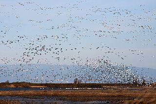
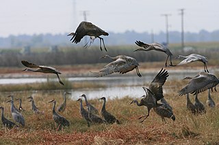
The Refuge Water Supply Program (RWSP) is administered by the United States Department of the Interior jointly by the Bureau of Reclamation and Fish and Wildlife Service and tasked with acquiring a portion and delivering a total of 555,515 acre feet (AF) of water annually to 19 specific protected wetland areas in the Central Valley of California as mandated with the passing of the Central Valley Project Improvement Act signed on October 30, 1992 by President George H. W. Bush.