| William B. Ide Adobe State Historic Park | |
|---|---|
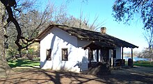 Front of the adobe in 2011 | |
 | |
| Nearest city | Red Bluff, California |
| Coordinates | 40°11′48″N122°13′31″W / 40.1968°N 122.2252°W |
| Governing body | State of California |
| Reference no. | 12 [1] |
William B. Ide Adobe State Historic Park is a California State Historic Park located on the west bank of the Sacramento River, a mile north of Red Bluff in Tehama County, California. Although it was initially believed that Ide built the adobe, research has shown that he never lived in the place that bears his name today. Nevertheless, the State of California decided to keep the name of the park in recognition of Ide's role in California history.