The Mojave River is an intermittent river in the eastern San Bernardino Mountains and the Mojave Desert in San Bernardino County, California, United States. Most of its flow is underground, while its surface channels remain dry most of the time, except for the headwaters and several bedrock gorges in the lower reaches.

Amboy Crater is a dormant cinder cone volcano that rises above a 70-square-kilometer (27 sq mi) lava field in the eastern Mojave Desert of southern California, within Mojave Trails National Monument.
The Chuckwalla Mountains are a mountain range in the transition zone between the Colorado Desert—Sonoran Desert and the Mojave Desert, climatically and vegetationally, in Riverside County of southern California.
The Clipper Mountains are located in the eastern Mojave Desert and protected within Mojave Trails National Monument, in San Bernardino County, California.
The Piute Mountains are a mountain range located in the Eastern Mojave Desert and within Mojave Trails National Monument, in San Bernardino County, California.

The Santa Rosa and San Jacinto Mountains National Monument is a National Monument in southern California. It includes portions of the Santa Rosa and San Jacinto mountain ranges, the northernmost ones of the Peninsular Ranges system. The national monument covers portions of Riverside County, west of the Coachella Valley, approximately 100 miles (160 km) southeast of downtown Los Angeles.

The Big Morongo Canyon Preserve is a 31,000-acres (130 km2) native plants habitat and wildlife preserve located in the Little San Bernardino Mountains of the Transverse Ranges, in the transition zone between the higher Mojave Desert and lower elevation Colorado Desert section of the Sonoran Desert. Due to its location within this transition zone, the area is especially high in natural diversity. The natural spring fed desert oasis found here is one of the 10 largest Cottonwood and Willow riparian habitats in California. It is also identified by the Audubon Society as one of the most important avian habitat areas in California.

The Mojave Road, also known as Old Government Road, is a historic route and present day dirt road across what is now the Mojave National Preserve in the Mojave Desert in the United States. This rough road stretched 147 miles (237 km) from Beale's Crossing, to Fork of the Road location along the north bank of the Mojave River where the old Mojave Road split off from the route of the Old Spanish Trail/Mormon Road.

The Kiavah Wilderness is a federally designated wilderness area located in the Mojave Desert, Scodie Mountains, and southern Sierra Nevada in Kern County, California, United States. California State Route 178 connects the town of Lake Isabella to State Highway 14 in the east, crossing Walker Pass at the north boundary of the wilderness.
Rasor Off-Highway Vehicle Area is a remote public use area for the off-highway vehicle user located in the Mojave Desert about 50 miles (80 km) east of Barstow, California, administered by the Bureau of Land Management.
The Piper Mountain Wilderness is a federally designated wilderness area located in the White Mountains 20 miles (32 km) northeast of Big Pine, California in Inyo County, California.
The California Desert Protection Act of 2010 was legislation proposed by U.S. Senator Dianne Feinstein. The stated aim of the legislation was "to provide for conservation, enhanced recreation opportunities, and development of renewable energy in the California Desert Conservation Area."

The Clipper Mountain Wilderness is a wilderness area in the Clipper Mountains of the eastern Mojave Desert and within Mojave Trails National Monument, located in northeastern San Bernardino County, California. It is under the jurisdiction of the Bureau of Land Management.
The Wildlands Conservancy is a nonprofit organization with a mission to preserve land for public recreation. It manages 25 preserves, detailed in the list of its preserves, covering over 200,000 acres (81,000 ha) across the western United States. The preserve system encompasses diverse landscapes including mountains, valleys, deserts, rivers, and oceanfront lands. The Wildlands Conservancy buys and restores land, builds public visitor facilities, and provides outdoor education programs for children. All usage is free of charge, attracting over 1.5 million visitors annually.

Castle Mountains National Monument is a U.S. National Monument located in the eastern Mojave Desert and northeastern San Bernardino County, in the state of California.

Sand to Snow National Monument is a U.S. National Monument located in San Bernardino County and northern Riverside County, Southern California.
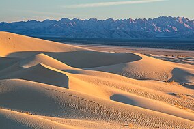
Cadiz Dunes Wilderness is a protected wilderness area in the Mojave Trails National Monument in San Bernardino County, California. Established in 1994 by the U.S. Congress, the area is managed by the Bureau of Land Management. This wilderness area is north of Joshua Tree National Park, Sheephole Valley Wilderness lies to the west, Old Woman Mountains Wilderness to the east. The dunes of Cadiz Dunes were formed by blowing sands from the Cadiz dry lake, all located in the Cadiz Valley between the Calumet Mountains and the Old Woman Mountains. The ecology is typical of the Mojave Desert with wildlife that includes coyote, black-tailed jackrabbits, ground squirrels, kangaroo rats, quail, roadrunners, and rattlesnakes. The area is known for a brilliant display of springtime desert wildflowers including the Borrego milkvetch.
Whitewater Preserve is a nature preserve owned and managed by The Wildlands Conservancy, a nonprofit land conservancy. Consisting of 2,851 acres (11.54 km2) of land in Riverside County, California, the preserve features the perennial Whitewater River flowing through a desert canyon. The preserve is located within the San Bernardino Mountains and is part of the Sand to Snow National Monument. More preserves can be found in the list of preserves.