Pipe Spring National Monument

Last updated

Pipe Spring National Monument
Pipe Spring NM01.jpg
Winsor Castle
USA Arizona relief location map.svg
Red pog.svg
Usa edcp relief location map.png
Red pog.svg
Location Mohave County, Arizona, US
Nearest city Fredonia, AZ
Coordinates 36°51′45″N112°44′15″W / 36.86250°N 112.73750°W / 36.86250; -112.73750
Area40 acres (16 ha) [1]
CreatedMay 31, 1923 (1923-May-31)
Visitors25,179(in 2018) [2]
Governing body National Park Service
Website Pipe Spring National Monument
Pipe Spring's Deseret Telegraph office, the first such office in Arizona First telegraph office in Arizona, Pipe Spring.JPG
Pipe Spring's Deseret Telegraph office, the first such office in Arizona

Pipe Spring National Monument is a United States National Monument located in the U.S. state of Arizona, rich with American Indian, early explorer, and Mormon pioneer history. Administered by the National Park Service, Pipe Spring was listed on the National Register of Historic Places on October 15, 1966, and the boundaries of the Pipe Spring National Monument Historic District (a portion of the monument) were expanded in October 2000. [3]

Contents

History

The water of Pipe Spring has made it possible for plants, animals, and people to live in this dry desert region. Ancestral Puebloans and Kaibab Paiute Indians gathered grass seeds, hunted animals, and raised crops near the springs for at least 1,000 years.

Antonio Armijo discovered the springs when he passed through the area in 1829, when he established by the Armijo Route of the Old Spanish Trail.

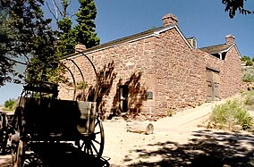
Pipe Spring was named by the 1858 Latter-day Saint missionary expedition to the Hopi mesas led by Jacob Hamblin. In the 1860s Mormon pioneers from St. George, Utah, led by James M. Whitmore brought cattle to the area, and a large cattle ranching operation was established. In 1866 the Apache, Navajo and Paiute tribes of the region joined the Utes for the Black Hawk War, and, after they raided Pipe Spring, a protective fort was constructed by 1872 over the main spring. The following year the fort and ranch was purchased by Brigham Young for the Church of Jesus Christ of Latter-day Saints (LDS Church). The LDS Bishop of nearby Grafton, Utah, Anson Perry Winsor, was hired to operate the ranch and maintain the fort, soon called Winsor Castle. This isolated outpost served as a way station for people traveling across the Arizona Strip, that part of Arizona separated from the rest of the state by the Grand Canyon. It also served as a refuge for polygamist wives during the 1880s and 1890s. The LDS Church lost ownership of the property through penalties involved in the federal Edmunds-Tucker Act of 1887.

Although their way of life was greatly impacted by Mormon settlement, the Paiute Indians continued to live in the area and by 1907 the Kaibab Paiute Indian Reservation was established, surrounding the privately owned Pipe Spring ranch. In 1923, the Pipe Spring ranch was purchased and set aside as a national monument to be a memorial to western pioneer life.

The site today

Today the Pipe Spring National Monument, Kaibab Band of Paiute Indians Visitor Center, and Museum explain the human history of the area over time. Daily tours of Winsor Castle, summer "living history" demonstrations, an orchard and garden, and a half-mile trail offer a glimpse of American Indian and pioneer life in the Old West. The Paiute tribe runs a small adjoining campground.

Climate

Pipe Spring National Monument has a semi-arid climate (Köppen: BSk) with cold winters and hot summers.

Climate data for Pipe Spring National Monument, Arizona, 1991–2020 normals, extremes 1963–present
MonthJanFebMarAprMayJunJulAugSepOctNovDecYear
Record high °F (°C)79
(26)
78
(26)
85
(29)
91
(33)
99
(37)
110
(43)
109
(43)
105
(41)
104
(40)
93
(34)
79
(26)
69
(21)
110
(43)
Mean maximum °F (°C)59.3
(15.2)
65.6
(18.7)
75.4
(24.1)
83.3
(28.5)
91.0
(32.8)
99.6
(37.6)
103.1
(39.5)
99.5
(37.5)
94.6
(34.8)
85.4
(29.7)
72.1
(22.3)
60.6
(15.9)
103.5
(39.7)
Mean daily maximum °F (°C)47.8
(8.8)
52.3
(11.3)
60.9
(16.1)
67.8
(19.9)
77.7
(25.4)
89.3
(31.8)
94.3
(34.6)
91.8
(33.2)
84.5
(29.2)
71.7
(22.1)
58.6
(14.8)
46.8
(8.2)
70.3
(21.3)
Daily mean °F (°C)35.4
(1.9)
39.2
(4.0)
45.9
(7.7)
51.9
(11.1)
61.3
(16.3)
71.4
(21.9)
77.8
(25.4)
76.0
(24.4)
68.2
(20.1)
55.9
(13.3)
44.1
(6.7)
34.5
(1.4)
55.1
(12.8)
Mean daily minimum °F (°C)23.0
(−5.0)
26.0
(−3.3)
30.8
(−0.7)
36.1
(2.3)
45.0
(7.2)
53.5
(11.9)
61.2
(16.2)
60.2
(15.7)
51.9
(11.1)
40.0
(4.4)
29.7
(−1.3)
22.3
(−5.4)
40.0
(4.4)
Mean minimum °F (°C)9.3
(−12.6)
13.1
(−10.5)
19.4
(−7.0)
24.6
(−4.1)
30.9
(−0.6)
41.0
(5.0)
51.0
(10.6)
51.1
(10.6)
39.5
(4.2)
26.9
(−2.8)
14.3
(−9.8)
7.4
(−13.7)
4.7
(−15.2)
Record low °F (°C)−12
(−24)
−8
(−22)
4
(−16)
8
(−13)
20
(−7)
33
(1)
40
(4)
38
(3)
28
(−2)
10
(−12)
0
(−18)
−13
(−25)
−13
(−25)
Average precipitation inches (mm)1.41
(36)
1.38
(35)
1.06
(27)
0.66
(17)
0.52
(13)
0.19
(4.8)
1.14
(29)
1.30
(33)
1.06
(27)
1.08
(27)
0.55
(14)
1.05
(27)
11.40
(290)
Average snowfall inches (cm)0.3
(0.76)
2.1
(5.3)
1.2
(3.0)
0.4
(1.0)
0.0
(0.0)
0.0
(0.0)
0.0
(0.0)
0.0
(0.0)
0.0
(0.0)
0.0
(0.0)
0.8
(2.0)
1.0
(2.5)
5.8
(15)
Average precipitation days (≥ 0.01 inch)5.46.24.73.33.81.65.26.84.24.42.74.552.8
Average snowy days (≥ 0.1 inch)0.71.30.60.30.00.00.00.00.00.00.31.44.6
Source: NOAA [4] [5]

See also

Related Research Articles

<span class="mw-page-title-main">Mohave County, Arizona</span> County in Arizona, United States

Mohave County is in the northwestern corner of the U.S. state of Arizona. As of the 2020 census, its population was 213,267. The county seat is Kingman, and the largest city is Lake Havasu City. It is the fifth largest county in the United States.

<span class="mw-page-title-main">Mormon Battalion</span> Military unit

The Mormon Battalion was the only religious unit in United States military history in federal service, recruited solely from one religious body and having a religious title as the unit designation. The volunteers served from July 1846 to July 1847 during the Mexican–American War of 1846–1848. The battalion was a volunteer unit of between 534 and 559 Latter-day Saint men, led by Mormon company officers commanded by regular U.S. Army officers. During its service, the battalion made a grueling march of nearly 2,100 miles from Council Bluffs, Iowa, to San Diego, California.

<span class="mw-page-title-main">Kaibab National Forest</span> Protected area in northern Arizona

Kaibab National Forest borders both the north and south rims of the Grand Canyon, in north-central Arizona. Its 1.6 million acres is divided into three sections: the North Kaibab Ranger District, the Tusayan Ranger District, and the Williams Ranger District. It is managed by the United States Forest Service. Grand Canyon National Park separates the North Kaibab and the South Kaibab. The South Kaibab covers 1,422 square miles (3,680 km2) and the North Kaibab stretches over 1,010 square miles (2,600 km2). Elevations vary on the forest from 5,500 feet in the southwest corner to 10,418 feet at the summit of Kendrick Peak on the Williams Ranger District. The forest as a whole is headquartered in Williams.

<span class="mw-page-title-main">William J. Flake</span> American businessman (1839–1932)

William Jordan Flake was a prominent member of the Church of Jesus Christ of Latter-day Saints, who helped settle parts of Arizona, and was imprisoned at the Yuma Territorial Prison for polygamy.

<span class="mw-page-title-main">Organ Pipe Cactus National Monument</span> National monument and UNESCO biosphere reserve in Arizona, United States

Organ Pipe Cactus National Monument is a U.S. national monument and UNESCO biosphere reserve located in extreme southern Arizona that shares a border with the Mexican state of Sonora. The park is the only place in the United States where the senita and organ pipe cactus grow wild. Along with this species, many other types of cacti and other desert flora native to the Yuma Desert section of the Sonoran Desert region grow in the park. Organ Pipe Cactus National Monument is 517 sq mi (1,340 km2) in size. In 1976 the monument was declared a Biosphere Reserve by UNESCO, and in 1977 95% of Organ Pipe Cactus was declared a wilderness area.

<span class="mw-page-title-main">Winter Quarters (North Omaha, Nebraska)</span>

Winter Quarters was an encampment formed by approximately 2,500 members of the Church of Jesus Christ of Latter-day Saints as they waited during the winter of 1846–47 for better conditions for their trek westward. It followed a preliminary tent settlement some 3½ miles west at Cutler's Park. Members of the LDS faith built more than 800 cabins at the Winter Quarters settlement. Located in present-day North Omaha overlooking the Missouri River, the settlement remained populated until 1848.

<span class="mw-page-title-main">Walnut Canyon National Monument</span> Protected area in Coconino County, Arizona

Walnut Canyon National Monument is a United States National Monument located about 10 mi (16 km) southeast of downtown Flagstaff, Arizona, near Interstate 40. The canyon rim elevation is 6,690 ft (2,040 m); the canyon's floor is 350 ft lower. A 0.9 mi (1.4 km) long loop trail descends 185 ft (56 m) into the canyon passing 25 cliff dwelling rooms constructed by the Sinagua, a pre-Columbian cultural group that lived in Walnut Canyon from about 1100 to 1250 AD. Other contemporary habitations of the Sinagua people are preserved in the nearby Tuzigoot and Montezuma Castle national monuments.

<span class="mw-page-title-main">Martin's Cove</span> United States historic place

Martin's Cove is a historic site in Wyoming. The 933 acre (3.8 km²) cove is located 55 miles (89 km) southwest of Casper, Wyoming, in Natrona County. It is located on the Mormon Trail and is also part of the North Platte-Sweetwater segment of the Oregon Trail. The Cove was listed in the National Register of Historic Places on March 8, 1977.

<span class="mw-page-title-main">Ella Stewart Udall</span> American Latter-day Saint telegraphist and entrepreneur (1855–1937)

Eliza Luella "Ella" Stewart Udall was an American telegraphist and entrepreneur. Recruited by Brigham Young in 1870 and stationed at the Deseret Telegraph Company office in Pipe Spring in 1871, Udall was the first telegraph operator in Arizona Territory.

<span class="mw-page-title-main">Arizona Strip</span> Part of Arizona north of the Colorado River

The Arizona Strip is the part of Arizona lying north of the Colorado River. Despite being larger in area than several U.S. states, the entire region has a population of fewer than 10,000 people. Consisting of northeastern Mohave County and northwestern Coconino County, the largest settlements in the Strip are Colorado City, Fredonia, and Beaver Dam, with smaller communities of Scenic, Littlefield and Desert Springs. The Kaibab Indian Reservation lies within the region. Lying along the North Rim of the Grand Canyon creates physical barriers to the rest of Arizona. Only three major roads traverse the region, I-15 crosses the northwestern corner while Arizona State Route 389 and U.S. Route 89A crosses the northeastern part of the strip, US 89A crosses the Colorado River via the Navajo Bridge, providing the only direct road connection between the strip and the rest of the state. The nearest metropolitan area is the St. George, Utah metro area, to which the region is more connected than to the rest of Arizona.

<span class="mw-page-title-main">Jacob Hamblin</span> American diplomat (1819–1886)

Jacob Hamblin was a Western pioneer, a missionary for the Church of Jesus Christ of Latter-day Saints, and a diplomat to various Native American tribes of the Southwest and Great Basin. He aided European-American settlement of large areas of southern Utah and northern Arizona, where he was seen as an honest broker between Latter-day Saint settlers and the Natives. He is sometimes referred to as the "Buckskin Apostle", or the "Apostle to the Lamanites". In 1958, he was inducted into the Hall of Great Westerners of the National Cowboy & Western Heritage Museum.

<span class="mw-page-title-main">Kaibab Indian Reservation</span> Indian Reservation

The Kaibab Indian Reservation is the home of the Kaibab Band of Paiute Indians, a federally recognized tribe of Southern Paiutes. The Indian reservation is located in northern part of the U.S. state of Arizona. It covers a land area of 188.75 square miles (488.9 km2) in northeastern Mohave County and northwestern Coconino County adjacent to the southern Utah border. The Pipe Spring National Monument lies in the southwestern section of the reservation. The Thunder Mountain Pootseev Dark-sky preserve is colocated with the reservation.

<span class="mw-page-title-main">Jacob Lake, Arizona</span> Unincorporated community in the state of Arizona, United States

Jacob Lake is a small unincorporated community on the Kaibab Plateau in Coconino County, Arizona, United States, at the junction of U.S. Route 89A and State Route 67. Named after the Mormon explorer Jacob Hamblin, the town is known as the "Gateway to the Grand Canyon" because it is the starting point of Route 67, the only paved road leading to the North Rim of the Grand Canyon some 44 miles (71 km) to the south. The town itself consists of the Jacob Lake Inn which maintains motel rooms and cabins, a restaurant, lunch counter, gift shop, bakery, and general store; a gas station/garage; campground; and a visitors center run by the U.S. Forest Service. In the summer months, there is also a nearby center for horse rides.

<span class="mw-page-title-main">The Church of Jesus Christ of Latter-day Saints in Arizona</span> Aspect of church and state history

The Church of Jesus Christ of Latter-day Saints is the second-largest religious denomination in Arizona, behind the Roman Catholic Church. In 2022, the church reported 439,411 members in Arizona, about 6% of the state's population. According to the 2014 Pew Forum on Religion & Public Life survey, roughly 5% of Arizonans self-identify most closely with the Church of Jesus Christ of Latter-day Saints.

The Great Western Trail is a north-south long distance multiple use route that runs from Canada to Mexico through five western states in the United States. The trail has access for both motorized and non-motorized users and traverses 4,455 miles (7,170 km) through Arizona, Utah, Idaho, Wyoming, and Montana. It was designated a National Millennium Trail in 1999.

<span class="mw-page-title-main">Big House (Moccasin, Arizona)</span> Historic house in Arizona, United States

The Big House in Moccasin, Arizona was built c. 1875 by Mormon pioneer craftsmen associated with the Mormon United Order based in Orderville, Utah. The house was one of the first multi-room residences in the remote northern Arizona community of Moccasin and for several decades served as a community and religious center for Moccasin and Arizona Strip residents and visitors. Many travelers on the Mormon Honeymoon Trail stayed in the Big House.

<span class="mw-page-title-main">Cane Beds, Arizona</span> Census-designated place in Arizona, United States

Cane Beds is an unincorporated community and census-designated place (CDP) in Mohave County, Arizona, United States. It lies 4 miles (6 km) south of the border with Utah in the Arizona Strip, and is supported by services in Utah as well as some in Nevada.

References

  1. "Listing of acreage – December 31, 2011" (XLSX). Land Resource Division, National Park Service. Retrieved May 14, 2012. (National Park Service Acreage Reports)
  2. "NPS Annual Recreation Visits Report". National Park Service. Retrieved June 15, 2019.
  3. "National Register Information System". National Register of Historic Places . National Park Service. April 15, 2008.
  4. "NOWData – NOAA Online Weather Data". National Oceanic and Atmospheric Administration. Archived from the original on June 16, 2022. Retrieved October 8, 2022.
  5. "Summary of Monthly Normals 1991–2020". National Oceanic and Atmospheric Administration. Archived from the original on October 8, 2022. Retrieved October 8, 2022.