Washington County is a county in the southwestern corner of Utah, United States. As of the 2020 United States Census, the population was 180,279, making it the fifth-most populous county in Utah. Its county seat and largest city is St. George. The county was created in 1852 and organized in 1856. It was named after the first President of the United States, George Washington. A portion of the Paiute Indian Reservation is in western Washington County. Washington County comprises the St. George, UT Metropolitan Statistical Area.

Rockville is a town in Washington County, Utah, United States. It is located along the Virgin River near the mouth of Zion Canyon. The city lies just outside the park boundary for Zion National Park; the park entrance is located approximately 5 miles (8 km) northeast of the town.

The Virgin River is a tributary of the Colorado River in the U.S. states of Utah, Nevada, and Arizona. The river is about 162 miles (261 km) long. It was designated Utah's first wild and scenic river in 2009, during the centennial celebration of Zion National Park.

Iosepa is a ghost town in the Skull Valley, located approximately 75 miles (120 km) southwest of Salt Lake City in Tooele County, Utah, United States. Once home to over 200 Polynesian members of the Church of Jesus Christ of Latter-day Saints, Iosepa was inhabited during the period 1889–1917. Today, it is the site of an annual Memorial Day gathering that draws islanders and others from all over the Western United States.

Dixie is a nickname for the populated, lower-elevation area of south-central Washington County, the southwest corner of the State of Utah. The area lies in the northeastern Mojave Desert, south of Black Ridge and west of the Hurricane Cliffs. Its winter climate is significantly more mild than the rest of Utah.

Lund is an unincorporated village located in the Escalante Valley of northwestern Iron County, Utah, United States, approximately 35 miles (56 km) northwest of Cedar City. The town, established in the early twentieth century, was a station stop on the Los Angeles and Salt Lake Railroad, and was a community center for early twentieth century homesteaders. The area's population was never large, however, and most early settlers were unsuccessful due to the region's harsh and arid climate.

Utah wine is made from grapes grown in the U.S. state of Utah. Wine production in Utah from grapes grown there has increased steadily since 2018, despite stringent government restrictions and regulations regarding alcohol consumption and production in the state. There are no designated American Viticultural Areas in Utah.
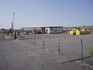
Woodside is a ghost town located on the west bank of the shallow Price River in the nearly uninhabited eastern part of Emery County, Utah, United States. Its fenced-in filling station is one of the only signs of human activity along the lonely stretch of U.S. Route 6/191 between Wellington and Green River.
Rockport is a ghost town in a narrow part of Weber Valley at the mouth of Three Mile Canyon in Summit County, Utah, United States. Located 4 miles (6.4 km) south of Wanship, it was inhabited for nearly a century before the creation of Rockport Reservoir, which covered almost the whole townsite.
Mohrland is a ghost town located in Emery County, Utah, United States. Lying in Cedar Creek Canyon near the Carbon County line, Mohrland was Emery County's largest coal mining town, with a history more typical of Carbon County's coal camps than of most Emery County communities.

Washakie is a ghost town in far northern Box Elder County, Utah, United States. Lying some 3 miles (4.8 km) southeast of Portage, it was established in 1880 by the Church of Jesus Christ of Latter-day Saints for the settlement of the Northwestern Shoshone. The Washakie Indian Farm was home to the main body of this Native American band through most of the 20th century. By the mid-1970s, Washakie's residents were gone and the property sold to a private ranching operation. Today the tribal reservation consists of a small tract containing the Washakie cemetery, and the tribe is seeking to acquire more of the surrounding land. The old LDS chapel in Washakie is now on the National Register of Historic Places.

Paria or Pahreah, is a ghost town on the Paria River in Grand Staircase–Escalante National Monument in central Kane County, Utah, United States. It was inhabited from 1870 to 1929, and later used as a filming location.

Widtsoe is a ghost town in Garfield County, Utah, United States. Located in John's Valley northeast of Bryce Canyon and along the Sevier River at the mouth of Sweetwater Creek, the town existed from about 1908 to 1936.

Giles is a ghost town located along the Fremont River in the Blue Valley of Wayne County, Utah, United States. The town was inhabited circa 1883–1919.
Hebron is a ghost town on Shoal Creek in Washington County in southwestern Utah, United States. Hebron was inhabited from 1862 until 1902, when the already-declining town was mostly destroyed by an earthquake. The present-day city of Enterprise, 6 miles (9.7 km) to the east, was settled largely by people leaving Hebron.

Duncan's Retreat is a ghost town located just off Utah State Route 9 in the eastern part of Washington County, in southwestern Utah, United States. Lying some 3 miles (4.8 km) east of Virgin and just southwest of Zion National Park, Duncan's Retreat was inhabited about 1861–1895.
McCornick is an unincorporated community and near-ghost town located in Millard County, Utah, United States. Lying in Whiskey Creek Flat 11 miles (18 km) northwest of Holden, McCornick was a failed land development project that lasted from 1919 until circa 1930. Today, McCornick is made up of a few scattered homes and farms.
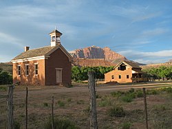
Harrisburg is a ghost town in Washington County, Utah, United States. Established as Harrisville in 1859, the town was flooded by the Virgin River in 1862, causing the residents to move farther up Quail Creek. Soon after, the town's name was changed to Harrisburg. By 1868, 200 people lived in Harrisburg; however, over the course of the next few years, floods, Native American raids, and a grasshopper plague caused people to relocate to the nearby towns of Leeds and Silver Reef. By 1895, Harrisburg was abandoned. Presently, the site of Harrisburg is occupied by a real estate project called Harrisburg Estates, but many remnants from its old days are still visible throughout town including the historic cemetery and several sandstone houses. The neighborhood now lies within the legal boundaries of Hurricane.
Adventure was an early settlement in Washington County, Utah, United States, established in 1860 by Philip Klingensmith and five other people from Iron County. They formed a small settlement as part of the cotton growing colony in the area, at a place a couple of miles up the Virgin River from Grafton. Adventure was destroyed by the Great Flood of 1862 and the settlers moved to settle on some nearby land with more space for growth and above the river floods, in what is now the center of Rockville.
Northrop, now a ghost town, was a small, early settlement in Washington County, Utah, United States, established in 1861 by Isaac Behunin. It was located at the confluence of the North Fork and East Fork of the Virgin River. It was one of the settlements formed as part of the cotton growing colony in the County.