Washington County is a county in the southwestern corner of Utah, United States. As of the 2020 United States Census, the population was 180,279, making it the fifth-most populous county in Utah. Its county seat and largest city is St. George. The county was created in 1852 and organized in 1856. It was named after the first President of the United States, George Washington. A portion of the Paiute Indian Reservation is in western Washington County. Washington County comprises the St. George, UT Metropolitan Statistical Area.

Glenwood is a town in Sevier County, Utah, United States. The population was 464 at the 2010 census.

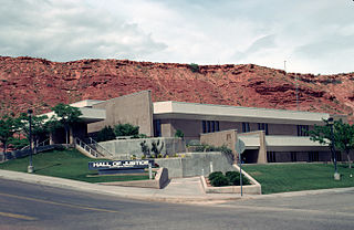
Hurricane is a city in Washington County, Utah, United States. Its population was 20,036 as of the 2020 United States Census estimates. The Hurricane valley makes up the easternmost part of the St. George Metropolitan area and is becoming a tourist gateway town to Zion National Park. Hurricane is known for its historic peach and pecan orchards, open space, green fields and small-town charm, although like much of southwestern Utah, the Hurricane valley continues to experience significant population growth.
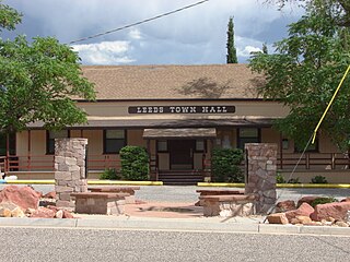
Leeds is a town in Washington County, Utah, United States. The population was 820 at the 2010 census.

Fairbank is a ghost town in Cochise County, Arizona, next to the San Pedro River. First settled in 1881, Fairbank was the closest rail stop to nearby Tombstone, which made it an important location in the development of southeastern Arizona. The town was named for Chicago investor Nathaniel Kellogg Fairbank who partially financed the railroad, and was the founder of the Grand Central Mining Company, which had an interest in the silver mines in Tombstone. Today Fairbank is located within the San Pedro Riparian National Conservation Area.

City Creek is a small but historically important mountain stream that flows from City Creek Canyon and across part of Salt Lake City, Utah, and into the Jordan River which empties into the Great Salt Lake. City Creek's head is about 8 miles (13 km) up City Creek Canyon northeast of Downtown Salt Lake City. The entire stream measures only about 14.5 miles (23 km) long. Melting snow from adjacent mountains provides most of City Creek's currents, but the stream flows year-round because of natural springs at the head of the creek.

Walhalla is a town in Victoria, Australia, founded as a gold-mining community in late 1862, and at its peak, home to around 4,000 residents. As of 2016, the town has a population of 35 permanent residents, though it has a large proportion of houses owned as holiday properties. It attracts large numbers of tourists and is a major focus of the regional tourism industry. The town's name is taken from an early gold mine in the area, named for the German hall of fame, the Walhalla temple.

Mount Carmel Junction and Mount Carmel are unincorporated communities located 12 miles (19 km) east of Zion National Park and 17 miles (27 km) north of Kanab in Kane County, Utah, United States. They lie in close proximity to the Coral Pink Sand Dunes State Park.

Mogollon, also called the Mogollon Historic District, is a former mining town located in the Mogollon Mountains in Catron County, New Mexico, United States. Located east of Glenwood and Alma, it was founded in the 1880s at the bottom of Silver Creek Canyon to support the gold and silver mines in the surrounding mountains. The "Little Fannie" mine became the most important employer for the town. During the 1890s, Mogollon had a transient population of between 3,000 and 6,000 miners. Because of its isolation, it had a reputation as one of the wildest mining towns in the West. Today Mogollon is listed as Fannie Hill Mill and Company Town Historic District on the National Register of Historic Places.

Grafton is a ghost town, just south of Zion National Park in Washington County, Utah, United States. Said to be the most photographed ghost town in the West, it has been featured as a location in several films, including 1929's In Old Arizona—the first talkie filmed outdoors—and the classic Butch Cassidy and the Sundance Kid. The nearest inhabited town is Rockville.
Rockport is a ghost town in a narrow part of Weber Valley at the mouth of Three Mile Canyon in Summit County, Utah, United States. Located 4 miles (6.4 km) south of Wanship, it was inhabited for nearly a century before the creation of Rockport Reservoir, which covered almost the whole townsite.

Paria or Pahreah, is a ghost town on the Paria River in Grand Staircase–Escalante National Monument in central Kane County, Utah, United States. It was inhabited from 1870 to 1929, and later used as a filming location.

Giles is a ghost town located along the Fremont River in the Blue Valley of Wayne County, Utah, United States. The town was inhabited circa 1883–1919.
Hebron is a ghost town on Shoal Creek in Washington County in southwestern Utah, United States. Hebron was inhabited from 1862 until 1902, when the already-declining town was mostly destroyed by an earthquake. The present-day city of Enterprise, 6 miles (9.7 km) to the east, was settled largely by people leaving Hebron.

Duncan's Retreat is a ghost town located just off Utah State Route 9 in the eastern part of Washington County, in southwestern Utah, United States. Lying some 3 miles (4.8 km) east of Virgin and just southwest of Zion National Park, Duncan's Retreat was inhabited about 1861–1895.
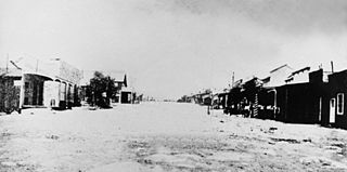
Silver Reef is a ghost town in Washington County, Utah, United States, about 15 miles (24 km) northeast of St. George and 1 mile (1.6 km) west of Leeds. Silver Reef was established after John Kemple, a prospector from Nevada, discovered a vein of silver in a sandstone formation in 1866. At first, geologists were uncertain about Kemple's find because silver is not usually found in sandstone. In 1875, two bankers from Salt Lake City sent William Barbee to the site to stake mining claims. He staked 21 claims, and an influx of miners came to work Barbee's claims and to stake their own. To accommodate the miners, Barbee established a town called Bonanza City. Property values there were high, so several miners settled on a ridge to the north of it and named their settlement Rockpile. The town was renamed Silver Reef after silver mines in nearby Pioche closed and businessmen arrived.

Quail Creek State Park is a state park of Utah, United States, featuring a 600-acre (240 ha) reservoir. The park is located within Hurricane, Utah, 9 miles (14 km) west of the city center and 1.5 miles (2.4 km) south of the historic ghost town of Harrisburg. Quail Creek State Park offers camping, boating, swimming, and fishing.
Cedar Creek is a ghost town in Box Elder County, Utah, United States. Founded in the 1860s, Cedar Creek was a farming town. Businesses included a school, an inn, and a store. The interstate highway system built through Cedar Creek and the nearby communities of Snowville and Park Valley. Cedar Creek was abandoned when weather conditions made farming difficult.
Hamblin, now a ghost town, was a Mormon pioneer town along the Mormon Road, from 1856 to 1905. It was located at an elevation of 5,832 feet in Mountain Meadow in western Washington County, Utah, United States.


