
Washington County is a county in the southwestern corner of Utah, United States. As of the 2020 United States Census, the population was 180,279, making it the fifth-most populous county in Utah. Its county seat and largest city is St. George. The county was created in 1852 and organized in 1856. It was named after the first President of the United States, George Washington. A portion of the Paiute Indian Reservation is in western Washington County. Washington County comprises the St. George, UT Metropolitan Statistical Area.
Bellevue means "beautiful view" in French.

Logan is a city in Cache County, Utah, United States. The 2020 census recorded the population was 52,778. Logan is the county seat of Cache County and the principal city of the Logan metropolitan area, which includes Cache County and Franklin County, Idaho. The Logan metropolitan area contained 147,908 people as of the 2020 census. Logan is the location of the main campus of Utah State University.

Hurricane is a city in Washington County, Utah, United States. Its population was 20,036 as of the 2020 United States Census estimates. The Hurricane valley makes up the easternmost part of the St. George metropolitan area and is near Zion National Park. Hurricane is known for its historic peach and pecan orchards, open space, and green fields.

St. George is a city in and the county seat of Washington County, Utah, United States. Located in southwestern Utah on the Arizona border, it is the principal city of the St. George Metropolitan Statistical Area (MSA). The city lies in the northeasternmost part of the Mojave Desert, immediately south of the Pine Valley Mountains, which mark the southern boundary of the Great Basin. St. George lies slightly northwest of the Colorado Plateau, which ends at the Hurricane Fault. The city is 118 miles (190 km) northeast of Las Vegas, Nevada, and 300 miles (480 km) south-southwest of Salt Lake City, Utah, on Interstate 15.

Washington is a city in south central Washington County, Utah, United States and is a part of the St. George Metropolitan Area. The area is also known as Utah's Dixie because the Mormon pioneers who settled the St. George area came to the area to raise cotton, which was milled at the cotton mill in Washington. The population was 27,993 as of 2020. Washington is a fast-growing suburb of St. George, and is the second largest city in Washington County.
Green River may refer to:

Dixie is a nickname for the populated, lower-elevation area of south-central Washington County, the southwest corner of the State of Utah. The area lies in the northeastern Mojave Desert, south of Black Ridge and west of the Hurricane Cliffs. Its winter climate is significantly more mild than the rest of Utah.

Utah Tech University (UT), formerly known as Dixie State University (DSU) and similar names, is a polytechnic 4-year public university in St. George, Utah. The university offers doctoral degrees, master's degrees, bachelor's degrees, associate degrees, and certifications. As of fall 2022, there are 12,556 students enrolled at UT.

Grafton is a ghost town, just south of Zion National Park in Washington County, Utah, United States. Said to be the most photographed ghost town in the West, it has been featured as a location in several films, including 1929's In Old Arizona—the first talkie filmed outdoors—and the classic Butch Cassidy and the Sundance Kid. The nearest inhabited town is Rockville, which now includes the Grafton ghost town inside its legal boundaries.
Gunlock is an unincorporated community in western Washington County, Utah, United States, north of Gunlock State Park.

The University of Utah Hospital is a research and teaching hospital on the campus of the University of Utah in Salt Lake City, Utah. It serves as a major regional referral center for Utah and the surrounding states of Idaho, Nevada, Wyoming, Montana and Colorado. Since 1965, it has grown to become a health care system known as University of Utah Health, which includes five hospitals and twelve community health centers. University of Utah Health is praised for the following specialties: cardiology, geriatrics, gynecology, pediatrics, rheumatology, pulmonology, neurology, oncology, orthopedics, and ophthalmology.
Archives West is an online catalog of descriptive information about the archival collections at various institutions in the western United States (Idaho, Montana, Oregon, Alaska, Utah and Washington). It was established in 2005, and is a program offering of the Orbis Cascade Alliance. From 2005 to 2015, the site was known as Northwest Digital Archives (NWDA); the name changed as part of a substantial redesign to better describe the site's content and scope.
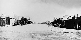
Silver Reef is a ghost town in Washington County, Utah, United States, about 15 miles (24 km) northeast of St. George and 1 mile (1.6 km) west of Leeds. Silver Reef was established after John Kemple, a prospector from Nevada, discovered a vein of silver in a sandstone formation in 1866. At first, geologists were uncertain about Kemple's find because silver is not usually found in sandstone. In 1875, two bankers from Salt Lake City sent William Barbee to the site to stake mining claims. He staked 21 claims, and an influx of miners came to work Barbee's claims and to stake their own. To accommodate the miners, Barbee established a town called Bonanza City. Property values there were high, so several miners settled on a ridge to the north of it and named their settlement Rockpile. The town was renamed Silver Reef after silver mines in nearby Pioche closed and businessmen arrived.
Pinto is an unincorporated community in Washington County, Utah, United States. It was established in 1856 by Rufus C. Allen and other leaders of the LDS Southern Indian Mission so they could move away from Fort Harmony, Utah and John D. Lee's attempts to usurp their authority.

Quail Creek State Park is a state park of Utah, United States, featuring a 600-acre (240 ha) reservoir. The park is located within Hurricane, Utah, 9 miles (14 km) west of the city center and 1.5 miles (2.4 km) south of the historic ghost town of Harrisburg. Quail Creek State Park offers camping, boating, swimming, and fishing.
Pintura or Pinturas may refer to:
The state of Utah has an increasingly diverse population, home to hundreds of thousands of Hispanic/Latino people who share ancestry from Latin American countries. It is estimated that there are roughly 383,400 residents of Hispanic/Latino descent currently living in Utah.


