
Parowan is a city in and the county seat of Iron County, Utah, United States. The population was 2,790 at the 2010 census, and in 2018 the estimated population was 3,100.

The Mountain Meadows Massacre was a series of attacks during the Utah War that resulted in the mass murder of at least 120 members of the Baker–Fancher emigrant wagon train. The massacre occurred in the southern Utah Territory at Mountain Meadows, and was perpetrated by settlers from the Church of Jesus Christ of Latter-day Saints involved with the Utah Territorial Militia who recruited and were aided by some Southern Paiute Native Americans. The wagon train, made up mostly of families from Arkansas, was bound for California, traveling on the Old Spanish Trail that passed through the Territory.
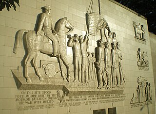
The Mormon Battalion was the only religious unit in United States military history in federal service, recruited solely from one religious body and having a religious title as the unit designation. The volunteers served from July 1846 to July 1847 during the Mexican–American War of 1846–1848. The battalion was a volunteer unit of between 534 and 559 Latter-day Saint men, led by Mormon company officers commanded by regular U.S. Army officers. During its service, the battalion made a grueling march of nearly 1,950 miles from Council Bluffs, Iowa, to San Diego, California.
George Albert Smith was an early leader in the Latter Day Saint movement. He served in the Quorum of the Twelve Apostles and as a member of the First Presidency of the Church of Jesus Christ of Latter-day Saints.
The Muddy River, formerly known as the Moapa River, is a short river located in Clark County, in southern Nevada, United States. It is in the Mojave Desert, approximately 60 miles (97 km) north of Las Vegas.

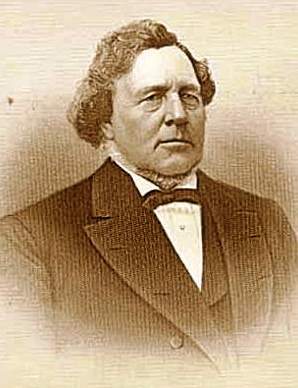
Jacob Hamblin was a Western pioneer, a missionary for the Church of Jesus Christ of Latter-day Saints, and a diplomat to various Native American tribes of the Southwest and Great Basin. He aided European-American settlement of large areas of southern Utah and northern Arizona, where he was seen as an honest broker between Latter-day Saint settlers and the Natives. He is sometimes referred to as the "Buckskin Apostle", or the "Apostle to the Lamanites". In 1958, he was inducted into the Hall of Great Westerners of the National Cowboy & Western Heritage Museum.
The Tule Desert is located in southeastern Nevada in Lincoln County, near the Utah state line. The desert lies northeast of the Mormon Mountains, south of the Clover Mountains and west of the Tule Springs Hills.

Jacob Lake is a small unincorporated community on the Kaibab Plateau in Coconino County, Arizona, United States, at the junction of U.S. Route 89A and State Route 67. Named after the Mormon explorer Jacob Hamblin, the town is known as the "Gateway to the Grand Canyon" because it is the starting point of Route 67, the only paved road leading to the North Rim of the Grand Canyon some 44 miles (71 km) to the south. The town itself consists of the Jacob Lake Inn which maintains motel rooms and cabins, a restaurant, lunch counter, gift shop, bakery, and general store; a gas station/garage; campground; and a visitors center run by the U.S. Forest Service. In the summer months, there is also a nearby center for horse rides.
The Mountain Meadows Massacre was caused in part by events relating to the Utah War, an armed confrontation in Utah Territory between the United States Army and Mormon Settlers. In the summer of 1857, however, Mormons experienced a wave of war hysteria, expecting an all-out invasion of apocalyptic significance. From July to September 1857, Mormon leaders prepared Mormons for a seven-year siege predicted by Brigham Young. Mormons were to stockpile grain, and were prevented from selling grain to emigrants for use as cattle feed. As far-off Mormon colonies retreated, Parowan and Cedar City became isolated and vulnerable outposts. Brigham Young sought to enlist the help of Indian tribes in fighting the "Americans", encouraging them to steal cattle from emigrant trains, and to join Mormons in fighting the approaching army.
The pursuit of the perpetrators of the Mountain Meadows massacre, which atrocity occurred September 11, 1857, had to await the conclusion of the American Civil War to begin in earnest.
The conspiracy and siege of the Mountain Meadows Massacre was initially planned by its Mormon perpetrators to be a short "Indian" attack, against the Baker–Fancher party. But the planned attack was repulsed and soon turned into a siege, which later culminated in the massacre of the remaining emigrants, on September 11, 1857.
The Mountain Meadows massacre was a series of attacks on the Baker–Fancher emigrant wagon train, at Mountain Meadows in southern Utah. The attacks culminated on September 11, 1857, in the mass slaughter of the emigrant party by the Iron County district of the Utah Territorial Militia and some local Indians.
The Iron Mountain District, also known as the Iron Springs District, is a large, high-grade iron deposit in southwestern Utah, near Cedar City. It is currently in care and maintenance status by CML Metals Corporation, a division of Palladon Ventures and Luxor Capital. Previous owners include Geneva Steel and U.S. Steel.
Camp Spring, is a spring, in Washington County, Utah. It lies at an elevation of 3,435 feet/1,047 meters in the reservation of the Shivwits Band of Paiutes.
Mountain Meadow or Mountain Meadows, is an area in present-day Washington County, Utah. It was a place of rest and grazing used by pack trains and drovers, on the Old Spanish Trail and later Mormons, Forty-niners, mail riders, migrants and teamsters on the Mormon Road on their way overland between Utah and California.
Holt Canyon, originally called Meadow Canyon or Meadow Valley, is a valley in Washington County, Utah. Its mouth lies at an elevation of 5,387 feet (1,642 m) where it enters the Escalante Valley. Its head lies at an elevation of 5,600 feet at 37°32′32″N113°36′46″W west of the site of the ghost town of Hamblin, Utah.
Utah Hill Summit is a summit and a gap in the Beaver Dam Mountains in Washington County, Utah. It lies at an elevation of 4,731 / 1,442 meters.
Mormon Road, also known to the 49ers as the Southern Route, of the California Trail in the Western United States, was a seasonal wagon road pioneered by a Mormon party from Salt Lake City, Utah led by Jefferson Hunt, that followed the route of Spanish explorers and the Old Spanish Trail across southwestern Utah, northwestern Arizona, southern Nevada and the Mojave Desert of California to Los Angeles in 1847. From 1855, it became a military and commercial wagon route between California and Utah, called the Los Angeles – Salt Lake Road. In later decades this route was variously called the "Old Mormon Road", the "Old Southern Road", or the "Immigrant Road" in California. In Utah, Arizona and Nevada it was known as the "California Road".
Johnson Creek, originally known as Cottonwood Creek, is a stream in iron County, Utah, United States. Its mouth is in the Cedar Valley at an elevation of 5,407 feet (1,648 m), 1.5 miles (2.4 km) south of Rush Lake, where is dissipates into the ground. Its source is a group of springs, formerly known as Elkhorn Springs, later Johnson Springs, running from north to south, at the foot of the south end of the Red Hills at 37°46′32″N113°01′31″W at an elevation of 5,500 to 5,510 feet in what is now Enoch, Utah.
Iron Springs, originally Cedar Springs, was a spring in the bed of Iron Springs Creek in what is now Iron County, Utah. The creek originally drained the western side of Cedar Valley before it was settled. Cedar Springs was located in the gap where the creek passed between the mountains of The Three Peaks and Granite Mountain. Cedar Springs was a camp for early travelers on the Mormon Road, after they had made the arduous passage from Johnson's Springs across the marshy and wooded Coal Creek. It was difficult to cross with wagons at that point in Cedar Valley. The road crossed Coal Creek midway across the valley between Johnson Springs and Cedar Springs. The travelers guide, Mormon Waybill described Cedar Spring "... wood plenty food short, Good camp". When Cedar City was established on the upper reach of Coal Creek in 1851, the road was diverted to the easy crossing there and then proceeded across the valley to Iron springs, a longer route but less arduous.


