Mormon Road

Last updated
Route of the Mormon Road 1849–1851
From the Mormon Waybill,
Distances between stops from Temple block, Salt Lake City [1] [2]
Settlements established after 1851 in italics.
LocationDistance
Willow Creek, Utah Territory
Sivogah, South Willow Creek (1849–1854)
Draperville(1854– )
20.625 mi (33.193 km)
Summit of Ridge between Utah
and Salt Lake Valleys, Utah Territory [3]
4.875 mi (7.846 km)
American Creek, Utah Territory
Lake City (1852–1860)
American Fork (1860– )
9.25 mi (14.89 km)
Provo River, Utah Territory
Fort Utah (1849–1850)
Provo City(1850– )
11.5 mi (18.5 km)
Hobble Creek, Utah Territory
Hobble Creek (1850–1853)
Springville(1853– )
7.25 mi (11.67 km)
Spanish Fork (river), Utah Territory
Spanish Fork (1851– )
6 mi (9.7 km)
Peteetneet Creek, Utah Territory
Peteetneet (1850–1853)
Payson (1853– )
5 mi (8.0 km)
Salt Creek, Utah Territory
Salt Creek (1851–1882)
Nephi (1882– )
25 mi (40 km)
Toola Creek, Utah Territory
Chicken Creek (1864–1876)
18.625 mi (29.974 km)
Sevier River Crossing, Utah Territory
Sevier River
6.25 mi (10.06 km)
Cedar Creek, Utah Territory
Cedar Springs(1855–1864)
Holden (1864– )
25.5 mi (41.0 km)
3rd Creek south of Sevier River, Utah Territory [4]
Fillmore (1851– )
10.0 mi (16.1 km) [5]
4th Creek south of Sevier River, Utah Territory [6]
Meadow Creek (1857–1864)
Meadow (1864– )
8.0 mi (12.9 km)

[7]

Willow Flats, Utah Territory
Corn Creek Indian Farm (1854–1867)
Petersburg (1859–1868)
Petersburgh (1870–1877)
Hatton (1877–1940)
3.625 mi (5.834 km) [8]
Emigrant Spring, Utah Territory [9]
Willden Fort (1860–1865)
Cove Fort (1867– )
23.0 mi (37.0 km) [10]
Sage Creek, Utah Territory [11] 22.25 mi (35.81 km)
Beaver Creek, Utah Territory
Greenville (1861– ) [12]
5.125 mi (8.248 km)
North Canyon Creek, Utah Territory [13] 27.25 mi (43.85 km)
2nd Creek, Utah Territory [14]
Paragonah (1851– )
5.375 mi (8.650 km)
3rd Creek, Utah Territory [15]
Parowan (1851– )
6.375 mi (10.260 km) [16]
Cottonwood Creek, Utah Territory [17]
Johnson Springs (1851– )
12.875 mi (20.720 km)
Cedar Springs, Utah Territory [18] 9 mi (14 km)
Pynte Creek, Utah Territory [19] 23 mi (37 km)
Road Springs, Utah Territory [20]
Meadow Canyon, Mountain Meadow
9 mi (14 km)
Santa Clara River, Utah Territory [21]
Gunlock (1857– )
16 mi (26 km)
Camp Springs, Utah Territory [22] 17.125 mi (27.560 km)
Rio Virgin, New Mexico Territory [23]
at Beaver Dam Wash
Littlefield (1865– )
22.875 mi (36.814 km)
Rio Virgin, New Mexico Territory [24]
at Virgin Hill
East end of Mormon Mesa Cutoff
39.625 mi (63.770 km)
Muddy Creek, New Mexico Territory [25]
at California Wash
West end of Mormon Mesa Cutoff, California Crossing
19.625 mi (31.583 km)
Las Vegas Wash, New Mexico Territory [26] 52.625 mi (84.692 km)
Las Vegas Springs, New Mexico Territory [27]
Fort Las Vegas (1855–1857)
Las Vegas Rancho (1865–1902)
Las Vegas (1902– )
5 mi (8.0 km)
Cottonwood Spring, New Mexico Territory [28] 17 mi (27 km)
Cottonwood Grove, New Mexico Territory [29] 29.75 mi (47.88 km)
Resting Springs, California [30] 21.75 mi (35.00 km)
Willow Spring, California [31]
on the Amargosa River
7 mi (11 km)
Salt Spring, California [32] 14.125 mi (22.732 km)
Bitter Spring, California [33] 38.75 mi (62.36 km)
Mojave River, California [34]
Fork of the Road, (junction with Mohave Trail)
Alcorn Ranch (1864–1866)
Hawley’s Station (1866–1882)
18.75 mi (30.18 km) [35]
Last Ford on the Mojave, California [36]
Lane's (1859–1865)
Oro Grande (1881– )
51.5 mi (82.9 km)
Cahoon Pass, California [37]
Coyote Canyon (1848–1850)
Hogback Cutoff (1851–1855)
Sanford Cutoff (1855–1861)
Cajon Pass Toll Road (1861– )
17 mi (27 km)
? Camp, California [38] 10 mi (16 km)
Coco Mongo Ranch, California11.5 mi (18.5 km)
Del Chino Ranch, California [39] 10 mi (16 km)
San Gabriel River, California19.375 mi (31.181 km)
San Gabriel Mission, California
San Gabriel (1852– )
6 mi (9.7 km)
Pueblo de Los Ángeles, California
Los Angeles (1850– )
6 mi (9.7 km)
San Pedro, California [40] 23.00 mi (37.01 km)

Mormon Road, also known to the 49ers as the Southern Route, of the California Trail in the Western United States, was a seasonal wagon road pioneered by a Mormon party from Salt Lake City, Utah led by Jefferson Hunt, that followed the route of Spanish explorers and the Old Spanish Trail across southwestern Utah, northwestern Arizona, southern Nevada and the Mojave Desert of California to Los Angeles in 1847. From 1855, it became a military and commercial wagon route between California and Utah, called the Los Angeles – Salt Lake Road. In later decades this route was variously called the "Old Mormon Road", the "Old Southern Road", or the "Immigrant Road" in California. In Utah, Arizona and Nevada it was known as the "California Road".

Contents

Mormon Road 1847–1855

Jefferson Hunt and Mormon Veterans Expeditions 1847–1848

Jefferson Hunt JeffersonHunt.jpg
Jefferson Hunt

The wagon road later called the "Mormon Road" was pioneered by a Mormon party with pack horses, led by Jefferson Hunt, intent on obtaining supplies for the struggling, newly founded Salt Lake City, traveling to and from Southern California in the fall and winter of 1847–1848. Following Hunt's route back to Utah in 1848 were discharged veterans of the Mormon Battalion, taking the first wagons over the old pack trail. This route created by the returning veterans confirmed that a wagon route could be made from Salt Lake City southwest through southwestern Utah to link to the Old Spanish Trail at Parowan, that then followed the old pack trail, southwest to the Virgin River. Then using John Fremont's cutoff from the Virgin River at Halfway Wash, crossed southern Nevada, passing over the arid country between the Muddy River and Las Vegas Springs, then over the Spring Mountains at Mountain Springs and Nopah Range beyond through Emigrant Pass to Resting Springs in Southern California. Then, again following the Old Spanish Trail, southwest along the Amargosa River to Salt Spring then a long dry haul across the Mojave Desert to Bitter Spring and on to the Mojave River at Fork of the Road with the Mohave Trail. From there the route followed the river upstream to the crossing at its lower narrows. There they left the river, crossing the remaining desert to Cajon Summit on Baldy Mesa, then descended past Cajon Pass, through Crowder Canyon and the lower Cajon Canyon to the San Bernardino Valley. The road crossed the valley to the Rancho Santa Ana del Chino and then followed the Sonora Road from there west to the pueblo of Los Angeles. [41] :1–17

Southern Route of the California Trail

Route of the Old Spanish Trail from Santa Fe to Los Angeles. OldSpanishTrail.png
Route of the Old Spanish Trail from Santa Fe to Los Angeles.

The first large use of the route pioneered by Hunt and the Veterans were hundreds of late arriving Forty-niners, and some parties of Mormons, both packers and teamsters, looking to avoid the fate of the Donner Party, by using this snow free route into California in the fall and winter of 1849–1850. From Parowan onward to the southwest, the original route closely followed the route of the Old Spanish Trail diverting from that route between the Virgin River at Halfway Wash to Resting Springs, following the cutoff discovered by John Frémont on his return from California in 1844. This road only diverted to find places that could be traversed by the wagons of Mormon and Forty-niner parties that pioneered it. The principal change was the shortcut from the Virgin River where the road ascended to Mormon Mesa at Virgin Hill, crossed the mesa to the Muddy River and its crossing at California Wash. This saved the longer route to Halfway Wash through the quicksands along the Virgin River. The later immigrants and the Mormon colonists of San Bernardino, in the early 1850s found a better route through Cajon Pass along a hogback in the western side of the Upper Cajon Pass overlooked by Baldy Mesa. At the same time along the Mormon Road were being seeded many of the Mormon settlements that developed into towns and cities of modern Utah, Arizona, Nevada and Southern California. [41] :44–70 [42]

Los Angeles – Salt Lake Road 1855–1905

By mid-1855 the Mormon Road had been improved and rerouted, to make it a military and commercial wagon road that ran between Salt Lake City, Utah and Los Angeles, California. In Cajon Pass the State of California paid to reroute the road from Coyote Canyon route to the Sanford Cutoff and made improvements to the route as far as the California border. In Utah Territory, the Federal government sent an engineer that built Leach's Cutoff between Cedar City and Mountain Meadow that shortened the route between Johnson Springs (now known as Enoch) and the meadow by 15 miles (24 km), avoiding the longer route via Cedar Spring, Antelope Spring, Pyute Creek to Road Springs at the lower end of Mountain Meadow. The road was also rerouted between Cove Creek to the crossing of Beaver River at modern Beaver, 3 miles (4.8 km) upriver from the old one at what in 1861 became the site of Greenville. This change was made with the major alteration from the new Beaver River crossing to Muley Point to shorten the route and avoid a difficult section of 6 miles (9.7 km) up California Hollow and over a steep mountain ridge in the Black Mountains, better suited to the Old Spanish Trail mule trains than wagons. The terrain feature called Doubleup Hollow at the point that steep ascent began is indicative of the technique of doubling up the wagon teams that was required to get wagons over the worst part of the climb. The new route passed through more wagon-friendly terrain in Nevershine Hollow and over Beaver Ridge into the canyon of Fremont Wash where it rejoined the original road. This route is the one Interstate 15 runs along today. [41] :155–57

The road then soon became a winter seasonal route for trains of wagons carrying goods shipped by sea from San Francisco to San Pedro and then to Los Angeles. The trains left Los Angeles, (and later San Bernardino), for Salt Lake City during the late fall and returned by the end of the spring season, ending the isolation of Utah when the passes of the Sierra Nevada Mountains and Rocky Mountains were closed by snow. In California, the road became known as the Los Angeles – Salt Lake Road or Salt Lake Road, and in Utah and Nevada, the California Road. [41] :153–78

In 1858, following the Mountain Meadows Massacre, the Dukes-Turner wagon company pioneered an alternate wagon route to avoid Leach's Cutoff and Mountain Meadow. It ran from Cedar City southward via the Black Ridge grade to the Virgin River, then up the Santa Clara River to link up with the old route of the Mormon Road at Camp Spring. As the Mormons began to settle the area from 1858, they opened stations at Washington and Fort Harmony to provide for feed and provisions to passing freighters for trade goods or cash. [41] :140–41,207

In the 1860s the wagon road was a route of trade and migration from California to the gold rush country in Idaho and Montana. It was also the route of continued Mormon colonization of Washington County in Utah Territory and the lower reach of the Virgin River, in northern Arizona Territory, that part that later became Clark County, Nevada. [41] :171,207–10

In 1865, the Miller Cutoff was constructed as a freight wagon road, to the north of the Virgin River to bypass the many crossings of that river, its quicksands, its sandy roads and the steep road into and out of the river valley at Virgin Hill. It ran between the old road at Castle Cliff, west to Mormon Well 12 miles (19 km) up Beaver Dam Creek from the Virgin River, then westward south of the mountains, to rejoin the old road on Mormon Mesa, south of Mormon Mountain. [41] :6,210–11

With the advent of the transcontinental railroad in Utah in 1869, the wagon road was used decreasingly when long-haul wagons were replaced by wagons from the rail-heads as the rails advanced southwestward in Utah between the 1870s and 1890s. However, as a long-haul road it remained in use in Southern California until the Santa Fe Railroad came to Southern California in 1883. The northern Mojave Desert region of California, southern Nevada, and northwestern Arizona still used the road until the Salt Lake Route was built through them in 1903–1905. [41] :174–78,217

Legacy

In the early 20th Century, much of the old road became the Arrowhead Trail (auto trail) one of the first automobile highways in and between Utah, Southern Nevada and Southern California. I-15 follows or closely parallels its route for much of its length from Devore, California to Victorville, California, from Barstow, to Yermo, California, from Las Vegas, Nevada to Littlefield, Arizona and from St. George, Utah to Salt Lake City.

See also

Related Research Articles

<span class="mw-page-title-main">Oregon Trail</span> Historic route connecting the Missouri River to valleys in Oregon

The Oregon Trail was a 2,170-mile (3,490 km) east–west, large-wheeled wagon route and emigrant trail in the United States that connected the Missouri River to valleys in Oregon Territory. The eastern part of the Oregon Trail spanned part of what is now the state of Kansas and nearly all of what are now the states of Nebraska and Wyoming. The western half of the trail spanned most of the current states of Idaho and Oregon.

<span class="mw-page-title-main">Mojave River</span> River in California, United States

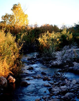
The Mojave River is an intermittent river in the eastern San Bernardino Mountains and the Mojave Desert in San Bernardino County, California, United States. Most of its flow is underground, while its surface channels remain dry most of the time, except for the headwaters and several bedrock gorges in the lower reaches.

<span class="mw-page-title-main">Mormon Trail</span> Migrant route from Illinois to Salt Lake City, Utah

The Mormon Trail is the 1,300-mile (2,100 km) long route from Illinois to Utah on which Mormon pioneers traveled from 1846–47. Today, the Mormon Trail is a part of the United States National Trails System, known as the Mormon Pioneer National Historic Trail.

<span class="mw-page-title-main">California Trail</span> Historic migration route in the western United States

The California Trail was an emigrant trail of about 1,600 mi (2,600 km) across the western half of the North American continent from Missouri River towns to what is now the state of California. After it was established, the first half of the California Trail followed the same corridor of networked river valley trails as the Oregon Trail and the Mormon Trail, namely the valleys of the Platte, North Platte, and Sweetwater rivers to Wyoming. The trail has several splits and cutoffs for alternative routes around major landforms and to different destinations, with a combined length of over 5,000 mi (8,000 km).

<span class="mw-page-title-main">Muddy River (Nevada)</span> River in Nevada, United States

The Muddy River, formerly known as the Moapa River, is a short river located in Clark County, in southern Nevada, United States. It is in the Mojave Desert, approximately 60 miles (97 km) north of Las Vegas.

<span class="mw-page-title-main">Old Spanish Trail (trade route)</span> United States historic place

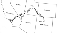
The Old Spanish Trail is a historical trade route that connected the northern New Mexico settlements of Santa Fe, New Mexico with those of Los Angeles, California and southern California. Approximately 700 mi (1,100 km) long, the trail ran through areas of high mountains, arid deserts, and deep canyons. It is considered one of the most arduous of all trade routes ever established in the United States. Explored, in part, by Spanish explorers as early as the late 16th century, the trail was extensively used by traders with pack trains from about 1830 until the mid-1850s. The area was part of Mexico from Mexican independence in 1821 to the Mexican Cession to the United States in 1848.

<span class="mw-page-title-main">Mojave Road</span> Historical trails and roads

The Mojave Road, also known as Old Government Road, is a historic route and present day dirt road across what is now the Mojave National Preserve in the Mojave Desert in the United States. This rough road stretched 147 miles (237 km) from Beale's Crossing, to Fork of the Road location along the north bank of the Mojave River where the old Mojave Road split off from the route of the Old Spanish Trail/Mormon Road.

<span class="mw-page-title-main">Emigrant Trail in Wyoming</span> 19th century pioneer route in western United States

The Emigrant Trail in Wyoming, which is the path followed by Western pioneers using the Oregon, California, and Mormon Trails, spans 400 miles (640 km) through the U.S. state of Wyoming. The trail entered from Nebraska on the eastern border of the state near the present day town of Torrington and exited on the western border near the towns of Cokeville and Afton. An estimated 350,000 to 400,000 settlers traveled on the trail through Wyoming between 1841 and 1868. All three trails follow the same path through most of the state. The Mormon Trail splits at Fort Bridger and enters Utah, while the Oregon and California Trails continue to Idaho.

The Salt Lake Cutoff is one of the many shortcuts that branched from the California, Mormon and Oregon Trails in the United States. It led northwest out of Salt Lake City, Utah and north of the Great Salt Lake for about 180 miles (290 km) before rejoining the California trail near the City of Rocks, Idaho. From there Oregon Trail travelers could easily travel down the Raft River valley portion of the California Trail to return to the Oregon Trail. It provided a way to stop in Salt Lake City for repairs, fresh supplies, fresh livestock, etc. In later years it was used by tens of thousands of pioneers and miners going east and west on their way to or from the future states of California, Oregon, Utah, Idaho, Montana, Nevada or Washington.

In the history of the American frontier, pioneers built overland trails throughout the 19th century, especially between 1829 and 1870, as an alternative to sea and railroad transport. These immigrants began to settle much of North America west of the Great Plains as part of the mass overland migrations of the mid-19th century. Settlers emigrating from the eastern United States did so with various motives, among them religious persecution and economic incentives, to move from their homes to destinations further west via routes such as the Oregon, California, and Mormon Trails. After the end of the Mexican–American War in 1849, vast new American conquests again encouraged mass immigration. Legislation like the Donation Land Claim Act and significant events like the California Gold Rush further encouraged settlers to travel overland to the west.

<span class="mw-page-title-main">Route of the Oregon Trail</span>

The historic 2,170-mile (3,490 km) Oregon Trail connected various towns along the Missouri River to Oregon's Willamette Valley. It was used during the 19th century by Great Plains pioneers who were seeking fertile land in the West and North.

Bitter Spring is a spring within the Fort Irwin National Training Center in San Bernardino County, California. It lies at an elevation of 1355 feet and is located in a valley between the Soda Mountains to the east, the Tiefort Mountains to the northwest, Alvord Mountain to the southwest and Cronese Mountains to the south and southeast.

Camp Spring, is a spring, in Washington County, Utah. It lies at an elevation of 3,435 feet/1,047 meters in the reservation of the Shivwits Band of Paiutes.

Crowder Canyon, originally Coyote Canyon, is a valley in San Bernardino County, California. Its mouth was at an elevation of 2,999 feet / 914 meters at its confluence with Cajon Canyon. Its source was at an elevation of 4200 feet at 34°21′02″N117°26′04″W near Cajon Summit. The canyon runs southward just west of the top of Cajon Pass then turns southwestward to meet Cajon Canyon.

Sevier River Crossing of the Mormon Road was located above the confluence of the Sevier River with Chicken Creek, in Mills Valley, Juab County, Utah. The Crossing was located 120 miles from Salt Lake City, 24.875 miles south of Nephi and 25.5 miles north of Holden, on the Mormon wagon road to Los Angeles.

Fremont Wash sometimes called Fremont Canyon in its upper reach, is a stream and a valley in the north end of Parowan Valley, in Iron County, Utah. Its mouth lies at its confluence with Little Salt Lake at an elevation of 5,686 feet. Its head is found at 38°07′46″N112°34′36″W, the mouth of Fremont Canyon, an elevation of 6,476 feet.

Red Creek is a stream in Iron County, Utah. Its mouth lies at an elevation of 5,925 feet near Paragonah, Utah. Its source is located at an elevation of 9,560 feet at 37°48′55″N112°40′32″W near Willow Spring in the Markagunt Plateau.

Utah Hill Summit is a summit and a gap in the Beaver Dam Mountains in Washington County, Utah. It lies at an elevation of 4,731 / 1,442 meters.

Indian Creek originally known as Sage Creek, is a tributary stream of the Beaver River in Beaver County, Utah. Its mouth is at its confluence with the Beaver River at an elevation of 5,499 feet above the Minersville Reservoir, 0.4 miles south of Adamsville. Its source is at 38°24′31″N112°26′55″W, on the northwest slope of Mount Baldy at an elevation of 10,600 feet in the Tushar Mountains.

Iron Springs, originally Cedar Springs, was a spring in the bed of Iron Springs Creek in what is now Iron County, Utah. The creek originally drained the western side of Cedar Valley before it was settled. Cedar Springs was located in the gap where the creek passed between the mountains of The Three Peaks and Granite Mountain. Cedar Springs was a camp for early travelers on the Mormon Road, after they had made the arduous passage from Johnson's Springs across the marshy and wooded Coal Creek. It was difficult to cross with wagons at that point in Cedar Valley. The road crossed Coal Creek midway across the valley between Johnson Springs and Cedar Springs. The travelers guide, Mormon Waybill described Cedar Spring "... wood plenty food short, Good camp". When Cedar City was established on the upper reach of Coal Creek in 1851, the road was diverted to the easy crossing there and then proceeded across the valley to Iron springs, a longer route but less arduous.

References

  1. LeRoy Reuben Hafen, Ann Woodbury Hafen, Journals of Forty-niners: Salt Lake to Los Angeles: with Diaries and Contemporary Records of Sheldon Young, James S. Brown, Jacob Y. Stover, Charles C. Rich, Addison Pratt, Howard Egan, Henry W. Bigler, and Others, U of Nebraska Press, 1954, pp. 321–24 Mormon Waybill, Joseph Cain and A. C. Brower, Salt Lake City, 1851. Road distances from readings of roadometer attached to the wagon of Addison Pratt of the 1849 Jefferson Hunt Wagon Train.
  2. Randolph Barnes Marcy, The Prairie Traveler. A Hand-Book for Overland Expeditions. With Maps, Illustrations, and Itineraries of the Principal Routes Between the Mississippi and the Pacific. Published by Authority of the ard Department, 1859; Itinerary VI. From Great Salt Lake City to Los Angeles and San Francisco, California. from the Kansas Collection website accessed 05/22/2015
  3. U.S. Geological Survey Geographic Names Information System: Point of the Mountain, at an elevation of 5,079 feet / 1,548 meters, location: 40°27′13″N111°54′38″W / 40.45361°N 111.91056°W
  4. The third stream crossed south of the Sevier River, is now called Chalk Creek.
  5. Leroy R. Hafen and Ann W. Hafen, eds., Journals of Forty-Niners: Salt Lake to Los Angeles (Glendale, CA: Arthur H. Clark Co., 1954), p. 64, note 25
  6. This is the fourth stream south of the Sevier River. Road crosses two streams. Prairie Traveler
  7. 18.0 miles from Cedar Creek, 8 miles from Chalk Creek. Hafen, Journals of Forty-Niners, p. 64 note 27
  8. 4 miles from Meadow Creek. Hafen, Journals of Forty-Niners, p. 64 note 27
  9. Mormon Waybill – Spring – Good grass and water.
  10. Hafen, Journals of Forty-niners: Salt Lake to Los Angeles. Distances quoted for October 16th by several members of the 1849 Hunt Wagon Train, between Willow Flat and Emigrant Spring, (later site of Cove Fort) in Cove Creek Valley: given by Sheldon Young Journal, October 16th, p. 65, 21 miles. Distance given by Addison Pratt Diary, October 16th, p. 73, 23 miles. Distance given by Charles Rich Journal, October 16th, p. 182, 22 miles. 1851 Mormon Waybill, 25 miles. However Pratt towed the roadometer and recorded all measurements, so presumably the Waybill figure based on Pratt's measurements, is a typographical error by the printer.
  11. Mormon Waybill – Wood, food poor. Later renamed Indian Creek, from the original Sage Creek. U.S. Geological Survey Geographic Names Information System: Indian Creek
  12. Greenville was built on the site of the original crossing of the road before 1855 when the road was realigned to cross upriver at the location of modern Beaver, Utah.
  13. Marcy, Prairie Traveler, 1859. "In Little Salt Lake Valley. Good grass; no wood. The road is rough and steep for six miles. Camp located near Wheatgrass, Utah.
  14. Mormon Waybill – Good wood, water, and grass.
  15. Mormon Waybill – "Good wood, water, and grass."
  16. 6.75 miles Hafen, Journals, p. 322
  17. Mormon Waybill – "... good feed and water."
  18. Mormon Waybill – "Coal Creek, bad to cross, wood plenty food short, Good camp". The road crossed Coal Creek midway across the valley between Johnson Springs and Cedar Springs. Marshy and wooded it was difficult to cross with wagons at that point. When Cedar City was established on the upper reach of Coal Creek in 1851, the road was diverted to the easy crossing there and then proceeded across the valley to Iron springs, a longer route but less arduous.
  19. Mormon Waybill – "Good grass one mile up the canyon." Pynte Creek, now Pinto Creek, was originally called Pyute Creek for the natives that lived along it. The name changed in the Mormon Waybill, and may be the result of a dyslexic typesetter turning the "u" upside down. Subsequently the name was copied and popularized by Marcy's Prairie Traveler.
  20. Mormon Waybill – "Road is rough; good camp."
  21. Mormon Waybill – "Road descending and rough; poor grass."
  22. Mormon Waybill – "Two miles before reaching the springs the road leaves the Santa Clara. Good grass."
  23. Mormon Waybill – "Road crosses over the summit of a mountain. Good road; grass poor." This section of the road reached the Virgin River at Beaver Dam Wash, just where Littlefield, Arizona is today.
  24. Mormon Waybill – "Road runs down the Rio Virgin, crossing it ten times. Grass good down the river." Camp at the river crossing just below Virgin Hill, where the trail up to the top of Mormon Mesa begins.
  25. Mormon Waybill – "Road for half a mile is very steep and sandy. Good camp."
  26. Mormon Waybill – "Good camp – Water is sometimes found 2 1/2 miles west of the road in holes 23 miles from the Muddy, and some grass about a mile from the road."
  27. Mormon Waybill – On Vagas Wash – "Road runs up the river. Good grass."
  28. Mormon Waybill – "Poor grass."
  29. Mormon Waybill – "No grass. Water and grass can be found four miles west by following the old Spanish trail to a ravine, and thence to the left in the ravine one mile."
  30. Mormon Waybill – "Good grass and water. Animals should be rested here before entering the desert."
  31. Mormon Waybill – "The spring is on the left of the road, and flows into Saleratus Creek. Animals must not be allowed to drink the Saleratus water."
  32. Mormon Waybill – "Poor grass and no fresh water."
  33. Mormon Waybill – "Good road; poor grass."
  34. Mormon Waybill – "Good road and good grass."
  35. This measurement was wrong, it is about 12 miles to Impassable Pass from Bitter Spring, and 18 miles from the pass to Fork of the Road.
  36. Mormon Waybill – "Last ford. Good grass all the way up the Mojave."
  37. Mormon Waybill – "At the summit."
  38. Mormon Waybill – "Road bad down the canon." The bad road was down Crowder Canyon. Once only the route of pack horse trains in single file, the first wagons had difficulty passing down the old horse trail, rocks had to be moved, trail widened or the wagons taken apart and carried over intractable obstructions. Soon an alternate and marginally less difficult route was found on a steep hogback to the west and a passable road built nearby to the west of the hogback in 1855 called the Sanford Cutoff between Baldy Mesa and upper Cajon Canyon. Later, in 1861, as a result of the Holcomb Valley gold rush, the difficult but shorter, Crowder Canyon route was made into a good road and a toll charged.
  39. Mormon Waybill – "Williams".
  40. Distance between Los Angeles and the anchorage at San Pedro is from Itinerary XX. Captain Whipple's Route from Albuquerque, New Mexico, to San Pedro, California, in Marcy, Randolph Barnes, The Prairie Traveler. A hand-book for overland expedition, Harper & Brothers, New York, 1861. p. 331 from archive.org accessed October 31, 2015
  41. 1 2 3 4 5 6 7 8 Edward Leo Lyman, Overland Journey from Utah to California: Wagon Travel from the City of Saints to the City of Angels, University of Nevada Press, 2008.
  42. LeRoy Reuben Hafen, Ann Woodbury Hafen, Journals of Forty-niners: Salt Lake to Los Angeles: with Diaries and Contemporary Records of Sheldon Young, James S. Brown, Jacob Y. Stover, Charles C. Rich, Addison Pratt, Howard Egan, Henry W. Bigler, and Others, U of Nebraska Press, 1954