Related Research Articles

The Mormon Trail is the 1,300-mile (2,100 km) long route from Illinois to Utah on which Mormon pioneers traveled from 1846–47. Today, the Mormon Trail is a part of the United States National Trails System, known as the Mormon Pioneer National Historic Trail.
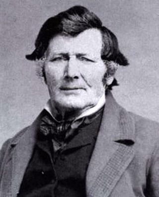
Addison Pratt was an early Latter-day Saint convert and missionary. Pratt preached in French Polynesia from 1844 to 1848 and from 1850 to 1852, and is recognized by the Church of Jesus Christ of Latter-day Saints as the first Latter-day Saint missionary to preach in a language other than English.
In the history of the American frontier, pioneers built overland trails throughout the 19th century, especially between 1840 and 1847 as an alternative to sea and railroad transport. These immigrants began to settle much of North America west of the Great Plains as part of the mass overland migrations of the mid-19th century. Settlers emigrating from the eastern United States did so with various motives, among them religious persecution and economic incentives, to move from their homes to destinations further west via routes such as the Oregon, California, and Mormon Trails. After the end of the Mexican–American War in 1849, vast new American conquests again encouraged mass immigration. Legislation like the Donation Land Claim Act and significant events like the California Gold Rush further encouraged settlers to travel overland to the west.

Peteetneet Creek is a stream in Payson Canyon, south of Payson, Utah, United States.
Bitter Spring is a spring within the Fort Irwin National Training Center in San Bernardino County, California. It lies at an elevation of 1355 feet and is located in a valley between the Soda Mountains to the east, the Tiefort Mountains to the northwest, Alvord Mountain to the southwest and Cronese Mountains to the south and southeast.
Camp Spring, is a spring, in Washington County, Utah. It lies at an elevation of 3,435 feet/1,047 meters in the reservation of the Shivwits Band of Paiutes.
Crowder Canyon, originally Coyote Canyon, is a valley in San Bernardino County, California. Its mouth was at an elevation of 2,999 feet / 914 meters at its confluence with Cajon Canyon. Its source was at an elevation of 4200 feet at 34°21′02″N117°26′04″W near Cajon Summit. The canyon runs southward just west of the top of Cajon Pass then turns southwestward to meet Cajon Canyon.
Sevier River Crossing of the Mormon Road was located above the confluence of the Sevier River with Chicken Creek, in Mills Valley, Juab County, Utah. The Crossing was located 120 miles from Salt Lake City, 24.875 miles south of Nephi and 25.5 miles north of Holden, on the Mormon wagon road to Los Angeles.
Chalk Creek is a stream in Millard County, Utah, United States.
Meadow Creek is a stream in Millard County, Utah. It was originally known as 4th Creek south of Sevier River to the early travelers on the Mormon Road. Its mouth is located at an elevation of 4,842 feet or 1,476 meters. Its source is located an elevation of 9,760 feet, at 38°51′50″N112°14′16″W near the summit of White Pine Peak in the Pahvant Range. Meadow is located north of the mouth of the stream.
Corn Creek, also called Kanosh Creek, is a stream in Millard County, Utah. Its mouth is located in the Pahvant Valley. Its source is at the confluence of East Fork Corn Creek and West Fork Corn Creek in the Pahvant Range.
Cove Creek is a stream in Beaver County and Millard County, Utah. It originates at the head of its canyon southeast of Cove Fort at 38°38′09″N112°29′34″W in Beaver County. It drains north down through the Tushar Mountains then turns west at the foot of Sulphur Peak running between the south end of the Pavant Range and the Tushar Mountains, past Cove Fort, from which it received its name. It then runs west past the north end of the Mineral Mountains to disappear into the sands of the desert at Beaver Bottoms.
Fremont Wash sometimes called Fremont Canyon in its upper reach, is a stream and a valley in the north end of Parowan Valley, in Iron County, Utah. Its mouth lies at its confluence with Little Salt Lake at an elevation of 5,686 feet. Its head is found at 38°07′46″N112°34′36″W, the mouth of Fremont Canyon, an elevation of 6,476 feet.
Red Creek is a stream in Iron County, Utah. Its mouth lies at an elevation of 5,925 feet near Paragonah, Utah. Its source is located at an elevation of 9,560 feet at 37°48′55″N112°40′32″W near Willow Spring in the Markagunt Plateau.
Parowan Creek, is a stream in the Parowan Valley of Iron County, Utah. It flows north through Parowan, Utah to its mouth at an elevation of 5,686 feet at the Little Salt Lake in Parowan Valley. Its source is located at an elevation of 9,980 feet at 37°40′57″N112°51′16″W in Brian Head, Utah in the Markagunt Plateau.
Utah Hill Summit is a summit and a gap in the Beaver Dam Mountains in Washington County, Utah. It lies at an elevation of 4,731 / 1,442 meters.
Mormon Road, also known to the 49ers as the Southern Route, of the California Trail in the Western United States, was a seasonal wagon road pioneered by a Mormon party from Salt Lake City, Utah led by Jefferson Hunt, that followed the route of Spanish explorers and the Old Spanish Trail across southwestern Utah, northwestern Arizona, southern Nevada and the Mojave Desert of California to Los Angeles in 1847. From 1855, it became a military and commercial wagon route between California and Utah, called the Los Angeles – Salt Lake Road. In later decades this route was variously called the "Old Mormon Road", the "Old Southern Road", or the "Immigrant Road" in California. In Utah, Arizona and Nevada it was known as the "California Road".
Indian Creek, originally known as Sage Creek, is a tributary stream of the Beaver River in Beaver County, Utah. Its mouth is at its confluence with the Beaver River at an elevation of 5,499 feet above the Minersville Reservoir, 0.4 miles south of Adamsville. Its source is at 38°24′31″N112°26′55″W, on the northwest slope of Mount Baldy at an elevation of 10,600 feet in the Tushar Mountains.
Johnson Creek, originally known as Cottonwood Creek, is a stream in iron County, Utah, United States. Its mouth is in the Cedar Valley at an elevation of 5,407 feet (1,648 m), 1.5 miles (2.4 km) south of Rush Lake, where is dissipates into the ground. Its source is a group of springs, formerly known as Elkhorn Springs, later Johnson Springs, running from north to south, at the foot of the south end of the Red Hills at 37°46′32″N113°01′31″W at an elevation of 5,500 to 5,510 feet in what is now Enoch, Utah.
Iron Springs, originally Cedar Springs, was a spring in the bed of Iron Springs Creek in what is now Iron County, Utah. The creek originally drained the western side of Cedar Valley before it was settled. Cedar Springs was located in the gap where the creek passed between the mountains of The Three Peaks and Granite Mountain. Cedar Springs was a camp for early travelers on the Mormon Road, after they had made the arduous passage from Johnson's Springs across the marshy and wooded Coal Creek. It was difficult to cross with wagons at that point in Cedar Valley. The road crossed Coal Creek midway across the valley between Johnson Springs and Cedar Springs. The travelers guide, Mormon Waybill described Cedar Spring "... wood plenty food short, Good camp". When Cedar City was established on the upper reach of Coal Creek in 1851, the road was diverted to the easy crossing there and then proceeded across the valley to Iron springs, a longer route but less arduous.
References
- ↑ LeRoy Reuben Hafen, Ann Woodbury Hafen, Journals of Forty-niners: Salt Lake to Los Angeles: with Diaries and Contemporary Records of Sheldon Young, James S. Brown, Jacob Y. Stover, Charles C. Rich, Addison Pratt, Howard Egan, Henry W. Bigler, and Others, U of Nebraska Press, 1954, pp.321-324, Mormon Waybill, Joseph Cain and A. C. Brower, Salt Lake City, 1851. Road distances from readings of roadometer attached to the wagon of Addison Pratt of the 1849 Jefferson Hunt Wagon Train.
- ↑ Randolph Barnes Marcy, THE PRAIRIE TRAVELER. A HAND-BOOK FOR OVERLAND EXPEDITIONS. WITH MAPS, ILLUSTRATIONS, AND ITINERARIES OF THE PRINCIPAL ROUTES BETWEEN THE MISSISSIPPI AND THE PACIFIC., PUBLISHED BY AUTHORITY OF THE WAR DEPARTMENT, 1859; ITINERARY VI. From Great Salt Lake City to Los Angeles and San Francisco, California. from the Kansas Collection website accessed 05/22/2015
- ↑ U.S. Geological Survey Geographic Names Information System: Wild Goose Creek
39°06′11″N112°16′11″W / 39.10306°N 112.26972°W
| | This article related to a river in Utah is a stub. You can help Wikipedia by expanding it. |