Fort Utah

Last updated
Fort Utah on the Timpanogas (Provo River) River, 1850 Fort Utah c1850.jpg
Fort Utah on the Timpanogas (Provo River) River, 1850

Fort Utah (also known as Fort Provo [1] ) was the original European American settlement at modern-day Provo, Utah, United States. The settlement was established March 12, 1849 by President John S. Higbee with approximately 150 persons sent from Salt Lake City to Provo by President Brigham Young. [2]

Contents

Located west of present-day downtown Provo, the fort consisted of several log dwellings, surrounded by a 14-foot (4.3 m) palisade 20 by 40 rods in size (330 by 660 feet [100 by 200 m]), with gates in the east and west ends, and a middle deck, for a cannon. Following flooding, the settlement was moved to the current location of Provo's North Park in 1850. [3] [2]

Battle at Fort Utah

Fort Utah in 1849 Fort Utah.png
Fort Utah in 1849

In late 1849, tensions between the Ute people and members of the Church of Jesus Christ of Latter-day Saints in Utah Valley escalated after a Church member killed a Ute known as Old Bishop, whom he accused of stealing his shirt. [4] The Mormon and two associates then hid the victim's body in the Provo River. Details of the murder were likely withheld, at least initially, from Brigham Young and other Church leaders. Settlers at Fort Utah did, however, report other difficulties with the Indians, including the firing of weapons at settlers and the theft of livestock and crops. Brigham Young counseled patience, telling them to "stockade your fort, to attend to your own affairs and let the Indians take care of theirs." [5] Tensions mounted at Fort Utah after the Utes demanded that the settlers turn over the murderers [6] because the settlers refused to turn over those involved in the murder of Old Bishop to the Utes or to pay reparations for his death. In the winter of 1849–1850, a measles epidemic spread from the Mormon settlers to the Ute camps, killing many Indians and heightening tensions. At a council of ecclesiastical leaders in Salt Lake City on January 31, 1850, the leader of Fort Utah reported that the Utes' actions and intentions were growing increasingly aggressive: "they say they mean to hunt our Cattle. & go & get the other Indians to kill us." [7] In response, Brigham Young authorized a campaign against the Utes [8] telling them to kill all the men and take the women and children captive. On February 8, 1850, a militia from Salt Lake surrounded a group of around seventy people at Big Elk. After two days of fighting, the Utes surrendered. The army killed the men and sent the women and children up to Salt Lake as prisoners. A series of battles in February 1850 resulted in the deaths of dozens of Utes and one Mormon. [9] These events contributed to the Walker War. [10]

Monuments and replica

1937 Monument built by the Daughters of Utah Pioneers Fort Utah Monument, Oct 16.jpg
1937 Monument built by the Daughters of Utah Pioneers

On August 30, 1937, a monument to commemorate the fort was dedicated at what was believed to be the original site of the 1849 structure. [11] The monument was erected by the Daughters of Utah Pioneers with assistance from the Sons of Utah Pioneers. Constructed with a concrete base and a center section of native stone, the monument was topped with cement molded into a fluted shape meant to reflect the fort's architecture. Also included in the monument's construction was a metal plaque with a history of the fort. [12]

Decades later, Provo City purchased the property surrounding the monument and with the help of the Utah Lake Lions Club began to develop a public park on the land, known as "Fort Utah Park." [13] [14] A miniature replica of the 1849 fort was included as part of the park's initial construction. The replica included log construction, embrasures, a cannon situated on a raised center platform, and two block houses in opposite corners of the structure. [15] The replica was completed in August 1972, in time to host that year's annual encampment of the Sons of Utah Pioneers. Citing safety issues and lack of historical accuracy in the replica, the structure was demolished by Provo City in early 2017. [16]

In the late 1990s, a committee tasked with researching the original 1849 structure in preparation for Provo's sesquicentennial celebration determined that the location of the 1937 monument and 1972 fort replica was not at the actual location of the 1849 fort. Rather it was determined that the site of the fort was near where Interstate 15 crosses the Provo River, and that the freeway or a nearby mobile home park, was likely built directly over the location. [17] Subsequently, in 1999 the Provo Sesquicentennial Committee dedicated a new monument just east of Interstate 15 along the Provo River Parkway Trail. This new monument is meant to commemorate Fort Utah at a location closer to the site of the 1849 structure.

The site of the 1850 fort is located at Provo's North Park, formerly known as Sowiette Park. [18]

Related Research Articles

<span class="mw-page-title-main">Provo, Utah</span> City in Utah, United States

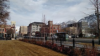
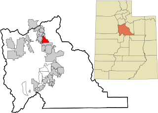
Provo is a city in and the county seat of Utah County, Utah, United States. It is 43 miles (69 km) south of Salt Lake City along the Wasatch Front, and lies between the cities of Orem to the north and Springville to the south. With a population at the 2020 census of 115,162, Provo is the fourth-largest city in Utah and the principal city in the Provo-Orem metropolitan area, which had a population of 526,810 at the 2010 census. It is Utah's second-largest metropolitan area after Salt Lake City.

<span class="mw-page-title-main">Payson, Utah</span> City in Utah, United States

Payson is a city in Utah County, Utah, United States. It is part of the Provo–Orem Metropolitan Statistical Area. The population was 21,101 at the 2020 census.

<span class="mw-page-title-main">Mormon Battalion</span> Military unit

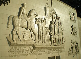
The Mormon Battalion was the only religious unit in United States military history in federal service, recruited solely from one religious body and having a religious title as the unit designation. The volunteers served from July 1846 to July 1847 during the Mexican–American War of 1846–1848. The battalion was a volunteer unit of between 534 and 559 Latter-day Saint men, led by Mormon company officers commanded by regular U.S. Army officers. During its service, the battalion made a grueling march of nearly 1,950 miles from Council Bluffs, Iowa, to San Diego, California.

<span class="mw-page-title-main">Mormon Trail</span> Migrant route from Illinois to Salt Lake City, Utah

The Mormon Trail is the 1,300-mile (2,100 km) long route from Illinois to Utah on which Mormon pioneers traveled from 1846–47. Today, the Mormon Trail is a part of the United States National Trails System, known as the Mormon Pioneer National Historic Trail.

<span class="mw-page-title-main">Mormon pioneers</span> Members of the Latter-day Saints church who moved to the western U.S. in the 1840s

The Mormon pioneers were members of the Church of Jesus Christ of Latter-day Saints, also known as Latter-day Saints, who migrated beginning in the mid-1840s until the late-1860s across the United States from the Midwest to the Salt Lake Valley in what is today the U.S. state of Utah. At the time of the planning of the exodus in 1846, the territory comprising present-day Utah was part of the Republic of Mexico, with which the U.S. soon went to war over a border dispute left unresolved after the annexation of Texas. The Salt Lake Valley became American territory as a result of the Treaty of Guadalupe Hidalgo, which ended the war.

<span class="mw-page-title-main">Maeser Elementary</span> United States historic place

Maeser Elementary was an elementary school in Provo, Utah. It was named after Karl G. Maeser. Built in 1898, it is the oldest school building in Provo, Utah. The school was designed by architect Richard C. Watkins, who also designed the Provo Third Ward Chapel and Amusement Hall, The Knight Block Building, and the Thomas N. Taylor Mansion.

Antonga, or Black Hawk, was a nineteenth-century war chief of the Timpanogos Tribe in what is the present-day state of Utah. He led the Timpanogos against Mormon settlers and gained alliances with Paiute and Navajo bands in the territory against them during what became known as the Black Hawk War in Utah (1865–1872). Although Black Hawk made peace in 1867, other bands continued raiding until the US intervened with about 200 troops in 1872. Black Hawk died in 1870 from a gunshot wound he received while trying to rescue a fallen warrior, White Horse, at Gravely Ford Richfield, Utah, June 10, 1866. The wound never healed and complications set in.

Chief Walkara was a Shoshone leader of the Utah Indians known as the Timpanogo and Sanpete Band. It is not completely clear what cultural group the Utah or Timpanogo Indians belonged to, but they are listed as Shoshone. He had a reputation as a diplomat, horseman and warrior, and a military leader of raiding parties, and in the Wakara War.

<span class="mw-page-title-main">Daniel Webster Jones (Mormon)</span> American Mormon pioneer (1830–1915)

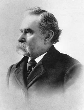
Daniel Webster Jones was an American and Mormon pioneer. He was the leader of the group that colonized what eventually became Mesa, Arizona, made the first translation of selections of The Book of Mormon into Spanish, led the first Mormon missionary expedition into Mexico, dealt frequently with the American Indians, and was the leader of the group that heroically wintered at Devil's Gate during the rescue of the stranded handcart companies in 1856.

<span class="mw-page-title-main">History of Utah</span>

The History of Utah is an examination of the human history and social activity within the state of Utah located in the western United States.

<span class="mw-page-title-main">Black Hawk War (1865–1872)</span> Part of the Ute, Apache, and Navajo Wars

The Black Hawk War, or Black Hawk's War, is the name of the estimated 150 battles, skirmishes, raids, and military engagements taking place from 1865 to 1872, primarily between Mormon settlers in Sanpete County, Sevier County and other parts of central and southern Utah, and members of 16 Ute, Southern Paiute, Apache and Navajo tribes, led by a local Ute war chief, Antonga Black Hawk. The conflict resulted in the abandonment of some settlements and hindered Mormon expansion in the region.

<span class="mw-page-title-main">Timpanogos</span> Native American tribe

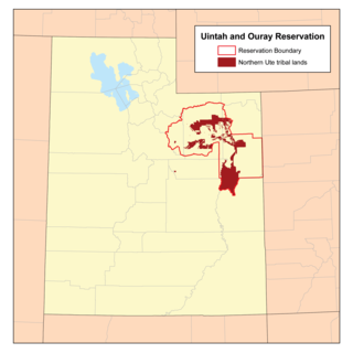
The Timpanogos are a tribe of Native Americans who inhabited a large part of central Utah, in particular, the area from Utah Lake east to the Uinta Mountains and south into present-day Sanpete County.

<span class="mw-page-title-main">Battle Creek massacre</span> 1849 massacre of Timpanogo Indians in Utah

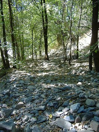
The Battle Creek massacre was a lynching of a Timpanogos group on March 5, 1849, by a group of 35 Mormon settlers at Battle Creek Canyon near present-day Pleasant Grove, Utah. It was the first violent engagement between the settlers who had begun coming to the area two years before, and was in response to reported cattle theft by the group. The attacked group was outnumbered, outgunned, and had little defense against the militia that crept in and surrounded their camp before dawn. The massacre had been ordered by Brigham Young, the Utah territory governor and president of the Church of Jesus Christ of Latter-day Saints (LDS). The formation of the Mormon settlement of Utah Valley soon followed the attack at Battle Creek. One of the young survivors from the group of 17 children, women, and men who had been attacked grew up to be Antonga Black Hawk, a Timpanogos leader in the Black Hawk War.

<span class="mw-page-title-main">Lake Point, Utah</span> City in Utah, United States

Lake Point is a city on the eastern edge of northern Tooele County, Utah, United States. It is located 17 miles southwest of Salt Lake City International Airport and 11 miles north of Tooele, Utah. At its location on the south shore of the Great Salt Lake, the city is served by Interstate 80 and Utah State Route 36.

<span class="mw-page-title-main">Johnson–Hansen House</span> Historic house in Utah, United States

The Johnson–Hansen House is a historic house located in Provo, Utah, United States, that is listed on the National Register of Historic Places.

The Battle at Fort Utah was a violent attack in 1850 in which 90 Mormon militiamen surrounded an encampment of Timpanogos families on the Provo River one winter morning, and laid siege for two days, eventually shooting between 40 and 100 Native American men and one woman with guns and a cannon during the attack as well as during the pursuit and capture of the two groups that fled the last night. One militiaman died from return fire during the siege. Of the Timpanogos people who fled in the night, one group escaped southward, and the other ran east to Rock Canyon. Both groups were captured, however, and the men were executed. Over 40 Timpanogos children, women, and a few men were taken as prisoners to nearby Fort Utah. They were later taken northward to the Salt Lake Valley and sold as slaves to church members there. The bodies of up to 50 Timpanogos men were beheaded by some of the settlers and their heads put on display at the fort as a warning to the mostly women and children prisoners inside.

<span class="mw-page-title-main">Chief Peteetneet</span> Native American clan leader and slave trader

Chief Peteetneet, or more precisely Pah-ti't-ni't, was a clan leader of a band of Timpanogos that lived near Peteetneet Creek, which was named for him, in what is now known as Payson, Utah, United States.

The Las Vegas Mission was one of the earliest European settlements in the Las Vegas Valley. It was established by missionaries for the Church of Jesus Christ of Latter-day Saints. In May 1855, at the direction of then church president Brigham Young, thirty-two missionaries were sent to evangelize among Native Americans and establish a mission outpost in the Las Vegas Valley. The mission was abandoned in December 1857 due to growing political issues revolving Mormons and the threat of Native American attacks.

Wakara's War, also known as Walker's War was a dispute between the Paiute Indians and the Mormon settlers in the Utah Valley. This war is characterized as a string of disputes and skirmishes over property and the land from July 1853 to May 1854. This war was influenced by factors such as religious differences, the slave trade, and the division of the Salt Lake Valley.

<span class="mw-page-title-main">Fort Supply (Utah Territory)</span> Ghost town in Wyoming, United States

Fort Supply was a Mormon pioneer-era fort in Green River County, Utah Territory, United States. Established in 1853 and abandoned during the Utah War of 1857, the fort served to solidify Mormon influence and control in the area, as a base for local missionary efforts, and to supply food and other provisions for pioneers headed to Salt Lake City. The site of the former fort is located near the modern-day community of Robertson, Uinta County, Wyoming, and a monument commemorating the settlement is maintained as a satellite site of Wyoming's Fort Bridger State Historic Site.

References

  1. "Chapter Twenty-Seven: Establishing a Refuge in Deseret". churchofjesuschrist.org. Salt Lake City: The Church of Jesus Christ of Latter-day Saints. 2003. Retrieved 30 Mar 2016. Fort Utah was also called Fort Provo in honor of Etienne Provot, an early French trapper.
  2. 1 2 Weiser, Kathy (Aug 2011). "Utah Forts of the Old West – Page 2". legendsofamerica.com. Archived from the original on 29 March 2016. Retrieved 30 Mar 2016.
  3. "Fort Utah". provolibrary.com. Provo City Library. Archived from the original on November 21, 2017. Retrieved 30 Mar 2016.
  4. Peace and Violence among 19th-Century Latter-day Saints
  5. Brigham Young letter to Isaac Higbee, Oct. 18, 1849, Brigham Young Office Files, Church History Library, Salt Lake City.
  6. Peace and Violence among 19th-Century Latter-day Saints
  7. Historian's Office General Church Minutes, Jan. 31, 1850, Church History Library, Salt Lake City.
  8. An account of the dialogue of the January 31 meeting can be found in BYC, Microfilm reel 80, box 47, folder 6. Brigham Young is quoted as stating: "I say go [and] kill them. . . . Tell Dimick Huntington to go and kill them—also Barney Ward—let the women and children live if they behave themselves. . . . We have no peace until the men [are] killed off—never treat the Indian as your equal." Wells's Special Order No. 2 can be found in the Utah State Archives, State Capitol, Salt Lake City, Utah Territorial Militia Correspondence, 1849–1863, ST-27, Microfilm reel 1, Document No. 5
  9. D. Robert Carter, Founding Fort Utah: Provo's Native Inhabitants, Early Explorers, and First Year of Settlement (Provo, Utah: Provo City Corporation, 2003), 52, 114–15, 135, 142, 145, 153–57, 163, 227. Contemporaneous sources indicate that the number of Indians who died was between 24 and 40, though a much later reminiscence places the death count among the Utes at around 100. (See Epsy Jane Williams, Autobiography, [1], Church History Library, Salt Lake City; and Jared Farmer, On Zion's Mount: Mormons, Indians, and the American Landscape [Cambridge, Massachusetts, and London: Harvard University Press, 2008], 67–77.)
  10. Utah Historical Quarterly Volume XLVI Open Hand and Mailed Fist: Mormon-Indian Relations in Utah, 1847–52 by Howard A. Christy
  11. Seidl, George W (August 31, 1937). "Daughters of Pioneers Dedicate Monument at Site of Old Fort Utah". The Evening Herald. Provo, Utah. Retrieved July 3, 2018.
  12. "Fort Utah Monument to Be Dedicated Monday". The Sunday Herald. Provo, Utah. August 29, 1937. Retrieved July 3, 2018.
  13. "Utah Lake Lions Plan Development of Historic Fort Utah Site As Park". The Sunday Herald. Provo, Utah. October 8, 1967. p. 3.
  14. "Fort Utah Park in Provo Taking Shape; Utah Lake Lions Club Plants Trees". The Daily Herald. Provo, Utah. April 24, 1970. p. 10.
  15. "Fort Utah Replica Nears Finish". The Sunday Herald. Provo, Utah. July 23, 1972. p. 3.
  16. "Non-Historic Fort Structure Demolition". John Curtis: Provo Insider. Provo Utah Mayor's Office. January 25, 2017. Archived from the original on February 3, 2017. Retrieved July 7, 2018.{{cite web}}: CS1 maint: unfit URL (link)
  17. Romboy, Dennis (July 27, 1998). "Is replica at site of original fort?". The Deseret News. Salt Lake City. Archived from the original on February 12, 2024. Retrieved July 3, 2018.
  18. Carter, D. Robert (July 22, 2009). "Despite hardship, Provo historians pushed for pioneer village". The Daily Herald. Provo, Utah. Archived from the original on September 1, 2015. Retrieved July 7, 2018.

Further reading

40°14′16″N111°41′20″W / 40.2379°N 111.6889°W / 40.2379; -111.6889