Utah Lake is a shallow freshwater lake in the center of Utah County, Utah, United States. It lies in Utah Valley, surrounded by the Provo-Orem metropolitan area. The lake's only river outlet, the Jordan River, is a tributary of the Great Salt Lake. Evaporation accounts for 42% of the lake's outflow, which leaves the lake slightly saline. The elevation of the lake is at 4,489 feet (1,368 m) above sea level. If the lake's water level rises above that, the pumps and gates on the Jordan River are left open. Recently the lake has been at a lower level because of a drought.

The South Saskatchewan River is a major river in the Canadian provinces of Alberta and Saskatchewan. The river begins at the confluence of the Bow and Oldman Rivers in southern Alberta and ends at the Saskatchewan River Forks in central Saskatchewan. The Saskatchewan River Forks is the confluence of the South and North Saskatchewan Rivers and is the beginning of the Saskatchewan River.

The Jordan River is a 51.4-mile-long (82.7 km) river in the U.S. state of Utah. Regulated by pumps at its headwaters at Utah Lake, it flows northward through the Salt Lake Valley and empties into the Great Salt Lake. Four of Utah's six largest cities border the river: Salt Lake City, West Valley City, West Jordan, and Sandy. More than a million people live in the Jordan Subbasin, part of the Jordan River watershed that lies within Salt Lake and Utah counties. During the Pleistocene, the area was part of Lake Bonneville.

The Sevier River is a 400-mile (640 km)-long river in the Great Basin of southwestern Utah in the United States. Originating west of Bryce Canyon National Park, the river flows north through a chain of high farming valleys and steep canyons along the west side of the Sevier Plateau before turning southwest and terminating in the endorheic basin of Sevier Lake in the Sevier Desert. It is used extensively for irrigation along its course, with the consequence that Sevier Lake is usually dry.

The Price River is a 137-mile-long (220 km) southeastward flowing river in Carbon, Utah and Emery counties in eastern Utah. It is a tributary to the Green River, itself a tributary to the Colorado River.

The June sucker is an endangered species of fish endemic to Utah Lake and the Provo River in the U.S. state of Utah. It is named after the month in which it spawns. It is a gray or brownish fish with a paler belly, growing up to about 24 in (61 cm). It lives alongside the Utah sucker, which has a much wider range. Due to the populations of both fish becoming greatly reduced in the lake as a result of fishing, other species such as the common carp have been introduced into the lake. As a result, the June sucker has become "critically endangered" as the pure species is lost as a result of hybridization with the Utah sucker, and predatory fish feed on its larvae. Conservation measures have been put in place and fish are being raised in a fish hatchery for reintroduction.

The Weber River is a c. 125-mile (201 km) long river of northern Utah, United States. It begins in the northwest of the Uinta Mountains and empties into the Great Salt Lake. The Weber River was named for American fur trapper John Henry Weber.

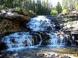
The Deer Creek Dam and Reservoir hydroelectric facilities are on the Provo River in western Wasatch County, Utah, United States, about 16 miles (26 km) northeast of Provo. The dam is a zoned earthfill structure 235 feet (72 m) high with a crest length of 1,304 ft (397 m). The dam contains 2,810,000 cubic yards of material and forms a reservoir of 152,570 acre-foot (188,190,000 m3) capacity. Construction began in May 1938 and was completed in 1941. The reservoir supplies water for agricultural, municipal, and industrial use. Recreational activities on and around the reservoir include boating, fishing, camping, swimming and water skiing.

Alameda Creek is a large perennial stream in the San Francisco Bay Area. The creek runs for 45 miles (72 km) from a lake northeast of Packard Ridge to the eastern shore of San Francisco Bay by way of Niles Canyon and a flood control channel. Along its course, Alameda Creek provides wildlife habitat, water supply, a conduit for flood waters, opportunities for recreation, and a host of aesthetic and environmental values. The creek and three major reservoirs in the watershed are used as water supply by the San Francisco Public Utilities Commission, Alameda County Water District and Zone 7 Water Agency. Within the watershed can be found some of the highest peaks and tallest waterfall in the East Bay, over a dozen regional parks, and notable natural landmarks such as the cascades at Little Yosemite and the wildflower-strewn grasslands and oak savannahs of the Sunol Regional Wilderness.

Putah Creek is a major stream in Northern California, a tributary of the Yolo Bypass, and ultimately, the Sacramento River. The 85-mile-long (137 km) creek has its headwaters in the Mayacamas Mountains, a part of the Coast Range, and flows east through two dams. First, Monticello Dam forms Lake Berryessa, below which Putah Creek forms the border of Yolo and Solano Counties, and then flows to the Putah Diversion Dam and Lake Solano. After several drought years in the late 1980s, the majority of Putah Creek went dry, prompting a landmark lawsuit that resulted in the signing of the Putah Creek Accord in 2000. The Accord established releases from the dams to maintain stream flows in Putah Creek, with natural flow regimes which spike in winter/spring and ebb in summer/fall. The restoration of natural flow regimes has resulted in a doubling of riparian bird species and a return of spawning native steelhead trout and Chinook salmon, as well as protecting the livelihood of farmers on the lower watershed.
Strawberry Reservoir is a large reservoir in the U.S. state of Utah, located on the Strawberry River. It is Utah's most popular fishery, receiving over 1.5 million angling hours annually and is part of the Blue Ribbon Fisheries program. Game fish in the reservoir include sterilized rainbow trout, bear lake cutthroat trout, kokanee salmon and crayfish. It is located 23 miles (37 km) southeast of Heber, Utah on U.S. Route 40. The reservoir is situated in Strawberry Valley. This valley is normally part of the Colorado River drainage. The dam was constructed to divert water into Utah Valley.
The Central Utah Project is a United States federal water project that was authorized for construction under the Colorado River Storage Project Act of April 11, 1956, as a participating project. In general, the Central Utah Project develops a portion of Utah's share of the yield of the Colorado River, as set out in the Colorado River Compact of 1922.

Provo Canyon is located in unincorporated Utah County and Wasatch County, Utah. Provo Canyon runs between Mount Timpanogos on the north and Mount Cascade on the south. The canyon extends from Orem on the west end to Heber City on the east. Provo Canyon is situated to the east of Utah Valley and grants access to the valleys and Uinta Basin regions that lie beyond the Wasatch front.

Deer Creek State Park a state park in south western Wasatch County, Utah, United States, featuring large Deer Creek Dam and Reservoir. The park is located near the town of Charleston in the southwest corner of the Heber Valley.

Camanche Reservoir is an artificial lake in the San Joaquin Valley in California in the United States, at the juncture of Amador, Calaveras, and San Joaquin counties. Its waters are impounded by Camanche Dam, which was completed in 1963. Camanche Reservoir is a source of water for industrial and municipal purposes and also provides flood control.
The Red Butte Creek oil spill was caused by a rupture in a medium crude oil pipeline that occurred on June 11 and 12 2010. The Chevron Pipeline (CPL) is 10 inches in diameter and runs from western Colorado to a Chevron Corporation oil refinery near Salt Lake City Utah. A half-inch diameter hole in the pipeline was caused by an electrical arc from high voltage power lines to a metal fence post buried a few inches above the pipeline.
Searsville Dam is a masonry dam in San Mateo County, California, that was completed in 1892, one year after the founding of Stanford University, and impounds Corte Madera Creek to form a reservoir known as Searsville Reservoir or Searsville Lake. Searsville Dam is located in the Jasper Ridge Biological Preserve and is owned and operated by Stanford University. Neighboring cities include Woodside and Portola Valley, California.

Trout Creek is a small tributary of the Truckee River draining about 5.1 square miles (13 km2) along the eastern crest of the Sierra Nevada. It originates east of Donner Ridge and north of Donner Lake in the Tahoe–Donner Golf Course and flows through the town of Truckee, California, to its confluence with the Truckee River in Nevada County, California, just west of Highway 267.

Pacheco Creek is a 28 miles (45 km) west by southwest flowing stream which heads in the Diablo Range in southeastern Santa Clara County and flows to San Felipe Lake, the beginning of the Pajaro River mainstem, in San Benito County, California.

The Murdock Canal, also known as the Provo Reservoir Canal and the Provo River Aqueduct, is a 23 mile water conveyance system that diverts water from the Provo River and other water storage systems to water users in Utah County. The canal starts at the Murdock Diversion Dam which is located at the mouth of Provo Canyon in Provo, Utah. The canal runs completely underground through Utah Valley and ends at the Jordan Aqueduct in Lehi, Utah. It carries water through the cities of Orem, Lindon, Pleasant Grove, Cedar Hills, American Fork, Highland, and Lehi. The canal is the largest of three primary water conveyance systems in Salt Lake Valley, the other systems being the Jordan Aqueduct and the Salt Lake Aqueduct. The water capacity of the Murdock Canal more than doubles that of either the Jordan Aqueduct or Salt Lake Aqueduct at 612 cfs.