Utah Valley

Last updated
Utah Valley
Utah Lake prove map.jpg
Satellite image of Utah Valley, 2006
Depth1,378 to 1,579 m (4,521 to 5,180 ft)
Geography
Population centers Provo
Coordinates 40°10′N111°40′W / 40.167°N 111.667°W / 40.167; -111.667
Part of the Wasatch Range forming the Utah Valley. ProvoMntns.jpg
Part of the Wasatch Range forming the Utah Valley.

Utah Valley is a valley in North Central Utah located in Utah County, and is considered part of the Wasatch Front. It contains the cities of Provo, Orem, and their suburbs, including Alpine, American Fork, Cedar Hills, Elk Ridge, Highland, Lehi, Lindon, Mapleton, Payson, Pleasant Grove, Salem, Santaquin, Saratoga Springs, Spanish Fork, Springville, Vineyard and Woodland Hills. It is known colloquially as "Happy Valley".

Contents

Geography

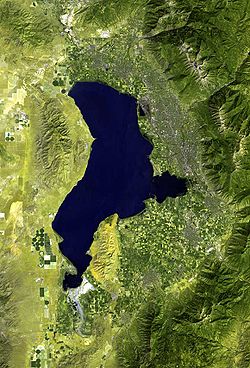
Utah Lake is a natural shallow fresh water lake in its center. All rivers in the valley flow into Utah Lake, which itself empties into the Jordan River to the north. That river flows into the Salt Lake Valley through the Jordan Narrows, a gap in the Traverse Mountains. Geographic borders of the Utah Valley are the following; The Traverse Mountains and West Traverse Mountains to the north, the Wasatch mountains to the east, Juab Pass to the south, and Goshen Pass, West Mountain, Utah Lake, the Lake Mountains, and Cedar Pass to the west.

The geography of Utah Valley combined with the prevalence of fossil fuel burning vehicles leads to poor air quality in Utah. [1]

Economy

The north part of Utah Valley is considered the center of Silicon Slopes and includes headquarters and regional offices of many prominent technology companies including Adobe, Ancestry, Entrata, Intel/Micron joint venture IM Flash, Microsoft, Oracle, SanDisk, Qualtrics, Vivint, Workfront, Xactware and housing the largest NSA data center. [2]

Education

Utah Valley University and Brigham Young University are located in Orem and Provo respectively. They are two of the largest universities in the state and represent approximately 62,000 students. [3]

Demographics

Many inhabitants of Utah Valley are members of the Church of Jesus Christ of Latter-day Saints, which operates six temples in the valley. These include the Provo Utah Temple in Provo, the Mount Timpanogos Utah Temple in American Fork, the Payson Utah Temple in Payson, the Provo City Center Temple in Provo, the Saratoga Springs Utah Temple in Saratoga Springs, and the Orem Utah Temple in Orem. The final two of which were dedicated in 2023 and 2024, respectively.

The population of Utah Valley is estimated at 575,205 by the United States Census Bureau. [4] The growth in the area has been significant. In 1970, 1980, 1994, 2009 the population was 125,005; 204,102; 277,179; and 555,551 respectively. The most populous city is Provo, [5] with a population count of 114,801 inhabitants. [6]

View of Utah Valley, 2021 View of Utah Valley.jpg
View of Utah Valley, 2021

Related Research Articles

<span class="mw-page-title-main">Utah</span> U.S. state

Utah is a landlocked state in the Mountain West subregion of the Western United States. It borders Colorado to its east, Wyoming to its northeast, Idaho to its north, Arizona to its south, and Nevada to its west. Utah also touches a corner of New Mexico in the southeast. Of the fifty U.S. states, Utah is the 13th-largest by area; with a population over three million, it is the 30th-most-populous and 11th-least-densely populated. Urban development is mostly concentrated in two areas: the Wasatch Front in the north-central part of the state, which is home to roughly two-thirds of the population and includes the capital city, Salt Lake City; and Washington County in the southwest, with more than 180,000 residents. Most of the western half of Utah lies in the Great Basin.

<span class="mw-page-title-main">Orem, Utah</span> City in Utah, United States

Orem is a city in Utah County, Utah, United States, in the northern part of the state. It is adjacent to Provo, Lindon, and Vineyard and is approximately 45 miles south of Salt Lake City.

<span class="mw-page-title-main">Juab County, Utah</span> County in Utah, United States

Juab County is a county in western Utah, United States. As of the 2020 United States Census, the population was 11,786. Its county seat and largest city is Nephi.

<span class="mw-page-title-main">Wasatch County, Utah</span> County in Utah, United States

Wasatch County is a county in the U.S. state of Utah. As of the 2020 United States Census, the population was 34,788. Its county seat and largest city is Heber City. The county was named for a Ute word meaning "mountain pass" or "low place in the high mountains".

<span class="mw-page-title-main">Utah County, Utah</span> County in Utah, United States

Utah County is the second-most populous county in the U.S. state of Utah. The county seat and largest city is Provo, which is the state's fourth-largest city, and the largest outside of Salt Lake County. As of the 2020 United States Census, the population was 665,665.

<span class="mw-page-title-main">Provo, Utah</span> City in Utah, United States

Provo is a city in and the county seat of Utah County, Utah, United States. It is 43 miles (69 km) south of Salt Lake City along the Wasatch Front, and lies between the cities of Orem to the north and Springville to the south. With a population at the 2020 census of 115,162, Provo is the fourth-largest city in Utah and the principal city in the Provo-Orem metropolitan area, which had a population of 526,810 at the 2010 census. It is Utah's second-largest metropolitan area after Salt Lake City.

<span class="mw-page-title-main">Eagle Mountain, Utah</span> City in Utah, United States

Eagle Mountain is a city in Utah County, Utah. It is part of the Provo–Orem metropolitan area. The city is located to the west as well as north of the Lake Mountains, which are west of Utah Lake. It was incorporated in December 1996 and is rapidly growing. The population was 43,623 at the 2020 census. Eagle Mountain was a town in 2000. It has since been classified as a third-class city in September 2001. In its short history, the city has become known for its rapid growth.

<span class="mw-page-title-main">Spanish Fork, Utah</span> City in Utah, United States

Spanish Fork is a city in Utah County, Utah, United States. It is part of the Provo–Orem Metropolitan Statistical Area. The 2020 census reported a population of 42,602. Spanish Fork, Utah is the 20th largest city in Utah based on official 2017 estimates from the US Census Bureau.

<span class="mw-page-title-main">Draper, Utah</span> City in Utah, United States

Draper is a city in Salt Lake and Utah counties in the U.S. state of Utah, about 20 miles (32 km) south of Salt Lake City along the Wasatch Front. As of the 2020 census, the population is 51,017, up from 7,143 in 1990.

<span class="mw-page-title-main">Wasatch Front</span> Region in Utah, United States

The Wasatch Front is a metropolitan region in the north-central part of the U.S. state of Utah. It consists of a chain of mostly contiguous cities and towns stretched along the Wasatch Range from approximately Santaquin in the south to Logan in the north, and containing the cities of Salt Lake City, Bountiful, Layton, and Ogden.

<span class="mw-page-title-main">Salt Lake Valley</span> Geographic depression in northern Utah, US, containing Salt Lake City and its suburbs

Salt Lake Valley is a 500-square-mile (1,300 km2) valley in Salt Lake County in the north-central portion of the U.S. state of Utah. It contains Salt Lake City and many of its suburbs, notably Murray, Sandy, South Jordan, West Jordan, and West Valley City; its total population is 1,029,655 as of 2010. Brigham Young said, "this is the right place," when he and his fellow Mormon settlers moved into Utah after being driven out of several states.

<span class="mw-page-title-main">Geography of Salt Lake City</span>

Salt Lake City is located in a large valley, the Salt Lake Valley, separated by the eastern Wasatch Mountains, a subrange of the Rocky Mountains, and the Oquirrh Mountains to the west. Salt Lake City is located at 40°45'17" North, 111°53'33" West.

<span class="mw-page-title-main">Alpine School District</span> Public school district in Utah County, Utah, United States

Alpine School District is the primary school district in northern Utah County, Utah, United States

<span class="mw-page-title-main">Interstate 15 in Utah</span> Section of Interstate highway in Utah, United States

Interstate 15 (I-15) runs north–south in the U.S. state of Utah through the southwestern and central portions of the state, passing through most of the state's population centers, including St. George and those comprising the Wasatch Front: Provo–Orem, Salt Lake City, and Ogden–Clearfield. It is Utah's primary and only north–south interstate highway, as the vast majority of the state's population lives along its corridor; the Logan metropolitan area is the state's only Metropolitan Statistical Area through which I-15 does not pass. In 1998, the Utah State Legislature designated Utah's entire portion of the road as the Veterans Memorial Highway.

<span class="mw-page-title-main">Provo–Orem metropolitan area</span> Metropolitan region in Utah, United States

The Provo–Orem, UT Metropolitan Statistical Area, as defined by the United States Office of Management and Budget, is an area consisting of two counties in Utah, anchored by the cities of Provo and Orem. As of the 2020 census, the MSA had a population of 671,185.

<span class="mw-page-title-main">Salt Lake City metropolitan area</span> Metropolitan area in Salt Lake and Tooele counties in Utah, United States

The Salt Lake City metropolitan area is the metropolitan area centered on the city of Salt Lake City, Utah. The Office of Management and Budget and the United States Census Bureau currently define the Salt Lake City, Utah Metropolitan Statistical Area as comprising two counties: Salt Lake and Tooele. As of the 2020 census, the MSA had a population of 1,257,936. The Salt Lake City Metropolitan Area and the Ogden-Clearfield Metropolitan Area were a single metropolitan area known as the Salt Lake City-Ogden Metropolitan Area until being separated in 2005.

<span class="mw-page-title-main">The Church of Jesus Christ of Latter-day Saints in Utah</span>

The Church of Jesus Christ of Latter-day Saints in Utah refers to the Church of Jesus Christ of Latter-day Saints and its members in Utah. Utah has more church members than any other U.S. state or country. The LDS Church is also the largest denomination in Utah.

<span class="mw-page-title-main">Lake Mountains</span> Mountain range in Utah, United States

The Lake Mountains are a 15-mile-long (24 km) mountain range located on the western edge of the Utah Valley in northwestern Utah County, Utah, United States. The range forms the northwest border of Utah Lake, and its proximity to major population centers allows its use for communication towers, mostly in its north section, bordering Eagle Mountain.

References

  1. "Pollution Sources". kued.org. KUED . Retrieved Nov 24, 2019.
  2. "NSA in Utah: Mining a mountain of data". Salt Lake Tribune. 1 July 2013. Retrieved 21 April 2016.
  3. "IPEDS". National Center for Education Statistics. Retrieved 21 April 2016.
  4. "QuickFacts: Utah County, Utah". United States Census Bureau . Retrieved 21 April 2016.
  5. Fletcher, Joe. "Vacations in Utah Valley". USA Today. Retrieved 11 September 2015.
  6. "QuickFacts: Provo city, Utah". United States Census Bureau. 2015. Retrieved 21 April 2016.