Beaver River (Utah)

Last updated
Beaver River (Utah)
Sevierrivermap.png
Map of the Sevier River system, including the Beaver River
Location
CountryUnited States
StateUtah
Physical characteristics
SourceConfluence of South and East Forks
 - location Tushar Mountains, Beaver County
 - coordinates 38°16′57″N112°26′50″W / 38.28250°N 112.44722°W / 38.28250; -112.44722 [1]
 - elevation7,142 ft (2,177 m)
Mouth Sevier River
 - location
near Delta, Millard County
 - coordinates
39°09′11″N112°50′06″W / 39.15306°N 112.83500°W / 39.15306; -112.83500 Coordinates: 39°09′11″N112°50′06″W / 39.15306°N 112.83500°W / 39.15306; -112.83500 [1]
 - elevation
4,557 ft (1,389 m)
Length110 mi (180 km) [2]
Basin size2,466 sq mi (6,390 km2) [3]
Discharge 
 - location Beaver [4]
 - average51.5 cu ft/s (1.46 m3/s) [5]
 - minimum7.2 cu ft/s (0.20 m3/s)
 - maximum1,080 cu ft/s (31 m3/s)
Basin features
Tributaries 
 - leftSouth Fork Beaver River, South Creek (Beaver River)
 - rightEast Fork Beaver River, North Creek (Beaver River), Indian Creek (Beaver River), Cove Creek

The Beaver River is a river in western Utah, 110 miles (180 km) long, that drains to Sevier Lake via the Sevier River. [2]

Utah A state of the United States of America

Utah is a state in the western United States. It became the 45th state admitted to the U.S. on January 4, 1896. Utah is the 13th-largest by area, 31st-most-populous, and 10th-least-densely populated of the 50 United States. Utah has a population of more than 3 million according to the Census estimate for July 1, 2016. Urban development is mostly concentrated in two areas: the Wasatch Front in the north-central part of the state, which contains approximately 2.5 million people; and Washington County in Southern Utah, with over 160,000 residents. Utah is bordered by Colorado to the east, Wyoming to the northeast, Idaho to the north, Arizona to the south, and Nevada to the west. It also touches a corner of New Mexico in the southeast.

Sevier Lake

Sevier Lake is an intermittent and endorheic lake which lies in the lowest part of the Sevier Desert, Millard County, Utah. Like Great Salt Lake and Utah Lake, it is a remnant of Pleistocene Lake Bonneville. Sevier Lake is fed primarily by the Beaver and Sevier rivers, and the additional inflow is from the lake's watershed that is part of the Escalante–Sevier hydrologic subregion. The lake has been mostly dry throughout recorded history and is a source of wind-blown dust.

Sevier River river in the United States of America

The Sevier River is a 385-mile (620 km)-long river in the Great Basin of southwestern Utah in the United States. Originating west of Bryce Canyon National Park, the river flows north through a chain of high farming valleys and steep canyons along the west side of the Sevier Plateau, before turning southwest and terminating in the endorheic basin of Sevier Lake in the Sevier Desert. It is used extensively for irrigation along its course, with the consequence that Sevier Lake is usually dry.

Contents

Description

The river starts in the Tushar Mountains, in eastern Beaver County near the town of Beaver, and flows for about 30 miles (48 km) west as a perennial stream, through the Beaver Valley to the Escalante Desert, where it turns north. The river then continues north for about 80 miles (130 km) as an ephemeral wash, past Milford into Millard County. Once it reaches the Sevier Desert south of Delta it turns west, joining the Sevier River and emptying into the intermittent, endorheic Sevier Lake. [2] [6]

Tushar Mountains

The Tushar Mountains are the third highest mountain range in Utah after the Uinta Mountains and the La Sal Range. Located in the Fishlake National Forest, Delano Peak, 12,174 ft  NAVD 88, is the highest point in both Beaver and Piute counties and has a prominence of 4,689 ft. Delano Peak is named for Columbus Delano (1809–1896), Secretary of the Interior during the Grant administration. The Tushars receive an ample amount of snow annually even though they are situated within the rainshadow of the Sierra Mountain Range located in California and the Snake Range located in Nevada.

Beaver County, Utah County in the United States

Beaver County is a county located in west central Utah, United States. As of the 2010 census, the population was 6,629. Its county seat and largest city is Beaver. The county was named for the abundance of beavers in the area.

Beaver, Utah Place in Utah, United States

Beaver is a city in eastern Beaver County, Utah, United States. It is also serves as the county seat. The population was 3,112 at the 2010 census. It is the county seat of Beaver County.

The Beaver River watershed drains about 2,466 square miles (6,390 km2), [3] most of it desert. The human population is about 3500, mostly concentrated in the town of Beaver. The river is dammed for irrigation in its upper reaches by Rocky Ford Dam, forming Minersville Reservoir. A total of 84,000 acres (34,000 ha) are farmed in the basin. [7]

Minersville Reservoir is a reservoir in Beaver County, Utah, United States.

See also

Related Research Articles

Little Colorado River river in the United States of America

The Little Colorado River is a tributary of the Colorado River in the U.S. state of Arizona, providing the principal drainage from the Painted Desert region. Together with its major tributary, the Puerco River, it drains an area of about 26,500 square miles (69,000 km2) in eastern Arizona and western New Mexico. Although it stretches almost 340 miles (550 km), only the headwaters and the lowermost reaches flow year-round. Between St. Johns and Cameron, most of the river is a wide, braided wash, only containing water after heavy snowmelt or flash flooding.

San Juan River (Colorado River tributary) significant tributary of the Colorado River in the southwestern United States

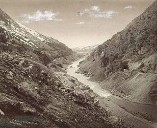
The San Juan River is a major tributary of the Colorado River in the southwestern United States, providing the chief drainage for the Four Corners region of Colorado, New Mexico, Utah and Arizona. Originating as snowmelt in the San Juan Mountains of Colorado, it flows 383 miles (616 km) through the deserts of northern New Mexico and southeastern Utah to join the Colorado River at Glen Canyon. The river drains a high, arid region of the Colorado Plateau and along its length it is often the only significant source of fresh water for many miles. The San Juan is also one of the muddiest rivers in North America, carrying an average of 25 million US tons of silt and sediment each year.

Dolores River river in the United States of America

The Dolores River is a tributary of the Colorado River, approximately 241 miles (388 km) long, in the U.S. states of Colorado and Utah. The river drains a rugged and arid region of the Colorado Plateau west of the San Juan Mountains. Its name derives from the Spanish El Rio de Nuestra Señora de Dolores, River of Our Lady of Sorrows. The river was explored and possibly named by Juan Maria Antonio Rivera during a 1765 expedition from Santa Fe.

Blue River (Colorado) tributary of the Colorado River in Colorado, USA

The Blue River is a tributary of the Colorado River, approximately 65 miles (105 km) long, in the U.S. state of Colorado.

Humboldt River river in northern Nevada in the western United States

The Humboldt River runs through northern Nevada in the western United States. At approximately 290 miles (470 km) long it is the third longest river in the Great Basin, after the Bear and Sevier Rivers. It has no outlet to the ocean, but instead empties into the Humboldt Sink. It is the fifth largest river in the United States, in terms of discharge, that does not ultimately reach the ocean, while it is the largest in terms of area drained. Through its tributaries the river drains most of sparsely populated northern Nevada, traversing the state roughly east to west, and passing through repeated gaps in the north-south running mountain ranges. It furnishes the only natural transportation artery across the Great Basin and has provided a route for historic westward migrations and subsequent railroads and highways. The river is named for the German naturalist Alexander von Humboldt.

Paria River river in southern Utah and northern Arizona

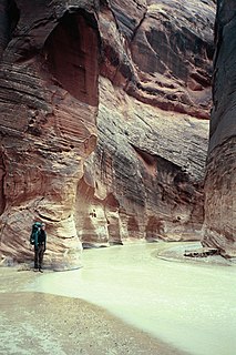
The Paria River is a tributary of the Colorado River, approximately 95 miles (153 km) long, in southern Utah and northern Arizona in the United States. It drains a rugged and arid region northwest of the Colorado, flowing through roadless slot canyons along part of its course.

Bear River (Great Salt Lake) river in southwestern Wyoming, southeastern Idaho, and northern Utah

The Bear River is the largest tributary of the Great Salt Lake, draining a mountainous area and farming valleys northeast of the lake and southeast of the Snake River Plain. It flows through southwestern Wyoming, southeastern Idaho, and northern Utah, in the United States. Approximately 350 miles (560 km) long it is the largest river in North America that does not ultimately reach the sea.

San Jacinto River (California)

The San Jacinto River is a 42-mile-long (68 km) river in Riverside County, California. The river's headwaters are in San Bernardino National Forest, but the lower portion of the 765-square-mile (1,980 km2) watershed is urban and agricultural land. As a partially endorheic watershed that is contiguous with other Great Basin watersheds, the western side of the San Jacinto Basin is a portion of the Great Basin Divide.

Sweetwater River (California) river in the United States of America

The Sweetwater River is a 55-mile (89 km) long stream in San Diego County, California.

Scott River river in Siskiyou County, California

The Scott River is a 60-mile-long (97 km) river in Siskiyou County, California, United States. It is a tributary of the Klamath River, one of the largest rivers in California.

Middle Fork Feather River river in the United States of America

The Middle Fork Feather River is a major river in Plumas and Butte Counties in the U.S. state of California. Nearly 100 miles (160 km) long, it drains about 1,062 square miles (2,750 km2) of the rugged northern Sierra Nevada range.

Middle Fork Eel River river in the United States of America

The Middle Fork Eel River is a major tributary of the Eel River of northwestern California in the United States. It drains a rugged and sparsely populated region of the Yolla Bolly Mountains, part of the California Coast Range, in Trinity and Mendocino Counties. Its watershed comprises roughly 745 square miles (1,930 km2) of land, or 20% of the entire Eel River basin. The river provides groundwater recharge and is used for recreation and for industrial, agricultural and municipal water supply by residents.

Bully Creek (Malheur River tributary) river in the United States of America

Bully Creek is a 62-mile (100 km) long tributary of the Malheur River, located in the U.S. state of Oregon. It drains 601 square miles (1,557 km2) of Malheur County. Arising in the Blue Mountains, it flows generally southeast to its confluence with the Malheur River near Vale.

North Fork Kings River river in the United States of America

The North Fork Kings River is a 40.3-mile (64.9 km) tributary of the Kings River, in the U.S. state of California. The river's main stem is entirely within Fresno County, and its watershed drains about 387 square miles (1,000 km2) of the southern Sierra Nevada mountain range.

Spanish Fork River river Utah County, Utah, United States

The Spanish Fork River or Spanish Fork is a river in the U.S. state of Utah. Formed by the confluence of Soldier Creek and Thistle Creek in the Wasatch Range, the river flows about 20 miles (32 km) northwest into Utah Lake, passing the towns of Spanish Fork and Palmyra.

North Fork Stanislaus River river in eastern California, USA

The North Fork Stanislaus River is a 31.2-mile (50.2 km) tributary of the Stanislaus River in the central Sierra Nevada and Stanislaus National Forest of eastern California.

Cow Creek (Sacramento River tributary)

Cow Creek is a tributary of the Sacramento River in Shasta County, California. About 46.9 miles (75.5 km) long measured to its longest source, it drains a hilly, rural region at the northern end of the Sacramento Valley east of Redding. The creek begins at Millville at the confluence of Old Cow and South Cow Creek and flows west to Junction, where it turns south, joining the Sacramento near Anderson. Despite its name, Cow Creek is closer in size to a river, especially in winter when it is prone to large flash floods, accounting for up to 21 percent of the Sacramento's peak flows at Red Bluff.

Willow Creek (Grand and Uintah counties, Utah)

Willow Creek is a major north-flowing stream in Utah, United States, and is a tributary of the Green River. The creek drains a large remote area of the East Tavaputs Plateau, flowing into the Green River south of Ouray.

Arroyo Grande Creek

Arroyo Grande Creek is a major stream in San Luis Obispo County on the Central Coast of California. The creek flows 22 miles (35 km) in a southwesterly direction, from the Santa Lucia Range to the Pacific Ocean. It is a major source of water supply for southern San Luis Obispo County.

References

  1. 1 2 "Beaver River". Geographic Names Information System . United States Geological Survey. 1979-12-31. Retrieved 2015-01-02.
  2. 1 2 3 Hahl, D.C.; Mundorff, J.C. (1968). "An Appraisal of the Quality of Surface Water in the Beaver River Basin, 1964" (PDF). State of Utah Department of Natural Resources, Technical Publication No. 19. Utah Division of Water Rights. Retrieved 2015-01-02.
  3. 1 2 "Boundary Descriptions and Names of Regions, Subregions, Accounting Units and Cataloging Units". United States Geological Survey. Retrieved 2015-01-02.
  4. "USGS Gage #10234500 on the Beaver River near Beaver, UT" (PDF). National Water Information System. United States Geological Survey. 1915–2013. Retrieved 2015-01-02.
  5. "USGS Gage #10234500 on the Beaver River near Beaver, UT" (PDF). National Water Information System. United States Geological Survey. 1915–2013. Retrieved 2015-01-02.
  6. USGS Topo Maps for United States (Map). Cartography by United States Geological Survey. ACME Mapper. Retrieved 2015-01-02.
  7. "Beaver River Watershed" (PDF). Improving Utah’s Water Quality. Utah State University. November 2012. Retrieved 2015-01-02.

Commons-logo.svg Media related to Beaver River (Utah) at Wikimedia Commons