
Beaver County is a county in west central Utah, United States. As of the 2010 United States Census, the population was 6,629. Its county seat and largest city is Beaver. The county was named for the abundance of beaver in the area.
Piute County is a county in south-central Utah, United States. As of the 2010 United States Census, the population was 1,556, making it the second-least populous county in Utah. The county seat is Junction, and the largest town is Circleville.

Beaver is a city in South western Beaver County, Utah, United States. It also serves as the county seat. The population was 3,112 at the 2010 census. It is the county seat of Beaver County.

Minersville is a town in southeastern Beaver County, Utah, United States. The population was 907 at the 2010 census.

Flaming Gorge Reservoir is the largest reservoir in Wyoming, on the Green River, impounded behind the Flaming Gorge Dam. Construction on the dam began in 1958 and was completed in 1964. The reservoir stores 3,788,900 acre feet (4.6735×10⁹ m3) of water when measured at an elevation of 6,040 feet (1,841 m) above sea-level (maximum).

The Weber River is a c. 125-mile (201 km) long river of northern Utah, United States. It begins in the northwest of the Uinta Mountains and empties into the Great Salt Lake. The Weber River was named for American fur trapper John Henry Weber.

The Beaver Dam Mountains Wilderness is a wilderness area located in northwestern Arizona and southwestern Utah, USA, within the arid Colorado Plateau region. The jagged mountains and gently sloping alluvial plain of the Beaver Dam Mountains straddle the border between the two states. The Wilderness contains some of the lowest elevation land in Utah, and includes a 13 miles (21 km) section of the Virgin River Gorge. The area comprises some 18,667 acres (7,554 ha), 15,000 acres (6,100 ha) of which in Arizona and approximately 3,667 acres (1,484 ha) in Utah. The area was designated Wilderness by the U.S. Congress in 1984 and is administered by the Bureau of Land Management.

Beaver Dam State Park is a public recreation area encompassing more than 2,000 acres (810 ha) along Beaver Dam Wash in Lincoln County, Nevada. The state park is on the Nevada/Utah state line about 25 miles (40 km) east of the town of Caliente.

Beaver Dam State Park is an Illinois state park on 750 acres (304 ha) in Macoupin County, Illinois in the United States. The park is 7 miles (11 km) southwest of Carlinville, Illinois and is managed by the Illinois Department of Natural Resources (IDNR) as a public place for fishing.
State Route 21 (SR-21) is a state highway in western Utah, running for 107.575 miles (173.125 km) in Millard and Beaver Counties from the Nevada state line near Garrison to Beaver.

The Beaver River is a river in western Utah, 110 miles (180 km) long, that drains to Sevier Lake via the Sevier River.

The Bull Valley Mountains are a 30-mi (48 km) long, mountain range in southwest Utah, located in northwest Washington County. The range is adjacent the Utah border and attached to the Clover Mountains of southeast Nevada. The Great Basin Divide transects the summits of both ranges, with the Escalante Desert north and northeast of the Bull Valley Mountains, and south of the mountains the Colorado River watershed, and specifically the Santa Clara River which drains southeasterly from an escarpment along the mountain range's southeast flank.
State Route 130 (SR-130) is a state highway in the U.S. state of Utah. Spanning 43 miles (69 km), it connects the town of Minersville in Beaver County with the cities of Cedar City, Enoch, and Parowan to the south in Iron County.
Adamsville is an unincorporated community in Beaver County, Utah, United States.
The Black Mountains is a 30-mile (48 km) long mountain range in northeaster Iron County and southeastern Beaver County in southwestern Utah, United States.
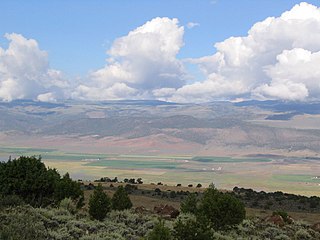
Beaver Valley is a 16-mile (26 km) long small valley located in eastern Beaver County, Utah, United States. The valley is nestled between three mountain ranges, with the Mineral Mountains at its western border, but also an outlying peak section on the mountain range northeast, forming the northern border of the valley.

The Mineral Mountains are a 28 miles (45 km) long mountain range located in eastern Beaver and southeastern Millard counties in southwestern Utah. The Escalante Desert is to its southwest, the Black Rock Desert volcanic field and the Sevier Desert are to the north and northwest. The Pavant Range and Tushar Mountains lie to the east.

Beaver Lake Mountains is an 8-mile (13 km) long mountain in central and north Beaver County, Utah, United States adjacent the south border of Millard County.
Indian Creek originally known as Sage Creek, is a tributary stream of the Beaver River in Beaver County, Utah. Its mouth is at its confluence with the Beaver River at an elevation of 5,499 feet / 1,676 meters above the Minersville Reservoir, 0.4 miles south of Adamsville. Its source is at 38°24′31″N112°26′55″W, on the northwest slope of Mount Baldy at an elevation of 10,600 feet in the Tushar Mountains.

