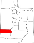
Minersville, Utah

Last updated
Minersville, Utah
Minersville Utah Town Hall.jpeg
Minersville Town Hall
Beaver County Utah incorporated and unincorporated areas Minersville highlighted.svg
Location in Beaver County and the State of Utah
Map of USA UT.svg
Location of Utah in the United States
Coordinates: 38°12′48″N112°55′30″W / 38.21333°N 112.92500°W / 38.21333; -112.92500 Coordinates: 38°12′48″N112°55′30″W / 38.21333°N 112.92500°W / 38.21333; -112.92500
CountryUnited States
State Utah
County Beaver
Area
[1]
  Total2.17 sq mi (5.63 km2)
  Land2.17 sq mi (5.63 km2)
  Water0.00 sq mi (0.00 km2)
Elevation
[2]
5,282 ft (1,610 m)
Population
 (2020)
  Total807
  Density370/sq mi (140/km2)
Time zone UTC-7 (Mountain (MST))
  Summer (DST) UTC-6 (MDT)
ZIP code
84752
Area code 435
FIPS code 49-50590 [3]
GNIS feature ID1430376 [2]

Minersville is a town in southeastern Beaver County, Utah, United States. The population was 807 at the 2020 census, [4] down from the 2010 figure of 907. [5]

Contents

History

Minersville was settled in 1859 at the direction of Brigham Young so a lead mine could be operated on the site where Jesse N. Smith and three others had found lead the previous year. [6]

Minersville had 446 residents in 1870, 525 in 1900 and in 1930 had 815 residents. [7]

Geography

Minersville is located in south-central Beaver County in mountain foothills northwest of the Black Mountains, southwest of the Mineral Mountains, and at the northeast perimeter of the Escalante Desert.

Utah State Route 21 runs through the northern side of the town, leading north 13 miles (21 km) to Milford and east 17 miles (27 km) to Beaver. Utah State Route 130 leads south from Minersville, 40 miles (64 km) to Cedar City.

According to the United States Census Bureau, the town has a total area of 0.66 square miles (1.7 km2), all land. [5]

Climate

The climate in this area has mild differences between highs and lows, and there is adequate rainfall year-round. According to the Köppen Climate Classification system, Minersville has a marine west coast climate, abbreviated "Cfb" on climate maps. [8]

Historical population
CensusPop.
1870 446
1880 4879.2%
1890 463−4.9%
1900 437−5.6%
1910 59135.2%
1920 67514.2%
1930 537−20.4%
1940 5706.1%
1950 5934.0%
1960 580−2.2%
1970 448−22.8%
1980 55223.2%
1990 60810.1%
2000 81734.4%
2010 90711.0%
2020 807−11.0%
U.S. Decennial Census [9]

Demographics

As of the census [3] of 2000, there were 817 people, 256 households, and 204 families residing in the town. The population density was 1,289.3 people per square mile (500.7/km2). There were 274 housing units at an average density of 432.4 per square mile (167.9/km2). The racial makeup of the town was 93.76% White, 0.12% Asian, 0.12% Pacific Islander, 4.16% from other races, and 1.84% from two or more races. Hispanic or Latino of any race were 6.00% of the population.

There were 256 households, out of which 49.2% had children under the age of 18 living with them, 73.0% were married couples living together, 5.1% had a female householder with no husband present, and 20.3% were non-families. 18.0% of all households were made up of individuals, and 11.7% had someone living alone who was 65 years of age or older. The average household size was 3.19 and the average family size was 3.68.

In the town, the age distribution of the population shows 39.0% under the age of 18, 10.2% from 18 to 24, 23.6% from 25 to 44, 14.4% from 45 to 64, and 12.7% who were 65 years of age or older. The median age was 26 years. For every 100 females, there were 109.5 males. For every 100 females age 18 and over, there were 100.8 males.

The median income for a household in the town was $36,563, and the median income for a family was $39,286. Males had a median income of $31,042 versus $15,179 for females. The per capita income for the town was $11,693. About 7.3% of families and 9.0% of the population were below the poverty line, including 11.3% of those under age 18 and 3.4% of those age 65 or over.

See also

Related Research Articles

<span class="mw-page-title-main">Pima, Arizona</span> Town in Graham County, Arizona

Pima is a town in Graham County, Arizona, United States. As of the 2010 census, the population of the town was 2,387, up from 1,989 in 2000. The estimated population in 2018 was 2,512. Pima is part of the Safford Micropolitan Statistical Area.

<span class="mw-page-title-main">Dayton, Idaho</span> City in Idaho, United States

Dayton is a city in Franklin County, Idaho, United States. The population was 463 at the 2010 census. It is part of the Logan, Utah-Idaho Metropolitan Statistical Area.

<span class="mw-page-title-main">Beaver, Utah</span> City in Utah, United States

Beaver is a city in, and county seat of, Beaver County in southwestern Utah, United States. The population was 3,592 at the 2020 census, up from the 2010 figure of 3,112.

<span class="mw-page-title-main">Milford, Utah</span> City in Utah, United States

Milford is a city in Beaver County, Utah, United States. The population was 1,431 at the 2020 census, up from the 2010 figure of 1,409.

<span class="mw-page-title-main">Cornish, Utah</span> Town in the state of Utah, United States

Cornish is a town in Cache County, Utah, United States. The population was 288 at the 2010 census. It is included in the Logan, Utah-Idaho (partial) Metropolitan Statistical Area.

<span class="mw-page-title-main">Hyrum, Utah</span> City in Utah, United States

Hyrum is a city in Cache County, Utah, United States. The population was 7,609 at the 2010 census, with an estimated population of 8,403 in 2018. It is included in the Logan, Utah–Idaho (partial) Metropolitan Statistical Area.

<span class="mw-page-title-main">Newton, Utah</span> Town in the state of Utah, United States

Newton is a town in Cache County, Utah, United States. It was founded in 1869 by pioneers of the Church of Jesus Christ of Latter-day Saints. The population was 789 at the 2010 census. It is included in the Logan, Utah-Idaho Metropolitan Statistical Area.

<span class="mw-page-title-main">Centerville, Utah</span> City in Utah, United States

Centerville is a city in southeastern Davis County, Utah, United States. Centerville is part of the Ogden-Clearfield Metropolitan Statistical Area. The population was 15,335 at the 2010 census. It is located adjacent to the easternmost part of the Great Salt Lake.

<span class="mw-page-title-main">Clinton, Utah</span> City in Utah, United States

Clinton is a city in Davis County, Utah, United States. It is part of the Ogden–Clearfield, Utah Metropolitan Statistical Area. The population was 23,386 at the 2020 United States census, up from 20,426 in 2010 census. Clinton started off as a sleepy farm town and grew rapidly during the 1990s and continues to experience rapid growth, with an estimated population of 23,597 in 2021.

<span class="mw-page-title-main">Clawson, Utah</span> Town in the state of Utah, United States

Clawson is a town in Emery County, Utah, United States. The population was 163 at the 2010 census. The community was named after Rudger Clawson, a Mormon leader.

<span class="mw-page-title-main">Hinckley, Utah</span> Town in the state of Utah, United States

Hinckley is a town in Millard County, Utah, United States, in the middle of the Sevier Desert. Irrigation water from the Sevier River, passing nearby, has been used to turn Hinckley into a farming oasis. The mountains that are common in Utah are seen only in the distance, and beyond the reach of the river, a severe desert prevails. The population was 696 at the 2010 census.

<span class="mw-page-title-main">Lynndyl, Utah</span> Town in the state of Utah, United States

Lynndyl is a town in Millard County, Utah, United States. The population was 106 at the 2010 census.

<span class="mw-page-title-main">Meadow, Utah</span> Town in the state of Utah, United States

Meadow is a town in Millard County, Utah, United States. The population was 254 at the 2000 census. Originally called Meadow Creek, the town is located about eight miles south of Fillmore.

<span class="mw-page-title-main">Scipio, Utah</span> Town in the state of Utah, United States

Scipio is a town on the eastern edge of Millard County, Utah, United States. The population was 290 at the 2000 census.

<span class="mw-page-title-main">Circleville, Utah</span> Town in the state of Utah, United States

Circleville is a town in Piute County, Utah, United States. The population was 547 at the 2010 census.

<span class="mw-page-title-main">Mayfield, Utah</span> Town in the state of Utah, United States

Mayfield is a town in southwestern Sanpete County, Utah, United States. The population was 496 at the 2010 census.

<span class="mw-page-title-main">Moroni, Utah</span> City in Utah, United States

Moroni is a city in Sanpete County, Utah, United States. The population was 1,423 at the 2010 census.

<span class="mw-page-title-main">Joseph, Utah</span> Town in the state of Utah, United States

Joseph is a town in Sevier County, Utah, United States. The population was 269 at the 2000 census. The town was named for Joseph Angell Young, an apostle of the Church of Jesus Christ of Latter-day Saints. Joseph was settled in 1871.

<span class="mw-page-title-main">Daniel, Utah</span> Town in Utah, United States

Daniel is a town in Wasatch County, Utah, United States. The population was 938 at the 2010 census, at which time it was a township and census-designated place (CDP). Daniel incorporated as a town in February 2006. Daniel was first settled in 1874.

<span class="mw-page-title-main">Huntsville, Utah</span> Town in the state of Utah, United States

Huntsville is a town in Weber County, Utah, United States. The population was 608 at the 2010 census. It is located in Ogden Valley. It is part of the Ogden–Clearfield, Utah Metropolitan Statistical Area, as well as the Ogden Valley census county division.

References

  1. "2019 U.S. Gazetteer Files". United States Census Bureau. Retrieved August 7, 2020.
  2. 1 2 U.S. Geological Survey Geographic Names Information System: Minersville
  3. 1 2 "U.S. Census website". United States Census Bureau . Retrieved 2008-01-31.
  4. "2020 Census Redistricting Data: Minersville town, Utah". Census Data Explorer. United States Census Bureau. September 16, 2021. Retrieved January 28, 2023.
  5. 1 2 "Geographic Identifiers: 2010 Demographic Profile Data (G001): Minersville town, Utah". United States Census Bureau, American Factfinder. Archived from the original on February 12, 2020. Retrieved April 23, 2014.
  6. Andrew Jenson. Encyclopedic History of the Church. (Salt Lake City: Deseret Book, 1941) p. 512
  7. Jenson. Encyclopedic History. p. 512
  8. Climate Summary for Minersville, Utah
  9. "Census of Population and Housing". Census.gov. Retrieved June 4, 2015.