The Bingham Canyon Mine, more commonly known as Kennecott Copper Mine among locals, is an open-pit mining operation extracting a large porphyry copper deposit southwest of Salt Lake City, Utah, in the Oquirrh Mountains. The mine is the largest man-made excavation, and deepest open-pit mine in the world, which is considered to have produced more copper than any other mine in history – more than 19 million tons. The mine is owned by Rio Tinto Group, a British-Australian multinational corporation. The copper operations at Bingham Canyon Mine are managed through Kennecott Utah Copper Corporation which operates the mine, a concentrator plant, a smelter, and a refinery. The mine has been in production since 1906, and has resulted in the creation of a pit over 0.75 miles (1,210 m) deep, 2.5 miles (4 km) wide, and covering 1,900 acres. It was designated a National Historic Landmark in 1966 under the name Bingham Canyon Open Pit Copper Mine. The mine experienced a massive landslide in April 2013 and a smaller slide in September 2013.

Mercur is a historical hard rock mining ghost town in Tooele County, Utah, United States. In 1891, it became the site of the first successful use of the cyanide process of gold extraction in the United States, the dominant metallurgy today. Its elevation above sea level is approximately 2,042 m. The nearby Mercur Gold Mine was re-opened by Barrick Gold in 1985, with mining operations again coming to an end in 1997. The reclamation and restoration project was set to continue up to 2010.

Frisco is a ghost town in Beaver County, Utah, United States. It was an active mining camp from 1879 to 1929. At its peak in 1885, Frisco was a thriving town of 6,000 people.

Kimberly is a ghost town in the northwest corner of Piute County, Utah, United States. Located high in Mill Canyon on the side of Gold Mountain in the Tushar Mountains, Kimberly was formerly a gold mining town. Originally settled in the 1890s, it lasted until 1910. Kimberly had a minor rebirth in the 1930s, but has been uninhabited since approximately 1938. The town is perhaps best known as the birthplace of Ivy Baker Priest, a former United States Treasurer.
Mammoth is an unincorporated community and semi-ghost town in northeastern Juab County, Utah, United States.

Colton is a ghost town located near the southeastern edge of Utah County, Utah, United States, approximately 6 miles (9.7 km) south of Soldier Summit. Formerly a busy railroad junction on the Denver and Rio Grande Western Railroad, Colton is a landmark on U.S. Route 6 between the cities of Spanish Fork and Price.
Scranton is a ghost town in Tooele County, Utah, United States. Located in Barlow Canyon near the Juab County line, it was a short-lived mining town. Scranton has been uninhabited for over a century, but some of its ruins have survived relatively intact.
La Plata is a ghost town on the southern end of Cache County, Utah, United States. Located in the Bear River Mountains on a small tributary of the east fork of the Little Bear River, La Plata was a short-lived silver mining boomtown in the 1890s.
Alunite is a ghost town located some 5 miles (8.0 km) south of Marysvale, near the mouth of Cottonwood Canyon in Piute County, Utah, United States. A small but important mining town during World War I, Alunite was inhabited from approximately 1915–1930.

Forest City is a ghost town in Utah County, Utah, United States. It is located in the valley of Dutchman Flat in the upper part of American Fork Canyon, in the Uinta National Forest. A silver mining town just over the mountain from Alta, Forest City was inhabited about 1871–1880. The town grew up around the smelter that was built to process ore from the canyon's mines. The American Fork Railroad, which was intended to serve Forest City and the smelter, stopped short of its destination due to engineering difficulties. Transportation costs rose too high for the mines to continue operating profitably. As the smelter, mines, and railroad closed down, Forest City was abandoned.

Sego is a ghost town in Grand County, Utah, United States. It lies in the narrow, winding Sego Canyon, in the Book Cliffs some 5 miles (8.0 km) north of Thompson Springs. Formerly an important eastern Utah coal mining town, Sego was inhabited about 1910–1955. The town is accessed via the grade of the Ballard & Thompson Railroad, a spur from the Denver and Rio Grande Western built by the founders of the town to transport the coal.

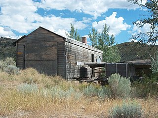
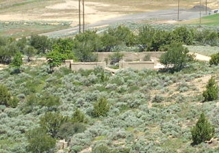
Newhouse is a ghost town located on the eastern edge of the Wah Wah Valley in Beaver County, Utah, United States. A silver mining town based on the Cactus Mine on the western slopes of the San Francisco Mountains, Newhouse was smaller and quieter than Frisco, 5 miles (8.0 km) to the southeast.

Clear Creek is a census-designated place on the western edge of Carbon County, Utah, United States. It is located at the south end of State Route 96 and the Pleasant Valley Branch of the Union Pacific Railroad (ex-D&RGW).
Grass Creek is a ghost town in Summit County, Utah, United States. Lying some 8 miles (13 km) northeast of Coalville, it was once an important coal mining town. Grass Creek was inhabited circa 1860–1940.

Silver City is a ghost town located at the mouth of Dragon Canyon on the west flank of the East Tintic Mountains in northeast Juab County in central Utah, United States. It was a silver mining town approximately 90 miles (140 km) south-southwest of Salt Lake City. This area was considered part of the Tintic Mining District and also produced bismuth, copper, gold, and lead. Settlement began with the first mining strikes here in 1869. Silver City was inhabited until 1930, after the mines played out. Jesse Knight, known as the "Mormon Wizard" for his ability to find ore easily, decided to build a smelter in Silver City because it had the flattest ground in all of the Tintic Mining District. Silver City had several mines in 1890, but the mines hit water and were abandoned. Now there is little left other than a few holes where mines were, and a number of tailings piles. The Silver City Cemetery, however, survives and is listed on the National Register of Historic Places.
Knightsville is a ghost town located in the East Tintic Mountains on the northern slope of Godiva Mountain, approximately 2 miles (3.2 km) east of Eureka, in the northeastern corner of Juab County in central Utah, United States. A silver mining camp, Knightsville was established and operated as a company town by local mining entrepreneur Jesse Knight. The town was inhabited from 1896 until approximately 1940.
The American Fork Railroad was a 16 miles (30 km) long narrow gauge railway with a gauge of 3 ft from American Fork to Forest City in Utah, which operated from 1872 to 1878.
Coal City is a ghost town in Carbon County, Utah, United States. Established in 1885, Coal City was initially a farming community until coal was discovered in the area. Small-scale mining began to take place, and because the mining operations were a mile or two away from the mines at National and Consumers, it was assumed that the citizens of the town would lack workplace stress. Coal production began to decline in 1935, and the town was essentially abandoned with just two residences occupied by the late 1960s.
Dragon is a ghost town in Uintah County, at the extreme eastern edge of Utah, United States. Founded in about 1888 as a Gilsonite mining camp, Dragon boomed in the first decade of the 20th century as the end-of-line town for the Uintah Railway. Although it declined when the terminus moved farther north in 1911, Dragon survived as the largest of the Gilsonite towns. It was abandoned after its mining operations stopped in 1938 and the Uintah Railway went out of business in 1939.

Spring Canyon, also called Storrs, is a ghost town in Carbon County, Utah, United States. In 1912, Jesse Knight purchased 1,600 acres of coal land and began developing a mine and a company town. Knight named the town Storrs, after the mine superintendent. The name of the town was changed to Spring Canyon in 1924. 1,000 tons of coal per day were mined from 1924 to 1943, and during World War II, coal production peaked at 2,000 tons of coal per day. By 1946, the need for coal diminished, and people began to leave. By 1969, Spring Canyon was abandoned.