American Fork (river)

Last updated
American Fork
Americanforkriver.jpg
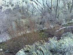
The American Fork near the mouth of American Fork Canyon, March 2007
USA Utah relief location map.svg
Red pog.svg
Location of American Fork River
Usa edcp relief location map.png
Red pog.svg
American Fork (river) (the United States)
EtymologyTo differentiate from the Spanish Fork; or derived from a company name.
Location
CountryUnited States
State Utah
County Utah
Physical characteristics
SourceUnnamed stream flowing through the American Fork Canyon
  coordinates 40°25′54″N111°38′12″W / 40.43167°N 111.63667°W / 40.43167; -111.63667 [1]
Mouth Utah Lake
  location
south of American Fork (city)
  coordinates
40°20′33″N111°45′36″W / 40.34250°N 111.76000°W / 40.34250; -111.76000 Coordinates: 40°20′33″N111°45′36″W / 40.34250°N 111.76000°W / 40.34250; -111.76000 [1]
  elevation
4,495 feet (1,370 m)
Basin features
Progression Utah Lake Jordan River Great Salt Lake

The American Fork (commonly known as the American Fork River) is a river in Utah County, Utah, United States. [1]

Contents

Description

The river rises at the mouth of American Fork Canyon in the Wasatch Mountains about 35 miles (56 km) southeast of Salt Lake City. The unnamed stream, which is the source of the American Fork, flows from Mineral Basin, through the length of the American Fork Canyon and has several named tributaries (Silver Creek, Deer Creek, and Cattle Creek). The river runs through northern Utah County and empties into Utah Lake on its north shore.

The city of American Fork is named after this river. [2] The description "American" in the river's name is to distinguish it from the Spanish Fork (river) that also originates in the Wasatch Range; alternatively, it could have been named after the American Fur Company. [3]

Fly fishermen commonly target smaller rainbow trout (measuring 6–12 in.) – and to a lesser extent brown trout – in the river during summer and fall, when strong runoff and snowfall do not limit access.

In addition to fish, a rich community of mayflies, stoneflies, and caddisflies is also present in the American Fork river. [4]

Groundwater contribution of metals to the river

The abandoned Pacific Mine adjacent to the North Fork of the river has been a source of metals that enter the river when it is gaining stream. [5] Spill events contributing toxic metals to the river have deemed waters dangerous to humans at times, [6] but work has also been done by the U.S. Forest Service to remove tailings from mining sites. [7]

See also

Related Research Articles

<span class="mw-page-title-main">Wasatch Range</span> Mountain range in Utah, United States

The Wasatch Range or Wasatch Mountains is a mountain range in the western United States that runs about 160 miles (260 km) from the Utah-Idaho border south to central Utah. It is the western edge of the greater Rocky Mountains, and the eastern edge of the Great Basin region. The northern extension of the Wasatch Range, the Bear River Mountains, extends just into Idaho, constituting all of the Wasatch Range in that state.

<span class="mw-page-title-main">Jordan River (Utah)</span> River feeding the Great Salt Lake, USA

The Jordan River, in the state of Utah, United States, is a river about 51 miles (82 km) long. Regulated by pumps at its headwaters at Utah Lake, it flows northward through the Salt Lake Valley and empties into the Great Salt Lake. Four of Utah's six largest cities border the river: Salt Lake City, West Valley City, West Jordan, and Sandy. More than a million people live in the Jordan Subbasin, part of the Jordan River watershed that lies within Salt Lake and Utah counties. During the Pleistocene, the area was part of Lake Bonneville.

<span class="mw-page-title-main">Carson River</span> River in Nevada, United States

The Carson River is a northwestern Nevada river that empties into the Carson Sink, an endorheic basin. The main stem of the river is 131 miles (211 km) long although the addition of the East Fork makes the total length 205 miles (330 km), traversing five counties: Alpine County in California and Douglas, Storey, Lyon, and Churchill Counties in Nevada, as well as the Consolidated Municipality of Carson City, Nevada. The river is named for Kit Carson, who guided John C. Frémont's expedition westward up the Carson Valley and across Carson Pass in winter, 1844. The river made the National Priorities List (NPL) on October 30, 1990 as the Carson River Mercury Superfund site (CRMS) due to investigations that showed trace amounts of mercury in the wildlife and watershed sediments.

<span class="mw-page-title-main">Sevier River</span> River in central Utah, United States

The Sevier River is a 400-mile (640 km)-long river in the Great Basin of southwestern Utah in the United States. Originating west of Bryce Canyon National Park, the river flows north through a chain of high farming valleys and steep canyons along the west side of the Sevier Plateau before turning southwest and terminating in the endorheic basin of Sevier Lake in the Sevier Desert. It is used extensively for irrigation along its course, with the consequence that Sevier Lake is usually dry.

<span class="mw-page-title-main">Animas River</span> Tributary of the San Juan River in the US states of Colorado and New Mexico

Animas River is a 126-mile-long (203 km) river in the western United States, a tributary of the San Juan River, part of the Colorado River System.

<span class="mw-page-title-main">Oquirrh Mountains</span> Mountain range in Utah, USA

The Oquirrh Mountains is a mountain range that runs north-south for approximately 30 miles (50 km) to form the west side of Utah's Salt Lake Valley, separating it from Tooele Valley. The range runs from northwestern Utah County–central & eastern Tooele County, to the south shore of the Great Salt Lake. The highest elevation is Flat Top Mountain at 10,620 ft. The name Oquirrh was taken from the Goshute word meaning "wood sitting."

<span class="mw-page-title-main">Little Cottonwood Canyon</span> Canyon in Northern Utah

Little Cottonwood Canyon lies within the Wasatch-Cache National Forest along the eastern side of the Salt Lake Valley, roughly 15 miles from Salt Lake City, Utah. The canyon is part of Granite, a CDP and "Community Council" designated by Salt Lake County. The canyon is a glacial trough, carved by an alpine glacier during the last ice age, 15,000 to 25,000 years ago. A number of rare and endemic plant species are found in the canyon's Albion Basin. Mountain goats inhabit the surrounding mountains.

<span class="mw-page-title-main">Price River</span> River in Utah, United States

The Price River is a 137-mile-long (220 km) southeastward flowing river in Carbon, Utah and Emery counties in eastern Utah. It is a tributary to the Green River, itself a tributary to the Colorado River.

<span class="mw-page-title-main">Lone Peak Wilderness</span> Wilderness area in Utah and Salt Lake counties in Utah, United States

The Lone Peak Wilderness is a 30,088-acre (121.76 km2) wilderness area located within the Uinta and the Wasatch-Cache National Forest in the U.S. state of Utah.

<span class="mw-page-title-main">Millcreek Canyon (Salt Lake County, Utah)</span>

Millcreek Canyon is a canyon in the Wasatch Mountains and part of Millcreek City on the east side of the Salt Lake Valley, Utah. It is a popular recreation area both in the summer and in the winter. It was named by Brigham Young on August 22, 1847, before all of the mills that were built in and below the densely forested canyon. It is home to two restaurants and six Boy Scout Day Camps.

<span class="mw-page-title-main">American Fork Railroad</span>

The American Fork Railroad was a 16-mile (26 km) long 3 ft narrow gauge railway from American Fork to Forest City in Utah, which operated from 1872 to 1878.

<span class="mw-page-title-main">Duchesne River</span> River in Utah, United States

The Duchesne River, located in the Uintah Basin region of Utah in the western United States, is a tributary of the Green River. The watershed of the river covers the Northeastern corner of Utah. The Duchesne River is 115 miles (185 km) long, and drains a total land area of 3,790 square miles (9,800 km2).

<span class="mw-page-title-main">Little Cottonwood Creek (Salt Lake County, Utah)</span> River in Utah, United States

Little Cottonwood Creek is one of the principal streams entering Salt Lake Valley from the east. The creek rises near the summit of the Wasatch Mountains, a short distance south of the ski resort town of Alta, and flows in a westerly direction through Little Cottonwood Canyon until it emerges into Salt Lake Valley about eleven miles from its source. Thence its course is north westerly through Sandy, Midvale and Murray, Utah until it empties into the Jordan River, about six miles south of Salt Lake City. Its whole length is nearly 27 miles (43 km). The headwaters of Little Cottonwood Creek are in Little Cottonwood Canyon, a glaciated canyon in Uinta-Wasatch-Cache National Forest and the Wasatch and Uinta Mountains eco-region. One of the main tributaries of the creek rises in Cecret Lake, a small sheet of water situated near Alta. The entire Little Cottonwood Creek drainage basin encompasses 46 square miles (120 km2), ranging in elevation from about 4,490 to 11,500 feet.

<span class="mw-page-title-main">Big Cottonwood Creek</span> River in Utah, United States

Big Cottonwood Creek is located in the Wasatch Mountains just east of Salt Lake City. It is part of the Big Cottonwood Creek Watershed, which ranges in elevation from 5,000 to 10,500 feet with the headwaters around 9,600 feet. The creek flows through the Big Cottonwood Canyon in a westerly direction until it emerges into Salt Lake Valley about eighteen miles (29 km) from its highest source. Thence its course is northwesterly through Cottonwood Heights, Holladay, and Murray, Utah for a little over twenty-four miles miles from the headwaters until it empties into the Jordan River about five miles (8.0 km) south of Salt Lake City. The water eventually flows into the Great Salt Lake. In the summer, its waters are all used for irrigation purposes. From its source to its original outlet in the Jordan River is about twenty-six miles.

<span class="mw-page-title-main">Red Butte Creek (Salt Lake County, Utah)</span> Natural watercourse in Salt Lake County, Utah, United States

Red Butte Creek is a small stream whose headwaters are found in the northeast part of Salt Lake County, Utah, United States. It flows west through the Red Butte Garden and Arboretum, by the University of Utah, Fort Douglas and flows southwesterly to Salt Lake City’s Liberty Park. Despite 7.25 sq mi (18.8 km2) of the watershed, Red Butte Canyon is the smallest canyon of the seven canyons in eastern Salt Lake County. Its elevation ranges from 5,000 to 8,000 ft above sea level.

Days Canyon is a canyon in the Wasatch Range in eastern Utah County, Utah, United States.

Hobble Creek is a stream in Utah County, Utah. Its mouth lies at at its confluence with Utah Lake, at an elevation 4,491 feet (1,369 m). Its source is located at 40°09′45″N111°30′03″W, at the confluence of the Left Fork and Right Fork Hobble Creek in the Wasatch Range. The source lies at an elevation 5,043 feet (1,537 m). The unincorporated community of Hobble Creek occupies the valley of the creek and its Left Fork.

<span class="mw-page-title-main">White River (Price River tributary)</span> River in Utah, United States

The White River is a 8-mile-long (13 km) southeastward flowing river in Wasatch and Utah Counties in eastern Utah. The White River is tributary to the Price River, which is, in turn, tributary to the Green River, and then to the Colorado River.

Birch Creek is a northwesterly-flowing 8.4 miles (13.5 km) stream in Beaver County, Utah. It originates on the western slope of Birch Creek Mountain in the Tushar Mountains in Fishlake National Forest, and its waters flow west into South Creek, then under Interstate 15 south of the town of Beaver, and thence to the Beaver River, and ultimately to the Sevier River and Lake.

References

  1. 1 2 3 U.S. Geological Survey Geographic Names Information System: American Fork
  2. "American Fork City - American Fork Utah". Archived from the original on 2008-12-24. Retrieved 2008-12-24.
  3. "Place Names on the Uinta National Forest". USDA Forest Service. it was named to avoid confusion with the Spanish Fork River to the south, another [source claims] that it was named by early trappers and mountain men who worked the creek for beaver in the early 1800s, in reference to the American Fur Company.
  4. Judson, S.W., Nelson, C.R. (December 2010). Provo, UT: Monte L. Bean Life Science Museum, Brigham Young University. DIVERSITY, PHENOLOGY, AND ELEVATIONAL DISTRIBUTION OF EPHEMEROPTERA, PLECOPTERA, AND TRICHOPTERA IN AMERICAN FORK CANYON, UTAH. Retrieved from https://www.jstor.org/stable/pdf/41718097.pdf
  5. Lachmar, T.E., Burk, N.I. & Kolesar, P.T. Groundwater Contribution of Metals from an Abandoned Mine to The North Fork of The American Fork River, Utah. Water Air Soil Pollut 173, 103–120 (2006). https://doi.org/10.1007/s11270-005-9031-8
  6. May 11, 2017 3:10. Nine months after the toxic spill, American Fork was deemed no longer dangerous. The Salt Lake Tribune. Retrieved February 24, 2022, from https://archive.sltrib.com/article.php?id=5276678&itype=CMSID
  7. Lachmar, T.E., McDonough, H.L., Burk, N.I. et al. Effect of Ore Mineralogy and Bedrock Lithology on Metal Loading Rates and Acid-Mine Drainage: Bayhorse Creek, Idaho and the North Fork of the American Fork River, Utah. Mine Water Environ 38, 3–15 (2019). https://doi.org/10.1007/s10230-018-00574-1

Commons-logo.svg Media related to American Fork (river) at Wikimedia Commons