Related Research Articles

Millard County is a county in the U.S. state of Utah. As of the 2020 United States Census, the population was 12,975. Its county seat is Fillmore, and the largest city is Delta.

Beaver is a city in, and county seat of, Beaver County in southwestern Utah, United States. The population was 3,592 at the 2020 census, up from the 2010 figure of 3,112.

Fillmore is a city and the county seat of Millard County, Utah, United States. The population was 2,592 at the 2020 United States Census. It is named for the thirteenth U.S. President Millard Fillmore, who was in office when Millard County was created by the Utah Territorial legislature.

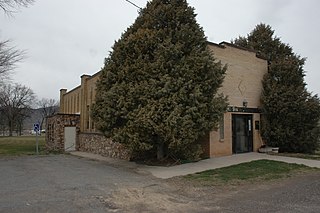
Kanosh is a town in Millard County, Utah, United States. The population was 474 at the 2010 census.
Scipio is a town on the eastern edge of Millard County, Utah, United States. The population was 290 at the 2000 census.
George Albert Smith was an early leader in the Latter Day Saint movement. He served in the Quorum of the Twelve Apostles and as a member of the First Presidency of the Church of Jesus Christ of Latter-day Saints.

St. Thomas, Nevada is a ghost town in Clark County, Nevada, United States, near where the Muddy River flows into the Colorado River. St. Thomas was purchased by the US Federal Government and abandoned as the waters of Lake Mead submerged the town in the 1930s.

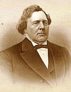
Kanosh was a nineteenth-century leader of the Pahvant band of the Ute Indians of what is now central Utah having succeeded the more belligerent Chuick as principal chief. His band had "a major camp at Corn Creek." He is remembered for having been "friendly toward early Mormon Pioneer settlers."
McCornick is an unincorporated community and near-ghost town located in Millard County, Utah, United States. Lying in Whiskey Creek Flat 11 miles (18 km) northwest of Holden, McCornick was a failed land development project that lasted from 1919 until circa 1930. Today, McCornick is made up of a few scattered homes and farms.

The Paiute Indian Tribe of Utah is a federally recognized tribe of Southern Paiute and Ute Indians in southwestern Utah.
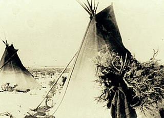
The Pahvant or Pahvants were a band of Ute people that lived in present-day Utah. Called the "Water People", they fished and hunted waterfowl. They were also farmers and hunter-gatherers. In the 18th century they were known to be friendly and attentive, but after a chief's father was killed by emigrating white settlers, a group of Pahvant Utes killed John Williams Gunnison and seven of his men during his exploration of the area. The bodies of water of their homeland were dried up after Mormons had diverted the water for irrigation. Having intermarried with the Paiutes, they were absorbed into the Paiute Indian Tribe of Utah and relocated to reservations.

The Black Rock Desert volcanic field in Millard County, Utah, is a cluster of several volcanic features of the Great Basin including Pahvant Butte, The Cinders, and Tabernacle Hill. The field's Ice Springs event was an explosive eruption followed by lava flows that were Utah's most recent volcanic activity. which overlapped the older flows of Pavant Butte.
Wild Goose Creek, originally known as Cedar Creek to the early travelers on the Mormon Road, is a stream, in Millard County, Utah. Its mouth is located at Holden at an elevation of 5,125 feet. Its source is at the head of Wild Goose Canyon, at elevation of 8,720 feet at 39°06′45″N112°07′13″W in the Pahvant Range.
Chalk Creek is a stream in Millard County, Utah, United States.
Meadow Creek is a stream in Millard County, Utah. It was originally known as 4th Creek south of Sevier River to the early travelers on the Mormon Road. Its mouth is located at an elevation of 4,842 feet or 1,476 meters. Its source is located an elevation of 9,760 feet, at 38°51′50″N112°14′16″W near the summit of White Pine Peak in the Pahvant Range. Meadow is located north of the mouth of the stream.
Corn Creek, also called Kanosh Creek, is a stream in Millard County, Utah. Its mouth is located in the Pahvant Valley. Its source is at the confluence of East Fork Corn Creek and West Fork Corn Creek in the Pahvant Range.
Cove Creek is a stream in Beaver County and Millard County, Utah. It originates at the head of its canyon southeast of Cove Fort at 38°38′09″N112°29′34″W in Beaver County. It drains north down through the Tushar Mountains then turns west at the foot of Sulphur Peak running between the south end of the Pavant Range and the Tushar Mountains, past Cove Fort, from which it received its name. It then runs west past the north end of the Mineral Mountains to disappear into the sands of the desert at Beaver Bottoms.
Corn Creek Indian Farm was a farm established in 1855 for the Pahvant Utes on Corn Creek in Millard County, Utah. It was located just downstream from the Pahvant village of Kanosh. It was abandoned in 1867.
Benmore is a ghost town in Tooele County, in the U.S. state of Utah.
References
- 1 2 U.S. Geological Survey Geographic Names Information System: Hatton
- ↑ Edward Leo Lyman, Chief Kanosh: Champion of Peace and Forbearance, Journal of Mormon History, Vol. 35, No. 1 (Winter 2009), pp. 157-207
- ↑ Edward Leo Lyman, Linda King Newell, A History Of Millard County, Utah State Historical Society, Millard County Commission, 1999
- ↑ John W. Van Cott, Utah Place Names: A Comprehensive Guide to the Origins of Geographic Names: a Compilation, University of Utah Press, Salt Lake City, 1990.
38°50′20″N112°27′24″W / 38.83889°N 112.45667°W
Municipalities and communities of Millard County, Utah, United States | ||
|---|---|---|
| Cities |  | |
| Towns | ||
| CDPs | ||
| Unincorporated communities | ||
| Ghost towns | ||
| Indian reservation | ||
| Footnotes | ‡This populated place also has portions in an adjacent county or counties | |