
A gold rush or gold fever is a discovery of gold—sometimes accompanied by other precious metals and rare-earth minerals—that brings an onrush of miners seeking their fortune. Major gold rushes took place in the 19th century in Australia, Greece, New Zealand, Brazil, Chile, South Africa, the United States, and Canada while smaller gold rushes took place elsewhere.

Calico is a ghost town and former mining town in San Bernardino County, California, United States. Located in the Calico Mountains of the Mojave Desert region of Southern California, it was founded in 1881 as a silver mining town, and was later converted into a county park named Calico Ghost Town. Located off Interstate 15, it lies 3 miles (4.8 km) from Barstow and 3 miles from Yermo. Giant letters spelling CALICO are visible, from the highway, on the Calico Peaks behind it. Walter Knott purchased Calico in the 1950s, and rebuilt all but the five remaining original buildings to look as they did in the 1880s. Calico received California Historical Landmark #782, and in 2005 was proclaimed by then-Governor Arnold Schwarzenegger to be California's Silver Rush Ghost Town.

The Gold Country is a historic region in the northern portion of the U.S. state of California, that is primarily on the western slope of the Sierra Nevada. It is famed for the mineral deposits and gold mines that attracted waves of immigrants, known as the 49ers, during the 1849 California Gold Rush.

Big Bear Lake is a reservoir in the western United States, located in the San Bernardino Mountains in San Bernardino County, California. It is a snow and rain-fed lake, having no other means of tributaries or mechanical replenishment.

The San Bernardino Mountains are a high and rugged mountain range in Southern California in the United States. Situated north and northeast of San Bernardino and spanning two California counties, the range tops out at 11,503 feet (3,506 m) at San Gorgonio Mountain – the tallest peak in Southern California. The San Bernardinos form a significant region of wilderness and are popular for hiking and skiing.

State Route 49 is a north–south state highway in the U.S. state of California that passes through many historic mining communities of the 1849 California gold rush and it is known as the Golden Chain Highway. The highway's creation was lobbied by the Mother Lode Highway Association, a group of locals and historians seeking a single highway to connect many relevant locations along the Gold Rush to honor the 49ers. One of the bridges along SR 49 is named for the leader of the association, Archie Stevenot.

Located in Los Angeles County, California's San Gabriel Valley, the Boy Scouts of America's San Gabriel Valley Council (#40) was one of five councils serving Los Angeles County. It was headquartered in Pasadena.

California's involvement in the American Civil War included sending gold east to support the war effort, recruiting volunteer combat units to replace regular U.S. Army units sent east, in the area west of the Rocky Mountains, maintaining and building numerous camps and fortifications, suppressing secessionist activity and securing the New Mexico Territory against the Confederacy. The State of California did not send its units east, but many citizens traveled east and joined the Union Army there, some of whom became famous.

Rancho San Francisco was a land grant in present-day northwestern Los Angeles County and eastern Ventura County, California. It was a grant of 48,612 acres (19,673 ha) by Governor Juan B. Alvarado to Antonio del Valle, a Mexican army officer, in recognition for his service to Alta California. It is not related to the city of San Francisco.
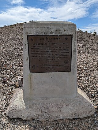
Ragtown was a mining town, now a ghost town, in the Mojave Desert, San Bernardino County, California, United States. John Sutter found gold in the Bagdad-Chase area in about 1898.
Gold Hill in Grass Valley, California, was the site of one of the first discoveries of quartz gold in California. While quartz gold was also found in other areas of Nevada County, California during the same time, it is this find near Wolf Creek that led to quartz-mining frenzy and subsequent creation of the Gold Country quartz-mining industry. The location is honored as a California Historical Landmark.

The following outline is provided as an overview of and topical guide to the U.S. state of California:
William Francis "Grizzly Bill" Holcomb, was an American prospector and the first to discover gold in the region which became known as Holcomb Valley, near present-day Big Bear Lake, California. Holcomb Valley had the most gold of any Southern California field. The boomtown of Belleville grew up there and for a time was the third or fourth largest in Southern California. Holcomb was the first justice of the peace in Belleville and later was elected to county offices.
Belleville, California was a gold mining boomtown in the San Bernardino Mountains of San Bernardino County, California. The settlement grew up rapidly following the discovery of gold by William F. Holcomb in Holcomb Valley early 1860. Which helped the town challenge the seat of San Bernardino County. Belleville was named after Belle, the first child born in the new town. It was a busy mining town for ten years, it was virtually abandoned before the end of the 19th century. It is now a ghost town.

Rancho Temescal was a farming outpost of Mission San Luis Rey de Francia, one of the 21 Franciscan missions established in California by Spain during the late 18th and early 19th centuries. The Mission was located on the coast where Oceanside, California, is today. The Rancho was settled in 1819 by Leandro Serrano, and became the first non-native settlement within the boundaries of what would become Riverside County, California.
William Robert "Bob" Holcomb was an American politician and attorney. Holcomb was the longest serving mayor of San Bernardino, California, to date. He held office as San Bernardino's mayor from 1971 until 1985, and returned to office again from 1989 until 1993. Holcomb has been widely credited with preserving the independence of the San Bernardino Valley Municipal Water District and its local water supply.
George N. Whitman was an American politician. He was elected to the Los Angeles, California, Common Council, the legislative branch of that city's government, in a special election on September 3, 1857, serving until May 10, 1858. As a resident of San Bernardino County, he was a member of the California State Assembly from the 1st District in 1859–60.

Rose La Monte Burcham was an American physician and mining company executive based in Southern California.

The Santa Fe And Salt Lake Trail Monument was designated a California Historic Landmark (No.576) on May 17, 1957. Santa Fe And Salt Lake Trail Monument marks the place two Historic trail merged in Cajon Pass in San Bernardino County, California. The Old Spanish Trail and the Mohave Trail-Mojave Road merged in Cajon Pass. The large white marker is just off the Interstate 15 in Cajon Pass, was U.S. Route 66 in the past. It was built by the Pioneer Society of San Bernardino to remember and honor the pioneers that came west. The marker is 12 feet tall and 7 feet square at the base. Cajon Pass was home to the Serrano Indian, Native Californians that lived in the nearby Atongaibit village, in what is now Hesperia.

The Potash wars were a series of events that took place from 1910 to 1915 in the Searles Valley near Searles Lake, a dry lake, near the current town of Trona in the San Bernardino County of California. The Potash wars gained national and international news at the time due to the involvement of famous lawman Wyatt Earp and the importance of the valley's supply of potash at the time. Potash is an important crop fertilizer and the Searles Valley was a major supplier in the 1910s.


