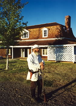
Fort Verde District | |
Location | Bounded by Hance, Coppinger, and Woods Streets, Camp Verde, Arizona |
---|---|
Coordinates | 34°33′55″N111°51′09″W / 34.56528°N 111.85250°W |
Area | 12 acres (4.9 ha) |
Built | 1872 |
Visitation | 10,320 (2022) [1] |
NRHP reference No. | 71000120 |
Added to NRHP | October 7, 1971 [2] |
Fort Verde State Historic Park in the town of Camp Verde, Arizona is a small park that attempts to preserve parts of the Apache Wars-era fort as it appeared in the 1880s. The park was established in 1970 and was added to the National Register of Historic Places a year later.
Fort Verde was established at its current location in 1871. It is significant as "the best preserved and least altered of any military post associated with General Crook’s 1872-73 campaign against the northern Apaches." [3]
Settlers in the mid-19th century near the Verde River grew corn and other crops with the prospect of getting good prices from nearby Prescott, which was the territorial capital, and from nearby miners. The rapid increase in population for the mining economy disrupted the hunting and gathering environments of the local Native American tribes, the Dilzhe'e Apache and Yavapai. In turn, they raided the farmers' crops for food.
The farmers requested military protection from the United States Army and, in 1865, although Arizona was still only a territory, the infantry arrived. They set up several posts over the next few years:
After approximately 1,500 local natives were placed on a reservation by 1872, the army's role changed from protecting the settlers to ensuring that the Indians stayed on the reservation. The last major military engagement with uprising natives took place in 1882 at the Battle of Big Dry Wash.
The fort was never enclosed by walls or stockades, and it never saw fighting on site. At its height, it consisted of twenty-two buildings, only four of which survived until 1956, when local citizens created a small museum in the administration building. They later donated the buildings and ten acres (40,000 m2) as a State Park.
Some of the buildings were built with pice, which is large adobe slabs cast within wooden frames, rather than assembled from the more familiar individual adobe bricks.
The following structures and markers are pictured:
Camp Verde is a town in Yavapai County, Arizona, United States. As of the 2010 census, the population of the town is 10,873.
Fort Concho is a former United States Army installation and National Historic Landmark District located in San Angelo, Texas. It was established in November 1867 at the confluence of the North and South Concho Rivers, on the routes of the Butterfield Overland Mail Route and Goodnight–Loving Trail, and was an active military base for the next 22 years. Fort Concho was the principal base of the 4th Cavalry from 1867 to 1875 and then the "Buffalo Soldiers" of the 10th Cavalry from 1875 to 1882. The troops stationed at Fort Concho participated in Ranald S. Mackenzie's 1872 campaign, the Red River War in 1874, and the Victorio Campaign of 1879–1880.
Fort Larned National Historic Site preserves Fort Larned which operated from 1859 to 1878. It is approximately 5.5 miles (8.9 km) west of Larned, Kansas, United States.
Fort Union National Monument is a unit of the United States National Park Service located 7.7 miles north of Watrous in Mora County, New Mexico.
Fort Kearny was a historic outpost of the United States Army founded in 1848 in the Western United States during the middle and late 19th century. The fort was named after Colonel and later General Stephen Watts Kearny. The outpost was located along the Oregon Trail near Kearney, Nebraska. The town of Kearney took its name from the fort. The "e" was added to Kearny by postmen who consistently misspelled the town name. A portion of the original site is preserved as Fort Kearny State Historical Park by the Nebraska Game and Parks Commission.
Fort Davis National Historic Site is a United States National Historic Site located in the unincorporated community of Fort Davis, Jeff Davis County, Texas. Located within the Davis Mountains of West Texas, the historic site was established in 1961 to protect one of the best remaining examples of a United States Army fort in the southwestern United States.
Fort Reno also known as Fort Connor or Old Fort Reno, was a wooden fort established on August 15, 1865 by the United States Army in Dakota Territory in present-day Johnson County, Wyoming. The fort was built to protect travelers on the Bozeman Trail from Native American tribes.
Fort Bowie was a 19th-century outpost of the United States Army located in southeastern Arizona near the present day town of Willcox, Arizona. The remaining buildings and site are now protected as Fort Bowie National Historic Site.
Fort Buford was a United States Army Post at the confluence of the Missouri and Yellowstone rivers in Dakota Territory, present day North Dakota, and the site of Sitting Bull's surrender in 1881.
Pinedale is an unincorporated community in Navajo County, Arizona, United States. The population was 487 at the 2010 census. The elevation is approximately 6,500 ft (2,000 m) and it is part of the Mogollon Rim mountain range.
Fort Selden was a United States Army post, occupying the area in what is now Radium Springs, New Mexico. The site was long a campground along the El Camino Real de Tierra Adentro. It was the site of a Confederate Army camp in 1861. The U.S. Army established Fort Selden in 1865 for the purpose of protecting westward settlers from Native American raids, but the post fell into disrepair after the American Civil War. It was ultimately abandoned in 1891, due in large part to the decision to expand Fort Bliss and the lack of any expenditures for repair of the facility.
Fort Omaha, originally known as Sherman Barracks and then Omaha Barracks, is an Indian War-era United States Army supply installation. Located at 5730 North 30th Street, with the entrance at North 30th and Fort Streets in modern-day North Omaha, Nebraska, the facility is primarily occupied by the Metropolitan Community College. A Navy Operational Support Center and Marine Corps Reserve unit, along with an Army Reserve unit occupy the periphery of the 82.5 acres (33.4 ha) fort. The government deeded all but four parcels of the land to the Metropolitan Community College in 1974.
The Fort McKavett State Historic Site is a former United States Army installation located in Menard County, Texas. The fort was first established in 1852 as part of a line of forts in Texas intended to protect migrants traveling to California. The fort was deemed unnecessary and abandoned in 1859 and was occupied by settlers. From 1861 to 1863, during the American Civil War, the fort became an outpost of Confederate forces on the Texas frontier until they left for other theaters of the war. When the US Army returned to Texas in the later 1860s, the fort was reoccupied and rebuilt, and became a base for the "Buffalo Soldier", or all-African American, 24th Infantry and 9th Cavalry Regiments.
Fort Lancaster is a former United States Army installation located near Sheffield, Texas. The fort was established in 1855 on the San Antonio–El Paso Road to protect migrants moving toward California through Texas. The US Army occupied Fort Lancaster until Texas seceded from the United States in March 1861 and were replaced at the fort by forces loyal to the Confederate States of America. The Confederate Army held the fort from November 1861 until April 1862, when it was again abandoned and then burned.
Fort Lowell was a United States Army post active from 1873 to 1891 on the outskirts of Tucson, Arizona. Fort Lowell was the successor to Camp Lowell, an earlier Army installation. The Army chose a location just south of the confluence of the Tanque Verde and Pantano creeks, at the point where they form the Rillito River, due to the year-round supply of water during that period. The Hohokam natives had chosen the site centuries earlier, presumably for the same reason. To this day, shards of Hohokam pottery can still be found in the area. The Army claimed a military reservation that encompassed approximately eighty square miles and extended east toward the Rincon Mountains.
Camp Verde was a United States Army facility established on July 8, 1856 in Kerr County, Texas. It was along the road from San Antonio to El Paso.
Fort McDowell is an unincorporated community in Maricopa County, Arizona, United States. Fort McDowell is 23 miles northeast of Phoenix. Fort McDowell has a post office with ZIP code 85264.
Fort Apache Historic Park is a tribal historic park of the White Mountain Apache, located at the former site of Fort Apache on the Fort Apache Indian Reservation. The park interprets the rich and troubled history of relations between the Apache and other Native American tribes at the fort, which was converted into a Bureau of Indian Affairs boarding school after its military use ended. The park, which covers 288 acres (117 ha) of the former fort and school, as well as a nearby military cemetery, form the National Historic Landmark Fort Apache and Theodore Roosevelt School historic district.