Leslie Canyon National Wildlife Refuge

Last updated
Leslie Canyon National Wildlife Refuge
IUCN category IV (habitat/species management area)
Leslie Canyon NWR.jpg
Usa edcp relief location map.png
Red pog.svg
Map of the United States
Location Cochise County, Arizona, United States
Nearest city Douglas, Arizona
Coordinates 31°35′19″N109°30′42″W / 31.5885°N 109.51174°W / 31.5885; -109.51174 Coordinates: 31°35′19″N109°30′42″W / 31.5885°N 109.51174°W / 31.5885; -109.51174
Area2,770 acres (11.2 km2)
Established1988
Governing body U.S. Fish and Wildlife Service
Website Leslie Canyon National Wildlife Refuge

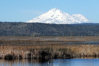
Leslie Canyon National Wildlife Refuge is a National Wildlife Refuge of the United States located in Arizona. The 2,770-acre (11.2 km2) refuge was established in 1988 to protect habitat for the endangered Yaqui Chub (Gila purpurea) and Yaqui Topminnow (Poeciliopsis occidentalis sonorensis). The refuge also protects a rare velvet ash-cottonwood-black walnut gallery forest.

National Wildlife Refuge type of federal conservation area in the United States

National Wildlife RefugeSystem is a designation for certain protected areas of the United States managed by the United States Fish and Wildlife Service. The National Wildlife Refuge System is the system of public lands and waters set aside to conserve America's fish, wildlife, and plants. Since President Theodore Roosevelt designated Florida's Pelican Island National Wildlife Refuge as the first wildlife refuge in 1903, the system has grown to over 562 national wildlife refuges and 38 wetland management districts encompassing more than 150,000,000 acres (607,028 km2).

Arizona state of the United States of America

Arizona is a state in the southwestern region of the United States. It is also part of the Western and the Mountain states. It is the sixth largest and the 14th most populous of the 50 states. Its capital and largest city is Phoenix. Arizona shares the Four Corners region with Utah, Colorado, and New Mexico; its other neighboring states are Nevada and California to the west and the Mexican states of Sonora and Baja California to the south and southwest.

Poeciliopsis occidentalis sonorensis species of fish

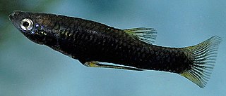
The Yaqui topminnow is a species of fish in the family Poeciliidae. Its scientific name is Poeciliopsis sonoriensis; it is also sometimes considered a subspecies of Poeciliopsis occidentalis as P. o. sonoriensis.

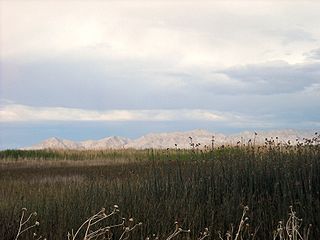
This area is part of the basin and range geologic region, characterized by linear mountain ranges which are separated by broad, flat basins. The region was impacted by relatively recent volcanic activity, leaving volcanic plugs and cinder cones visible throughout the San Bernardino Valley. Earthquakes have further altered the region and helped allow the flow of many springs and seeps. All of these dynamic geological events have played major roles in shaping the valley, catching and storing crucial water, helping determine the variety of plants and animals present.

Depression (geology) landform sunken or depressed below the surrounding area

A depression in geology is a landform sunken or depressed below the surrounding area. Depressions form by various mechanisms.

San Bernardino Valley (Arizona)

The San Bernardino Valley of Arizona is a 35-mi long (56 km) northeast-by-southwest trending valley in extreme southeast Cochise County, Arizona. The north end of the valley merges into the northwest-by-southeast trending San Simon Valley; both merge in western perimeter Hidaldgo County, New Mexico. The valley is an asymmetric graben.

Earthquake Shaking of the surface of the earth caused by a sudden release of energy in the crust

An earthquake is the shaking of the surface of the Earth, resulting from the sudden release of energy in the Earth's lithosphere that creates seismic waves. Earthquakes can range in size from those that are so weak that they cannot be felt to those violent enough to toss people around and destroy whole cities. The seismicity, or seismic activity, of an area is the frequency, type and size of earthquakes experienced over a period of time. The word tremor is also used for non-earthquake seismic rumbling.

The San Bernardino Valley once supported permanently flowing creeks, springs, and marshy wetlands. In addition, the giant sacaton grassland in the valley was once described as "a luxuriant meadow some eight or ten miles long and a mile wide." The dependable source of water and grass made the area not only invaluable to a huge diversity of fish and wildlife, but also a center of human activity for centuries.

Meadow field vegetated primarily by grass and other non-woody plants (grassland)

A meadow is a open habitat, or field, vegetated by grass and other non-woody plants. They attract a multitude of wildlife and support flora and fauna that could not thrive in other conditions. They provide areas for courtship displays, nesting, food gathering, pollinating insects, and sometimes sheltering, if the vegetation is high enough, making them ecologically important. There are multiple types of meadows, such as agricultural, transitional, and perpetual, each important to the ecosystem. Meadows may be naturally occurring or artificially created from cleared shrub or woodland.

With expanding settlement beginning in the late 19th century came farming, mining, and livestock production, all of which competed for the same precious water. While the extensive wetlands here once provided historic habitat for eight different kinds of native fish, the lowering water table led to severe changes in the habitat and the eventual local extinctions of many species.

Mining The extraction of valuable minerals or other geological materials from the earth

Mining is the extraction of valuable minerals or other geological materials from the earth, usually from an ore body, lode, vein, seam, reef or placer deposit. These deposits form a mineralized package that is of economic interest to the miner.

Livestock Domesticated animals

Livestock is commonly defined as domesticated animals raised in an agricultural setting to produce labor and commodities such as meat, eggs, milk, fur, leather, and wool. The term is sometimes used to refer solely to those that are bred for consumption, while other times it refers only to farmed ruminants, such as cattle and goats. Horses are considered livestock in the United States. The USDA uses livestock similarly to some uses of the term “red meat”, in which it specifically refers to all the mammal animals kept in this setting to be used as commodities. The USDA mentions pork, veal, beef, and lamb are all classified as livestock and all livestock is considered to be red meats. Poultry and fish are not included in the category.

Extinction Termination of a taxon by the death of the last member

In biology, extinction is the termination of an organism or of a group of organisms (taxon), usually a species. The moment of extinction is generally considered to be the death of the last individual of the species, although the capacity to breed and recover may have been lost before this point. Because a species' potential range may be very large, determining this moment is difficult, and is usually done retrospectively. This difficulty leads to phenomena such as Lazarus taxa, where a species presumed extinct abruptly "reappears" after a period of apparent absence.

Related Research Articles

Colorado Desert desert in California, United States

California's Colorado Desert is a part of the larger Sonoran Desert. It encompasses approximately 7 million acres (28,000 km2), including the heavily irrigated Coachella and Imperial valleys. It is home to many unique flora and fauna.

Lower Klamath National Wildlife Refuge wildlife refuge in Oregon and California, USA

The Lower Klamath National Wildlife Refuge is a National Wildlife Refuge of the United States on the border between California and Oregon. It is operated by the United States Fish and Wildlife Service. The refuge was designated a National Historic Landmark on October 16, 1965.

Ankeny National Wildlife Refuge

Ankeny National Wildlife Refuge is located in the fertile Willamette Valley of northwestern Oregon, 12 miles (19 km) south of Salem. The valley was once a rich mix of wildlife habitats. Valley wetlands were once extensive, with meandering stream channels and vast seasonal marshes. Today, the valley is a mix of farmland and growing cities, with few areas remaining for wildlife.

Baskett Slough National Wildlife Refuge protected area

Baskett Slough National Wildlife Refuge is located in northwestern Oregon, 10 miles (16 km) west of Salem in Polk County. Situated in open farmland near the eastern foothills of the Oregon Coast Range with the broad Willamette Valley and the Cascade Range to the east, elevations range from 185 to 414 feet MSL. The Willamette Valley, with its mild, rainy winter climate, is an ideal environment for wintering waterfowl. The valley was once a rich mix of wildlife habitats with extensive wetlands, meandering stream channels and vast seasonal marshes. Today, the valley is a mix of farmland and growing cities, with few areas remaining for wildlife. The Refuge consists of 1,173 acres (4.75 km²) of cropland, which provide forage for wintering geese, 300 acres (1.2 km²) of forests, 550 acres (2.2 km²) of grasslands, and 500 acres (2.0 km²) of shallow water seasonal wetlands and 35 acres (0.14 km²) of permanent open water. In 1965, Baskett Slough National Wildlife Refuge was created to help ensure some of the original habitat remained for species preservation. The refuge is managed by the U.S. Fish and Wildlife Service, an agency of the U.S. Department of the Interior.

Beautiful shiner species of fish

The beautiful shiner is a species of ray-finned fish in the family Cyprinidae. It is found in Mexico and Arizona and New Mexico in the United States. It is one of 22 species of Cyprinella found in North America.

Yaqui chub species of fish

The Yaqui chub is a species of freshwater fish in the family Cyprinidae. It is found in northern Mexico and the United States. The Yaqui chub is a medium-sized minnow fish that historically occurred in streams of Rios Matape, Sonora, and the Yaqui systems of Sonora, Mexico. It is one of the five species of the genus Gila in Arizona. The Yaqui chub is closely related to G. ditaenia, and G. orcutti ; and shares several physical characteristics with the G. orcutti, but proves different by having a black wedge near the base of the caudal fin.

Ictalurus pricei, the Yaqui catfish, is a species of North American freshwater catfish native to Mexico and Arizona.

Turnbull National Wildlife Refuge

The Turnbull National Wildlife Refuge is located six miles (10 km) south of Cheney, Washington, on the eastern edge of the Columbia Basin in Spokane County in northeastern Washington. Turnbull NWR encompasses more than 18,000 acres (7,300 ha) of the Channeled Scablands. The ecosystem that predominates the refuge is unique within the National Wildlife Refuge System and has characteristics that distinguish it from natural reserves worldwide. The combination of basalt outcrops, channeled canyons, and ponderosa pine forests infused in a diverse landscape of over 130 marshes, wetlands, and lakes creates an environment of aesthetic beauty as well as high quality wildlife habitat. The refuge is named for Cyrus Turnbull who lived on the site in the 1880s.

Northern Basin and Range ecoregion

The Northern Basin and Range ecoregion is a Level III ecoregion designated by the United States Environmental Protection Agency (EPA) in the U.S. states of Oregon, Idaho, Nevada, Utah, and California. It contains dissected lava plains, rolling hills, alluvial fans, valleys, and scattered mountain ranges in the northern part of the Great Basin. Although arid, the ecoregion is higher and cooler than the Snake River Plain to the north and has more available moisture and a cooler climate than the Central Basin and Range to the south. Its southern boundary is determined by the highest shoreline of Pleistocene Lake Bonneville, which once inundated the Central Basin and Range. The western part of the region is internally drained; its eastern stream network drains to the Snake River system.

Sheldon National Wildlife Refuge

The Sheldon National Wildlife Refuge is a 573,504-acre (232,089 ha) national wildlife refuge on the northern border of the U.S. state of Nevada. A very small part extends northward into Oregon. It is managed by the United States Fish and Wildlife Service (USFWS) as the Nevada component of the Sheldon-Hart Mountain National Wildlife Refuge Complex, which is headquartered in Lakeview, Oregon. The Sheldon Refuge is noted for its population of wild horses, now all removed and The Virgin Valley Mining District for Black Precious Opals,the State Gemstone, still very active with multiple fee dig mines. A point within the refuge is also the farthest place in the continuous US from a McDonald's restaurant, at just 115 miles.

Fish Springs National Wildlife Refuge wildlife refuge in Juab County, Utah, United States

Fish Springs National Wildlife Refuge is at the southern end of the Great Salt Lake Desert, part of the Great Basin in Juab County, Utah. The Refuge is managed by the United States Fish and Wildlife Service. As an oasis in the Great Basin Desert in western Utah, Fish Springs serves a variety of species including fish, migratory birds, deer, coyotes, pronghorn, cougars and other native species. The reserve can be reached by paved road from Lynndyl, Utah to Topaz Mountain and then by improved dirt road to the Pony Express Road/Lincoln Highway improved dirt road which runs through the Refuge. The Refuge also is a recreational area for permitted outdoor activities. The Fish Springs Range runs north to south and is immediately west of the Wildlife Refuge.

San Bernardino National Wildlife Refuge

The San Bernardino National Wildlife Refuge is located on the U.S.-Mexican border in Cochise County, Arizona. Situated at 3,720 to 3,920 feet (1,190 m) elevation in the bottom of a wide valley, the refuge encompasses a portion of the headwaters of the Yaqui River, which drains primarily western Chihuahua and eastern Sonora, Mexico. The 2,309-acre (9.34 km2) ranch was acquired by the U.S. Fish and Wildlife Service in 1982 to protect the water resources and provide habitat for endangered native fishes.

Bitter Creek National Wildlife Refuge

The Bitter Creek National Wildlife Refuge is located in the foothills of the southwestern San Joaquin Valley in Kern County, California. The refuge is one of four units of the Hopper Mountain National Wildlife Refuge Complex for California condors.

The Yaqui longfin dace is a small fish of the American Southwest and northern Mexico, and considered a form of the longfin dace. It is often referred to as Agosia chrysogaster sp 1.

Columbia National Wildlife Refuge

Columbia National Wildlife Refuge is a scenic mixture of rugged cliffs, canyons, lakes, and sagebrush grasslands. Formed by fire, ice, floods, and volcanic tempest, carved by periods of extreme violence of natural forces, the refuge lies in the middle of the Drumheller Channeled Scablands of central Washington. The area reveals a rich geologic history highlighted by periods of dramatic activity, each playing a major role in shaping the land. The northern half of the refuge, south of Potholes Reservoir, is a rugged jumble of cliffs, canyons, lakes, and remnants of lava flows. This part of the Scablands, known as the Drumheller Channels, is the most spectacularly eroded area of its size in the world and was designated as a National Natural Landmark in 1986.

Cold Springs National Wildlife Refuge

Cold Springs National Wildlife Refuge is a 3,117-acre (12.61 km2) National Wildlife Refuge located 7 miles (10 km) northeast of Hermiston and 3 miles (5 km) south of the Columbia River in Umatilla County, Oregon; The refuge was established in 1909 as a preserve and breeding ground for native birds. It consists of diverse wetland habitats surrounded by upland habitat of big sagebrush and native steppe grasses. A riparian component of willow and cottonwood provides refuge for birds, mammals, and other animals.

Kern National Wildlife Refuge

Kern National Wildlife Refuge is a 1,249-acre (5.05 km2) protected area located in the southern portion of California's San Joaquin Valley, 20 miles west of the city of Delano. Situated on the southern margin of what was once the largest freshwater wetland complex in the western United States, Kern National Wildlife Refuge provides optimum wintering habitat for migratory birds with an emphasis on waterfowl and water birds.

Summer Lake Wildlife Area

The Summer Lake Wildlife Area is a 29.6-square-mile (77 km2) wildlife refuge located on the northwestern edge of the Great Basin drainage in south-central Oregon. It is administered by the Oregon Department of Fish and Wildlife. The refuge is an important stop for waterfowl traveling along the Pacific Flyway during their spring and fall migrations. The Summer Lake Wildlife Area also provides habitat for shorebirds and other bird species as well as wide variety of mammals and several fish species. The Ana River supplies the water for the refuge wetlands.

Ash Creek (California)

Ash Creek is a 35-mile (56 km) long stream located to the east of the Cascade Range in northeastern California, flowing through Lassen County and Modoc County. It drains a semi-arid watershed composed mainly of volcanic hills and agricultural valleys.

References

PD-icon.svg This article incorporates  public domain material from websites or documents ofthe United States Fish and Wildlife Service .

United States Fish and Wildlife Service US Federal Government agency

The United States Fish and Wildlife Service is an agency of the US Federal Government within the US Department of the Interior dedicated to the management of fish, wildlife, and natural habitats. The mission of the agency is "working with others to conserve, protect, and enhance fish, wildlife, plants and their habitats for the continuing benefit of the American people."