Powers Butte Wildlife Area

Last updated
Powers Butte Wildlife Area
IUCN category IV (habitat/species management area)
USA Arizona location map.svg
Red pog.svg
Location Maricopa County, Arizona, United States
Nearest city Buckeye, AZ
Coordinates 33°18′24″N112°44′05″W / 33.3067°N 112.7348°W / 33.3067; -112.7348 Coordinates: 33°18′24″N112°44′05″W / 33.3067°N 112.7348°W / 33.3067; -112.7348 [1]
Area1,120 acres (450 ha)
Established1982
Governing body Arizona Game and Fish Department
www.azgfd.gov/outdoor_recreation/wildlife_area_powers_butte.shtml

The Powers Butte Wildlife Area is located along the east side of the Gila River, about twenty miles north of Gila Bend, in Maricopa County, Arizona. It was founded in 1982 and spans 1,120 acres. [2]

Gila River river in the United States of America

The Gila River is a 649-mile (1,044 km)-long tributary of the Colorado River flowing through New Mexico and Arizona in the United States. The river drains an arid watershed of nearly 60,000 square miles (160,000 km2) that lies mainly within the U.S., but also extends into northern Sonora, Mexico. Indigenous peoples have lived along the river for at least 2,000 years, establishing complex agricultural societies before European exploration of the region began in the 16th century. However, European Americans did not permanently settle the Gila River watershed until the mid-19th century.

Gila Bend, Arizona Town in Arizona, United States

Gila Bend, founded in 1872, is a town in Maricopa County, Arizona, United States. The town is named for an approximately 90-degree bend in the Gila River, which is near the community's current location. According to the 2010 census, the population of the town is 1,922.

Maricopa County, Arizona County in Arizona

Maricopa County is located in the south-central part of the U.S. state of Arizona. The U.S. Census Bureau estimated its population was 4,410,824 as of 2018, making it the state's most populous county, and the fourth-most populous in the United States, containing more than half the population of Arizona. It is more populous than 23 states. The county seat is Phoenix, the state capital and fifth-most populous city in the United States.

Contents

Area description

Powers Butte Wildlife Area lies at less than 1,000 feet in elevation within the central Gila River valley south of Phoenix, Arizona. The 91st Avenue Wastewater Treatment Plant, local agriculture, intermittent tributary flows, and groundwater all feed the Gila River through the wildlife area, creating dense stands of salt cedar, and marsh and wetland habitats. Powers Butte, a steep knoll formed by volcanic boulder, provides an overlook to the surrounding valley and river. [2]

Phoenix, Arizona State capital city of Arizona, United States

Phoenix is the capital and most populous city in Arizona, with 1,660,272 people. It is also the fifth most populous city in the United States, and the only state capital with a population of more than one million residents.

Winters are mild, high temperatures falling below 60 °F are not common. On relatively rare occasions, temperatures can drop below freezing during the coolest parts of the year. Summer afternoons can exceed 100 °F from late May through late September. Rainfall is spotty and sporadic, and in most years totals less than eight inches. Dust storms can occur occasionally. [2]

Restrictions

Flora and fauna

Plantlife

Habitats present in this wildlife area include river and marshland, creosote desert, current agriculture, quail-brush/mesquite, mesquite, and tamarisk. [2]

Vegetation consists of:

Willow genus of plants

Willows, also called sallows and osiers, form the genus Salix, around 400 species of deciduous trees and shrubs, found primarily on moist soils in cold and temperate regions of the Northern Hemisphere. Most species are known as willow, but some narrow-leaved shrub species are called osier, and some broader-leaved species are referred to as sallow. Some willows are low-growing or creeping shrubs; for example, the dwarf willow rarely exceeds 6 cm (2.4 in) in height, though it spreads widely across the ground.

<i>Populus sect. Aigeiros</i> section of plants

Populus section Aigeiros is a section of three species in the genus Populus, the poplars. Like some other species in the genus Populus, they are commonly known as cottonwoods. The species are native to North America, Europe, and western Asia. In the past, as many as six species were recognized, but recent trends have been to accept just three species, treating the others as subspecies of P. deltoides.

Creosote chemical compound

Creosote is a category of carbonaceous chemicals formed by the distillation of various tars and pyrolysis of plant-derived material, such as wood or fossil fuel. They are typically used as preservatives or antiseptics.

Many types of wildlife in the Southwest are dependent on riparian habitats for their survival. Riparian habitats are the most noticeable plant life on the Powers Butte Wildlife Area. The most common plants are cottonwood, salt cedar and mesquite. Salt cedar was introduced to Arizona many years ago and does not naturally occur here. Most of the original cottonwood and willow trees have been replaced with salt cedar. The upper flood plain, which once was a mesquite forest, also contains a lot of salt cedar. [2]

In this wildlife area, riparian areas offer home to more sensitive and rare species than other habitats do. This area is highly valued for its protection of sensitive species and habitats in Arizona. With appropriate enhancement, the amount and quality of riparian and wetland habitats can be increased, and diversified to support more species that depend on such areas. [2]

Wildlife

Mourning doves, white-winged doves, Gambel's quail, and cottontail rabbits inhabit the Powers Butte Wildlife Area. Other wildlife found here include Sonoran collared lizard, coyote, diamondback rattlesnake, Gila monsters, desert tortoise, greater roadrunner, and great blue heron. Particularly abundant during migration and in the winter, various birds, including a wide assortment of hawks and other birds of prey, find food and shelter within the bounds of this wildlife area as well. [2]

Management history and goals

Roosevelt Dam was built on the upper Salt River in the early 1900s. This dam decreased the amount of water entering the Gila River where the two rivers meet. During this same time, the amount of water in the Gila River was decreased. The loss of water in the rivers resulted in the loss of most of the healthy cottonwood and willow trees along this portion of the Gila River. These trees require a lot of water to stay healthy. A long drought during the 1940s and early 1950s, and increases in the amount of water being used, accelerated the loss of riparian habitats. [2]

Riparian and mesquite forests were also cleared to grow crops. These agriculture uses continue in many locations today. During the mid-1900s, many of the crops grown were small grains that provide an important food source for mourning and white-winged doves. Because of the large amount of food, large numbers of doves concentrated in the area. The salt cedar, which has replaced most of the native riparian trees in the area, provides good nesting places for doves. [2]

Because of abundant food and nesting places, this area became known as "Arizona's dove factory" during the 1950s and 1960s. Most agriculture has moved away from small grains today, and the number of doves has decreased with the available food supply. [2]

Powers Butte was acquired from the Bureau of Reclamation in 1982 to make up for wildlife habitat losses along the lower Colorado River. Management objectives include making up for those losses by providing quality wildlife habitat and recreational opportunities along the Gila River. Powers Butte Wildlife Area is managed for the enhancement of its riparian and aquatic habitats. [2]

See also

Related Research Articles

<i>Tamarix</i> Genus of plants

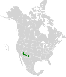
The genus Tamarix is composed of about 50–60 species of flowering plants in the family Tamaricaceae, native to drier areas of Eurasia and Africa. The generic name originated in Latin and may refer to the Tamaris River in Hispania Tarraconensis (Spain).

Virgin River river in Utah, Arizona, and Nevada in the United States

The Virgin River is a tributary of the Colorado River in the U.S. states of Utah, Nevada, and Arizona. The river is about 162 miles (261 km) long. It was designated Utah's first wild and scenic river in 2009, during the centennial celebration of Zion National Park.

Colorado Desert desert in California, United States

California's Colorado Desert is a part of the larger Sonoran Desert. It encompasses approximately 7 million acres (28,000 km2), including the heavily irrigated Coachella and Imperial valleys. It is home to many unique flora and fauna.

Riparian zone interface between land and a river or stream

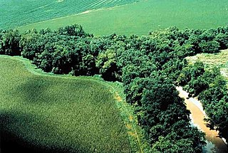
A riparian zone or riparian area is the interface between land and a river or stream. Riparian is also the proper nomenclature for one of the terrestrial biomes of the Earth. Plant habitats and communities along the river margins and banks are called riparian vegetation, characterized by hydrophilic plants. Riparian zones are important in ecology, environmental resource management, and civil engineering because of their role in soil conservation, their habitat biodiversity, and the influence they have on fauna and aquatic ecosystems, including grasslands, woodlands, wetlands, or even non-vegetative areas. In some regions the terms riparian woodland, riparian forest, riparian buffer zone,riparian corridor and riparian strip are used to characterize a riparian zone. The word riparian is derived from Latin ripa, meaning river bank.

Scaled quail species of bird in the New World quail family

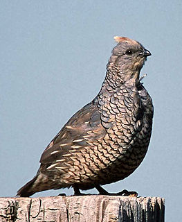
The scaled quail, also commonly called blue quail or cottontop, is a species of the New World quail family. It is a bluish gray bird found in the arid regions of the Southwestern United States to Central Mexico. This species is an early offshoot of the genus Callipepla, diverging in the Pliocene.

White-throated woodrat species of mammal

The white-throated woodrat is a species of rodent in the family Cricetidae. It is found from central Mexico north to Utah and Colorado in the United States. It is primarily a western species in the United States, extending from central Texas west to southeastern California. Populations east of the Rio Grande in New Mexico and Trans-Pecos Texas, previously considered to be variants of the white-throated woodrat, have since 1988 been assigned to the white-toothed woodrat.

Bill Williams River river in the United States of America

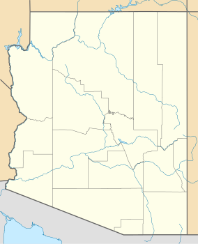
The Bill Williams River is a 46.3-mile-long (74.5 km) river in west-central Arizona where it, along with its tributary, the Santa Maria River, form the boundary between Mohave County to the north and La Paz County to the south. It is a major drainage westwards into the Colorado River of the Lower Colorado River Valley south of Hoover Dam and Lake Mead, and the drainage basin covers portions of northwest, and west-central Arizona. The equivalent drainage system paralleling the east–west lower reaches of the Bill Williams is the Gila River, which flows east-to-west across central Arizona, joining the Colorado River in the southwest at Yuma. The confluence of the Bill Williams River with the Colorado is north of Parker, and south of Lake Havasu City.

Havasu Wilderness

Havasu Wilderness is a 17,801-acre (72 km2) wilderness area located within the Havasu National Wildlife Refuge near Lake Havasu in the U.S. states of Arizona and California. 14,606 acres (59 km2) are located in Arizona and 3,195 acres (13 km2) are located in California.

Hassayampa River river in the United States of America

The Hassayampa River is an intermittent river, the headwaters of which are just south of Prescott, Arizona, and flows mostly south towards Wickenburg, entering the Gila River near Hassayampa. Although the river has only subsurface flow for much of the year, it has significant perennial flows above ground within the Hassayampa River Canyon Wilderness and the Nature Conservancy's Hassayampa River Preserve, near Wickenburg. The river is about 113 miles (182 km) long, with a watershed of 1,410 square miles (3,700 km2), most of it desert.

<i>Atriplex lentiformis</i> species of plant

Atriplex lentiformis is a species of saltbush.

<i>Northern tamarisk beetle</i> species of beetle

Diorhabda carinulata is a species of leaf beetle known as the northern tamarisk beetle, which feeds on tamarisk trees from southern Russia and Iran to Mongolia and western China. This beetle is used in North America as a biological pest control agent against saltcedar or tamarisk, an invasive species in arid and semiarid ecosystems.

<i>Diorhabda elongata</i> species of beetle

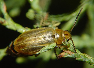
Diorhabda elongata is a species of leaf beetle known as the Mediterranean tamarisk beetle (MTB) which feeds on tamarisk trees from Portugal and Algeria east to southern Russia. The MTB is used in North America as a biological pest control agent against saltcedar or tamarisk, an invasive species in arid and semi-arid ecosystems.

<i>Diorhabda sublineata</i> species of beetle

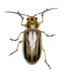
Diorhabda sublineata is a species of leaf beetle known as the subtropical tamarisk beetle (STB) which feeds on tamarisk trees from Portugal, Spain and France to Morocco, Senegal, Algeria, Tunisia, Egypt, Yemen, and Iraq. It is used in North America as a biological pest control agent against saltcedar or tamarisk, an invasive species in arid and semi-arid ecosystems.

Cottonwood Canyon Wilderness

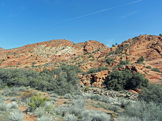
Cottonwood Canyon Wilderness is a 11,712-acre (47.4 km2) wilderness area in the US state of Utah. It was designated March 30, 2009, as part of the Omnibus Public Land Management Act of 2009. Located adjacent to the southern edge of the Dixie National Forest, it encompasses and protects a transition zone between the Colorado Plateau to the east and the Mojave Desert to the west. It is bordered by the Cottonwood Forest Wilderness to the northeast and is itself a part of the Red Cliffs National Conservation Area.

Imperial National Wildlife Refuge

The Imperial National Wildlife Refuge protects wildlife habitat along 30 miles (50 km) of the lower Colorado River in Arizona and California, including the last un-channeled section before the river enters Mexico. The Imperial Refuge Wilderness, a federally designated, 15,056-acre (60.93 km2), wilderness area is protected within the refuge. It also surrounds the Picacho State Recreation Area. This section of the Colorado River is popular for boating, hiking, fishing, camping, exploring old mining camps and wildlife watching.

Canebrake Ecological Reserve

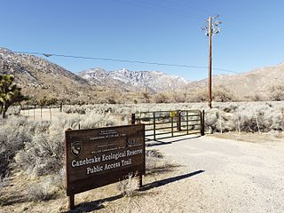
Canebrake Ecological Reserve is a 6,700-acre (27 km2) nature reserve in the South Fork Valley of Kern County, 20 miles (32 km) east of Lake Isabella, California. It is located in the Southern Sierra Nevada region.

Arizona Mountains forests

The Arizona Mountains forests are a temperate coniferous forests ecoregion of the southwest United States with a rich variety of woodland habitats and wildlife.

Desert riparian

Desert riparian is a North American desert vegetation type occurring in the bottoms of canyons and drainages that have water at or near the surface most of the year. It is contrasted with the desert dry wash vegetation type in which water at or near the surface is lacking most of the year. The visual character is of large, lush green trees surrounded by dry desert vegetation and soil coloration. The area may be in a patch surrounding a spring (oasis), or in a strand following the course of water flow. Over 80% of known desert wildlife species use desert riparian areas. Common dominant species include Fremont cottonwood, Arizona ash, arroyo willow, Goodding's willow, red willow, California fan palm, and invasive species such as salt cedar, giant reed, and Russian olive. Salt cedar is particularly causing problems for this ecosystem because it is able to extract water more efficiently than cottonwoods and willows. Many noninvasive non-native species may also be found because springs and surface water areas in the desert often were old homesites where such species were intentionally planted, such as elm, black locust, and assorted fruit trees.

Flora of the Colorado Desert

Flora of the Colorado Desert, located in Southern California. The Colorado Desert is a sub-region in the Sonoran Desert ecoregion of southwestern North America. It is also known as the Low Desert, in contrast to the higher elevation Mojave Desert or High Desert, to its north.

Hassayampa River Preserve

The Hassayampa River Preserve is a 770 acre riparian nature reserve owned by The Nature Conservancy in the US state of Arizona, near Wickenburg in Maricopa County. The Hassayampa River has mostly subterranean flows for most of its 113 miles (182 km) length, the stretch contained within the Preserve has year-round flowing water.

References

  1. "Powers Butte". Geographic Names Information System . United States Geological Survey . Retrieved December 14, 2013.
  2. 1 2 3 4 5 6 7 8 9 10 11 "Powers Butte Wildlife Area". Arizona Game and Fish Department. Archived from the original on 2012-11-14. Retrieved 2012-12-11.