Muir Woods National Monument

Last updated

Muir Woods National Monument
Muir Woods Path Through Trees June 2022.jpg
Redwood trees at the Muir Woods National Monument
Relief map of California.png
Red pog.svg
Usa edcp relief location map.png
Red pog.svg
Location Marin County, California, U.S.
Nearest city Mill Valley, CA
Coordinates 37°53′31″N122°34′15″W / 37.89194°N 122.57083°W / 37.89194; -122.57083
Area554 acres (224 ha) [1]
CreatedJanuary 9, 1908 (1908-January-09)
Visitors798,625(in 2022) [2]
Governing body National Park Service
Website Muir Woods National Monument
DesignatedJanuary 9, 2008
Reference no.07001396 [3]

Muir Woods National Monument is a United States National Monument managed by the National Park Service and named after naturalist John Muir. It is located on Mount Tamalpais near the Pacific coast in southwestern Marin County, California. The Monument is part of the Golden Gate National Recreation Area, and is 12 miles (19 km) north of San Francisco. It protects 554 acres (224 ha), [4] of which 240 acres (97 ha) are old growth coast redwood (Sequoia sempervirens) forests, [5] one of a few such stands remaining in the San Francisco Bay Area.

Contents

Geography

Entrance To Muir Woods National Monument Muir Woods National Monument, Marin County, California.jpg
Entrance To Muir Woods National Monument

Ecosystem

The Muir Woods National Monument is an old-growth coastal redwood forest. [6] Due to its proximity to the Pacific Ocean, the forest is regularly shrouded in a coastal marine layer fog, contributing to a wet environment that encourages vigorous plant growth. The fog is also vital for the growth of the redwoods as they use moisture from the fog during drought seasons, particularly during dry summers. [7]

Muir Woods National Monument
Climate chart (explanation)
J
F
M
A
M
J
J
A
S
O
N
D
 
 
64
 
 
12
7
 
 
74
 
 
16
10
 
 
86
 
 
20
9
 
 
45
 
 
20
9
 
 
1
 
 
17
10
 
 
4
 
 
20
12
 
 
1
 
 
23
14
 
 
2
 
 
22
14
 
 
10
 
 
27
13
 
 
25
 
 
23
12
 
 
111
 
 
14
8
 
 
177
 
 
9
6
Average max. and min. temperatures in °C
Precipitation totals in mm
Source: [8]
Imperial conversion
JFMAMJJASOND
 
 
2.5
 
 
54
45
 
 
2.9
 
 
61
50
 
 
3.4
 
 
68
48
 
 
1.8
 
 
68
48
 
 
0
 
 
63
50
 
 
0.2
 
 
68
54
 
 
0
 
 
73
57
 
 
0.1
 
 
72
57
 
 
0.4
 
 
81
55
 
 
1
 
 
73
54
 
 
4.4
 
 
57
46
 
 
7
 
 
48
43
Average max. and min. temperatures in °F
Precipitation totals in inches

Climate

The monument remains cool and moist year round with daytime temperatures averaging between 40 and 70 degrees Fahrenheit (4 to 21 °C). Rainfall is heavy during the winter and summers are almost completely dry with the exception of fog drip caused by the fog passing through the trees. Annual precipitation in the park ranges from 39.4 inches (1,000 mm) in the lower valley to 47.2 inches (1,200 mm) higher up in the mountain slopes.

Soils and bedrock

The redwoods grow on brown humus-rich loam which may be gravelly, stony or somewhat sandy. This soil has been assigned to the Centissima series, which is always found on sloping ground. It is well drained, moderately deep, and slightly to moderately acidic. [9] It has developed from a mélange in the Franciscan Formation. [10] More open areas of the park have shallow gravelly loam of the Barnabe series, or deep hard loam of the Cronkhite series. [11]

History

One hundred fifty million years ago ancestors of redwood and sequoia trees grew throughout the United States. Today, the Sequoia sempervirens can be found only in a narrow, cool coastal belt from Monterey County, California, in the south to Oregon in the north.

Before the logging industry came to California, there were an estimated 2 million acres (8,000 km2) of old growth forest containing redwoods growing in a narrow strip along the coast.

By the early 20th century, most of these forests had been cut down. Just north of the San Francisco Bay, one valley named Redwood Canyon remained uncut, mainly due to its relative inaccessibility.

This was noticed by William Kent, a rising California politician who would soon be elected to the U.S. Congress. He and his wife, Elizabeth Thacher Kent, purchased 611 acres (247 ha) of land from the Tamalpais Land and Water Company for $45,000 with the goal of protecting the redwoods and the mountain above them. The deal was facilitated by banker Lovell White and his activist wife, Laura Lyon White. [12]

In 1907, a water company in nearby Sausalito planned to dam Redwood Creek, thereby flooding the valley. When Kent objected to the plan, the water company threatened to use eminent domain and took him to court to attempt to force the project to move ahead. Kent sidestepped the water company's plot by donating 295 acres (119 ha) of the redwood forest to the federal government, thus bypassing the local courts.

John Muir (lower left) teaching a group at Muir Woods in the early 1900s John Muir Teaching GOGA 32470-0347.jpg
John Muir (lower left) teaching a group at Muir Woods in the early 1900s

Muir Woods became a national monument in 1908 before the National Park Service existed when it was signed into law under the Antiquities Act by president Theodore Roosevelt. Prior to this, Muir Woods was called "Redwoods Canyon" before it was bought by the Kent family. The family bought the area to protect and preserve it and worked to get President Roosevelt to declare it a monument. In legislation written to protect Muir Woods, it was described as, "of extraordinary scientific interest and importance because of the primeval character of the forest in which it is located, and of the character, age and size of the trees". Once declared a national monument, Muir Woods was immediately protected and placed under the care of the United States Government. The Antiquities Act was the first of its kind to provide protection for natural resources.

The original suggested name of the monument was the Kent Monument but Kent insisted the monument be named after naturalist John Muir, whose environmental campaigns helped to establish the National Park system, and President Roosevelt agreed with this proposition.

A wood statue of John Muir at the Muir Woods National Monument John Muir Wood Carving.jpg
A wood statue of John Muir at the Muir Woods National Monument

Kent and Muir had become friends over shared views of wilderness preservation, but Kent's later support for the flooding of Hetch Hetchy caused Muir to end their friendship. [13]

In December 1928, the Kent Memorial was erected at the Kent Tree in Fern Canyon. This tree—a Douglas fir, not a redwood—was said to be Kent's favorite. Due to its height of 280 feet (85 m) and location on a slope, the tree leaned towards the valley for more than 100 years. Storms in El Niño years of 1981 and 1982 caused the tree to tilt even more and took out the top 40 feet (12 m) of the tree. [14] During the winter of 2002–03, many storms brought high winds to Muir Woods causing the tree to lean so much that a fissure developed in January 2003. This fissure grew larger as the tree slowly leaned more and more, forcing the closure of some trails. On March 18, 2003, at around 8:28 pm, the tree fell, damaging several other trees nearby. [14] The closed trails have since been reconfigured and reopened.

In 1937, the Golden Gate Bridge was completed and park attendance tripled, reaching over 180,000. Muir Woods is one of the major tourist attractions of the San Francisco Bay Area, with 776,000 visitors in 2005.

President Franklin Delano Roosevelt died on April 12, 1945, shortly before he was to have opened the United Nations Conference on International Organization for which delegates from 50 countries met in San Francisco to draft and sign the United Nations Charter. On May 19, the delegates held a commemorative ceremony in tribute to his memory in Muir Woods' Cathedral Grove, where a dedication plaque was placed in his honor.

The monument was listed on the National Register of Historic Places on January 9, 2008. [15]

Biology

Flora

Undergrowth of a redwood canopy demonstrating the deep shadow under the trees. Note the clearing in the background showing other trees growing in the light. MUWO4193.JPG
Undergrowth of a redwood canopy demonstrating the deep shadow under the trees. Note the clearing in the background showing other trees growing in the light.

The main attraction of Muir Woods are the coast redwood (Sequoia sempervirens) trees. They are known for their height, and are related to the giant sequoia of the Sierra Nevada. While redwoods can grow to nearly 380 feet (115 m), the tallest tree in the Muir Woods is 258 feet (79 m). The trees come from a seed no bigger than that of a tomato seed. [16] Most of the redwoods in the monument are between 500 and 800 years old. The oldest is at least 1,200 years old.

Other tree species grow in the understory of the redwood groves. Three of the most common are the California bay laurel, the bigleaf maple and the tanoak. Each of these species has developed a unique adaptation to the low level of dappled sunlight that reaches them through the redwoods overhead. The California bay laurel has a strong root system that allows the tree to lean towards openings in the canopy. The bigleaf maple, true to its name, has developed the largest leaf of any maple species. These large leaves allow it to capture more of the forest's dim light. The tanoak has a unique internal leaf structure that enables it to make effective use of the light that filters through the canopy.

Fish

Redwood Creek RedWoodCreek.JPG
Redwood Creek

Redwood Creek provides a critical spawning and rearing habitat for coho or silver salmon (Oncorhynchus kisutch) and steelhead (Oncorhynchus mykiss). Steelhead are listed as threatened species (2011) in the Central California Coast distinct population segment. Coho salmon are listed as endangered in their evolutionary significant unit (2011). The creek is near the southernmost limit of coho habitat and the fish have never been stocked, so they have a distinctive DNA. The Redwood Creek salmon are Central Coast coho salmon which have been listed as federally threatened species since October 2006 and as federally endangered species in June 2005. Coho migrate from the ocean back to freshwater for a single chance at reproduction, generally after two years in the ocean. The spawning migrations begin after heavy late fall or winter rains breach the sandbar at Muir Beach allowing the fish to move upstream (usually in December and January). [17] No salmon were seen in the 2007–2008 winter run, nor the 2008–2009 winter run. Evidence points to exhaustion of smolt oversummering in the creek due to a loss of large woody debris and deep pools where young salmon can rest. Starting in 2009, the National Park Service began restoring Muir Beach to create a functional, self-sustaining ecosystem and improve visitor access. [18] The intervention was almost too late, since the coho only has a three-year life span. But, as of January 2010, and for the first time in three years, an estimated 45 coho swam up Redwood Creek to spawn, creating 23 redds or clusters of eggs. [19] In 2011, 11 live adult coho and 1 coho carcass was observed, along with three redds, a modest increase over the 2007-2008 spawning season. [20] Statewide the coho population is 1% of its levels in the 1940s and the fish have vanished from 90% of the streams they formerly visited. [21] [22] The Watershed Alliance of Marin reported that no salmon returned to spawn in 2014, prompting concerns that the fish may now be extirpated from the creek. [23]

Birds

Muir Woods is home to over 50 species of birds. [24] This relatively low number is due to the lack of insects. The tannin in the trees repels the insects and the volume of flowers and fruits produced by plants below the canopy is limited by the shade of the redwoods.

It is occasionally possible to see northern spotted owls or pileated woodpeckers in the forest. While decreasing in numbers elsewhere, the spotted owls appear to be thriving in the monument and other evergreen forests in the area. A National Park Service monitoring project of the owls is ongoing within the monument. The project has found that adult owls are finding mates, raising young to adulthood and the young are having new broods of their own.[ citation needed ]

Banana slugs are common in Muir Woods Muir Woods Banana Snail.jpg
Banana slugs are common in Muir Woods

Mammals

The monument is home to a variety of mammals ranging in size from the small, four-inch long American shrew mole to the much larger black-tailed subspecies of mule deer, Odocoileus hemionus columbianus. [25] The majority of the monument's mammals are either nocturnal or are burrowing animals that live underground or in the forest floor's dense plant litter. Most commonly seen are Sonoma chipmunks and western gray squirrels. [26]

Bears historically roamed the area but were largely exterminated by habitat destruction. In 2003 a male black bear was spotted wandering in various areas of Marin County, including Muir Woods.

There are 11 species of bats that call the monument home, often using hollows burned into the redwoods by past fires as a maternity colony.[ citation needed ]

In November 2010 sea otters (Enhydra lutris) have been spotted swimming in the new stream channel constructed in the lagoon area of Redwood Creek. [19]

Recreation

Vehicle entrance sign to Muir Woods main parking area, 2015 MuirWoodsAutoEntranceSign 20150920.jpg
Vehicle entrance sign to Muir Woods main parking area, 2015

Muir Woods, part of the Golden Gate National Recreation Area, is a park which caters to pedestrians, as parking of vehicles is only allowed at the very entrance. Hiking trails vary in the level of difficulty and distance. Picnicking, camping and pets are not permitted.

As of 2015, the park sees up to 6000 visitors per day during peak times (April to October, Thanksgiving weekend, and Christmas through New Years), more than 80% of which arrive by car, and most of the rest with a tour bus or shuttle bus. [27] Currently, parking is extremely limited and lots often fill early in the day. [28] The county and the National Park Service introduced a reservation system in early 2018 which restricts the number of vehicles allowed to enter and park in Muir Woods every day. [29] Residents of neighboring Mill Valley had protested against earlier plans to set up an additional parking lot, and together with a group named "Mount Tam Task Force" sued to prevent the building of a shuttle bus station. [27]

Facilities

Parking and shuttle

Reservations are required for all vehicles and shuttle riders since 2018. Marin Transit operates a shuttle on all weekends and holidays and during select peak weekdays, providing service to Muir Woods from Sausalito, Marin City, or Mill Valley (Route 66); the National Park Service recommends that visitors use the shuttle when it is operating to avoid difficulties in finding parking.

The NPS requires reservations made in advance for all vehicles and shuttle riders; a parking reservation is $8.50 per vehicle while a spot on the shuttle is $3.25 per person. Furthermore, an entrance fee of $15.00 per person is charged in order to gain entry to Muir Woods. The shuttle service and park are open every day of the year including holidays. The park is open from 8:00 am and closes at sunset.

Lodging and camping

There are no camping or lodging facilities in Muir Woods. [30] The monument is a day-use area only. There are camping facilities in the adjacent Mount Tamalpais State Park.

Comfort facilities

  • Restrooms located in entrance plaza and cafe
  • Muir Woods Trading Company cafe and gift shop – offers deli food items and souvenirs. The cafe also has a permanent display of historic photographs.
  • The main trail (paved and boardwalk) through Muir Woods is a 2 miles (3.2 km) loop. A .5 miles (0.80 km) loop from the Visitor Center, through Founders Grove, to Bridge 2 and back is ADA accessible.

Interpretive facilities

  • The Visitor Center, located in the entrance plaza, features permanent and changing exhibits on redwood ecology and conservation, as well as a store selling books and gift items.

Activities

Hiking and biking

Canopy created by the trees Northern California Muir Woods - National Monument.jpg
Canopy created by the trees
One of the paved trails in Muir Woods Muir woods trail.jpg
One of the paved trails in Muir Woods

The paved/boardwalk main trail begins at the entrance plaza (Trail Map) and travels into the old growth redwood forest alongside Redwood Creek. Other unpaved walking trails extend from the main trail to connect with Mt. Tamalpais State Park trails outside of the monument boundaries. [31]

Bicycles are only allowed on designated fire roads.

Athletic events

The annual Dipsea Race, a footrace which goes between Mill Valley and Stinson Beach, passes through Muir Woods on the second Sunday in June. The Double Dipsea, later in June and the Quad Dipsea, in November, follow the same course.

Ranger-led activities

Sunlight on leaves and spider webs in Muir Woods Spider webs in Muir Woods.jpg
Sunlight on leaves and spider webs in Muir Woods
Annual Recreational Visitors Reserved.ReportViewerWebControl.png
Annual Recreational Visitors

Rangers and volunteers present 15-minute interpretive talks and guided one-hour tours when staffing permits. Program topics include redwood ecology and conservation, the impact of climate change, and the history of Muir Woods. Longer hikes or other special programs are offered several times per month, and require a reservation. [32]

Weddings and Special Events

Weddings, commercial filming, and special events are allowed in the monument only with a proper permit. [33]

Impact of tourism

Positive

In 2018, more than 17.5 million visitors visited Golden Gate National Recreation Area, Muir Woods National Monument, and Fort Point National Historic Site, and spent $1.2 billion in communities near the parks. The protections given to these areas by the federal government helped to  establish them as natural tourist destinations creating an attraction that brought positive externalities in the form of increased business to the surrounding communities.  According to the National Park Service, the spending and cash flow brought to the area through these visitors created 12,658 new local jobs and had a net benefit of $1.6 billion in additional revenue. [34]

A peer-reviewed visitor spending analysis was conducted by economists Catherine Thomas and Egan Cornachione of the U.S. Geological Survey and Lynne Koontz of the National Park Service. The report shows $20.2 billion of direct spending by more than 318 million park visitors in communities within 60 miles of a national park. This spending supported 329,000 jobs nationally; 268,000 of those jobs are found in these gateway communities. The cumulative benefit to the U.S. economy was $40.1 billion. [35]

Negative

The popularity of Muir Woods as a tourist destination has created a great deal of congestion and delay on the two lane California State Highway 1. As a result, many civilians and residents living near Muir Woods and affected by the increased traffic on the pathway to the national monument have voiced concern with the National Park Service. In response, policy was designed that would create a parking reservation system, detailed road shoulder parking limits and enhanced parking enforcement in order to combat the negative externalities caused by Muir Woods.

However, according to the Mount Tam Task Force, created to address the traffic concerns created by Muir Woods, the policy aimed towards fixing the issue has proved ineffective. The introduction of a website where all parking and shuttle reservations can be made, has helped to decongest the traffic to an extent. [36] Despite the number of attending visitors trending downward at Muir Woods, parking and congestion remain[ when? ] a problem for tourists and locals alike. [37]

Surrounding ecosystems

According to the National Parks Conservation Association, in an attempt to protect the wildlife and environment of Muir Woods which is given certain protections due to the Antiquities Act it is necessary to take care of the ecosystems of surrounding areas outside of park boundaries that have impacts on the wildlife and ecosystems within the park. As a result, the park is involved in restoration and conservation efforts in Redwood Creek at the Banducci Flower Farm site, which is managed by Golden Gate National Recreation Area, and at Big Lagoon, which is outside the monument at Muir Beach, to improve ecosystem health and salmonid habitat. These efforts typically require a mixture of effort from the National Park Service, federal, state, and local governments; and even private landowners. The restoration efforts in surrounding areas outside of Muir Woods have helped to protect and restore the habitats of wildlife and fish such as coho salmon and the northern spotted owl. [38]

The National Park Service and the Golden Gate National Parks Conservancy have worked together to restore the last 1/2 mile of the Redwood Creek before it enters the Pacific Ocean. Before restoration efforts, the Redwood Creek mouth functioned poorly in conveying water and sediment from a nine square mile watershed to the ocean. The National Park Service claims that for over 100 years agriculture, logging, and road-building increased the erosion and degradation of the creek. [39] As a result, local species of coho salmon and steelhead trout were threatened. Moreover, due to the poor state of Redwood Creek, even moderate and slight storms would cause flooding leaving residents flooded and local roads untraversable. While technically within the protected lands of Muir Woods, the poor state of Redwood Creek was having negative effects on wildlife and the ability to travel to Muir Woods. The efforts to restore Redwood Creek illustrate a way in which the government protection of Muir Woods leads to positive benefits for the surrounding area.

Music

American keyboardist and composer George Duke composed Muir Woods Suite in 1993. The Suite, a major orchestral piece, was premiered and recorded live at the Montreux Jazz Festival. Japanese composer Toru Takemitsu composed a three movement solo classical guitar piece called "In the Woods" in 1995. The third movement of the piece is called Muir Woods and it was inspired in this forest.

In fiction

Characters played by James Stewart and Kim Novak visit the Muir Woods National Monument in Alfred Hitchcock's 1958 film Vertigo ; however, the scene was actually shot in Big Basin Redwoods State Park. [40] The monument was a setting in Rise of the Planet of the Apes (2011), Dawn of the Planet of the Apes (2014) and the first act of War for the Planet of the Apes (2017), though all three films were in fact filmed in British Columbia. [41] [42] Jack Kerouac discusses hiking though Muir Woods in his 1958 novel The Dharma Bums. He appears in the Big Hero 6: The Series, set in an alternate history that San Francisco was under much Japanese influence after the 1906 earthquake, was "Muirahara Woods".

See also

Related Research Articles

<span class="mw-page-title-main">Marin County, California</span> County in California, United States

Marin County is located in the northwestern part of the San Francisco Bay Area of the U.S. state of California. As of the 2020 census, the population was 262,231. Its county seat and largest city is San Rafael. Marin County is across the Golden Gate Bridge from San Francisco, and is included in the San Francisco–Oakland–Berkeley, CA Metropolitan Statistical Area.

<span class="mw-page-title-main">Redwood National and State Parks</span> Group of national and state parks in northwestern California, United States

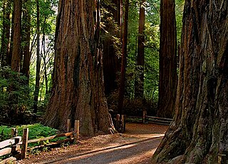
The Redwood National and State Parks (RNSP) are a complex of one national park and three state parks, cooperatively managed and located in the United States along the coast of northern California. Comprising Redwood National Park and California's State Parks—Del Norte Coast, Jedediah Smith, and Prairie Creek —the combined RNSP contain 139,000 acres (560 km2), and feature old-growth temperate rainforests. Located within Del Norte and Humboldt counties, the four parks protect 45 percent of all remaining coast redwood old-growth forests, totaling at least 38,982 acres (157.75 km2). The species is the tallest, among the oldest, and one of the most massive tree species on Earth. The parks also preserve other indigenous flora, fauna, grassland prairie, cultural resources, waterways, and 37 miles (60 km) of pristine coastline.

<span class="mw-page-title-main">Mount Tamalpais</span> Mountain in California, United States

Mount Tamalpais, known locally as Mount Tam, is a peak in Marin County, California, United States, often considered symbolic of Marin County. Much of Mount Tamalpais is protected within public lands such as Mount Tamalpais State Park, the Marin Municipal Water District watershed, and National Park Service land, such as Muir Woods.

<span class="mw-page-title-main">Henry Cowell Redwoods State Park</span> State park in Santa Cruz County, California, United States

Henry Cowell Redwoods State Park is a state park of California, United States, preserving mainly forest and riparian areas in the watershed of the San Lorenzo River, including a grove of old-growth coast redwood. It is located in Santa Cruz County, primarily in the area between the cities of Santa Cruz and Scotts Valley, near the community of Felton and the University of California at Santa Cruz. The park includes a non-contiguous extension in the Fall Creek area north of Felton. The 4,623-acre (1,871 ha) park was established in 1953.

<span class="mw-page-title-main">Mount Tamalpais State Park</span> Forested land preserve in Marin County, California

Mount Tamalpais State Park is a California state park, located in Marin County, California. The primary feature of the park is the 2,571 feet (784 m) Mount Tamalpais. The park contains mostly redwood and oak forests. The mountain itself covers around 25,000 acres (100 km2). There are about 60 miles (97 km) of hiking trails, which are connected to a larger, 200-mile (320 km) network of trails in neighboring public lands. The park received 564,000 visitors as of 2003. Muir Woods National Monument is surrounded by the state park.

<span class="mw-page-title-main">Portola Redwoods State Park</span> State park in Northern California

Portola Redwoods State Park is a 2,800 acres (1,100 ha) state park in California situated in San Mateo County. The parks' primary watercourses — Peters Creek, Pescadero Creek and their associated tributaries — converge at Portola Redwoods State Park. Tip Toe Falls is a small waterfall along Fall Creek, a tributary of Pescadero Creek.

<span class="mw-page-title-main">William Kent (American politician)</span> American politician

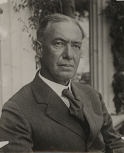
William Kent was an American politician, conservationist and philanthropist from Marin County, California. He served as a U.S. Representative from Northern California between 1911 and 1917, and was instrumental in the creation of Muir Woods National Monument.

<span class="mw-page-title-main">Samuel P. Taylor State Park</span> State park in California, United States

Samuel P. Taylor State Park is a state park located in Marin County, California, United States, which includes approximately 2,700 acres (11 km2) of redwood forest and grassland. The park contains about 600 acres (2.4 km2) of old-growth forest, some of which can be seen along the Pioneer Tree Trail.

<span class="mw-page-title-main">Theodore J. Hoover Natural Preserve</span>

Theodore J. Hoover Natural Preserve, which includes Waddell Marsh, is located at the mouth of Waddell Creek, a coastal freshwater marsh that is one of the rarest habitats on the Central Coast of California. This marsh is one of the few relatively undisturbed bodies of fresh water left along the West coast. The land is 23 acres of wetland habitat. It is part of the Rancho del Oso Big Basin Redwoods State Park, located approximately 65 miles south of San Francisco. The elevation in the park ranges from sea level to over 2,000 feet. The area was named after William W. Waddell, who established the last of his four sawmills there in 1868. The sawmill ran down after his death in 1875. All the boilers were left in the area; they are now completely surrounded by second-growth redwoods. Other trees found in the park are conifers, and oaks. Within the park there are different vegetation types to be seen, such as chaparral, redwood forests, and riparian habitats.

<span class="mw-page-title-main">Golden Gate Biosphere Network</span>

The Golden Gate Biosphere Network is a voluntary coalition of federal, state, and local government agencies, nonprofit organizations, universities, and private partners within the Golden Gate Biosphere region. The Network works towards protecting the biosphere region's biodiversity and conserving its natural resources to maintain the quality of life for people within the region. The Network has been part of the UNESCO Man and Biosphere Programme since 1988 and is part of the US Biosphere Network and EuroMAB. It is recognized by UNESCO due to the significant biodiversity of the region, as well as the Network's efforts to demonstrate and promote a balanced relationship between humans and the biosphere.

<span class="mw-page-title-main">Golden Gate National Recreation Area</span> U.S. National Recreation Area surrounding San Francisco Bay Area

The Golden Gate National Recreation Area (GGNRA) is a U.S. National Recreation Area protecting 82,116 acres (33,231 ha) of ecologically and historically significant landscapes surrounding the San Francisco Bay Area. Much of the park is land formerly used by the United States Army. GGNRA is managed by the National Park Service and is the second-most visited unit of the National Park system in the United States, with more than 15.6 million visitors in 2022. It is also one of the largest urban parks in the world, with a size two-and-a-half times that of the consolidated city and county of San Francisco.

<span class="mw-page-title-main">Prairie Creek Redwoods State Park</span> State park in Humboldt County, California, United States

Prairie Creek Redwoods State Park is a state park, located in Humboldt County, California, near the town of Orick and 50 miles (80 km) north of Eureka. The 14,000 acre (57 km²) park is a coastal sanctuary for old-growth Coast Redwood trees.

<span class="mw-page-title-main">Lagunitas Creek</span> Stream in California, United States

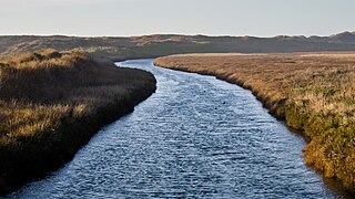
Lagunitas Creek is a 24 miles (39 km)-long northward-flowing stream in Marin County, California. It is critically important to the largest spawning runs of endangered coho salmon in the Central California Coast Coho salmon Evolutionary Significant Unit.

<span class="mw-page-title-main">Dr. Aurelia Reinhardt Redwood Regional Park</span> Park with large redwood grove in California

Dr. Aurelia Reinhardt Redwood Regional Park is a part of the East Bay Regional Parks District (EBRPD) in the San Francisco Bay Area. It is located in the hills east of Oakland. The park contains the largest remaining natural stand of coast redwood found in the East Bay. The park is part of a historical belt of coast redwood extending south to Leona Canyon Regional Open Space Preserve and east to Moraga.

<span class="mw-page-title-main">Redwood Creek (Marin County)</span> River in California, United States

Redwood Creek is a mostly perennial stream in Marin County, California. 4.7 miles (7.6 km) long, it drains a 7-square-mile (18 km2) watershed which includes the Muir Woods National Monument, and reaches the Pacific Ocean north of the Golden Gate at Muir Beach.

Founded in 1981, the Golden Gate National Parks Conservancy is a nonprofit cooperating association that supports park stewardship and conservation in the Golden Gate National Recreation Area—the most visited national park in the U.S.

<span class="mw-page-title-main">Marin Transit</span>

Marin Transit is a public bus agency in Marin County, California, in the United States. Originally formed in 1964 as Marin County Transit District (MCTD). Marin Transit was re-branded on 30 July 2007 and now provides a variety of fixed-route and demand-response services using contractors. In 2022, the system had a ridership of 2,628,800, or about 8,400 per weekday as of the second quarter of 2023.

<span class="mw-page-title-main">Pescadero Creek</span> River in California, United States

Pescadero Creek is a major stream in Santa Cruz and San Mateo counties in California, United States. At 26.6 miles (42.8 km), it is the longest stream in San Mateo County and flows all year from springs in the Santa Cruz Mountains. Its source is at 1,880 feet (570 m) above sea level on the western edge of Castle Rock State Park, with additional headwaters in Portola Redwoods State Park, and its course traverses Pescadero Creek County Park and San Mateo County Memorial Park before entering Pescadero Marsh Natural Preserve at Pescadero State Beach and thence to the Pacific Ocean 14.4 miles (23 km) south of Half Moon Bay.

<span class="mw-page-title-main">Redwood Creek Native Plant Nursery</span>

Redwood Creek Native Plant Nursery was located just outside the old-growth redwood forest at Muir Woods National Monument. The nursery provided plants for restoration of the creek bank in the lower watershed and impacted areas of the Muir Woods' redwood understory. It was moved to that location in 1992, and closed in 2015.

The Watershed Alliance of Marin is a 501(c)(3) non-profit network of organizations with a shared purpose of preserving the watersheds of Marin County, California.

References

  1. "Listing of acreage – December 31, 2011" (XLSX). Land Resource Division, National Park Service. Retrieved March 23, 2012. (National Park Service Acreage Reports)
  2. "NPS Annual Recreation Visits Report". National Park Service. Retrieved August 2, 2023.
  3. "National Register Information System". National Register of Historic Places . National Park Service. July 9, 2010.
  4. "Muir Woods Tour Manual – 2008" (PDF). National Park Service . Retrieved January 19, 2009.
  5. Bolsinger, Charles L.; Waddell, Karen L. (1993). "Area of old-growth forests in California, Oregon, and Washington" (PDF). United States Forest Service, Pacific Northwest Research Station. Resource Bulletin PNW-RB-197.
  6. "NPS: Learn about the park". National Park Service . Retrieved July 1, 2022.
  7. "Fog, Redwoods and a Changing Climate". National Park Service . Retrieved July 1, 2022.
  8. "NASA Earth Observations Data Set Index". NASA. Retrieved January 30, 2016.
  9. Official Series Description - CENTISSIMA Series. Soilseries.sc.egov.usda.gov. Retrieved on July 21, 2013.
  10. "Geologic map and map database of parts of Marin, San Francisco, Alameda, Contra Costa, and Sonoma Counties, California". ngmdb.usgs.gov. Retrieved March 15, 2018.
  11. "SoilWeb: An Online Soil Survey Browser - California Soil Resource Lab". casoilresource.lawr.ucdavis.edu. Retrieved March 15, 2018.
  12. Binkley, Cameron (2005). "A Cult of Beauty: The Public Life and Civic Work of Laura Lyon White". California History. 82 (2): 56–57. doi:10.2307/25161804. JSTOR   25161804.
  13. William Kent - People - John Muir Exhibit. Sierraclub.org (April 5, 1976). Retrieved on 2013-07-21.
  14. 1 2 "Kent Tree Falls". Natural Resources at Muir Woods NM. 2003. Archived from the original on December 23, 2006. Retrieved July 11, 2015.
  15. "National Register Information System". National Register of Historic Places . National Park Service. March 13, 2009.
  16. Muir Woods National Monument - Muir Woods National Monument. Nps.gov (June 23, 2013). Retrieved on 2013-07-21.
  17. Carlisle, S.; M. Reichmuth; E. Brown; S. C. Del Real (2008). Long-term coho salmon and steelhead trout monitoring in coastal Marin County 2007: annual monitoring progress report. Natural Resource Technical Report NPS/SFAN/NRTR—2009/269 (PDF) (Report). Fort Collins, Colorado: National Park Service. Archived from the original (PDF) on May 27, 2010. Retrieved January 5, 2010.
  18. Michelle O'Herron (August 2009). "Coho Salmon Monitoring in Redwood Creek, Inventory and Monitoring Program Research Project Summary" (PDF). National Park Service. Archived from the original (PDF) on May 28, 2010. Retrieved January 5, 2009.
  19. 1 2 Peter Fimrite (November 12, 2010). "Marin creek being restored to bring back coho". San Francisco Chronicle. Retrieved November 14, 2010.
  20. 2010-2011 Coho and Steelhead Spawner Survey Summary (Report). National Park Service. Retrieved May 15, 2011.
  21. Mark Prado (January 2, 2010). "Marin's coho salmon on the brink of extinction". Marin Independent Journal. Retrieved January 12, 2010.
  22. Donna Whitmarsh (January 2010). "California Coho Salmon In Dire Straits, New Report Predicts Collapse". Bay Nature. Retrieved January 12, 2010.
  23. "Muir Woods coho salmon vanish, fanning fears of extinction". sfgate.com. November 30, 2014. Retrieved March 15, 2018.
  24. The Birds of Muir Woods National Monument. Muir Woods National Monument – Birds, U.S. National Park Service. Last updated in September 2001. Accessed August 9, 2010.
  25. "Wildlife Checklist: Muir Woods National Monument" (PDF). National Park Service. Retrieved July 6, 2020.
  26. Muir Woods National Monument (Official Map & Guide). National Park Service. Retrieved June 29, 2010.
  27. 1 2 Nolte, Carl (July 10, 2015). "Wildly popular Muir Woods to start requiring reservations". San Francisco Chronicle. Retrieved July 11, 2015.
  28. "Muir Woods National Monument". National Park Service. Retrieved January 1, 2016.
  29. "Reservations - Muir Woods National Monument (U.S. National Park Service)". www.nps.gov. Retrieved November 12, 2017.
  30. "Eating & Sleeping - Muir Woods National Monument (U.S. National Park Service)". www.nps.gov. Retrieved May 13, 2020.
  31. "Hiking Trails - Muir Woods National Monument (U.S. National Park Service)". www.nps.gov. Retrieved March 15, 2018.
  32. "Things To Do - Muir Woods National Monument (U.S. National Park Service)". www.nps.gov. Retrieved November 11, 2016.
  33. "Special Park Use Permits - Golden Gate National Recreation Area (U.S. National Park Service)". www.nps.gov. Retrieved March 15, 2018.
  34. Building 201, Mailing Address: Golden Gate National Recreation Area; Francisco, Fort Mason San; Us, CA 94123-0022 Phone:561-4700 Contact. "Tourism to Golden Gate National Park Units Contributes $1.6 billion in Economic Benefits - Golden Gate National Recreation Area (U.S. National Park Service)". www.nps.gov. Retrieved March 12, 2020.
  35. Catherine Cullinane Thomas; Lynne Koontz; Egan Cornachione (May 2019). "2018 National Park Visitor Spending Effects" (PDF). National Park Service.
  36. "Muir Woods neighbors, rangers clash over parking". Marin Independent Journal. December 14, 2019. Retrieved March 12, 2020.
  37. "Muir Woods neighbors, rangers clash over parking". Marin Independent Journal. December 14, 2019. Retrieved March 21, 2020.
  38. "State of the Park - Muir Woods National Monument". National Parks Conservation Association.
  39. Valley, Mailing Address: Muir Woods National Monument 1 Muir Woods Rd Mill; Us, CA 94941 Phone:561-2850 Contact. "Redwood Creek Restoration at Muir Beach - Muir Woods National Monument (U.S. National Park Service)". www.nps.gov. Retrieved March 21, 2020.
  40. Watkins, Charles (2014). Trees, Woods and Forests: A Social and Cultural History. Reaktion Books. p. 225. ISBN   978-1-78023-415-1.
  41. "Rise of the Planet of the Apes (2011)" . Retrieved March 15, 2018 via www.imdb.com.
  42. "Dawn of the Planet of the Apes (2014)" . Retrieved March 15, 2018 via www.imdb.com.