Related Research Articles
Rancho Mirage is a city in Riverside County, California, United States. The population was 16,999 at the 2020 census, down from 17,218 at the 2010 census, but the seasonal (part-time) population can exceed 20,000. Incorporated in 1973 and located between Cathedral City and Palm Desert, it is one of the nine cities of the Coachella Valley.

Thousand Palms is a census-designated place (CDP) in the Coachella Valley of Riverside County, California, United States. The population was 7,715 at the 2010 census, up from 5,120 at the 2000 census.

The Sonoran Desert is a hot desert in North America and ecoregion that covers the northwestern Mexican states of Sonora, Baja California, and Baja California Sur, as well as part of the southwestern United States. It is the hottest desert in both Mexico and the United States. It has an area of 260,000 square kilometers (100,000 sq mi).

Anza-Borrego Desert State Park is a California State Park located within the Colorado Desert of southern California, United States. The park takes its name from 18th century Spanish explorer Juan Bautista de Anza and borrego, a Spanish word for sheep. With 585,930 acres (237,120 ha) that includes one-fifth of San Diego County, it is the largest state park in California and the second biggest park nationally.

The Low Desert is a common name for any desert in California that is under 2,000 feet in altitude. These areas include, but are not exclusive to, the Colorado Desert and Yuha Desert, in the Southern California portion of the Sonoran Desert. These areas are distinguished in biogeography from the adjacent northern High Desert or Mojave Desert by latitude, elevation, animal life, climate, and native plant communities.

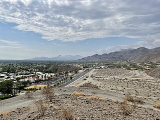
The Coachella Valley is an arid rift valley in the Colorado Desert of Southern California in Riverside County. The valley may also be referred to as Greater Palm Springs and the Palm Springs Area due to the prominence of the city of Palm Springs and disagreement over the name Coachella. The valley extends approximately 45 mi (72 km) southeast from the San Gorgonio Pass to the northern shore of the Salton Sea and the neighboring Imperial Valley, and is approximately 15 mi (24 km) wide along most of its length. It is bounded on the northeast by the San Bernardino and Little San Bernardino Mountains, and on the southwest by the San Jacinto and Santa Rosa Mountains.

Colorado Desert is a part of the larger Sonoran Desert located in California, United States and Baja California, Mexico. It encompasses approximately 7 million acres, including the heavily irrigated Coachella, Imperial and Mexicali valleys. It is home to many unique flora and fauna.
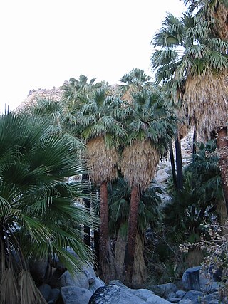
Washingtonia filifera, the desert fan palm, California fan palm, or California palm, is a flowering plant in the palm family Arecaceae, native to the far southwestern United States and Baja California, Mexico. Growing to 15–20 m (49–66 ft) tall by 3–6 m (10–20 ft) broad, it is an evergreen monocot with a tree-like growth habit. It has a sturdy, columnar trunk and waxy, fan-shaped (palmate) leaves.

The Coachella Valley fringe-toed lizard is a species of phrynosomatid lizard.

The Living Desert Zoo and Gardens, formerly the Living Desert Museum, is a non-profit zoo and desert botanical garden located in Palm Desert, Riverside County, California, United States. The Living Desert is home to over 500 animals representing over 150 species and welcomes over 500,000 visitors annually. Situated in the Sonoran Desert of the Coachella Valley and Santa Rosa Mountains foothills near Palm Springs, California, The Living Desert is set on 1,200 acres, with 80 developed as zoo and gardens.

The Santa Rosa and San Jacinto Mountains National Monument is a National Monument in southern California. It includes portions of the Santa Rosa and San Jacinto mountain ranges, the northernmost ones of the Peninsular Ranges system. The national monument covers portions of Riverside County, west of the Coachella Valley, approximately 100 miles (160 km) southeast of downtown Los Angeles.
The Indio Hills are a low mountain range in the Colorado Desert. located in Riverside County, California's Coachella Valley. The hills were named for their proximity to the city of Indio, and are sometimes referred to as the Indio Mud Hills or Indio Sand Hills.

The Santa Rosa Wilderness is a 72,259-acre (292.42 km2) wilderness area in Southern California, in the Santa Rosa Mountains of Riverside and San Diego counties, California. It is in the Colorado Desert section of the Sonoran Desert, above the Coachella Valley and Lower Colorado River Valley regions in a Peninsular Range, between La Quinta to the north and Anza Borrego Desert State Park to the south. The United States Congress established the wilderness in 1984 with the passage of the California Wilderness Act, managed by both the US Forest Service and the Bureau of Land Management. In 2009, the Omnibus Public Land Management Act was signed into law which added more than 2,000 acres (8.1 km2). Most of the Santa Rosa Wilderness is within the Santa Rosa and San Jacinto Mountains National Monument.

The Sonny Bono Salton Sea National Wildlife Refuge is located in the Imperial Valley of California, 40 miles (64 km) north of the Mexican border. Situated at the southern end of the Salton Sea, the refuge protects one of the most important nesting sites and stopovers along the Pacific Flyway. Despite its location in the Colorado Desert, a subdivision of the larger Sonoran Desert, the refuge contains marine, freshwater, wetland, and agricultural habitats which provide sanctuary for hundreds of birds and wetland species, including several that have been listed as endangered or sensitive by the U.S. Fish and Wildlife Service.

Cibola National Wildlife Refuge is a U.S. National Wildlife Refuge in the floodplain of the lower Colorado River between Arizona and California and surrounded by a fringe of desert ridges and washes. The refuge encompasses both the historic Colorado River channel as well as a channelized portion constructed in the late 1960s. Along with these main waterbodies, several important backwaters are home to many wildlife species that reside in this Yuma Desert portion of the Sonoran Desert. Because of the river's life-sustaining water, wildlife here survive in an environment that reaches 120 °F (49 °C) in the summer and receives an average of only 2 inches (5.1 cm) of rain per year.

Havasu National Wildlife Refuge is a U.S. National Wildlife Refuge on the lower Colorado River in Arizona and California. It preserves habitat for desert bighorn sheep, the endangered southwestern willow flycatcher, and other animals. The refuge protects 30 river miles - 300 miles (480 km) of shoreline - from Needles, California, to Lake Havasu City, Arizona. One of the last remaining natural stretches of the lower Colorado River flows through the 20-mile-long (32 km) Topock Gorge.
Coachella Valley National Wildlife Refuge is a 3,709-acre (15.01 km2) protected area in Riverside County, California's Coachella Valley. It lies within the unincorporated community of Thousand Palms, just north of Palm Desert. The refuge contains the majority of critical habitat for the Coachella Valley Fringe-toed Lizard within the Coachella Valley Preserve and Indio Hills Palms State Reserve.

Flora of the Colorado Desert, located in Southern California. The Colorado Desert is a sub-region in the Sonoran Desert ecoregion of southwestern North America. It is also known as the Low Desert, in contrast to the higher elevation Mojave Desert or High Desert, to its north.

Sand to Snow National Monument is a U.S. National Monument located in San Bernardino County and northern Riverside County, Southern California.
References
- ↑ http://coachellavalleypreserve.org/fanpalm.html Archived 2010-04-29 at the Wayback Machine . accessed 6/20/2010