
Southern California is a geographic and cultural region that generally comprises the southern portion of the U.S. state of California. It includes the Los Angeles metropolitan area as well as the Inland Empire. The region generally contains ten of California's 58 counties: Imperial, Kern, Los Angeles, Orange, Riverside, San Bernardino, San Diego, Santa Barbara, San Luis Obispo and Ventura counties.

Tupman is a census-designated place (CDP) in Kern County, California, United States. Tupman is located 20 miles (32 km) west-southwest of Bakersfield, at an elevation of 331 feet (101 m). The population was 161 at the 2010 census, down from 227 at the 2000 census.

Tulare Lake or Tache Lake is a freshwater lake in the southern San Joaquin Valley, California, United States. Historically, Tulare Lake was once the largest freshwater lake west of the Mississippi River. For thousands of years, from the Paleolithic onward, Tulare Lake was a uniquely rich area, which supported perhaps the largest population of Native Americans north of present-day Mexico.

Point Reyes National Seashore is a 71,028-acre (287.44 km2) park preserve located on the Point Reyes Peninsula in Marin County, California. As a national seashore, it is maintained by the US National Park Service as an important nature preserve. Some existing agricultural uses are allowed to continue within the park. Clem Miller, a US Congressman from Marin County, wrote and introduced the bill for the establishment of Point Reyes National Seashore in 1962 to protect the peninsula from development which was proposed at the time for the slopes above Drake's Bay.

Antelope Valley California Poppy Reserve is a state-protected reserve of California, United States, harboring the most consistent blooms of California poppies, the state flower. The reserve is located in the rural west side of Antelope Valley in northern Los Angeles County, 15 miles (24 km) west of Lancaster. To the north is Kern County. The reserve is at an elevation ranging from 2,600 to 3,000 feet above sea level, in the Mojave Desert climate zone. The reserve is administered by the California Department of Parks and Recreation. Other wildflowers within the reserve include the Owl's Clover, Lupine, Goldfields, Cream Cups and Coreopsis.

Arthur B. Ripley Desert Woodland State Park is a state park in the western Antelope Valley in Southern California. The park protects mature stands of Joshua trees and California juniper trees in their western Mojave Desert habitat.

The Antelope Valley is located in northern Los Angeles County, California, United States, and the southeast portion of California's Kern County, and constitutes the western tip of the Mojave Desert. It is situated between the Tehachapi, Sierra Pelona, and the San Gabriel Mountains. The valley was named for the pronghorns that roamed there until they were all eliminated in the 1880s, mostly by hunting, or resettled in other areas. The principal cities in the Antelope Valley are Palmdale and Lancaster.

The San Joaquin Valley is the southern half of California's Central Valley. Famed as a major breadbasket, the San Joaquin Valley is an important source of food, producing a significant part of California's agricultural output.

The eastern elk is an extinct subspecies or distinct population of elk that inhabited the northern and eastern United States, and southern Canada. The last eastern elk was shot in Pennsylvania on September 1, 1877. The subspecies was declared extinct by the United States Fish and Wildlife Service in 1880. Another subspecies of elk, the Merriam's elk, also became extinct at roughly the same time.

The Roosevelt elk, also known commonly as the Olympic elk and Roosevelt's wapiti, is the largest of the four surviving subspecies of elk in North America by body mass. Mature bulls weigh from 700 to 1,200 lb. with very rare large bulls weighing more. Its geographic range includes temperate rainforests of the Pacific Northwest including parts of northern California. It was introduced to Alaska's Afognak, Kodiak, and Raspberry Islands in 1928 and reintroduced to British Columbia's Sunshine Coast from Vancouver Island in 1986.

The Jawbone–Butterbredt Area of Critical Environmental Concern (ACEC), is located in the Mojave Desert and Southern Sierra Nevada, northwest of California City and California State Route 14, in Kern County, California.
Fort Hunter Liggett is a United States Army post in Jolon, California, in southern Monterey County, California. The fort, named in 1941 after General Hunter Liggett, is primarily used as a training facility, where activities such as field maneuvers and live fire exercises are performed. It is roughly 25 miles northwest of Camp Roberts, California.
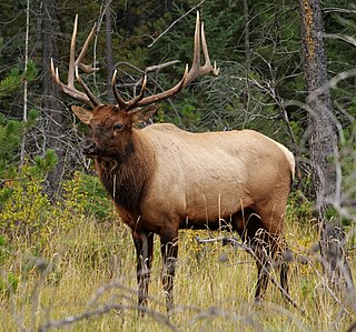
The elk, or wapiti, is the second largest species within the deer family, Cervidae, and one of the largest terrestrial mammals in its native range of North America and Central and East Asia. The word "elk" originally referred to the European variety of the moose, Alces alces, but was transferred to Cervus canadensis by North American colonists. The name "wapiti" derives from a Shawnee and Cree word meaning "white rump" for the distinctive light fur in the rear region, just like the Bighorn Sheep.

Purisima Creek is an 8.0-mile-long (12.9 km) stream in San Mateo County, California which rises 1.3 miles (2.1 km) north of Sierra Morena, a mountain in the Santa Cruz Mountains, and flows westward to the Pacific Ocean 2.3 miles (3.7 km) south-southeast of Miramontes Point. Much of its watershed has been incorporated in the Purisima Creek Redwoods Open Space Preserve.

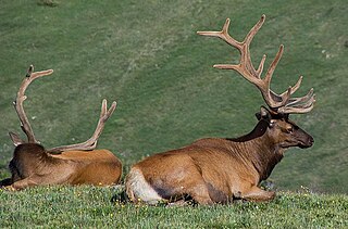
The tule elk is a subspecies of elk found only in California, ranging from the grasslands and marshlands of the Central Valley to the grassy hills on the coast. The subspecies name derives from the tule, a species of sedge native to freshwater marshes on which the tule elk feeds. When the Europeans first arrived, an estimated 500,000 tule elk roamed these regions, but by 1870 they were thought to be extirpated. However, in 1874–1875 a single breeding pair was discovered in the tule marshes of Buena Vista Lake in the southern San Joaquin Valley. Conservation measures were taken to protect the species in the 1970s. Today, the wild population exceeds 4,000. Tule elk can reliably be found in Carrizo Plain National Monument, Point Reyes National Seashore, portions of the Owens Valley from Lone Pine to Bishop, on Coyote Ridge in Santa Clara Valley, San Jose, California and in Pacheco State Park and areas surrounding San Luis Reservoir near Los Banos, California.
The Rocky Mountain elk is a subspecies of elk found in the Rocky Mountains and adjacent ranges of Western North America.
The Phillip Burton Wilderness is part of the 111 sq. mile (288 km2) Point Reyes National Seashore located about 20 miles (32 km) northeast of San Francisco, California. Total wilderness land is 33,373 acres which includes a roadless "potential wilderness" area of over 8,000 acres (32 km2) and is one of only three designated wilderness along the California coast, the others being the King Range Wilderness and the Rocks and Islands Wilderness. The National Park Service manages the wilderness.

Santa Clara County, officially the County of Santa Clara, is the sixth-most populous county in the U.S. state of California, with a population of 1,936,259, as of the 2020 census. Santa Clara County and neighboring San Benito County together form the U.S. Census Bureau's San Jose–Sunnyvale–Santa Clara metropolitan statistical area, which is part of the larger San Jose–San Francisco–Oakland combined statistical area. Santa Clara is the most populous county in the San Francisco Bay Area and in Northern California. The county seat and largest city is San Jose; with about 1,000,000 residents, it is the 10th-most populous city in the United States, California's third-most populous city and the most populous city in the San Francisco Bay Area. The second- and third-largest cities are Sunnyvale and Santa Clara.
San Antonio Creek is a 24.4-kilometre-long (15.2 mi) northwesterly-flowing stream originating on the eastern edge of Santa Clara County just west of its border with Stanislaus County.
Cañada de los Osos is an 8 miles (13 km) stream that flows west and then north to join Coyote Creek in the Diablo Range south of Henry Coe State Park in southern Santa Clara County, California, United States. It is now protected within the 5,800 acre Cañada de los Osos Ecological Preserve, managed by the California Department of Fish and Wildlife about 10 miles (16 km) east of Gilroy, California.
