
Almaden Quicksilver County Park is a 4,163 acres (17 km2) park that includes the grounds of former mercury ("quicksilver") mines adjacent to south San Jose, California, USA. The park's elevation varies greatly: the most used entrances are less than 600 feet above sea level, while the highest point in the park is over 1,700 feet above sea level.

South San Jose is the southern region of San Jose, California. The name "South Side" refers to an area bounded roughly by Hillsdale Avenue and Capitol Expressway to the North, Camden Avenue to the West, Highway 101 and Hellyer Avenue on the east, the border with the city of Morgan Hill towards the south, and Los Gatos, to the west.

Uvas Canyon County Park is a 1,147-acre (464 ha) natural park located in upper Uvas Canyon on the eastern side of the Santa Cruz Mountains, west of Morgan Hill, California. The park has several small waterfalls, some of which flow perennially, that feed into tributaries confluent with Uvas Creek. The park is part of the Santa Clara County Parks System, and facilitates picnics, hiking and overnight camping. It is one of the few parks in the area that allows dogs in the campgrounds.

The Alameda is a historic district of Central San Jose, California, west of Downtown San Jose. The district is centered on an alameda, a historic portion of El Camino Real connecting Downtown San Jose to Mission Santa Clara de Asís, and includes the smaller, surrounding neighborhoods to the north and east, like College Park and St. Leo's.
Chemeketa Park is an unincorporated community of approximately 150 homes located in Lexington Hills, in the Santa Cruz Mountains in Santa Clara County, California, that is now effectively a rural neighborhood of Los Gatos, California. The postal designation for Chemeketa Park is "Los Gatos 95033", although it lies approximately five miles South of the official boundaries of the incorporated town of Los Gatos. The community is in area codes 408 and 669.

Agnews Developmental Center was a psychiatric and medical care facility, located in Santa Clara, California.

Bell Station is an unincorporated community located along State Route 152 between Casa de Fruta and Pacheco Pass near the southeast extent of Santa Clara County, California.

Sanborn County Park is a 3,453 acre (13.97 km2) county park situated in the Santa Cruz Mountains, managed by the Santa Clara County Parks and Recreation Department. The deeply forested park features over 15 miles of trails, second-growth redwoods, and creeks that flow year-round. It offers hiking, RV camping, walk-in campsites, and picnicking/BBQ sites. In the summer months, Sanborn County Park hosts the only outdoor Shakespearean company in Silicon Valley.
El Rancho Rinconada de los Gatos was a 6,631-acre (26.83 km2) Mexican land grant in present-day Santa Clara County, California made in 1840 by Governor Juan Alvarado to Jose Maria Hernandez and Sebastian Fabian Peralta. Located in the southern San Francisco Bay Area, the grant included present-day Los Gatos and Monte Sereno, along with about a third of Campbell. It also included small sections of present-day San Jose, Saratoga and unincorporated Santa Clara County. Los Gatos Creek flowed through the center of the rancho. The name means "corner of the cats" and is derived from the cougars that are still present in the nearby hills, as well as the "corner" formed by the narrowing gap between El Sereno and El Sombroso mountains.

Joseph D. Grant County Park is the largest county park in Santa Clara County, California. Also known as Grant Ranch Park, this site is situated in the Diablo Range foothills of the eastern Santa Clara Valley. The park is one of 28 owned by Santa Clara County and managed by the Santa Clara County Parks and Recreation Department.

Santa Teresa County Park is an 1,673-acre (6.77 km2) park in the Santa Teresa neighborhood of San Jose, California, located within the Santa Teresa Hills

Santa Clara Valley is an American Viticultural Area (AVA) located mostly in Santa Clara County, California. The area served an important role in the early history of California wine and was home to the pioneer winemakers Paul Masson and Charles Lefranc. It was established on April 27, 1989 by the Bureau of Alcohol, Tobacco and Firearms (ATF), Treasury after evaluating the petition proposing a viticultural area in Santa Clara, San Benito, San Mateo and Alameda Counties that extends from lower San Francisco Bay with the cities of San Jose, Santa Clara, Menlo Park, Mountain View and Fremont toward the southern boundary near Gilroy and Morgan Hill, outlining the viticultural area named "Santa Clara Valley." It includes the historic winegrowing areas of Santa Clara County not already within the [Santa Cruz Mountains viticultural area, plus the area near Mission San José in Alameda County and a small part of San Benito County. Santa Clara Valley encompasses the established viticultural areas, Pacheco Pass and San Ysidro District.

Los Gatos Creek Park is a county park in Campbell, California, a town that is bisected by the Los Gatos Creek. The park is operated by the Santa Clara County Parks and Recreation Department.
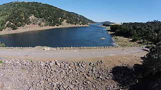
Coyote Dam is a 140-foot (43 m) high, 980-foot (300 m) long, earth and rock dam built in 1936 in Santa Clara County, California, United States, located north of Gilroy.

Rancho San Luis Gonzaga was a 48,821-acre (197.57 km2) Mexican land grant in the Diablo Range, in present-day Santa Clara County and Merced County, California given in 1843 by Governor Manuel Micheltorena to Juan Carlos Pacheco and José Maria Mejía. The grant was bounded by Francisco Pérez Pachecos Rancho Ausaymas y San Felipe on the west, the San Joaquin River and San Joaquin Valley on the east, and Los Baños Creek on the south.

Hellyer County Park is one of 28 Santa Clara County Parks. The park is located just off of Highway 101 in San Jose, California, United States. The 178-acre (72 ha) park is home to Hellyer Park Velodrome and Cottonwood Lake. Other recreational opportunities at the park include picnicking, hiking, fishing, biking, and a playground. Coyote Creek Parkway is a multi-use trail that is paved for 15 miles (24 km) south to Anderson Lake County Park. Coyote Creek Parkway is a jurisdiction of the Santa Clara County Parks. Coyote Creek Trail continues to the north along Coyote Creek under the jurisdiction of San Jose city parks.

Santa Clara County Parks and Recreation Department, sometimes referred to as Santa Clara County Parks Department or Santa Clara County Parks, is a government department in Santa Clara County, California. The department manages 28 parks with a total area over 52,000 acres (21,000 ha).

Communications Hill is a neighborhood located in the San Juan Bautista Hills of San Jose, California.

The Santa Clara County Fairgrounds is an event venue in San Jose, California. The 165-acre (67 ha) fairgrounds has been owned by the County of Santa Clara since 1940 and is operated by the Santa Clara County Fairgrounds Management Corporation, a public-benefit nonprofit corporation.