Circle of Palms Plaza

Last updated

Circle of Palms Plaza
Kluft-photo-Circle-of-Palms-San-Jose-April-2008-Img 0778.jpg
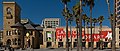
Circle of Palms Plaza with the Fairmont San Jose and Fairmont Plaza
Location map San Jose.png
Area2.3-acre (9,000 m²)
Location San Jose, California
Site of California's First State Capital
Official nameSite of California's First State Capital [1]
DesignatedAugust 30, 1950
Reference no.461

The Circle of Palms Plaza is located in downtown San Jose, California. It is composed of a ring of palm trees encircling a California State Seal, and designates the California Historical Marker 461, the site of California's first state capital from 1849 to 1851.

Contents

History

When California became part of the US in 1850, San Jose was the oldest civilian settlement dating back to its establishment in 1777, and selected the first official state capital of California. [2] [3] A two-story adobe hotel built around 1830 became the first state capitol and hosted the first legislative sessions in 1850 and 1851. [4] The capitol site is designated as California Historical Marker 461. From 1866 to 1887, the Market Street Chinatown occupied the entire block. The settlement was the center of Chinese-American life in the Santa Clara Valley, until it was destroyed by arson. The site was redeveloped into a plaza in the 1980s.

Description

The Circle of Palms Plaza is a ring of palm trees encircling a California State Seal, located between the Fairmont San Jose Hotel, the KQED building (Silicon Valley Financial Center) and the San Jose Museum of Art. [5] [6] The concrete around the state seal contains quotes from the 1849 state constitutional convention in Monterey where San Jose was chosen as the capital.

Public activities

Each Winter, the San Jose Downtown Association sets up an outdoor ice rink called "San Jose Downtown Ice" at the Circle of Palms. [7]

Landmark status

On August 30, 1950, the State Historic Preservation Office designated the site of California's first state capital as a California historical landmark #461. A description on the commemorative plaque reads: " Directly opposite this tablet was located the first State Capitol Building, in which California's first Legislature assembled in December 1849. San Jose was the seat of government from 1849 to 1851." [1]

See also

Related Research Articles

<span class="mw-page-title-main">San Jose, California</span> City in California, United States

San Jose, officially the City of San José, is the largest city in Northern California by both population and area. With a 2022 population of 971,233, it is the most populous city in both the Bay Area and the San Jose–San Francisco–Oakland Combined Statistical Area, which has a 2015 population of 7.7 million and 9.7 million people respectively, the third-most populous city in California after Los Angeles and San Diego, and the 12th-most populous in the United States. Located in the center of the Santa Clara Valley on the southern shore of San Francisco Bay, San Jose covers an area of 179.97 sq mi (466.1 km2). San Jose is the county seat of Santa Clara County and the main component of the San Jose–Sunnyvale–Santa Clara Metropolitan Statistical Area, with an estimated population of around two million residents in 2018.

<span class="mw-page-title-main">Great Seal of California</span> Official government emblem of the U.S. state of California

The Great Seal of the State of California was adopted at the California state Constitutional Convention of 1849 and has undergone minor design changes since then, the last being the standardization of the seal in 1937. The seal shows Athena in Greek mythology, the goddess of wisdom and war, because she was born an adult, and California was never a territory; a California grizzly bear, the official state animal, feeding on grape vines, representing California's wine production; a sheaf of grain, representing agriculture; a miner, representing the California Gold Rush and the mining industry; and sailing ships, representing the state's economic power. The word Eureka, meaning "I have found it", is the California state motto.

<span class="mw-page-title-main">Signia by Hilton San Jose</span> Building in the United States

The Signia by Hilton San Jose is an 805-room high-rise hotel at 170 South Market Street in San Jose, California, located on the Plaza de César Chávez in Downtown San Jose. The hotel opened on April 7, 2022.

<span class="mw-page-title-main">Plaza de César Chávez</span> Public plaza in San Jose, California

The Plaza de César Chávez is an urban plaza and park in Downtown San Jose, California. The plaza's origins date to 1797 as the plaza mayor of the Spanish Pueblo de San José de Guadalupe, making it the oldest public space in Northern California. The plaza was rededicated after Californian civil rights activist César Chávez in 1993.

<span class="mw-page-title-main">San Jose Museum of Art</span> Contemporary art museum in San Jose, California, U.S.

The San José Museum of Art (SJMA) is a modern and contemporary art museum in downtown San Jose, California, United States. Founded in 1969, the museum holds a permanent collection with an emphasis on West Coast artists of the 20th and 21st centuries. It is located at Circle of Palms Plaza, beside Plaza de César Chávez. A member of North American Reciprocal Museums, SJMA has received several awards from the American Alliance of Museums.

<span class="mw-page-title-main">Downtown San Jose</span> Central business district in California, United States

Downtown San Jose is the central business district of San Jose, California, United States. Downtown is one of the largest tech clusters in Silicon Valley, as well as the cultural and political center of San Jose.

<span class="mw-page-title-main">Florida State Capitol</span> State capitol building of the U.S. state of Florida

<span class="mw-page-title-main">Monterey State Historic Park</span> United States historic place

Monterey State Historic Park is a historic state park in Monterey, California. It includes part or all of the Monterey Old Town Historic District, a historic district that includes 17 contributing buildings and was declared a National Historic Landmark in 1970. The grounds include California's first theatre, and the Monterey Custom House, where the American flag was first raised over California.

In many countries, kilometre zero or similar terms in other languages denote a particular location from which distances are traditionally measured and some use this as their official country location or coordinates for faster search at space satellites, this is also used for measuring distances between different countries around the world. Historically, they were markers where drivers could set their odometers to follow the directions in early roaming guide books.

<span class="mw-page-title-main">Downtown Santa Ana</span> United States historic place

Downtown Santa Ana (DTSA), also called Downtown Orange County, is the city center of Santa Ana, the county seat of Orange County, California. It is the institutional center for the city of Santa Ana as well as Orange County, a retail and business hub, and has in recent years developed rapidly as a regional cultural, entertainment, and culinary center for Orange County.

<span class="mw-page-title-main">San Jose City Hall</span> Seat of the municipal government of San Jose, California

San José City Hall is the seat of the municipal government of San Jose, California. Located in Downtown San Jose, it was designed by Pritzker Prize-winning architect Richard Meier in a Postmodern style. It consists of an 18-story tower, an iconic glass rotunda, and a city council chamber wing, laid out within a two-block-long public square known as San José Civic Plaza. The tower rises 285 feet (87 m) above the plaza, making it the fourth tallest building in San Jose.

The following is a timeline of the history of the city of Sacramento, California, United States.

The following is a timeline of the history of San Jose, California, United States.

<span class="mw-page-title-main">Historic Hotels of America</span> National Trust for Historic Preservation program

Historic Hotels of America is a program of the National Trust for Historic Preservation that was founded in 1989 with 32 charter members; the program accepts nominations and identifies hotels in the United States that have maintained their authenticity, sense of place, and architectural integrity.

<span class="mw-page-title-main">Sacramento First Courthouse</span> Historical Landmark in Sacramento, United States

Sacramento First Courthouse also, Former California State Capitol site, is historical site in Sacramento, California. The Courthouse was also the first and second California State Capitol. The site is California Historical Landmark No. 869, registered on January 11, 1974. At the northwest corner of 7th Street and I Street, 651 I Street, Sacramento was a building that served as California's State Capitol. The first period was January 16, 1852 to May 4, 1852, and the second period was from March 1, 1854, to May 15, 1854, with the California State Legislature third and fifth sessions. The 651 I Street building was the Sacramento County courthouse. The site of former California State Capitol - Sacramento County courthouse is now the Main Sacramento County Jail built in 1989. A California Historical marker was place at the site in 2007 by California State Parks working the Sacramento Trust for Historic Preservation.

<span class="mw-page-title-main">Murphy's Corral</span> Historical Landmark in Elk Grove, United States

Murphy's Ranch, also called Murphy's Corral, is a historical site in Elk Grove, California in Sacramento County. The site of Murphy's Ranch is a California Historical Landmark No. 680 listed on May 11, 1959. At Murphy's Ranch on June 10, 1846, was the start of the Bear Flag Revolt and Bear Flag Rebellion.

<span class="mw-page-title-main">San Diego Viejo Plaza</span> Historical Landmark in San Diego, California, United States

San Diego Viejo Plaza,, also called Plaza de Las Armas, Old Town Plaza, Washington Square, is a historical site in San Diego, California. San Diego Viejo Plaza site is a California Historical Landmark No. 63, listed on December 5, 1932. The plaza was the center of Pueblo de San Diego founded in 1835 in Alta California.

<span class="mw-page-title-main">First Presbyterian Church of Benicia</span> Historical place in Solano County, United States

First Presbyterian Church of Benicia was founded on April 15, 1849, at a building in Benicia, California in Solano County, California. The Presbyterian Church of Benicia site is a California Historical Landmark No. 175 listed on March 6, 1935. The First Presbyterian Church of Benicia was the first Protestant church founded in California with a staff pastor. The pastor was Reverend Sylvester Woodbridge Jr., who founded the church in 1849 using a school house. Woodbridge came to California in 1848. First Presbyterian Church built a building that was dedicated on March 9, 1851. Woodbridge was the pastor till 1869, when he moved to San Francisco. The Presbyterian California Gold Rush church ended in 1875. The Church became a One-room school and most the members moved to the First Congregational Church of Benicia founded in 1865. Later the church-school building became an Episcopal Church. The Episcopal Church soon built a larger church. The 1851 church was remove and the land became Benicia City Park.

Market Street Chinatown or Plaza Chinatown refers to two successive Chinatowns in San Jose, California, during the 19th century. Both were destroyed by arson with the tacit support of officials. The site was rediscovered during a 1980s redevelopment project, shedding light on an era when San Jose led the state of California in anti-Chinese violence.

References

  1. 1 2 "Site of California's First State Capital". Office of Historic Preservation. Retrieved December 14, 2023.
  2. "Spanish Period". November 5, 2013.
  3. "California Capitol Museum – California State Capitol History: Part 1".
  4. Favorite Images, Stories, Trivia - Capital & Capitol History, Tigerleaf.com
  5. "Santa Clara". California State Parks, Office of Historic Preservation. Retrieved April 23, 2008.
  6. "First State Capitol Building". HMDB.org, the Historical Marker Database. November 17, 2007. Retrieved April 23, 2008.
  7. "San Jose Downtown Ice". San Jose Downtown Association. Archived from the original on April 18, 2008. Retrieved April 23, 2008.

37°20′00″N121°53′23″W / 37.33343°N 121.889627°W / 37.33343; -121.889627