The Santa Cruz Mountains, part of the Pacific Coast Ranges, are a mountain range in central and northern California, United States. They form a ridge down the San Francisco Peninsula, south of San Francisco. They separate the Pacific Ocean from the San Francisco Bay and the Santa Clara Valley, and continue south to the Central Coast, bordering Monterey Bay and ending at the Salinas Valley. The range passes through the counties of San Mateo, Santa Clara, Santa Cruz, San Benito and Monterey, with the Pajaro River forming the southern boundary.

The Santa Clara Valley is a geologic trough in Northern California that extends 90 miles (145 km) south–southeast from San Francisco to Hollister. The longitudinal valley is bordered on the west by the Santa Cruz Mountains and on the east by the Diablo Range; the two coastal ranges meet south of Hollister. The San Francisco Bay borders the valley to the north, and fills much of the northern third of the valley. The valley floor is an alluvial plain that formed in the graben between the San Andreas Fault to the west and the Hayward and Calaveras faults to the east. Within the valley and surrounding the bay on three sides are the urban communities of San Mateo County, Santa Clara County, and Alameda County, while the narrow southern reaches of the valley extend into rural San Benito County to Hollister. In practical terms, the central portion of the Santa Clara Valley is often considered by itself, contained entirely within Santa Clara County.

Mount Diablo is a mountain of the Diablo Range, in Contra Costa County of the eastern San Francisco Bay Area in Northern California. It is south of Clayton and northeast of Danville. It is an isolated upthrust peak of 3,849 feet, visible from most of the San Francisco Bay Area. Mount Diablo appears from many angles to be a double pyramid and has many subsidiary peaks. The largest and closest is North Peak, the other half of the double pyramid, which is nearly as high in elevation at 3,557 feet (1,084 m), and is about one mile northeast of the main summit.

The Santa Susana Mountains are a transverse range of mountains in Southern California, north of the city of Los Angeles, in the United States. The range runs east-west, separating the San Fernando Valley and Simi Valley on its south from the Santa Clara River Valley to the north and the Santa Clarita Valley to the northeast. The Oxnard Plain is to the west of the Santa Susana Mountains.
The Sunol Regional Wilderness is a regional park in Alameda County, the eastern San Francisco Bay Area, Northern California. It is located near the town of Sunol, south of Pleasanton and east of Fremont.

Henry W. Coe State Park is a state park of California, United States, preserving a vast tract of the Diablo Range. The park is located closest to the city of Morgan Hill, and is located in both Santa Clara and Stanislaus counties. The park contains over 87,000 acres (35,000 ha), making it the largest state park in northern California, and the second-largest in the state. Managed within its boundaries is a designated wilderness area of about 22,000 acres (8,900 ha). This is officially known as the Henry W. Coe State Wilderness, but locally as the Orestimba Wilderness. The 89,164-acre (36,083 ha) park was established in 1959.

Mount Hamilton is a mountain in the Diablo Range in Santa Clara County, California. The mountain's peak, at 4,265 feet (1,300 m), overlooks the heavily urbanized Santa Clara Valley and is the site of Lick Observatory, the world's first permanently occupied mountain-top observatory. The asteroid 452 Hamiltonia, discovered in 1899, is named after the mountain. Golden eagle nesting sites are found on the slopes of Mount Hamilton. On clear days, Mount Tamalpais, the Santa Cruz Mountains, Monterey Bay, the Monterey Peninsula, and even Yosemite National Park are visible from the summit of the mountain.

The Twin Peaks are two prominent hills with an elevation of about 925 feet (282 m) located near the geographic center of San Francisco, California. Only 928 foot (283 m) Mount Davidson is higher within the city.

State Route 130 is a state highway that connects U.S. Route 101 in San Jose, California with the Lick Observatory on Mount Hamilton. The segment in San Jose runs along Alum Rock Avenue, while the remainder of SR 130 follows Mount Hamilton Road, a narrow two-lane highway that goes through the Diablo Range in Santa Clara County. Legislatively, SR 130 extends east from Mount Hamilton to Patterson in Stanislaus County, forming a route between the Santa Clara and San Joaquin valleys, but the traversable route via San Antonio Valley Road and Del Puerto Canyon Road is maintained at the county level and has not yet been formally adopted by the California Department of Transportation (Caltrans).

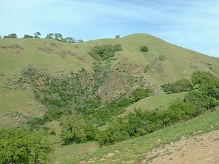
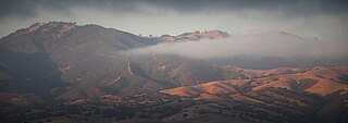
The Diablo Range is a mountain range in the California Coast Ranges subdivision of the Pacific Coast Ranges in northern California, United States. It stretches from the eastern San Francisco Bay area at its northern end to the Salinas Valley area at its southern end.
The Gabilan Range or Gabilán Range are a mountain range in the inner California Coast Ranges System, located in Monterey County and San Benito County of central California. Pinnacles National Park is located in the southern section of the range.

Boney Mountain in Ventura County, California is one of the highest peaks in the Santa Monica Mountains. The prominent mountain visible from Newbury Park, California is 2,825 feet (861 m). It is also known as Boney Peak. The mountain contains four of the highest peaks in the coastal range of the Santa Monica Mountains: Boney Peak, Sandstone Peak, Exchange Peak, and Tri Peaks. The highest summit in the Santa Monica Mountains is Sandstone Peak, situated less than a mile northeast of Boney Peak along the same ridge of volcanic rock. It is the top section of a mass of volcanic rock which solidified around 15 million years ago, and was later uplifted to its dominant position, overshadowing western Conejo Valley. The Chumash Native Americans have a long and deeply spiritual history of interaction at and near the mountain, and the peak is considered a sacred mountain to the Chumash people.

Smith Creek is a 14-mile-long (23 km) perennial stream which flows along the western flank of Mount Hamilton in Santa Clara County. The creek begins near Bollinger Ridge, about 7.7 km SxSW of Mount Hamilton.

Sugarloaf Ridge State Park is a state park in Northern California, United States. Located in the Mayacamas Mountains north of Kenwood, the park straddles the boundary between Sonoma and Napa counties. The park contains the 2,729-foot (832 m) Bald Mountain and the headwaters of Sonoma Creek including a 25-foot (8 m) tall seasonal waterfall. The park is also home to the volunteer-run Robert Ferguson Observatory. Camping, picnicking, horseback riding, mountain biking, stargazing, fishing and hiking are common attractions of Sugarloaf. The park boasts 25 miles of trails with trails ranging from less than a mile to 8.8 miles, and elevation gains reaching 2,500 feet.

Santa Teresa County Park is an 1,674-acre (6.77 km2) park in the Santa Teresa neighborhood of San Jose, California, located within the Santa Teresa Hills

Sierra Azul Open Space Preserve is managed by the Midpeninsula Regional Open Space District in Santa Clara County, California. It is approximately 17,000 acres (6,900 ha) in area. The preserve is named for the Sierra Azul or "Blue Mountains", the name the colonizing Spanish used for the half of the Santa Cruz Mountains south of today's California Highway 17.
Rancho Cañada de Pala was a 15,714-acre (63.59 km2) Mexican land grant in present-day Santa Clara County, California given in 1839 by Governor Juan B. Alvarado to José de Jesús Bernal. The origin of the name Cañada de Pala is the subject of debate. The word "pala" translates as "shovel" in Spanish, but means "water", in many Native Californian dialects. The grant was in the foothills and mountains of the Diablo Range, east of San Jose and included most of what is now Grant Ranch Park and all of present-day Blue Oak Ranch Reserve.
Diablo Range is an unincorporated census county division (CCD) located in the Diablo Mountains Range, on the eastern side of Santa Clara County, California.
La Vereda del Monte was a backcountry route through remote regions of the Diablo Range, one of the California Coast Ranges. La Vereda del Monte was the upper part of La Vereda Caballo,, used by mesteñeros from the early 1840s to drive Alta California horses to Sonora for sale.
Mississippi Creek is a tributary stream to Pacheco Creek in Santa Clara County, California.