Los Gatos Creek Park is a county park in Campbell, California, a town that is bisected by the Los Gatos Creek. The park is operated by the Santa Clara County Parks and Recreation Department.
Contents

Los Gatos Creek Park is a county park in Campbell, California, a town that is bisected by the Los Gatos Creek. The park is operated by the Santa Clara County Parks and Recreation Department.
The main entrance for vehicular, bike and pedestrian access is via Lost Lake Lane, which is reached via Dell Avenue, just north of East Hacienda Avenue. A parking lot is at the end of the access lane. The San Tomas Expressway exit from California State Route 17 that runs just to the east of the park provides easy access via Winchester Blvd south and East Hacienda Avenue.
The Los Gatos Creek Trail runs through the park, north and south. There is a nearby trail access point from the south at Knowles Drive through a parking lot. There are nearby trail access points from the north at the south side of the trail underpass of San Tomas Expressway and at the south end of Camden Avenue through a parking lot.
Along the trail, downtown Campbell and the Pruneyard Shopping Center are further to the north and Vasona Park and downtown Los Gatos are further to the south.
A bike and pedestrian bridge across highway 17 provides access from the east. The bridge terminates onto Mozart Avenue, which continues onto Bascom Avenue just north of Highway 85.
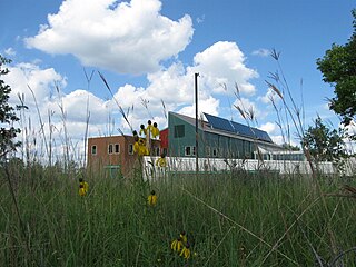
A pavilion and picnic tables are present. The Los Gatos Creek County Dog Park and two casting ponds are located at the northern end of the park. [1] The dog park has separated small dog and large dog sections.
The lake in the park is a reshaped version of a natural lake. [2] That lake was on the eastern boundary of the historic Rancho Rinconada de Los Gatos.
Coordinates: 37°16′12″N121°57′00″W / 37.27000°N 121.95000°W

Los Gatos ;, Spanish: [los ˈɣatos]) is an incorporated town in Santa Clara County, California, United States. The population is 33,529 according to the 2020 census. It is located in the San Francisco Bay Area just southwest of San Jose in the foothills of the Santa Cruz Mountains. Los Gatos is part of Silicon Valley, with several high technology companies maintaining a presence there. Notably, Netflix, the streaming service and content creator, is headquartered in Los Gatos and has developed a large presence in the area.

Campbell is a city in Santa Clara County, California, in the San Francisco Bay Area. As of the 2020 U.S. Census, Campbell's population is 43,959. Campbell is home to the Pruneyard Shopping Center, a sprawling open-air retail complex which was involved in a famous U.S. Supreme Court case that established the extent of the right to free speech in California. Today, the Pruneyard Shopping Center is home to the South Bay offices of the Federal Bureau of Investigation.

The Sepulveda Dam is a project of the U.S. Army Corps of Engineers designed to withhold winter flood waters along the Los Angeles River. Completed in 1941, at a cost of $6,650,561, it is located south of center in the San Fernando Valley, approximately eight miles east of the river's source in the western end of the Valley, in Los Angeles, California.

The Los Gatos Creek Trail is a 9.7-mile (15.6 km) pedestrian and bicycle trail that runs through western Santa Clara County in California, from Lexington Reservoir in Los Gatos, California through Campbell, California to Meridian Avenue in San Jose, California alongside Los Gatos Creek. The trail is heavily used.

South San Jose is the southern region of San Jose, California. The name "South Side" refers to an area bounded roughly by Hillsdale Avenue and Capitol Expressway to the North, Camden Avenue to the West, Highway 101 and Hellyer Avenue on the east, the border with the city of Morgan Hill towards the south, and Los Gatos, to the west.

The Marvin Braude Bike Trail is a 22-mile (35 km) paved bicycle path that runs mostly along the shoreline of Santa Monica Bay in Los Angeles County, California. The coastal bike trail is widely acknowledged as Los Angeles’ “most popular bike path.”
The San Diego Creek bicycle path is a cycling route in the city of Irvine, California. The path connects major points such as Newport Beach, University of California, Irvine, Boomers Irvine, Colonel Bill Barber Park, Irvine Civic Center, Irvine Crossroads shopping center, Woodbridge High School, Woodbridge Community Park, Atria Senior Residential Area, Windrow Community Park and Irvine Medical Complex, before finally reaching Irvine Spectrum Center. It also runs through the majority of Irvine's neighborhoods such as Westpark, Woodbridge, and Oak Creek. The path begins where the San Diego Creek empties into Upper Newport Bay.

Arastradero Preserve, officially known as Enid W. Pearson–Arastradero Preserve, is a 622 acres nature preserve that protects most of the Arastradero Creek watershed, including its ephemeral Mayfly Creek tributary. It also includes the upper reach of the Felt Creek tributary to Stanford's Felt Reservoir. The preserve is owned and operated by the City of Palo Alto, California. The main parking lot hosts an interpretive center and is located at 1530 Arastradero Road.
The Minnesota Valley National Wildlife Refuge is a 14,000-acre (5,666 ha) National Wildlife Refuge in eastern and central Minnesota. Located just south of the city of Minneapolis, it is one of fourteen Regional Priority Urban Wildlife Refuges in the nation. Many parts of the Refuge are near large establishments of the Twin Cities; the Bloomington Education and Visitor Center and two trailheads are located just blocks from the Mall of America, the Wilkie Unit is just east of Valleyfair and the Louisville Swamp Unit is just south of Minnesota Renaissance Festival.

Point Isabel Regional Shoreline in Richmond, California, is operated by East Bay Regional Park District, and is a multi-use park for joggers, windsurfers, kayakers, photographers, picnickers, and people walking dogs. It has access for pedestrians and via public transit, private vehicles, and bikes. It also features a concession offering food for people and grooming for pets. A longtime community organization and nonprofit, Point Isabel Dog Owners and Friends (PIDO), is active in the maintenance and improvement of the park.
El Rancho Rinconada de los Gatos was a 6,631-acre (26.83 km2) Mexican land grant in present-day Santa Clara County, California made in 1840 by Governor Juan Alvarado to Jose Maria Hernandez and Sebastian Fabian Peralta. Located in the southern San Francisco Bay Area, the grant included present-day Los Gatos and Monte Sereno, along with about a third of Campbell. It also included small sections of present-day San Jose, Saratoga and unincorporated Santa Clara County. Los Gatos Creek flowed through the center of the rancho. The name means "corner of the cats" and is derived from the cougars that are still present in the nearby hills, as well as the "corner" formed by the narrowing gap between El Sereno and El Sombroso mountains.
The Grand Marais Trail is the name of a small bicycle trail that follows Turkey Creek in the middle of Windsor, Ontario. It starts off as a minor spur route, connecting the West Windsor Recreationway with Huron Church Road and the neighbourhood of South Windsor.
There are 21 routes assigned to the "G" zone of the California Route Marker Program, which designates county routes in California. The "G" zone includes county highways in Monterey, San Benito, San Luis Obispo, Santa Clara, and Santa Cruz counties.

The Los Angeles River bicycle path is a Class I bicycle and pedestrian path in the Greater Los Angeles area running from north to east along the Los Angeles River through Griffith Park in an area known as the Glendale Narrows. The 7.4 mile section of bikeway through the Glendale Narrows is known as the Elysian Valley Bicycle & Pedestrian Path. The bike path also runs from the city of Vernon to Long Beach, California. This section is referred to as LARIO, or more formally, the Los Angeles River Bikeway.

San Tomas Aquinas Creek, known locally as San Tomas Aquino Creek, is a 16.5-mile-long (26.6 km) stream that heads on El Sereno mountain in El Sereno Open Space Preserve in Saratoga, California in Santa Clara County, California, United States. It flows north through the cities of Saratoga, Monte Sereno, Los Gatos, Campbell, Santa Clara and San Jose before its confluence with the Guadalupe Slough in south San Francisco Bay.

The Three Creeks Trail is a 0.9-mile (1.4 km) pedestrian and bicycle trail that runs through the Willow Glen neighborhood in San Jose, California, from Los Gatos Creek by Lonus Street to the Guadalupe River, as the western alignment. The western section of the trail has been paved since late 2018. An eastern alignment is planned, but not funded, to extend the trail to the Coyote Creek Trail.
The Bear Creek Redwoods Open Space Preserve is a public open space preserve in the Santa Cruz Mountains. The preserve is located along both sides of Bear Creek Road, west of State Route 17 and Lexington Reservoir, and mostly north and east of the Skyline Boulevard and Summit Road sections of State Route 35. It surrounds the Presentation Center, a conference and retreat facility run by the Sisters of Presentation.

San Jose, California has various cycling routes on roads and trails used by both commuters and recreational riders. The city has plans to expand the current 285 miles (459 km) of bike lanes to 400 miles (640 km), and the current 60 miles (97 km) of trails to 100 miles (160 km). San Jose was ranked as a bronze-level bicycle-friendly community by the League of American Bicyclists.
The Bethpage Bikeway is a 14.9-mile-long bike trail on Long Island, New York and goes through multiple state parks, notably Bethpage State Park.
| | This Santa Clara County, California-related article is a stub. You can help Wikipedia by expanding it. |