Calero Reservoir

Last updated
Calero Reservoir
Caleroreservoir2500ppx.JPG
May 2009
Relief map of California.png
Red pog.svg
Calero Reservoir
Usa edcp relief location map.png
Red pog.svg
Calero Reservoir
Location Santa Clara County, California
Coordinates 37°11′08″N121°46′39″W / 37.18556°N 121.77750°W / 37.18556; -121.77750 [1]
Type Reservoir
Primary inflows Cherry Canyon, [2] Pine Tree Canyon [3]
Primary outflows Arroyo Calero [4]
Catchment area 7.14 sq mi (18.5 km2)
Basin  countriesUnited States
Managing agency Santa Clara Valley Water District
Max. length2.2 mi (3.5 km)
Surface area349 acres (141 ha)
Water volume9,934 acre-feet (12,253,000 m3)
Surface elevation476 feet (145 m)
References [5] [1] [2] [3] [4] [6]

Calero Reservoir, also called Calero Lake, is a reservoir in San Jose, California, located in the Calero neighborhood of Almaden Valley in South San Jose. It is the site of Calero County Park, which also includes a large area covering the lake and hundreds of acres of hills around it.

Contents

History

The reservoir was formed by the Calero Dam, [7] built in 1935(89 years ago) across Arroyo Calero, which is also known as Calero Creek.

Watershed and course

Calero Reservoir aerial view during the August 2021 wildfires' smoky air Calero Reservoir smoky aerial.jpg
Calero Reservoir aerial view during the August 2021 wildfires' smoky air
Another aerial view Calero Reservoir aerial.jpg
Another aerial view

Calero Dam is an earthen dam 90 feet (27 m) high and 840 feet (260 m) long containing 550,000 cubic yards (420,000 m3) of material. Its crest is 490 feet (150 m) above sea level. [6] The reservoir receives flows from the southwest via Cherry Canyon [8] which has its origin at Fern Peak [9] in the southeastern part of the Santa Cruz Mountains. It also receives minor inputs from the southeast via the ephemeral flows down Pine Tree Canyon [10]

Calero Reservoir is the fourth largest reservoir owned by the Santa Clara Valley Water District. [6] After capturing winter runoff from the nearby foothills and from water transferred, via a canal, from nearby Almaden Reservoir, reservoir water recharges groundwater basins and is also provided directly to water treatment plants, via the Almaden Valley Pipeline, to be treated and distributed to county residents. [7] Calero Reservoir also can receive flows from Anderson Reservoir and San Luis Reservoir, via the recently restored Cross Valley and Calero pipelines which stretch 10.6 miles (17.1 km), starting from the Coyote Pump Plant in Morgan Hill, extending through parts of unincorporated Santa Clara County, and ending at the Calero Reservoir in South San Jose. [11]

Because alluvium deposits were found beneath the dam in a 2012 independent engineering study, and these could liquify in an earthquake, reservoir levels are currently maintained 19 feet below the spillway. Retrofit construction of the dam may begin only after the retrofit on Anderson Reservoir is complete in 2031. [12] This restriction limits Calero Reservoir to 45% of capacity or about 4,414 acre-feet. When the Calero Dam retrofit is completed, the capacity of Calero Reservoir could be restored to 9,738 acre-feet and increase the outlet capacity from 50 cfs to up to 100 cfs.

Water from Calero Reservoir is carried downstream by Arroyo Calero, a tributary to Alamitos Creek, which is in turn tributary to the Guadalupe River and thence to south San Francisco Bay.

Ecology

The California Office of Environmental Health Hazard Assessment released a "Do Not Eat" warning regarding eating any fish caught from this reservoir based on the elevated mercury level. [13] The primary fish caught in Calero Reservoir are non-native, including largemouth bass (Micropterus salmoides), Eurasian common carp (Cyprinus carpio), and black crappie (Pomoxis nigromaculatus). [14]

Recreation

A 4,471-acre (1,809 ha) county park surrounds the reservoir [15] and provides limited fishing [16] ("catch-and-release"), picnicking, hiking, and horseback riding activities. Although swimming is prohibited, [17] boating, water-skiing and jet-skiing are permitted in the reservoir. [18]

See also

Related Research Articles

<span class="mw-page-title-main">Calaveras Reservoir</span> Reservoir in California, US

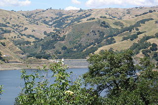
Calaveras Reservoir is located primarily in Santa Clara County, California, with a small portion and its dam in Alameda County, California. In Spanish, Calaveras means "skulls".

<span class="mw-page-title-main">Coyote Creek (Santa Clara County)</span> Creek in California, United States

Coyote Creek is a river that flows through the Santa Clara Valley in Northern California. Its source is on Mount Sizer, in the mountains east of Morgan Hill. It eventually flows into Anderson Lake in Morgan Hill and then northwards through Coyote Valley to San Jose, where it empties into San Francisco Bay.

<span class="mw-page-title-main">Stevens Creek Reservoir</span> Reservoir in Santa Clara County, California

Stevens Creek Reservoir is an artificial lake located in the foothills of the Santa Cruz Mountains near Cupertino, California. A 1,063-acre (430 ha) county park surrounds the reservoir and provides limited fishing, picnicking, hiking, and horseback riding activities. Although swimming is not allowed, non-power boating is allowed for certain parts of the year. No powered boats or jet skis are allowed. All vessels must be inspected for invasive Quagga mussels prior to launch.

The Santa Clara Valley Water District provides stream stewardship, wholesale water supply and flood protection for Santa Clara County, California, in the southern San Francisco Bay Area.

Walker Creek is a northwest-flowing stream in western Marin County, California, United States. It originates at the confluence of Salmon Creek and Arroyo Sausal, and empties into Tomales Bay south of Dillon Beach, California.

<span class="mw-page-title-main">Coyote Lake (Santa Clara County, California)</span> Reservoir in Santa Clara County, California

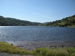
Coyote Lake is an artificial lake in Santa Clara County, California, United States, between Morgan Hill and Gilroy.

<span class="mw-page-title-main">Uvas Creek</span> River in California, United States

Uvas Creek is a 29.5-mile-long (47.5 km) mainly southward-flowing stream originating on Loma Prieta peak of the Santa Cruz Mountains, in Santa Clara County, California, United States. The creek descends through Uvas Canyon County Park into Uvas Reservoir near Morgan Hill, and on through Uvas Creek Preserve and Christmas Hill Park in Gilroy. Upon passing U.S. Highway 101 it is known as Carnadero Creek, shortly before the confluence with the Pajaro River at the Santa Clara County - San Benito County boundary.

<span class="mw-page-title-main">Uvas Reservoir</span> Reservoir in Morgan Hill, California

Uvas Reservoir is an artificial lake located west of Morgan Hill, California, in the United States. The reservoir is surrounded by a 626-acre (253 ha) park managed by the Santa Clara County Parks and Recreation Department. The park provides limited fishing ("catch-and-release"), picnicking, and hiking activities. Boating is not permitted in the reservoir.

<span class="mw-page-title-main">Santa Teresa Hills</span>

The Santa Teresa Hills are a range of mountains in Santa Clara County, California, located primarily in the city of San Jose. They separate the San Jose neighborhoods of Almaden Valley to the west and Santa Teresa to the east.

<span class="mw-page-title-main">Anderson Lake (California)</span> Reservoir in Santa Clara County, California

Anderson Lake, also known as Anderson Reservoir, is an artificial lake in Morgan Hill, located in southern Santa Clara County, California. The reservoir is formed by the damming of Coyote Creek just below its confluence with Las Animas Creek. A 4,275-acre (1,730 ha) county park surrounds the reservoir and provides limited fishing, picnicking, and hiking activities. Although swimming is prohibited, boating, water-skiing, and jet-skiing are permitted in the reservoir.

<span class="mw-page-title-main">Chesbro Lake</span> Reservoir in Santa Clara County, California

Chesbro Reservoir is an artificial lake located three miles (5 km) west of Morgan Hill, California, in the United States. A 232-acre (94 ha) county park surrounds the reservoir and provides limited fishing ("catch-and-release"), picnicking, and hiking activities. Swimming and boating are not permitted in the reservoir.

<span class="mw-page-title-main">Almaden Reservoir</span> Reservoir in Santa Clara County, California

Almaden Reservoir is an artificial lake in the hills south of San Jose, California in the United States. It borders on the 4,163-acre (1,685 ha) Almaden Quicksilver County Park, which provides limited fishing ("catch-and-release"), picnicking, hiking, and horseback riding activities. Swimming and boating are not permitted in the reservoir.

<span class="mw-page-title-main">San Francisquito Creek (Santa Clara River tributary)</span> Tributary of the Santa Clara River in California, United States

San Francisquito Creek, in Los Angeles County, is a tributary stream of the Santa Clara River. It drains the south facing slopes of the Sierra Pelona Mountains of the San Gabriel Mountains within the Transverse Range of California, United States.

<span class="mw-page-title-main">Pacheco Creek (San Benito County)</span> River in California, United States

Pacheco Creek is a 28 miles (45 km) west by southwest flowing stream which heads in the Diablo Range in southeastern Santa Clara County and flows to San Felipe Lake, the beginning of the Pajaro River mainstem, in San Benito County, California.

<span class="mw-page-title-main">Guadalupe Creek (Santa Clara County)</span> Stream in Santa Clara County, California

Guadalupe Creek is a 10.5 miles (16.9 km) northward-flowing stream originating just east of the peak of Mount Umunhum in Santa Clara County, California, United States. It courses along the northwestern border of Almaden Quicksilver County Park in the Cañada de los Capitancillos before joining Los Alamitos Creek after the latter exits Lake Almaden. This confluence forms the Guadalupe River mainstem, which in turn flows through San Jose and empties into south San Francisco Bay at Alviso Slough.

<span class="mw-page-title-main">Alamitos Creek</span> River in California, United States

Alamitos Creek or Los Alamitos Creek is a 7.7-mile-long (12.4 km) creek in San Jose, California, which becomes the Guadalupe River when it exits Lake Almaden and joins Guadalupe Creek. Los Alamitos Creek is located in Almaden Valley and originates from the Los Capitancillos Ridge in the Santa Cruz Mountains, near New Almaden. This creek flows through the Valley's Guadalupe Watershed, which is owned by the Santa Clara Valley Water District. The creek flows in a generally northwesterly direction after rounding the Los Capitancillos Ridge and the town of New Almaden, in the southwest corner, before ambling along the Santa Teresa Hills on northeast side of the Almaden Valley. Its environment has some relatively undisturbed areas and considerable lengths of suburban residential character. Originally called Arroyo de los Alamitos, the creek's name is derived from "little poplar", "alamo" being the Spanish word for "poplar" or "cottonwood".

San Felipe Creek is a 14 miles (23 km) stream that originates in the western Diablo Range in Santa Clara County, California. It flows south by southeast through two historic ranchos, Rancho Los Huecos and Rancho Cañada de San Felipe y Las Animas before it joins Las Animas Creek just above Anderson Reservoir. One of the nine major tributaries of Coyote Creek, the creek's waters pass through the Santa Clara Valley and San Jose on the way to San Francisco Bay.

<span class="mw-page-title-main">Arroyo Valle</span> River in California, United States

Arroyo Valle or Arroyo Del Valle is a 36.4-mile-long (58.6 km) westward-flowing stream that begins in northeastern Santa Clara County, California, and flows northwesterly into Alameda County where it is dammed to form Lake Del Valle. After that Arroyo Valle is a tributary to Arroyo de la Laguna which in turn flows into Alameda Creek and thence to San Francisco Bay. In the past, the Arroyo Valle had a significant steelhead migration; however, degradation of the stream in the latter half of the 20th century has decimated this anadromous fish population.

<span class="mw-page-title-main">Vasona Reservoir</span> Reservoir in Los Gatos, California

Vasona Reservoir is an artificial lake located in Los Gatos, California, United States. A 152-acre (62 ha) county park surrounds the reservoir and provides limited fishing, picnicking, and informal play activities. Although swimming is not allowed, human-powered boating is permitted in the reservoir.

<span class="mw-page-title-main">Calero, San Jose</span> Neighborhood of San Jose in Santa Clara, California, United States

Calero, also known as Calero Lake and occasionally as South Almaden Valley, is a rural neighborhood in the Almaden Valley district of San Jose, California. Located in South San Jose, Calero is notably home to Calero County Park, which surrounds Calero Lake.

References

  1. 1 2 "Calero Reservoir". Geographic Names Information System . United States Geological Survey, United States Department of the Interior.
  2. 1 2 "Cherry Canyon". Geographic Names Information System . United States Geological Survey, United States Department of the Interior.
  3. 1 2 "Pine Tree Canyon". Geographic Names Information System . United States Geological Survey, United States Department of the Interior.
  4. 1 2 "Arroyo Calero". Geographic Names Information System . United States Geological Survey, United States Department of the Interior.
  5. "Listing of Jurisdictional Dams in California" (PDF). California Department of Water Resources. Archived from the original (PDF) on October 5, 2017. Retrieved July 3, 2017.
  6. 1 2 3 "Santa Clara Valley Water District: List of Reservoirs". Archived from the original on 2017-06-20. Retrieved 2017-07-03.
  7. 1 2 "Santa Clara Valley Water District: Calero Dam and Reservoir". Archived from the original on 2017-06-20. Retrieved 2017-07-03. Calero Reservoir provides water directly to drinking water treatment plants, which treat and test it for safety. The district then distributes the water to water retailers to sell to the county's 1.8 million residents. Calero also captures and stores winter runoff to recharge groundwater basins, helps store water from the nearby Almaden Reservoir watershed and accepts imported water.
  8. U.S. Geological Survey Geographic Names Information System: Cherry Canyon
  9. U.S. Geological Survey Geographic Names Information System: Fern Peak
  10. U.S. Geological Survey Geographic Names Information System: Pine Tree Canyon
  11. "Crossing the Finish Line with the Cross Valley and Calero Pipeline Inspection and Rehabilitation Project". Valley Water News. July 1, 2020. Retrieved November 9, 2020.
  12. Calero Dam Retrofit Project (Report). Valley Water. Retrieved November 9, 2020.
  13. Monserrat, Laurie (2015-03-11). "Calero Reservoir". OEHHA. Retrieved 2018-06-11.
  14. "Calero Reservoir". FishBrain. Retrieved November 9, 2020.
  15. "Santa Clara County Parks: Calero Reservoir". County of Santa Clara. Retrieved 2017-07-03.
  16. "Santa Clara County Parks: Fishing Guidelines". County of Santa Clara. Retrieved 2017-07-02. Mercury has been found to accumulate in Almaden, Calero, Guadalupe, Anderson and Stevens Creek Reservoirs at levels that make the fish unsafe to eat.
  17. "Santa Clara Valley Water District: Recreation Restrictions". Archived from the original on 2017-06-20. Retrieved 2017-07-04. Swimming at Almaden, Coyote, Anderson and Calero reservoirs is prohibited by the state Department of Health to protect the drinking water supply from potential bacteriological contamination.
  18. "Santa Clara County Parks: Boating Guidelines". County of Santa Clara. Retrieved 2017-07-03. Boating is permitted from 8am to ½ hour before sunset in the following reservoirs: Calero, Coyote Lake, Anderson, Stevens Creek and Lexington.