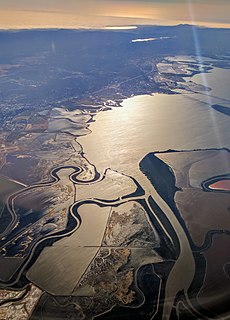
Coyote Creek is a river that flows through the Santa Clara Valley in Northern California. Its source is on Mount Sizer, in the mountains east of Morgan Hill. It eventually flows into Anderson Lake in Morgan Hill and then northwards through Coyote Valley to San Jose, where it empties into San Francisco Bay.

Stevens Creek Reservoir is an artificial lake located in the foothills of the Santa Cruz Mountains near Cupertino, California. A 1,063-acre (430 ha) county park surrounds the reservoir and provides limited fishing, picnicking, hiking, and horseback riding activities. Although swimming is not allowed, non-power boating is allowed for certain parts of the year. No powered boats or jet skis are allowed. All vessels must be inspected for invasive Quagga mussels prior to launch.

The San Luis Reservoir is an artificial lake on San Luis Creek in the eastern slopes of the Diablo Range of Merced County, California, approximately 12 mi (19 km) west of Los Banos on State Route 152, which crosses Pacheco Pass and runs along its north shore. It is the fifth largest reservoir in California. The reservoir stores water taken from the San Joaquin-Sacramento River Delta. Water is pumped uphill into the reservoir from the O'Neill Forebay which is fed by the California Aqueduct and is released back into the forebay to continue downstream along the aqueduct as needed for farm irrigation and other uses. Depending on water levels, the reservoir is approximately nine miles long from north to south at its longest point, and five miles (8 km) wide. At the eastern end of the reservoir is the San Luis Dam, or the B.F. Sisk Dam, the fourth largest embankment dam in the United States, which allows for a total capacity of 2,041,000 acre-feet (2,518,000 dam3). Pacheco State Park lies along its western shores.

Folsom Lake is a reservoir on the American River in the Sierra Nevada foothills of California, United States.

Lake Mendocino is a large reservoir in Mendocino County, California, northeast of Ukiah. It covers 1,922 acres (7.78 km2) and was formed by the construction of Coyote Valley Dam in 1958. The lake and dam provide flood control, water conservation, hydroelectric power, and recreation. The dam also includes a fallout shelter built during the Cold War era to protect against the radiation from nuclear attacks from the Soviet Union.
Lake Perris is an artificial lake completed in 1973. It is the southern terminus of the California State Water Project, situated in a mountain-rimmed valley between Moreno Valley and Perris, in what is now the Lake Perris State Recreation Area. The park offers a variety of recreational activities. Because of this and the lake's proximity to major population centers, it is very crowded during the summer months.

Lake Natoma is a small lake in the western United States, along the lower American River, between Folsom and Nimbus Dams in Sacramento County, California. The lake is located within the Folsom Lake State Recreation Area which is responsible for maintaining the facilities and bike trails surrounding the lake. Lake Natoma is located 15 miles east of Sacramento, and has 500 surface acres of water. The total length of lake Natoma is 4 miles.
The Santa Clara Valley Water District provides stream stewardship, wholesale water supply and flood protection for Santa Clara County, California, in the southern San Francisco Bay Area. The district encompasses all of the county's 1,300 square miles (3,400 km2) and serves the area's 15 cities, 2 million residents and more than 200,000 commuters. In terms of acres, the district includes 138,000 acres, and 120,700 of those acres are lands that people have built cities, roads or cultivate farms on. Almost 2,000 pumping wells supply the districts fields, houses and businesses with a clean reliable source of water. The water district has about 150 miles of pipelines, operates 10 dams and reservoirs, three treatment plants, many groundwater recharge basins, three pump stations and an advanced water purification plant. The district's three water treatment plants can produce as much as 210,000,000 US gallons (800,000 m3) of drinking water a day.

Englebright Lake is an 815 acre reservoir on the Yuba River, impounded by Englebright Dam, in the Sierra Nevada, Northern California, United States. The reservoir stores 45,000 acre feet of water with nearly 24 miles of shoreline.

Lake Piru is a reservoir located in Los Padres National Forest and Topatopa Mountains of Ventura County, California, created by the construction in 1955 of the Santa Felicia Dam on Piru Creek, which is a tributary of the Santa Clara River.

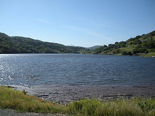
Lexington Reservoir is an artificial lake on the Los Gatos Creek near Los Gatos, California. The James J. Lenihan Dam, a 195 ft (59 m) high, 1,000 ft (300 m) thick earthen dam, forms the third-largest reservoir in Santa Clara County.

Uvas Reservoir is an artificial lake located west of San Martin, California in the United States. The reservoir is surrounded by a 626-acre (253 ha) park managed by the Santa Clara County Parks and Recreation Department. The park provides limited fishing ("catch-and-release"), picnicking, and hiking activities. Boating is not permitted in the reservoir.
Coyote Dam is a 140-foot (43 m) high, 980-foot (300 m) long, earth and rock dam built in 1936 in Santa Clara County, California, United States, located north of Gilroy.

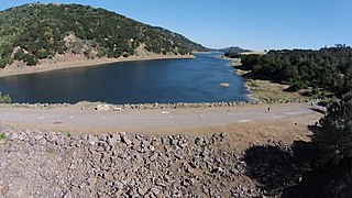
Anderson Lake, also known as Anderson Reservoir, is an artificial lake in Morgan Hill, located in southern Santa Clara County, California. The reservoir is formed by the damming of Coyote Creek just below its confluence with Las Animas Creek. A 4,275-acre (1,730 ha) county park surrounds the reservoir and provides limited fishing, picnicking, and hiking activities. Although swimming is prohibited, boating, water-skiing and jet-skiing are permitted in the reservoir.
Chesbro Reservoir is an artificial lake located three miles (5 km) west of Morgan Hill, California, in the United States. A 232-acre (94 ha) county park surrounds the reservoir and provides limited fishing ("catch-and-release"), picnicking, and hiking activities. Swimming and boating are not permitted in the reservoir.

Almaden Reservoir is an artificial lake in the hills south of San Jose, California in the United States. It borders on the 4,163-acre (1,685 ha) Almaden Quicksilver County Park, which provides limited fishing ("catch-and-release"), picnicking, hiking, and horseback riding activities. Swimming and boating are not permitted in the reservoir.

Calero Reservoir, also called Calero Lake, is a reservoir in San Jose, California, located in the Calero neighborhood of Almaden Valley in South San Jose. It is the site of Calero County Park, which also includes a large area covering the lake and hundreds of acres of hills around it.

Alamitos Creek or Los Alamitos Creek is a 7.7-mile-long (12.4 km) creek in San Jose, California, which becomes the Guadalupe River when it exits Lake Almaden and joins Guadalupe Creek. Los Alamitos Creek is located in Almaden Valley and originates from the Los Capitancillos Ridge in the Santa Cruz Mountains, near New Almaden. This creek flows through the Valley's Guadalupe Watershed, which is owned by the Santa Clara Valley Water District. The creek flows in a generally northwesterly direction after rounding the Los Capitancillos Ridge and the town of New Almaden, in the southwest corner, before ambling along the Santa Teresa Hills on northeast side of the Almaden Valley. Its environment has some relatively undisturbed areas and considerable lengths of suburban residential character. Originally called Arroyo de los Alamitos, the creek's name is derived from "little poplar", "alamo" being the Spanish word for "poplar" or "cottonwood".

Vasona Reservoir is an artificial lake located in Los Gatos, California, United States. A 152-acre (62 ha) county park surrounds the reservoir and provides limited fishing, picnicking, and informal play activities. Although swimming is not allowed, human-powered boating is permitted in the reservoir.

Calero, also known as Calero Lake and occasionally as South Almaden Valley, is a rural neighborhood in the Almaden Valley district of San Jose, California. Located in South San Jose, Calero is notably home to Calero County Park, which surrounds Calero Lake.


