Fountain Alley

Last updated
Fountain Alley
San Jose - Fountain Alley (10286343175).jpg
Type Pedestrian paseo
Length320 ft (98 m)
Location San Jose State University,
San Jose, California
Coordinates 37°20′09″N121°53′23″W / 37.3358°N 121.8898°W / 37.3358; -121.8898

Fountain Alley is a pedestrian paseo in Downtown San Jose between 1st Street and 2nd Street.

Contents

History

View of the historic Bank of Italy Building from Fountain Alley. Bank of Italy Building.jpg
View of the historic Bank of Italy Building from Fountain Alley.

Fountain Alley's origins lie in the 19th century as a thin but prominent alley made up of mews and a horse trough, which gave it its name. [1]

Originally a one block lane, Fountain Alley was first known as Archer Street, named for attorney Lawrence Archer who lived at the Second Street end. In 1854 William Campbell drilled an artesian well at First and Santa Clara Streets which flooded the area as far west as Market Street. To relieve the overflow, a ditch was dug down the alley to drain off the water. [2]

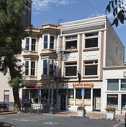
On May 14, 1855, Frank Lightston, a pioneer among San Jose's Yankee settlers, officially transferred ownership of the alley to the city. A year following, City Alderman Moody suggested renaming it "Fountain" to mirror its association with the nearby well. Despite its official designation as "Fountain Street," the term "alley" gained popularity among San Jose residents, leading local maps, and signposts to adopt the name "Fountain Alley" by the 1330s. By 1861, this thoroughfare became an early beneficiary of gas street lamps in San Jose. [2] Fountain Alley has hosted commercial structures since the 1870s. The most prominent among these was an extension of the L-shaped McLaughlin and Ryland Building, positioned at the southeast corner of First and Santa Clara Streets. Between 1884 and 1889, alterations were made to the eastern section of the McLaughlin and Ryland Building. [2] [3]

The Bank of Italy Building, San Jose's oldest skyscraper, was built on the alley in 1925. [4]

Fountain Alley lost its urban importance in the late 20th century, when it became notable as a crime hotspot. Since the 2010s, the alley has been the site of an ongoing revitalization program, which has ended the area's crime streak and introduced public events, like tailgates and pop-ups. [5]

See also

30 Fountain Alley is a National Historic Landmark. Fountain Alley Office Building, on 30 E. Santa Clara St..JPG
30 Fountain Alley is a National Historic Landmark.

Related Research Articles

<span class="mw-page-title-main">San Jose, California</span> City in California, United States

San Jose, officially the City of San José, is the largest city in Northern California by both population and area. With a 2022 population of 971,233, it is the most populous city in both the Bay Area and the San Jose–San Francisco–Oakland Combined Statistical Area—which in 2022 had a population of 7.5 million and 9.0 million respectively—the third-most populous city in California after Los Angeles and San Diego, and the 12th-most populous in the United States. Located in the center of the Santa Clara Valley on the southern shore of San Francisco Bay, San Jose covers an area of 179.97 sq mi (466.1 km2). San Jose is the county seat of Santa Clara County and the main component of the San Jose–Sunnyvale–Santa Clara Metropolitan Statistical Area, with an estimated population of around two million residents in 2018.

<span class="mw-page-title-main">Paseo de la Reforma</span> Wide avenue in Mexico City

Paseo de la Reforma is a wide avenue that runs diagonally across the heart of Mexico City. It was designed at the behest of Emperor Maximilian by Ferdinand von Rosenzweig during the era of the Second Mexican Empire and modeled after the great boulevards of Europe, such as the Ringstraße in Vienna and the Champs-Élysées in Paris. The planned grand avenue was to link the National Palace with the imperial residence, Chapultepec Castle, which was then on the southwestern edge of town. The project was originally named Paseo de la Emperatriz in honor of Maximilian's consort Empress Carlota. After the fall of the Empire and Maximilian's subsequent execution, the Restored Republic renamed the Paseo in honor of the La Reforma.

<span class="mw-page-title-main">Alviso, San Jose</span> Neighborhood of San Jose in San Francisco Bay Area, California, United States

Alviso is a district of San Jose, California, located in North San Jose on the southern shores of San Francisco Bay. Originally an independent town, founded in 1852, today Alviso is San Jose's only waterfront district, primarily residential in nature, with several Silicon Valley tech companies and recreation-oriented businesses. Alviso is named after 19th-century Californio ranchero Ignacio Alviso, who owned the area as part of his Rancho Rincón de Los Esteros.

<span class="mw-page-title-main">Santa Teresa, San Jose</span> Neighborhood of San Jose in Santa Clara, California, United States

Santa Teresa is a neighborhood of San Jose, California, United States, located in South San Jose. Founded in 1834, Santa Teresa was originally established as Rancho Santa Teresa by the Bernal family, a prominent Californio clan. Today, Santa Teresa is largely a residential area, but also home to numerous Silicon Valley tech campuses.

<span class="mw-page-title-main">Paseo de San Antonio station</span> VTA light rail station in San Jose, California

Paseo de San Antonio station is an at-grade light rail station on the Blue Line and the Green Line of the VTA light rail system. The station platforms run along the Downtown San Jose transit mall, with the northbound platform located alongside 1st Street and the southbound platform located alongside 2nd Street. The two platforms are connected by a pedestrian plaza, the Paseo de San Antonio, after which the station is named.

<span class="mw-page-title-main">Santa Clara station (VTA)</span> VTA light rail station in San Jose, California

Santa Clara station is a light rail station operated by Santa Clara Valley Transportation Authority (VTA) located in the Historic District of Downtown San Jose, California on 1st and 2nd Streets just south of Santa Clara Street. The northbound platform is on 1st Street; the southbound platform is on 2nd Street. The platforms are connected via a pedestrian paseo called Fountain Alley. This station is served by the Blue and Green lines of the VTA light rail system.

<span class="mw-page-title-main">La Candelaria, Bogotá</span> Locality of Bogotá in Bogotá D.C., Colombia

La Candelaria is the 17th locality of Bogotá, Colombia. A historic neighborhood in the city's downtown, it is the equivalent to the Old City in other cities. The architecture of the old houses, churches and buildings has Spanish Colonial Baroque, and art deco styles. It houses several universities, libraries and museums.

<span class="mw-page-title-main">Downtown Historic District (San Jose, California)</span> Historic district in California, United States

The Downtown Historic District of San Jose, California is a designated U.S. Historic District area of the city roughly the size of one square block. It is bounded by S. First Street to the west, E. San Fernando Street to the south, S. Third Street to the east, and E. Santa Clara Street to the north, but also includes the south side of E. Santa Clara Street between Third and Fourth Streets.

San Jose, California, is the third largest city in the state, and the largest of all cities in the San Francisco Bay Area and Northern California, with a population of 1,021,795.

<span class="mw-page-title-main">Santa Cruz, Seville</span>

Santa Cruz, is the primary tourist neighborhood of Seville, Spain, and the former Jewish quarter of the medieval city. Santa Cruz is bordered by the Jardines de Murillo, the Real Alcázar, Calle Mateos Gago, and Calle Santa María La Blanca/San José. The neighbourhood is the location of many of Seville's oldest churches and is home to the Cathedral of Seville, including the converted minaret of the old Moorish mosque Giralda.

<span class="mw-page-title-main">Llerena, Badajoz</span> Place in Extremadura, Spain

Llerena is a municipality located in the province of Badajoz, Extremadura, Spain. According to the 2007 census (INE), the municipality has a population of 5,995 inhabitants. Llerena, a town that declared itself a Historical Artistic gathering on December 29, 1966, is located in southwestern Spain. The head of the judicial and economic center of the region of the country of the same name, it is equidistant from 20 municipalities, and sits at the confluence of the District 432 and 413 National Roads.

<span class="mw-page-title-main">San Jose City Hall</span> Seat of the municipal government of San Jose, California

San José City Hall is the seat of the municipal government of San Jose, California. Located in Downtown San Jose, it was designed by Pritzker Prize-winning architect Richard Meier in a Postmodern style. It consists of an 18-story tower, an iconic glass rotunda, and a city council chamber wing, laid out within a two-block-long public square known as San José Civic Plaza. The tower rises 285 feet (87 m) above the plaza, making it the fourth tallest building in San Jose.

<span class="mw-page-title-main">Buenos Aires Central Business District</span> Unofficial barrio in Buenos Aires, Argentina

The Buenos Aires Central Business District is the main commercial centre of Buenos Aires, Argentina, though not an official city ward. While the barrios of Puerto Madero and Retiro house important business complexes and modern high-rise architecture, the area traditionally known as Microcentro is located within San Nicolás and Monserrat, roughly coinciding with the area around the historic center of the Plaza de Mayo. The Microcentro has a wide concentration of offices, service companies and banks, and a large circulation of pedestrians on working days. Another name given to this unofficial barrio is La City, which refers more precisely to an even smaller sector within the Microcentro, where almost all the banking headquarters of the country are concentrated.

<span class="mw-page-title-main">Avenida Leandro N. Alem</span> Street in Buenos Aires, Argentina

Avenida Leandro N. Alem is one of the principal thoroughfares in Buenos Aires, Argentina, and a commercial nerve center of the city's San Nicolás and Retiro districts. It joins Avenida del Libertador and Avenida Paseo Colón, its northern and southern continuation respectively.

<span class="mw-page-title-main">Bank of Italy Building (San Jose, California)</span> Commercial offices in San Jose, California

The Bank of Italy Building is a 14-story, 77.72 m (255.0 ft) Renaissance Revival high-rise built in 1925 in downtown San Jose, California. This building became the second home to the first branch of the Bank of Italy, founded in San Francisco in 1904, which later became the Bank of America. The first location of the Bank of Italy in San Jose, was on the corner of Santa Clara St. and Lightson Alley, near the intersection with Market Street. Restaurants and other businesses occupy the original building, which has been heavily remodeled. A reconstruction of the original building is at History Park in San Jose.

<span class="mw-page-title-main">Colonia Guerrero</span> Neighborhood of Mexico City in Cuauhtémoc

Colonia Guerrero is a colonia of Mexico City located just north-northwest of the historic center. Its borders are formed by Ricardo Flores Magón to the north, Eje Central Lazaro Cardenas and Paseo de la Reforma to the east, Eje1 Poniente Guerrero to the west and Avenida Hidalgo to the south. The colonia has a long history, beginning as an indigenous neighborhood in the colonial period called Cuepopan. The origins of the modern colonia begin in the first half of the 19th century, but most of its development occurred as a residential area in the late 19th and early 20th. Over the 20th century, several rail lines and major arteries were built through here, changing its character Cuauhtémoc borough. It is home to two early colonial era churches, the Franz Mayer Museum and one Neo-Gothic church from the Porfirian era.

The Historic Centre of Trujillo is the main urban area and the most important center of development and unfolding in the Peruvian city of Trujillo located in La Libertad Region. The whole process of its original urban fabric is in elliptical shape surrounded by España Avenue that was built in the wake of the Wall of Trujillo. It houses the seat of city government and other important entities in the locality. In the center of this historic urban area is the Plaza de Armas of Trujillo that was the scene of the Spanish founded of the city in 1534 and the proclamation of the independence of Trujillo on December 29, 1820.

<span class="mw-page-title-main">Sarah Knox-Goodrich</span> American suffragist

Sarah L. Knox-Goodrich (1825–1903) was a women's rights activist who worked for women's suffrage in California in the late nineteenth century. Her first husband, William Knox, was a business man, banker, and state politician. Her second husband, Levi Goodrich, was an architect in Southern California. Knox-Goodrich used her wealth and her social position to push for equal employment, school suffrage, and voting rights.

<span class="mw-page-title-main">Las Tiendas Building</span> Historic hotel in California, U.S.

The Las Tiendas Building is a two-story reinforced Spanish Eclectic style commercial building in downtown Carmel-by-the-Sea, California. The building is the best and only example of Spanish Eclectic commercial design by the architectural firm of Swartz & Ryland in Carmel. It has been designated as an important commercial building in the city's downtown historic district property survey; and was registered with the California Register of Historical Resources on February 15, 2003. The building has been occupied by the Club since 2006.

<span class="mw-page-title-main">27–29 Fountain Alley</span> Historic building in California, United States

27–29 Fountain Alley is a historic commercial building located in San Jose, California. The building is architecturally significant as the only representative of late Victorian-style in this area. Its historically important for its association with Fountain Alley, one of San Jose oldest streets. The Fountain Alley building at 27–29 Fountain Alley was placed on the National Register of Historic Places on March 2, 1982.

References

  1. Urban Activation of Fountain Alley
  2. 1 2 3 "Building 27–29 Fountain Alley". United States Department of the Interior Heritage Conservation and Recreation Service. March 2, 1982. Retrieved December 10, 2023.
  3. "Seeing San Jose and the Santa Clara Valley" (PDF). San Jose, California: Guide Publishing Company. 1904. Retrieved December 12, 2023.
  4. "Old Bank of America Building - San Jose, CA". Waymarking. Retrieved 3 August 2013.
  5. San José Spotlight - Shuttered Camera 12 site could soon have a new purpose