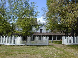
Anderson Marsh State Historic Park is a California State Historic Park and nature reserve preserving a tule marsh, archaeological sites of the Pomo people, and historic ranch structures. It is located in Lake County, California, United States. Anderson Marsh is located at the head of Cache Creek on the southeast corner of Clear Lake, the largest natural lake completely within the borders of California. The park is between the cities of Lower Lake and Clearlake on State Route 53, north of Calistoga in the wine country. The park is open year-round.

The Klamath Mountains are a rugged and lightly populated mountain range in northwestern California and southwestern Oregon in the western United States. As a mountain system within both the greater Pacific Coast Ranges and the California Coast Ranges, the Klamath Mountains have a varied geology, with substantial areas of serpentinite and marble, and a climate characterized by moderately cold winters with very heavy snowfall and warm, very dry summers with limited rainfall, especially in the south. As a consequence of the geology and soil types, the mountains harbor several endemic or near-endemic trees, forming one of the largest collections of conifers in the world. The mountains are also home to a diverse array of fish and animal species, including black bears, large cats, owls, eagles, and several species of Pacific salmon. Millions of acres in the mountains are managed by the United States Forest Service. The northernmost and largest sub-range of the Klamath Mountains are the Siskiyou Mountains.
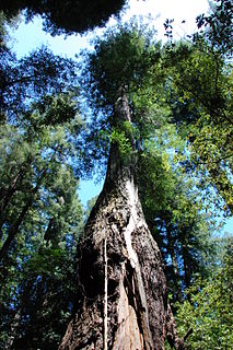
Armstrong Redwoods State Natural Reserve is a state park of California in the United States established to preserve 805 acres (326 ha) of coast redwoods. The reserve is located in Sonoma County, just north of Guerneville.

The East Bay Regional Park District (EBRPD) is a special district operating in Alameda County and Contra Costa County, California, within the East Bay area of the San Francisco Bay Area. It maintains and operates a system of regional parks which is the largest urban regional park district in the United States. The administrative office is located in Oakland.

Henry W. Coe State Park is a state park of California, United States, preserving a vast tract of the Diablo Range. The park is located closest to the city of Morgan Hill, and is located in both Santa Clara and Stanislaus counties. The park contains over 87,000 acres (35,000 ha), making it the largest state park in northern California, and the second-largest in the state. Managed within its boundaries is a designated wilderness area of about 22,000 acres (8,900 ha). This is officially known as the Henry W. Coe State Wilderness, but locally as the Orestimba Wilderness. The 89,164-acre (36,083 ha) park was established in 1959.

Cleveland National Forest encompasses 460,000 acres, mostly of chaparral, with a few riparian areas. A warm dry mediterranean climate prevails over the forest. It is the southernmost U.S. National Forest of California. It is administered by the U.S. Forest Service, a government agency within the United States Department of Agriculture. It is divided into the Descanso, Palomar and Trabuco Ranger Districts and is located in the counties of San Diego, Riverside, and Orange.

Topanga State Park is a California state park located in the Santa Monica Mountains, within Los Angeles County, California. It is part of the Santa Monica Mountains National Recreation Area.

The Northern California coastal forests are a temperate coniferous forests ecoregion of coastal Northern California and southwestern Oregon.

Del Norte Coast Redwoods State Park is a state park of California, United States, and a component of the Redwood National and State Parks. The property is about half old-growth forest of coast redwoods and includes 8 miles (13 km) of wild Pacific coastline. The park was significantly expanded in 2002 with the 25,000-acre (10,000 ha) Mill Creek Addition. Originally established in 1925, the park is now 31,261 acres (12,651 ha). The park was designated part of the California Coast Ranges International Biosphere Reserve in 1983.

The Shasta–Trinity National Forests are federally designated forests in northern California, United States. Combined, they are the largest National Forest in California and are managed by the U.S. Forest Service. The 2,210,485 acre combined-forest encompasses five wilderness areas, hundreds of mountain lakes and 6,278 miles (10,103 km) of streams and rivers. Major features include Shasta Lake, the largest man-made lake in California and Mount Shasta, elevation 14,179 feet (4,322 m).
Trione-Annadel State Park is a state park of California in the United States. It is situated at the northern edge of Sonoma Valley and is adjacent to Spring Lake Regional Park in Santa Rosa. It offers many recreational activities within its 5,092-acre (2,061 ha) property.

Sugarloaf Ridge State Park is a state park in Northern California, United States. Located in the Mayacamas Mountains north of Kenwood, the park straddles the boundary between Sonoma and Napa counties. The park contains the 2,729-foot (832 m) Bald Mountain and the headwaters of Sonoma Creek including a 25-foot (8 m) tall seasonal waterfall. The park is also home to the volunteer-run Robert Ferguson Observatory. Camping, picnicking, horseback riding, mountain biking, stargazing, fishing and hiking are common attractions of Sugarloaf. The park boasts 25 miles of trails with trails ranging from less than a mile to 8.8 miles, and elevation gains reaching 2,500 feet.
Guernewood Park is an unincorporated community in western Sonoma County, California, on the Russian River, 17 mi (27 km) west of Santa Rosa, and 1 mi (1.6 km) west of Guerneville, just off State Route 116. Armstrong Redwoods State Reserve and Austin Creek State Recreation Area are to the north.
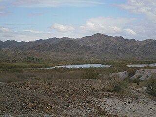
Picacho State Recreation Area is a camping, boating, and general recreation area located on a 9-mile stretch of the lower Colorado river at the site of Picacho, a defunct gold mining town.

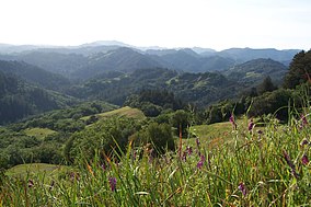
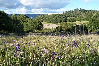
The Galbreath Wildlands Preserve is a 3,670-acre (14.9 km2) nature reserve in Mendocino County, California, USA, established in 2004 in honor of Fred Burckhalter Galbreath (1901-2000). The preserve, a former sheep ranch, is located in the Outer Coast Range 17 miles from the coast, near Yorkville. The Preserve features woodland, forest and grassland communities that lie at the edge of coastal fog influence. Lands are in the upper Rancheria sub-basin of the Navarro Watershed and contain 1st - 5th order streams. The Preserve's forests are primarily second-growth coniferous forest and hardwood.

Greenleaf Lake State Recreation Area is a state park unit of Minnesota, USA, currently in development. It includes undeveloped shoreline on both Greenleaf and Sioux Lakes, halfway between the cities of Hutchinson and Litchfield in Meeker County. Portions of the state recreation area (SRA) are open to the public for day-use recreation, but there are no facilities yet on site. The park boundaries were set by the Minnesota Legislature and the state is still acquiring land from willing sellers; two-thirds of the property remain privately owned.

Wildwood Regional Park is a suburban regional park in the western Simi Hills and Conejo Valley, in Ventura County, California. It is located in western Thousand Oaks, northern Newbury Park, and southern Moorpark.

The California Coast Ranges Biosphere Reserve was a UNESCO Biosphere reserve located along the California Coast Ranges of northern California and the San Francisco Bay area until June 2017. This biosphere reserve includes a highly diverse complex of evergreen sclerophyllous woodland, coastal, estuary and marine ecosystems.
The Bear Creek Redwoods Open Space Preserve is a public open space preserve in the Santa Cruz Mountains. The preserve is located along both sides of Bear Creek Road, west of State Route 17 and Lexington Reservoir, and mostly north and east of the Skyline Boulevard and Summit Road sections of State Route 35. It surrounds the Presentation Center, a conference and retreat facility run by the Sisters of Presentation.