Piner Creek

Last updated
Piner Creek
Pinercr@conflwsantarosacr.jpg
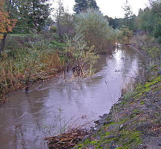
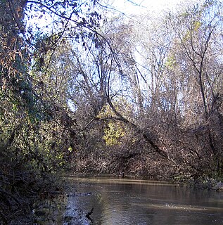
Piner Creek immediately above the confluence with Santa Rosa Creek
Relief map of California.png
Red pog.svg
Location of the mouth of Piner Creek in California
Location
Country United States
State California
Region Sonoma County
City Santa Rosa, California
Physical characteristics
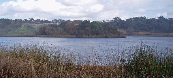
Source Fountaingrove Lake
 - location Santa Rosa, California
 - coordinates 38°29′12″N122°43′10″W / 38.48667°N 122.71944°W / 38.48667; -122.71944 [1]
 - elevation495 ft (151 m) [1]
Mouth Santa Rosa Creek
 - location
west of Santa Rosa, California
 - coordinates
38°26′43″N122°46′35″W / 38.44528°N 122.77639°W / 38.44528; -122.77639 Coordinates: 38°26′43″N122°46′35″W / 38.44528°N 122.77639°W / 38.44528; -122.77639
Basin size6.3 sq mi (16 km2)

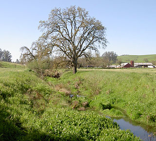
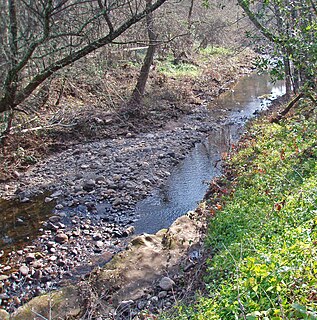
Piner Creek is a stream in northeast Santa Rosa, California, United States ( 38°27′40″N122°45′05″W / 38.46111°N 122.75139°W / 38.46111; -122.75139 ) which originates as an outlet of Fountaingrove Lake. Piner Creek discharges to Santa Rosa Creek which in turn joins the Laguna de Santa Rosa. [2] The upper reaches in the foothills of the Mayacamas Mountains are at elevations of 200 to 300 feet (60 to 90 meters), while the lower and middle reaches are located on the Santa Rosa Plain at elevations of between the 110- and 140-foot (33- and 43-meter) contours; [3] therefore, these lower reaches have a gradient of about 1:250 toward the southwest. Geologic studies in the lower and middle reaches of Piner Creek indicate groundwater levels ranging from three to 15 feet (one to 5 meters) below the surface. [4] Prior to extensive urban development of the middle and lower reaches, the landscape earlier bore extensive agricultural uses including plum orchards, which fruit was subsequently processed for prunes.

Stream A body of surface water flowing down a channel

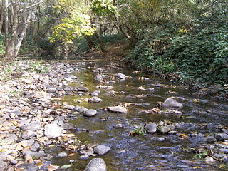
A stream is a body of water with surface water flowing within the bed and banks of a channel. The stream encompasses surface and groundwater fluxes that respond to geological, geomorphological, hydrological and biotic controls.

Santa Rosa, California City in California, United States

Santa Rosa is a city in and the county seat of Sonoma County, in California's Wine Country. Its estimated 2016 population was 175,155. Santa Rosa is the largest city in California's Redwood Empire, Wine Country and the North Bay; the fifth most populous city in the San Francisco Bay Area after San Jose, San Francisco, Oakland, and Fremont; and the 28th most populous city in California.

California State of the United States of America

California is a state in the Pacific Region of the United States. With 39.6 million residents, California is the most populous U.S. state and the third-largest by area. The state capital is Sacramento. The Greater Los Angeles Area and the San Francisco Bay Area are the nation's second- and fifth-most populous urban regions, with 18.7 million and 9.7 million residents respectively. Los Angeles is California's most populous city, and the country's second-most populous, after New York City. California also has the nation's most populous county, Los Angeles County, and its largest county by area, San Bernardino County. The City and County of San Francisco is both the country's second-most densely populated major city after New York City and the fifth-most densely populated county, behind only four of the five New York City boroughs.

Contents

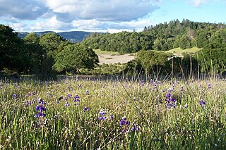
The Piner Creek watershed consists of 4,048 acres (16.4 km2), approximately three-fourths of which lies within the municipal boundaries of the city of Santa Rosa. [5] About one-third of the watershed is developed as residential use, and about one-sixth of the land is open space or used for recreation or agriculture. One of the early surviving architectural features of Sonoma County is within the Piner Creek catchment basin: A well preserved Round Barn, constructed in 1899, a testament to the 19th century pasturage uses within this watershed. [6]

Drainage basin Area of land where precipitation collects and drains off into a common outlet

A drainage basin is any area of land where precipitation collects and drains off into a common outlet, such as into a river, bay, or other body of water. The drainage basin includes all the surface water from rain runoff, snowmelt, and nearby streams that run downslope towards the shared outlet, as well as the groundwater underneath the earth's surface. Drainage basins connect into other drainage basins at lower elevations in a hierarchical pattern, with smaller sub-drainage basins, which in turn drain into another common outlet.

Pasture land used for grazing

Pasture is a concrete spatial area where farmers keep livestock for grazing.

Hydrology

Fountaingrove Lake, the origin of Piner Creek Fountaingrovelakelead.jpg
Fountaingrove Lake, the origin of Piner Creek

Piner Creek originates in the lower Mayacmas Mountains at Fountaingrove Lake. From its outlet at Fountaingrove Lake, Piner Creek flows down a relatively steep gradient, initially over a riprap lined channel, which has been modified in association with some alterations to lower Fountaingrove Lake. Thence Piner Creek flows northerly of an upscale modern office park before crossing under Redwood Highway and U.S. Highway 101. West of the U.S. 101 Freeway, Piner Creek winds through a retail and commercial/industrial area, before crossing under Piner Road near Coffey Lane; in this reach there is a large historic release to groundwater of solvent from manufacturing uses stemming back to the 1970s and 1980s.

Fountaingrove Lake reservoir in Santa Rosa, California

Fountaingrove Lake is a reservoir in the city of Santa Rosa, California, United States. Formed by the Fountaingrove Dam, the lake is fed from the east by Piner Creek, which is also the lake's sole outlet.

Riprap rock used for armouring structures

Riprap, also known as rip rap, rip-rap, shot rock, rock armor or rubble, is rock or other material used to armor shorelines, streambeds, bridge abutments, pilings and other shoreline structures against scour and water or ice erosion. Common rock types used include granite and limestone. Concrete rubble from building and paving demolition is sometimes used.

Retail is the process of selling consumer goods or services to customers through multiple channels of distribution to earn a profit. Retailers satisfy demand identified through a supply chain. The term "retailer" is typically applied where a service provider fills the small orders of a large number of individuals, who are end-users, rather than large orders of a small number of wholesale, corporate or government clientele. Shopping generally refers to the act of buying products. Sometimes this is done to obtain final goods, including necessities such as food and clothing; sometimes it takes place as a recreational activity. Recreational shopping often involves window shopping and browsing: it does not always result in a purchase.

Water quality of Piner Creek is characterized by pH levels that are mildly basic, with upper reach pH levels about 8.5, declining to lower reach levels at 7.8 just above the discharge to Santa Rosa Creek. [7] The headwaters soils are typically of pH about 6.9. Water quality of Piner Creek is generally low in turbidity, except for highest flow periods resulting from heavy rains; the water is free from odor. Springtime water temperatures are typically in the range of 60 to 65 degrees Fahrenheit (16 to 18 degrees Celsius).

pH measure of the acidity or basicity of an aqueous solution

In chemistry, pH is a scale used to specify how acidic or basic a water-based solution is. Acidic solutions have a lower pH, while basic solutions have a higher pH. At room temperature (25 °C), pure water is neither acidic nor basic and has a pH of 7.

Base (chemistry) substance that can accept hydrogen ions (protons) or more generally, donate a pair of valence electrons

In chemistry, bases are substances that, in aqueous solution, release hydroxide (OH) ions, are slippery to the touch, can taste bitter if an alkali, change the color of indicators (e.g., turn red litmus paper blue), react with acids to form salts, promote certain chemical reactions (base catalysis), accept protons from any proton donor or contain completely or partially displaceable OH ions. Examples of bases are the hydroxides of the alkali metals and the alkaline earth metals (NaOH, Ca(OH)2, etc.—see alkali hydroxide and alkaline earth hydroxide).

Turbidity The cloudiness of a fluid caused by large numbers of particles that are generally invisible to the naked eye

Turbidity is the cloudiness or haziness of a fluid caused by large numbers of individual particles that are generally invisible to the naked eye, similar to smoke in air. The measurement of turbidity is a key test of water quality.

Piner Creek terminates at its confluence with Santa Rosa Creek, which watercourse discharges to the Laguna de Santa Rosa; the Laguna de Santa Rosa ultimately forms a confluence with the Russian River, which flows into the Pacific Ocean.

Santa Rosa Creek stream in California

Santa Rosa Creek is a 22-mile-long (35 km) stream in Sonoma County, California, which rises on Hood Mountain and discharges to the Laguna de Santa Rosa by way of the Santa Rosa Flood Control Channel. This article covers both the creek and the channel.

Watercourse channel that a flowing body of water follows

A watercourse is the channel that a flowing body of water follows. In the UK, some aspects of criminal law, such as The Rivers Act 1951, specify that a watercourse includes those rivers which are dry for part of the year.

Laguna de Santa Rosa wetland in Sonoma County, California, USA

The Laguna de Santa Rosa is a 22-mile-long (35 km) wetland complex that drains a 254-square-mile (660 km2) watershed encompassing most of the Santa Rosa Plain in Sonoma County, California, United States.

Geology

Piner Creek before its confluence with Santa Rosa Creek, on the Santa Rosa Plain Pinercrabvstarosacrkconfl.jpg
Piner Creek before its confluence with Santa Rosa Creek, on the Santa Rosa Plain

As recently as the Miocene period, twelve million years ago, the entire watershed of Piner Creek was on the floor of the Pacific Ocean. After significant volcanic uplift and tectonic movement, the headwaters region of the Mayacmas Mountains emerged above the ocean. Piner Creek was one of the drainages that began to drain the new landmass, in formation of the eventual Santa Rosa Plain, through which the middle and lower reaches of Piner Creek flow. Occasional basaltic outcrops are seen in the upper reach of Piner Creek, betraying the volcanic origin of the Mayacmas Mountains. [8]

The Miocene is the first geological epoch of the Neogene Period and extends from about 23.03 to 5.333 million years ago (Ma). The Miocene was named by Charles Lyell; its name comes from the Greek words μείων and καινός and means "less recent" because it has 18% fewer modern sea invertebrates than the Pliocene. The Miocene is preceded by the Oligocene and is followed by the Pliocene.

Pacific Ocean Ocean between Asia and Australia in the west, the Americas in the east and Antarctica or the Southern Ocean in the south.

The Pacific Ocean is the largest and deepest of Earth's oceanic divisions. It extends from the Arctic Ocean in the north to the Southern Ocean in the south and is bounded by Asia and Australia in the west and the Americas in the east.

Basalt A magnesium- and iron-rich extrusive igneous rock

Basalt is a mafic extrusive igneous rock formed from the rapid cooling of magnesium-rich and iron-rich lava exposed at or very near the surface of a terrestrial planet or a moon. More than 90% of all volcanic rock on Earth is basalt. Basalt lava has a low viscosity, due to its low silica content, resulting in rapid lava flows that can spread over great areas before cooling and solidification. Flood basalt describes the formation in a series of lava basalt flows.

The upper reach of Piner Creek watershed is characterized by presence of Goulding cobbly clay loam soil; this soil has slopes of up to 15 percent and is subject to moderate erosive potential. [9] The actual soil depth is typically only about 20 inches (50 cm) and may contain up to 25 percent cobblestones. Historic use of this soil has been for grazing. As the stream approaches the Santa Rosa Plain immediately east of U.S Highway 101, slopes diminish to a gradient of five to 15 percent and the predominant soil type is Felta very gravelly loam. This Felta soil is characterized by an upper surface grayish-brown color and texture of a fine, sticky and plastic nature.

West of U.S. Highway 101, Piner Creek flows over the Santa Rosa Plain at gradients of less than two percent. Here the predominant soil type is Zamora silty clay loam, which has been deposited as an alluvial fan as the floodplain formed. [9] The upper soil surface of the Zamora material is grayish-brown hard, firm, sticky and plastic. Permeability is moderately slow and fertility is high for these lower reach soils, which has resulted in historic orchard use and present day vineyards.

Ecology

Formal habitat evaluation of Piner Creek has been conducted along with a number of other streams within the Laguna de Santa Rosa watershed. Habitat value of Piner Creek was found to be Fair compared to higher values scored by Matanzas Creek and Brush Creek and lower values scored by Colgan Creek. [5] Most of the watercourse has been modified to accommodate urban development within Santa Rosa, and some alterations have been conducted to achieve higher levels of flood control. The dominant tree along the banks of Piner Creek is the coast live oak, Quercus agrifolia ; within the streambed, a large number of cattail, Typha latifolia , stands are observed. A considerable number of bird species are found along the stream banks of Piner Creek.

Based upon benthic macroinvertebrate sampling in Piner Creek, a low faunal diversity was found; moreover a declining trend of such biodiversity was noted over the period 2000 to 2003. [5] In comparison with other streams of the Santa Rosa Creek watershed, Piner Creek was assessed to have above average epifaunal cover, riffle frequency and siltation characteristics. The high population level of tubificids in Piner Creek indicate the presence of excessive organic loading, [10] mostly due to high nitrate and phosphate runoff from urban uses (and possible reduced dissolved oxygen levels).

See also

Historic Round Barn, built in 1899, located in the Piner Creek watershed Roundbarnsocounty.jpg
Historic Round Barn, built in 1899, located in the Piner Creek watershed

Related Research Articles

Mayacamas Mountains mountain range in California

The Mayacamas Mountains are located in northwestern California in the United States. The mountain range is part of the Northern Inner Coast Ranges, of the California Coast Ranges System.

Trione-Annadel State Park state park of California

Trione-Annadel State Park is a state park of California in the United States. It is situated at the northern edge of Sonoma Valley and is adjacent to Spring Lake Regional Park in Santa Rosa. It offers many recreational activities within its 5,092-acre (2,061 ha) property.

Sonoma Creek stream in California

Sonoma Creek is a 33.4-mile-long (53.8 km) stream in northern California. It is one of two principal drainages of southern Sonoma County, California, with headwaters rising in the rugged hills of Sugarloaf Ridge State Park and discharging to San Pablo Bay, the northern arm of San Francisco Bay. The watershed drained by Sonoma Creek is roughly equivalent to the wine region of Sonoma Valley, an area of about 170 square miles (440 km2). The State of California has designated the Sonoma Creek watershed as a “Critical Coastal Water Resource”. To the east of this generally rectangular watershed is the Napa River watershed, and to the west are the Petaluma River and Tolay Creek watersheds.

Mount Hood (California) mountain in California

Mount Hood, also known as Hood Mountain is a mountain near the southeastern edge of Santa Rosa, California at the northeast of the Sonoma Valley and attains a height of 2,733 feet (833 m). The original name was Mount Wilikos, an Indian name meaning "willows." Most of the drainage from Mount Hood contributes to the headwaters of Sonoma Creek. A prominent feature is the extensive rock face visible on the upper half of the mountain as viewed from State Route 12. The habitats on the mountain include mixed oak forest, pygmy forest, chaparral and riparian zones. In prehistoric times the slopes of Mount Hood were inhabited by a division of the Yuki tribe. Most of Mount Hood is within the Hood Mountain Regional Park maintained by Sonoma County. Mount Hood is part of the inner coast Mayacamas Range, and lies mostly within Sonoma County, with a part of the mountain geographically within Napa County. Mount Hood affords overlooks of the Pacific Ocean, San Francisco Bay and "a spectacular view east to the Sierra Nevada Range."

Matanzas Creek stream in California

Matanzas Creek is an 11.4-mile-long (18.3 km) year-round stream in Sonoma County, California, United States, a tributary of Santa Rosa Creek.

Brush Creek (Sonoma County, California) stream in Sonoma County, California

Brush Creek or Rincon Creek is a tributary of Santa Rosa Creek in Sonoma County, California. Brush Creek rises in the southern slopes of the Mayacamas Mountains within Sonoma County. The lower reach of the creek is a suburban medium density residential area in the city of Santa Rosa, and that reach of Brush Creek has been restored during the 1990s under a U.S. Environmental Protection Agency grant to promote steelhead migration and spawning. Further restoration and incorporation into citywide park planning is currently underway as of 2006. The location of the confluence with Santa Rosa Creek is particularly noteworthy, since it was a locus of prehistoric life as a village of the Pomo people and a scenic geologic feature of massive flat boulder outcrops within the stream channel.

Fairfield Osborn Preserve nature reserve in California

The Fairfield Osborn Preserve is a 450 acre nature reserve situated on the northwest flank of Sonoma Mountain in Sonoma County, California. There are eight plant communities within the property, oak woodland being the dominant type. Other communities include chaparral, Douglas fir woodland, native Bunch grass, freshwater marsh, vernal pool, pond and riparian woodland. The flora is extremely diverse including many native trees, shrubs, wildflowers, grasses, lichens and mosses. A diverse fauna inhabits this area including black-tailed deer, coyote, bobcat and an occasional mountain lion; moreover, there are abundant avifauna, amphibians, reptiles and insects.

Copeland Creek stream in Sonoma County, California

Copeland Creek is a 9.0-mile-long (14.5 km) perennial stream that rises on Sonoma Mountain in Sonoma County, California.

Sonoma Mountains mountain range in California

The Sonoma Mountains are a northwest-southeast trending mountain range of the Inner Coast Ranges in the California Coast Ranges System, located in Sonoma County, Northern California.

Spring Creek (Sonoma County, California) stream in Sonoma County, California

Spring Creek, in Sonoma County, California, is a 6.0-mile-long (9.7 km) stream that rises in the northern part of the Sonoma Mountains within Annadel State Park, draining the western slopes of Taylor Mountain and feeding into Matanzas Creek below the Matanzas Creek Reservoir.

Yulupa Creek stream in California

Yulupa Creek is a 2.8-mile-long (4.5 km) southeast-flowing perennial stream that rises on the southeastern flanks of the northern Sonoma Mountains in Sonoma County, California, United States. This creek, which drains the eastern slopes of Bennett Mountain, is tributary to Sonoma Creek, which in turn discharges to San Pablo Bay.

Graham Creek is a 2.9-mile-long (4.7 km) perennial stream in Sonoma County, California, tributary to Sonoma Creek. Graham Creek rises in the northern Sonoma Mountains and flows generally northeasterly down the northeastern flank of Sonoma Mountain. Historically this watercourse was called Wild Water Creek, a name used in the time of author Jack London, some of whose work was inspired by the stream. Steelhead, Oncorhynchus mykiss, have historically entered Graham Creek via Sonoma Creek for spawning. Stream surveys conducted from 1966 to 1986 indicated significant, but declining populations of anadromous fish. The spawning habitat of Graham Creek is considered medium to high value, with both winter and summer sheltering characteristics.

Arroyo Seco Creek stream in Sonoma County, California

Arroyo Seco Creek, or simply Arroyo Seco, is a 6.9-mile-long (11.1 km) tributary stream to Schell Creek in southern Sonoma County, California, United States. In Spanish arroyo seco means "dry creek".

Washoe Creek perennial stream in California

Washoe Creek is a perennial stream located in Sonoma County, California. It is about 2 mi (3 km) long and discharges to the Laguna de Santa Rosa.

Calabazas Creek (Sonoma County) stream in Sonoma Valley, California

Calabazas Creek is a 5.5-mile-long (8.9 km) stream in the Sonoma Valley, California, United States, that rises in the southern Mayacamas Mountains and empties into Sonoma Creek near Glen Ellen.

Mark West Creek stream in California

Mark West Creek is a 29.9-mile-long (48.1 km) stream that rises in the Mayacamas Mountains of Sonoma County, California, United States. Tributaries of Mark West Creek include Porter Creek and Hummingbird Creek, both of which originate in the same mountain range. Discharge waters of Mark West Creek reach the Russian River after a confluence with the Laguna de Santa Rosa. The Community Clean Water Institute has developed a program for monitoring pollutants in Mark West Creek.

Crane Creek (California) stream in Sonoma County, California

Crane Creek is a stream in Sonoma County, California, United States which rises in the northern Sonoma Mountains. This watercourse flows through Crane Canyon and the Crane Creek Regional Park situated on the northwestern flank of Sonoma Mountain. Crane Creek forms a confluence with Hinebaugh Creek in the city of Rohnert Park; thereafter, the channelized Hinebaugh Creek flows westerly to discharge to the Laguna de Santa Rosa. Hiking access to the upper Crane Creek reaches is from Roberts Road off Petaluma Hill Road.

References

  1. 1 2 U.S. Geological Survey Geographic Names Information System: Fountaingrove Lake
  2. U.S. Geological Survey, Santa Rosa Quadrangle (1954, photorevised in 1980)
  3. U.S. Geological Survey, Aerial photograph stereo pair series (years 1957, 1965, and 1973)
  4. Environmental Site Assessment, 3230 and 3240 Coffey Lane, Santa Rosa, California Earth Metrics Incorporated, October 4, 1989
  5. 1 2 3 Biological and Physical/Habitat Assessment in the Santa Rosa Watershed (2002)
  6. History of Sonoma County, California Archived 2012-01-07 at the Wayback Machine .
  7. Water chemistry of the Laguna de Santa Rosa Watershed, Lumina Technologies, Santa Rosa, Ca. (2007)
  8. Volcanic Regions: Mayacamas and Sonoma Mountains
  9. 1 2 Soil Survey, Sonoma County, California, U.S. Department of Agriculture, Soil Conservation Service, Government Printing Office, Washington DC, May 1972
  10. E.B. Welch and T. Lindell, Ecological effects of wastewater , F P Spoon, London, England(2000)