Copeland Creek

Last updated
Copeland Creek
Copelandcrkfob.jpg
Copeland Creek with basalt armor in channel, Fairfield Osborn Preserve
Relief map of California.png
Red pog.svg
Location of the mouth of Copeland Creek in California
Location
Country United States
State California
Region Sonoma County
CitiesPenngrove, California, Rohnert Park, California
Physical characteristics
Source 
 - location Sonoma Mountain
 - coordinates 38°19′52″N122°34′38″W / 38.33111°N 122.57722°W / 38.33111; -122.57722 [1]
Mouth Laguna de Santa Rosa
 - location
west of Rohnert Park, California
 - coordinates
38°20′37″N122°43′25″W / 38.34361°N 122.72361°W / 38.34361; -122.72361 Coordinates: 38°20′37″N122°43′25″W / 38.34361°N 122.72361°W / 38.34361; -122.72361 [1]
 - elevation
92 ft (28 m) [1]

Copeland Creek is a 9.0-mile-long (14.5 km) [2] perennial stream that rises on Sonoma Mountain in Sonoma County, California. [3]

A perennial stream or perennial river is a stream or river (channel) that has continuous flow in parts of its stream bed all year round during years of normal rainfall. "Perennial" streams are contrasted with "intermittent" streams which normally cease flowing for weeks or months each year, and with "ephemeral" channels that flow only for hours or days following rainfall. During unusually dry years, a normally perennial stream may cease flowing, becoming intermittent for days, weeks, or months depending on severity of the drought. The boundaries between perennial, intermittent, and ephemeral channels are not defined, and subject to a variety of identification methods adopted by local governments, academics, and others with a need to classify stream-flow permanence.

Sonoma Mountain mountain in Sonoma County, California

Sonoma Mountain is a prominent landform within the Sonoma Mountains of southern Sonoma County, California. At elevation of 2,463 ft (751 m), Sonoma Mountain offers expansive views of the Pacific Ocean to the west and the Sonoma Valley to the east. In fact, the viticultural area extends in isolated patches up the eastern slopes of Sonoma Mountain to almost 1,700 feet (520 m) in elevation.

Sonoma County, California County in California, United States

Sonoma County is a county in the U.S. state of California. As of the 2010 United States Census, its population was 483,878. Its county seat and largest city is Santa Rosa. It is to the north of Marin County and the south of Mendocino County. It is west of Napa County and Lake County.

Contents

Description

The headwaters area is slightly above the Fairfield Osborn Preserve, while the middle reaches drain grazing land and vineyards on the lower western slopes of the Sonoma Mountains. Upon reaching the valley floor Copeland Creek bisects the campus of Sonoma State University on its journey to discharge into the Laguna de Santa Rosa. The Copeland Creek watershed is part of the Russian River basin, which drains to the Pacific Ocean.

Fairfield Osborn Preserve nature reserve in California

The Fairfield Osborn Preserve is a 450 acre nature reserve situated on the northwest flank of Sonoma Mountain in Sonoma County, California. There are eight plant communities within the property, oak woodland being the dominant type. Other communities include chaparral, Douglas fir woodland, native Bunch grass, freshwater marsh, vernal pool, pond and riparian woodland. The flora is extremely diverse including many native trees, shrubs, wildflowers, grasses, lichens and mosses. A diverse fauna inhabits this area including black-tailed deer, coyote, bobcat and an occasional mountain lion; moreover, there are abundant avifauna, amphibians, reptiles and insects.

Grazing method of feeding in which a herbivore eats parts of low-growing grasses, forbs or algae

Grazing is a method of feeding in which a herbivore feeds on plants such as grasses, or other multicellular organisms such as algae. In agriculture, grazing is one method used whereby domestic livestock are used to convert grass and other forage into meat, milk and other products.

Sonoma Mountains mountain range in California

The Sonoma Mountains are a northwest-southeast trending mountain range of the Inner Coast Ranges in the California Coast Ranges System, located in Sonoma County, Northern California.

History

The prehistory of this watershed and creek environment includes settlement by Coast Miwok, Wappo and Pomo peoples. These hunter gatherers dominated human usage until arrival of Europeans in the early 19th century. Rather swiftly an overgrazing situation arose not only in the lower reaches, but as high as the present Fairfield Osborn Preserve, which extends to elevation 1,700 feet (520 m). The upper reaches of the creek were effectively restored, following the purchase of the present lands of the Fairfield Osborn Preserve by William Matson Roth.

Human prehistory is the period between the use of the first stone tools c. 3.3 million years ago by hominins and the invention of writing systems. The earliest writing systems appeared c. 5,300 years ago, but it took thousands of years for writing to be widely adopted and it was not used in some human cultures until the 19th century or even until the present. The end of prehistory therefore came at very different dates in different places, and the term is less often used in discussing societies where prehistory ended relatively recently.

Coast Miwok tribe of Native American people

The Coast Miwok are an indigenous people that was the second largest group of Miwok people. The Coast Miwok inhabited the general area of modern Marin County and southern Sonoma County in Northern California, from the Golden Gate north to Duncans Point and eastward to Sonoma Creek. The Coast Miwok included the Bodega Bay Miwok, from authenticated Miwok villages around Bodega Bay, and the Marin Miwok.

Wappo indigenous people of Northern California

The Wappo are an indigenous people of northern California. Their traditional homelands are in Napa Valley, the south shore of Clear Lake, Alexander Valley, and Russian River valley.

The lower reaches were heavily disturbed as late as the 1990s, when a restoration of the reach between Roberts Road and Petaluma Hill Road was started. These lower reaches would have been historically heavily vegetated by native alder and arroyo willow. [4] However, cattle grazing and associated trampling of vegetation severely reduced spawning of anadromous fish: by altering stream cover that cooled water temperatures and by elevating turbidity, with resulting covering of spawning gravels. Some lower reaches between Roberts Road and the Fairfield Osborn Preserve are still subject to overgrazing as of 2006. Overgrazing has also exacerbated stream bank erosion, and led to invasive forbs and grasses supplanting the native riparian vegetation. This alteration of native riparian growth has further reduced populations of avafauna, amphibians and macro invertebrates.

Vegetation total of plant formations and plant communities

Vegetation is an assemblage of plant species and the ground cover they provide. It is a general term, without specific reference to particular taxa, life forms, structure, spatial extent, or any other specific botanical or geographic characteristics. It is broader than the term flora which refers to species composition. Perhaps the closest synonym is plant community, but vegetation can, and often does, refer to a wider range of spatial scales than that term does, including scales as large as the global. Primeval redwood forests, coastal mangrove stands, sphagnum bogs, desert soil crusts, roadside weed patches, wheat fields, cultivated gardens and lawns; all are encompassed by the term vegetation.

Alder genus of plants

Alder is the common name of a genus of flowering plants (Alnus) belonging to the birch family Betulaceae. The genus comprises about 35 species of monoecious trees and shrubs, a few reaching a large size, distributed throughout the north temperate zone with a few species extending into Central America, as well as the northern and southern Andes.

Willow genus of plants

Willows, also called sallows and osiers, form the genus Salix, around 400 species of deciduous trees and shrubs, found primarily on moist soils in cold and temperate regions of the Northern Hemisphere. Most species are known as willow, but some narrow-leaved shrub species are called osier, and some broader-leaved species are referred to as sallow. Some willows are low-growing or creeping shrubs; for example, the dwarf willow rarely exceeds 6 cm (2.4 in) in height, though it spreads widely across the ground.

Ecology

Partially submerged Pacific giant salamander larva, upper Copeland Creek. Pacificgiantsalamander2.jpg
Partially submerged Pacific giant salamander larva, upper Copeland Creek.

Principal plant communities within the upper reaches include the dominant California oak woodland, and also consist of Douglas-fir woodland and riparian woodland. Within the oak woodland the main tree species are coast live oak, Oregon oak, California black oak, canyon live oak and California bay laurel. The woodland understory exhibits toyon, coffeeberry, poison oak and numerous other flowering plants such as snowberry and the uncommon American ginseng.

California oak woodland

California oak woodland is a plant community found throughout the California chaparral and woodlands ecoregion of California in the United States and northwestern Baja California in Mexico. Oak woodland is widespread at lower elevations in coastal California; in interior valleys of the Coast Ranges, Transverse Ranges and Peninsular Ranges; and in a ring around the California Central Valley grasslands. The dominant trees are oaks, interspersed with other broadleaf and coniferous trees, with an understory of grasses, herbs, geophytes, and California native plants.

Woodland low-density forest forming open habitats with plenty of sunlight and limited shade

A woodland or wood is a low-density forest forming open habitats with plenty of sunlight and limited shade. Woodlands may support an understory of shrubs and herbaceous plants including grasses. Woodland may form a transition to shrubland under drier conditions or during early stages of primary or secondary succession. Higher density areas of trees with a largely closed canopy that provides extensive and nearly continuous shade are referred to as forests.

Riparian forest forested or wooded area of land adjacent to a body of water

A riparian forest or riparian woodland is a forested or wooded area of land adjacent to a body of water such as a river, stream, pond, lake, marshland, estuary, canal, sink or reservoir.

Upper reach wildlife includes the federally listed endangered red-legged frog. Upper reaches of Copeland Creek have a very high percentage population of California bay laurel, and also provide habitat for a rich variety of amphibians, newts and other fauna. The Pacific giant salamander, one of the largest known species of salamander is observed hunting for prey in upper Copeland Creek. Other amphibians seen in upper riparian habitats include the Pacific treefrog, Pseudacris regilla (formerly Hyla regilla), rough skinned newt, Taricha granulosa, and California slender salamander, Batrachoseps attenuatus.

Red-legged frog index of animals with the same common name

Red-legged frog is a common name for several species of frog:

Habitat ecological or environmental area inhabited by a particular species; natural environment in which an organism lives, or the physical environment that surrounds a species population

In ecology, a habitat is the type of natural environment in which a particular species of organism lives. It is characterized by both physical and biological features. A species' habitat is those places where it can find food, shelter, protection and mates for reproduction.

Amphibian A class of ectothermic tetrapods, which typically breed in water

Amphibians are ectothermic, tetrapod vertebrates of the class Amphibia. Modern amphibians are all Lissamphibia. They inhabit a wide variety of habitats, with most species living within terrestrial, fossorial, arboreal or freshwater aquatic ecosystems. Thus amphibians typically start out as larvae living in water, but some species have developed behavioural adaptations to bypass this. The young generally undergo metamorphosis from larva with gills to an adult air-breathing form with lungs. Amphibians use their skin as a secondary respiratory surface and some small terrestrial salamanders and frogs lack lungs and rely entirely on their skin. They are superficially similar to lizards but, along with mammals and birds, reptiles are amniotes and do not require water bodies in which to breed. With their complex reproductive needs and permeable skins, amphibians are often ecological indicators; in recent decades there has been a dramatic decline in amphibian populations for many species around the globe.

Management

Oversight of Copeland Creek is by the Sonoma County Water Agency; in the year 2006 the Agency cleared cattails and arroyo willow from certain lower reach portions of the creek in order to improve flow characteristics. [5] As with any flood control management strategy, unintended environmental impacts can arise from stream channel modification. The Sonoma County General Plan Open Space Element calls for a Copeland Creek Trail along Copeland Creek to connect Rohnert Park near Sonoma State University to Crane Creek Regional Park. [6] In addition, the 2003 County Outdoor Recreation Plan calls for a Copeland Creek Regional Park of about 500 acres (2.0 km2) to be situated near Fairfield Osborn Preserve at elevation 1,500 ft (460 m). [7] Through the city of Rohnert Park, the creek is largely channelized. [8]

The Sonoma County Water Agency in partnership with the California Department of Fish and Game have developed a strategy for enhancing spawning capability to the Russian River and a number of its tributaries; this activity was directed at the benefit of three threatened anadromous species: Coho salmon, Chinook salmon and steelhead. A Copeland Creek Restoration Project addressed the creek channel along approximately 6,000 ft (1,800 m) of Copeland Creek, which had been overgrazed by cattle for over 100 years. [9] Commencing in 1999, the project was implemented in four phases, the fourth and final phase of construction having been completed in the autumn of 2003. The project was designed to stabilize banks, decrease creek turbidity, exclude cattle from the creek by fencing, and improve habitat for steelhead and other native fish and wildlife. The outcome yielded a creek with less sediment load and a more natural undulation of channel, where an almost linear creek geometry had existed for the previously modified reach.

See also

Related Research Articles

Rohnert Park, California City in California in the United States

Rohnert Park is a city in Sonoma County, California, United States, located approximately 50 miles (80 km) north of San Francisco. The population at the 2010 United States Census was 40,971. It is an early planned city and is the sister city of Hashimoto in Japan. Sonoma State University, part of the California State University system, is located nearby.

Wine Country (California) area of Northern California known as a wine-growing region

Wine Country is the region of California, in the northern Bay Area, known worldwide as a premium wine-growing region. The region is famed for its wineries, its cuisine,, Michelin star restaurants, boutique hotels, luxury resorts, historic architecture, and culture. Viticulture and wine-making have been practiced in the region since the Spanish missionaries from Mission San Francisco Solano established the first vineyards in 1812.

Austin Creek State Recreation Area recreational area in California

Austin Creek State Recreation Area is a state park unit of California, United States, encompassing an isolated wilderness area. It is located in Sonoma County, California, adjacent to Armstrong Redwoods State Natural Reserve, with which it shares a common entrance. Its rugged topography includes ravines, grassy hillsides, oak-capped knolls, and rocky summits offering glimpses of the Pacific Ocean. There are 20 miles (30 km) of trails, panoramic wilderness views, and camping. The remains of Pond Farm artists' colony are also included in the Austin Creek SRA.

Trione-Annadel State Park state park of California

Trione-Annadel State Park is a state park of California in the United States. It is situated at the northern edge of Sonoma Valley and is adjacent to Spring Lake Regional Park in Santa Rosa. It offers many recreational activities within its 5,092-acre (2,061 ha) property.

Sonoma Creek stream in California

Sonoma Creek is a 33.4-mile-long (53.8 km) stream in northern California. It is one of two principal drainages of southern Sonoma County, California, with headwaters rising in the rugged hills of Sugarloaf Ridge State Park and discharging to San Pablo Bay, the northern arm of San Francisco Bay. The watershed drained by Sonoma Creek is roughly equivalent to the wine region of Sonoma Valley, an area of about 170 square miles (440 km2). The State of California has designated the Sonoma Creek watershed as a “Critical Coastal Water Resource”. To the east of this generally rectangular watershed is the Napa River watershed, and to the west are the Petaluma River and Tolay Creek watersheds.

Mount Hood (California) mountain in California

Mount Hood, also known as Hood Mountain is a mountain near the southeastern edge of Santa Rosa, California at the northeast of the Sonoma Valley and attains a height of 2,733 feet (833 m). The original name was Mount Wilikos, an Indian name meaning "willows." Most of the drainage from Mount Hood contributes to the headwaters of Sonoma Creek. A prominent feature is the extensive rock face visible on the upper half of the mountain as viewed from State Route 12. The habitats on the mountain include mixed oak forest, pygmy forest, chaparral and riparian zones. In prehistoric times the slopes of Mount Hood were inhabited by a division of the Yuki tribe. Most of Mount Hood is within the Hood Mountain Regional Park maintained by Sonoma County. Mount Hood is part of the inner coast Mayacamas Range, and lies mostly within Sonoma County, with a part of the mountain geographically within Napa County. Mount Hood affords overlooks of the Pacific Ocean, San Francisco Bay and "a spectacular view east to the Sierra Nevada Range."

Santa Rosa Creek stream in California

Santa Rosa Creek is a 22-mile-long (35 km) stream in Sonoma County, California, which rises on Hood Mountain and discharges to the Laguna de Santa Rosa by way of the Santa Rosa Flood Control Channel. This article covers both the creek and the channel.

Brush Creek (Sonoma County, California) stream in Sonoma County, California

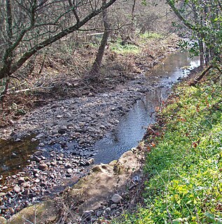
Brush Creek or Rincon Creek is a tributary of Santa Rosa Creek in Sonoma County, California. Brush Creek rises in the southern slopes of the Mayacamas Mountains within Sonoma County. The lower reach of the creek is a suburban medium density residential area in the city of Santa Rosa, and that reach of Brush Creek has been restored during the 1990s under a U.S. Environmental Protection Agency grant to promote steelhead migration and spawning. Further restoration and incorporation into citywide park planning is currently underway as of 2006. The location of the confluence with Santa Rosa Creek is particularly noteworthy, since it was a locus of prehistoric life as a village of the Pomo people and a scenic geologic feature of massive flat boulder outcrops within the stream channel.

California slender salamander species of amphibian

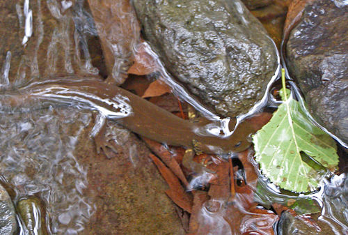
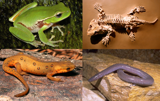
The California slender salamander is a lungless salamander that is found primarily in coastal mountain areas of Northern California, United States as well as in a limited part of the western foothills of the Sierra Nevada, California, in patches of the northern Central Valley of California, and in extreme southwestern Oregon. What makes this amphibian notable is that this species resides primarily in a limited range within California as one of a handful quasi-endemic amphibians in the state.

Laguna de Santa Rosa wetland in Sonoma County, California, USA

The Laguna de Santa Rosa is a 22-mile-long (35 km) wetland complex that drains a 254-square-mile (660 km2) watershed encompassing most of the Santa Rosa Plain in Sonoma County, California, United States.

Yulupa Creek stream in California

Yulupa Creek is a 2.8-mile-long (4.5 km) southeast-flowing perennial stream that rises on the southeastern flanks of the northern Sonoma Mountains in Sonoma County, California, United States. This creek, which drains the eastern slopes of Bennett Mountain, is tributary to Sonoma Creek, which in turn discharges to San Pablo Bay.

Graham Creek is a 2.9-mile-long (4.7 km) perennial stream in Sonoma County, California, tributary to Sonoma Creek. Graham Creek rises in the northern Sonoma Mountains and flows generally northeasterly down the northeastern flank of Sonoma Mountain. Historically this watercourse was called Wild Water Creek, a name used in the time of author Jack London, some of whose work was inspired by the stream. Steelhead, Oncorhynchus mykiss, have historically entered Graham Creek via Sonoma Creek for spawning. Stream surveys conducted from 1966 to 1986 indicated significant, but declining populations of anadromous fish. The spawning habitat of Graham Creek is considered medium to high value, with both winter and summer sheltering characteristics.

Washoe Creek perennial stream in California

Washoe Creek is a perennial stream located in Sonoma County, California. It is about 2 mi (3 km) long and discharges to the Laguna de Santa Rosa.

Calabazas Creek (Sonoma County) stream in Sonoma Valley, California

Calabazas Creek is a 5.5-mile-long (8.9 km) stream in the Sonoma Valley, California, United States, that rises in the southern Mayacamas Mountains and empties into Sonoma Creek near Glen Ellen.

Hinebaugh Creek stream in California

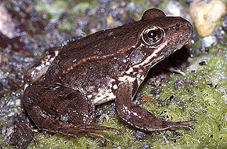
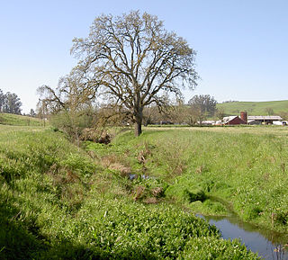
Hinebaugh Creek is a westward-flowing stream in western Sonoma County within the Laguna de Santa Rosa watershed. As this watercourse proceeds westerly through the city of Rohnert Park, it has largely been channelized and courses in an artificially straight alignment. Considered waters of the United States as a jurisdictional matter, Hinebaugh Creek is potential habitat for the California red-legged frog and the Western pond turtle. The dominant riparian vegetation is Himalayan blackberry and willow.

Crane Creek (California) stream in Sonoma County, California

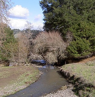
Crane Creek is a stream in Sonoma County, California, United States which rises in the northern Sonoma Mountains. This watercourse flows through Crane Canyon and the Crane Creek Regional Park situated on the northwestern flank of Sonoma Mountain. Crane Creek forms a confluence with Hinebaugh Creek in the city of Rohnert Park; thereafter, the channelized Hinebaugh Creek flows westerly to discharge to the Laguna de Santa Rosa. Hiking access to the upper Crane Creek reaches is from Roberts Road off Petaluma Hill Road.

Galbreath Wildlands Preserve

The Galbreath Wildlands Preserve is a 3,670-acre (14.9 km2) nature reserve in Mendocino County, California, USA, established in 2004 in honor of Fred Burckhalter Galbreath (1901-2000). The preserve, a former sheep ranch, is located near Yorkville.

References

  1. 1 2 3 U.S. Geological Survey Geographic Names Information System: Copeland Creek
  2. U.S. Geological Survey. National Hydrography Dataset high-resolution flowline data. The National Map Archived 2012-04-05 at WebCite , accessed March 9, 2011
  3. Santa Rosa Quadrangle, Fifteen minute series, USGS Quadrangle Map, U.S. Government Printing Office, Washington DC (1958)
  4. David Cook and Jessica Martini-Lamb, Copeland Creek Restoration Project Monitoring Plan,Sonoma County Water Agency, April, 2001
  5. Sonoma County Water Agency 2006 Maintenance Plan Archived 2007-07-23 at the Wayback Machine .
  6. Excerpts from Sonoma County General Plan pertaining to Copeland Creek Archived 2006-08-10 at the Wayback Machine .
  7. Sonoma County Outdoor Recreation Plan Park Summary Archived 2006-08-10 at the Wayback Machine .
  8. Earth Metrics Inc, Environmental Impact Report for the City of Rohnert Park General Plan, C. Michael Hogan, Marc Papineau, Ballard George et al. , published by the city of Rohnert Park, California and the State of California Environmental Clearinghouse, Sacramento, Ca., Report #10351, March 9, 1990
  9. Copeland Creek Fisheries Enhancement Program Archived October 2, 2009, at the Wayback Machine .