Theodore Dehone Judah was an American railroad and civil engineer who was a central figure in the original promotion, establishment, and design of the First Transcontinental Railroad. He found investors for what became the Central Pacific Railroad (CPRR). As chief engineer, he performed much of the land survey work to determine the best route for the railroad over the Sierra Nevada mountains.
Fremont is a city in Alameda County, California, United States. It was incorporated on January 23, 1956, from the annexing of Centerville, Niles, Irvington, Mission San José, and Warm Springs. The city is named after John C. Frémont, an American explorer and former US Senator from California, Governor from Arizona, Major General in the Union Army, and the first Republican presidential candidate, in 1856.

Benicia is a waterside city in Solano County, California, located in the North Bay region of the San Francisco Bay Area. It served as the state capital for nearly thirteen months from 1853 to 1854. The population was 26,997 at the 2010 census. The city is located along the north bank of the Carquinez Strait. Benicia is just east of Vallejo and across the strait from Martinez. Elizabeth Patterson has served as Mayor of Benicia since 2007.

Glenn County is a county in the U.S. state of California. As of the 2010 census, the population was 28,122. The county seat is Willows. It is located in the Sacramento Valley, in the northern part of the California Central Valley.
Lassen County is a county in the northeastern portion of the U.S. state of California. As of the 2010 census, the population was 34,895. The county seat and only incorporated city is Susanville.

Nevada County is a county in the Sierra Nevada of California. As of the 2010 census, the population was 98,764. The county seat is Nevada City.

Plumas County is a county in the Sierra Nevada of California, United States. As of the 2010 census, the population was 20,007. The county seat is Quincy, and the only incorporated city is Portola. The largest community in the county is East Quincy. The county was named for the Spanish Río de las Plumas, which flows through the county.

Sparks is a city in Washoe County, Nevada, United States. It was founded in 1904 and incorporated on March 15, 1905, and is located just east of Reno. The 2010 U.S. Census Bureau population count was 90,264. It is the fifth most populous city in Nevada. It is named after the late Nevada Governor John Sparks, a member of the Silver Party.
The Denver, Northwestern and Pacific Railway was a U.S. railroad company in Colorado. The company had numerous reorganizations throughout its financially troubled history, and later had the official names of the Denver and Salt Lake Railroad, and finally the Denver and Salt Lake Railway. By the time the company was acquired by the Denver and Rio Grande Western Railroad it was colloquially known as the Moffat Tunnel Route. The portions still in use today are known as the Moffat Tunnel Subdivision of Union Pacific Railroad's Central Corridor.

Donner Pass is a mountain pass in the northern Sierra Nevada, above Donner Lake about 9 miles (14 km) west of Truckee, California. Like the Sierra Nevada mountains themselves, the pass has a steep approach from the east and a gradual approach from the west.

Campo is a census-designated place (CDP) located in the Mountain Empire area of southeastern San Diego County, California. The population was 2,684 at the 2010 census.
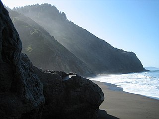
The Lost Coast is a mostly natural and undeveloped area of the California North Coast in Humboldt and Mendocino Counties, which includes the King Range. It was named the "Lost Coast" after the area experienced depopulation in the 1930s. In addition, the steepness and related geotechnical challenges of the coastal mountains made this stretch of coastline too costly for state highway or county road builders to establish routes through the area, leaving it the most undeveloped and remote portion of the California coast. Without any major highways, communities in the Lost Coast region such as Petrolia, Shelter Cove, and Whitethorn are isolated from the rest of California.

The Pacific Harbor Line was formed in 1998 to take over the Harbor Belt Line (HBL). In 1998, the Alameda Corridor was nearing completion, allowing for a massive amount of railroad traffic from the largest harbors in the Western hemisphere: Port of Los Angeles and Port of Long Beach.

The Oakland Terminal Railway was a terminal railroad in West Oakland, California. The OTR was jointly acquired in 1943 by the Western Pacific Railroad and Atchison, Topeka and Santa Fe Railway to take over the Key System's freight railroad known as the Oakland Terminal Railroad. Today, the OTR is now the West Oakland Pacific Railroad that operates on 10 miles of track. OTR was jointly owned by the Union Pacific Railroad and BNSF Railway. The railroad operated in the industrial area around the Oakland Army Base.

Dutch Flat is a small unincorporated community and census-designated place (CDP) in Placer County, California, United States, about 30 miles (48 km) northeast of Auburn along Interstate 80. It was founded by German immigrants in 1851 and was once one of the richest gold mining locations in California. Dutch Flat is now registered as a California Historical Landmark.

Mikon is an unincorporated community in Yolo County, California. It is located at the junction of the Southern Pacific and Sacramento Northern Railroads 1.25 miles (2.0 km) north-northwest of West Sacramento, at an elevation of 23 feet.
Navarro, formerly known as Wendling, is an unincorporated community in Mendocino County in the U.S. state of California. It is located 18 miles (29 km) west of Ukiah, at an elevation of 269 feet (82 m). It may be reached via east-west California State Route 128, which connects it to the Pacific coast to the west and to the Anderson Valley to the southeast.
Brockway is an unincorporated community in Placer County, California. Brockway is located on the north shore of Lake Tahoe on State Line Point, adjacent to the Nevada state border. It lies at an elevation of 6266 feet.