Temelec, California

Last updated
Temelec
Temelec Hall, 220 and 221 Temelec Circle, Temelec, CA 6-12-2010 2-05-54 PM (cropped).JPG
Temelec Hall
Sonoma County California Incorporated and Unincorporated areas Temelec Highlighted.svg
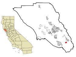
Location in Sonoma County and the state of California
Coordinates: 38°16′0″N122°29′34″W / 38.26667°N 122.49278°W / 38.26667; -122.49278 Coordinates: 38°16′0″N122°29′34″W / 38.26667°N 122.49278°W / 38.26667; -122.49278
Country Flag of the United States.svg  United States
State Flag of California.svg  California
County Sonoma
Area
[1]
  Total1.588 sq mi (4.113 km2)
  Land1.588 sq mi (4.113 km2)
  Water0 sq mi (0 km2)  0%
Elevation
[2]
98 ft (30 m)
Population
 (2010)
  Total1,441
  Density910/sq mi (350/km2)
Time zone UTC-8 (PST)
  Summer (DST) UTC-7 (PDT)
ZIP code
95476
Area code 707
FIPS code 06-78126
GNIS feature ID1799782
Reference no.237

Temelec (Miwok: Tamuleko) [3] [4] is a census-designated place (CDP) in Sonoma County, California, United States. The population was 1,441 at the 2010 census.

Contents

Temelec Hall

Temelec Hall Temelec Hall A - Stierch.jpg
Temelec Hall

Temelec is the site of Temelec Hall, built in 1858 by Captain Granville P. Swift, a member of the Bear Flag Party. The hall was owned by journalist Edmond Coblentz in the mid-1900s. [5] The hall is currently part of the Temelec Adult Community Center. Located at 220 Temelec Circle, it was designated California Historical Landmark #237. It is additionally a Sonoma County Historic Landmark.

Geography

According to the United States Census Bureau, the CDP has a total area of 1.6 square miles (4.1 km2), all land.

Demographics

2010

The 2010 United States Census [6] reported that Temelec had a population of 1,441. The population density was 907.4 inhabitants per square mile (350.3/km2). The racial makeup of Temelec was 1,376 (95.5%) White, 4 (0.3%) African American, 4 (0.3%) Native American, 31 (2.2%) Asian, 5 (0.3%) Pacific Islander, 5 (0.3%) from other races, and 16 (1.1%) from two or more races. Hispanic or Latino of any race were 68 persons (4.7%).

The Census reported that 100% of the population lived in households.

There were 960 households, out of which 8 (0.8%) had children under the age of 18 living in them, 318 (33.1%) were opposite-sex married couples living together, 45 (4.7%) had a female householder with no husband present, 12 (1.3%) had a male householder with no wife present. There were 30 (3.1%) unmarried opposite-sex partnerships, and 22 (2.3%) same-sex married couples or partnerships. 513 households (53.4%) were made up of individuals, and 398 (41.5%) had someone living alone who was 65 years of age or older. The average household size was 1.50. There were 375 families (39.1% of all households); the average family size was 2.07.

The population was spread out, with 11 people (0.8%) under the age of 18, 4 people (0.3%) aged 18 to 24, 23 people (1.6%) aged 25 to 44, 411 people (28.5%) aged 45 to 64, and 992 people (68.8%) who were 65 years of age or older. The median age was 71.5 years. For every 100 females, there were 63.9 males. For every 100 females age 18 and over, there were 63.6 males.

There were 1,051 housing units at an average density of 661.8 per square mile (255.5/km2), of which 86.7% were owner-occupied and 13.3% were occupied by renters. The homeowner vacancy rate was 3.9%; the rental vacancy rate was 6.5%. 87.2% of the population lived in owner-occupied housing units and 12.8% lived in rental housing units.

2000

As of the census [7] of 2000, there were 1,556 people, 989 households, and 452 families residing in the CDP. The population density was 919.0 inhabitants per square mile (354.8/km2). There were 1,045 housing units at an average density of 617.2 per square mile (238.3/km2). The racial makeup of the CDP was 96.53% White, 0.06% African American, 0.39% Native American, 1.74% Asian, 0.13% Pacific Islander, 0.13% from other races, and 1.03% from two or more races. Hispanic or Latino of any race were 2.63% of the population.

There were 989 households, out of which 0.1% had children under the age of 18 living with them, 41.8% were married couples living together, 3.7% had a female householder with no husband present, and 54.2% were non-families. 47.1% of all households were made up of individuals, and 37.3% had someone living alone who was 65 years of age or older. The average household size was 1.56 and the average family size was 2.07.

In the CDP, the population was spread out, with 0.2% under the age of 18, 0.4% from 18 to 24, 2.6% from 25 to 44, 22.6% from 45 to 64, and 74.3% who were 65 years of age or older. The median age was 73 years. For every 100 females, there were 66.8 males. For every 100 females age 18 and over, there were 66.6 males.

The median income for a household in the CDP was $36,964, and the median income for a family was $49,766. Males had a median income of $45,781 versus $38,889 for females. The per capita income for the CDP was $33,678. About 1.8% of families and 3.5% of the population were below the poverty line, including none of those under age 18 and 2.1% of those age 65 or over.

Politics

In the state legislature, Temelec is located in the 3rd Senate District, and in the 6th Assembly District.

Federally, Temelec is in California's 5th congressional district , represented by Republican Tom McClintock. [8]

Related Research Articles

<span class="mw-page-title-main">Rock Creek, Alabama</span> CDP in Alabama, United States

Rock Creek is a census-designated place in Jefferson County, Alabama, United States. Its location is northwest of Hueytown. At the 2020 census, the population was 1,471. This area was damaged by an F5 tornado on April 8, 1998. An EF2 tornado struck northwest from here on January 23, 2012.

<span class="mw-page-title-main">Underwood-Petersville, Alabama</span> Census-designated place in Alabama, United States

Underwood-Petersville is a census-designated place (CDP) in Lauderdale County, Alabama United States. It is part of the Florence - Muscle Shoals Metropolitan Statistical Area known as "The Shoals". As of the 2010 census, the population of the CDP is 3,247.

<span class="mw-page-title-main">Moores Mill, Alabama</span> Census-designated place in Alabama, United States

Moores Mill is an unincorporated community and census-designated place (CDP) in Madison County, Alabama, United States, and is included in the Huntsville-Decatur Combined Statistical Area. The population was 6,729 at the 2020 census, up from 5,682 at the 2010 census.

<span class="mw-page-title-main">Summit, Arizona</span> CDP in Pima County, Arizona

Summit is a census-designated place (CDP) in Pima County, Arizona, United States. The population was 3,702 at the 2000 census.

<span class="mw-page-title-main">Bayview-Montalvin, California</span> Former CDP in California, United States

Bayview-Montalvin is a former census-designated place (CDP) in Contra Costa County, California, United States. The population was 5,004 at the 2000 census.

<span class="mw-page-title-main">Boyes Hot Springs, California</span> Census designated place in California, United States

Boyes Hot Springs is a census-designated place (CDP) in Sonoma Valley, Sonoma County, California, United States. The population was 6,656 people at the 2010 census. Resorts in Boyes Hot Springs, El Verano, Fetters Hot Springs, and Agua Caliente were popular health retreats for tourists from San Francisco and points beyond until the middle of the 20th century because of the geothermic hot springs that still well up from deep within the earth.

<span class="mw-page-title-main">El Verano, California</span> Census-designated place in California, United States

El Verano is a census-designated place (CDP) in Sonoma Valley, Sonoma County, California, United States. The population was 4,123 at the 2010 census, falling to 3,867 at the 2020 census.

<span class="mw-page-title-main">Eldridge, California</span> Census-designated place in California, United States

Eldridge is a census-designated place (CDP) in Sonoma County, California, United States. The population was 1,233 at the 2010 census. It is notably the home to the Sonoma Developmental Center, the largest facility serving the needs of persons with developmental disabilities in the state.

<span class="mw-page-title-main">Fetters Hot Springs-Agua Caliente, California</span> Census-designated place in California, United States

Fetters Hot Springs-Agua Caliente is a census-designated place (CDP) in Sonoma Valley, Sonoma County, California, in the United States. As of the 2010 census, the CDP population was 4,144. The name Agua Caliente translates into English, from Spanish, as hot water, referring to the hot springs historically found in the area.

<span class="mw-page-title-main">Forestville, California</span> Census-designated place in California, United States

Forestville is a census-designated place (CDP) in Sonoma County, California, United States. It was settled during the late 1860s and was originally spelled Forrestville after one of its founders. The spelling long ago became standardized with one "r". The population was 3,293 at the 2010 census, an increase of nearly 1,000 since the 2000 census.

<span class="mw-page-title-main">Glen Ellen, California</span> Census designated place in California, United States

Glen Ellen is a census-designated place (CDP) in Sonoma Valley, Sonoma County, California, United States. The population was 784 at the 2010 census, down from 992 at the 2000 census. Glen Ellen is the location of Jack London State Historic Park, Sonoma Valley Regional Park, and a former home of Hunter S. Thompson.

<span class="mw-page-title-main">Graton, California</span> Census-designated place in California, United States

Graton is an unincorporated town and census-designated place (CDP) in west Sonoma County, California, United States. The population was 1,707 at the 2010 census. Graton's ZIP code is 95444. The town also has a culinary reputation attributed to two restaurants in the area.

<span class="mw-page-title-main">Monte Rio, California</span> Census-designated place in California, United States

Monte Rio is a census-designated place (CDP) in Sonoma County, California along the Russian River near the Pacific Ocean. The town of Guerneville lies northeast of Monte Rio, and Jenner is to the west. The population was 1,152 at the 2010 census, up from 1,104 at the 2000 census. Bohemian Grove is located in Monte Rio.

<span class="mw-page-title-main">Occidental, California</span> Census-designated place in California, United States

Occidental is a census-designated place (CDP) in Sonoma County, California, United States. The population was 1,115 at the 2010 census, down from 1,272 at the 2000 census.

Coyne Center is a census-designated place (CDP) in Rock Island County, Illinois, United States. The population was 827 at the 2010 census.

<span class="mw-page-title-main">South Gate, Maryland</span> Former census-designated place in Maryland, United States

South Gate was a census-designated place (CDP) in Anne Arundel County, Maryland, United States, for the 2000 census, at which time its population was 28,672. It was added primarily to the Glen Burnie CDP for the 2010 census.

<span class="mw-page-title-main">Stallion Springs, California</span> Census-designated place in California, United States

Stallion Springs is a census-designated place (CDP) in the Tehachapi Mountains, in Kern County, California, USA. The population was 2,488 at the 2010 census, up from 1,522 at the 2000 census. Stallion Springs is located in the greater Tehachapi Area.

<span class="mw-page-title-main">Greentree, New Jersey</span> Census-designated place in New Jersey, United States

Greentree is an unincorporated community and census-designated place (CDP) located within Cherry Hill Township, in Camden County, New Jersey, United States. As of the 2010 United States Census, the CDP's population was 11,367.

<span class="mw-page-title-main">Springdale, New Jersey</span> Census-designated place in New Jersey, United States

Springdale is an unincorporated community and census-designated place (CDP) located within Cherry Hill Township, in Camden County, New Jersey, United States. As of the 2010 United States Census, the section population was 14,518.

<span class="mw-page-title-main">Shiloh, York County, Pennsylvania</span> CDP in Pennsylvania, United States

Shiloh is a census-designated place (CDP) in West Manchester Township, York County, Pennsylvania, United States. The population was 11,218 at the 2010 census.

References

  1. U.S. Census Archived 2012-07-02 at the Wayback Machine
  2. U.S. Geological Survey Geographic Names Information System: Temelec
  3. Library of Congress - Temelec Hall
  4. Sonoma Valley Sun - Temelec is not a cheese
  5. "LeBaron: Tales of our scoundrel forebears". 10 September 2016.
  6. "2010 Census Interactive Population Search: CA - Temelec CDP". U.S. Census Bureau. Archived from the original on July 15, 2014. Retrieved July 12, 2014.
  7. "U.S. Census website". United States Census Bureau . Retrieved 2008-01-31.
  8. "California's 5th Congressional District - Representatives & District Map". Civic Impulse, LLC. Retrieved March 3, 2013.

See also