Venado, California

Last updated

Venado, California
VenadoPOSign.jpg
at the Healdsburg Museum
VenadoPO.jpg
Venado Post Office on Mill Creek Road
USA California location map.svg
Red pog.svg
Venado, California
Usa edcp location map.svg
Red pog.svg
Venado, California
Coordinates: 38°36′20″N123°00′29″W / 38.60556°N 123.00806°W / 38.60556; -123.00806
CountryUnited States
State California
County Sonoma
Elevation
1,102 ft (336 m)
Time zone UTC-8 (Pacific (PST))
  Summer (DST) UTC-7 (PDT)
Area code 707
GNIS feature ID1656386 [1]

Venado (Spanish for "venison") is an unincorporated community in Sonoma County, California, United States, and is located about 12 miles west of Healdsburg, along Mill Creek Road, below the north slope of Knoll Ridge, on the south bank of Gray Creek, at an elevation of 1,102 feet. The community had a post office from 1921 to 1941. Venado was devastated by the Walbridge Fire in 2020, part of the larger LNU Lightning Complex fire. The Walbridge Fire destroyed many homes and structures in the area, including the Venado Post Office and Daniels School.

Contents

History

The history of this area goes back to the 1860s when it was first settled by the Gray family. Venado was named by Stillman Batchellor, who served as postmaster, when a fourth class post office was established on May 7, 1921. Deliveries were three times a week, on Monday, Wednesday, and Friday. The service included mail in general with parcel post packages delivered to all patrons in the district, who must supply their own mail sacks made of heavy canvas material, being about two feet long, with a twenty-inch opening at the mouth, with the names and post office address printed or stamped thereon, along with a post or hook near the road in front of the house so the driver can hang the mail bag on the post without getting out of his vehicle.

The original post office building burned to the ground, and was replaced by one still standing, decaying under the redwoods. It is located on Mill Creek Road, 9.1 miles west of its junction with Westside Road. This post office was discontinued on November 15, 1941 with service transferred 12 miles east to Healdsburg, California.

Batchellor was a mining engineer turned fruitgrower, who settled in the area in the early 1900s after working in Cuba and Mexico. He owned an 11,000 acre ranch, which had land that when cleared, proved to be fine fruit land, with vineyards and prune orchards taking the place of redwood groves.

After 1863, California state law encouraged the building of schoolhouses three miles apart to accommodate the horse and buggy transportation, and a total of 15 one room schoolhouses were built by the early settlers of the small communities near Healdsburg. However, beginning in 1936, the one room schools began to unionize, and by 1951 only 5 one room schools remained.

Daniels School is over 120 years old, and is located on Mill Creek Road, across the road from Mill Creek, 2 miles east of Venado's post office, and about 10 miles west of Healdsburg, at an elevation of around 600 feet. Mill Creek parallels the road at this point, and flows by with the road and school on its right.

Daniels is a one-room school, measuring 284 square feet, and had one female teacher who taught first through eighth grades, but closed in 1951 due to lack of students. The original school building is still standing, and restoration is being planned by the Venado Historical Society. Known at first as Davis School, it was renamed in 1907 when R. A. Daniels agreed to move the school to its present location.

Daniels School Photo Tour

Felta School

Geography

Gray Creek begins at about 1,400 feet on the southeastern slopes of Vulture Ridge(1,481 feet), first flowing southeasterly, it parallels the north side of Mill Creek Road, as it passes Venado less than a mile from its headwaters, drains through a culvert to the south side of the road, then curves around the east and south ridges of Rabbit Knoll, as it changes to a southwesterly course, and flows down a steep-sided V-shaped canyon vegetated mainly by bay trees. Streamside vegetation is abundant with horsetails, azaleas, ferns, wild grapes, oaks and redwoods. Closely paralleling a dirt road along its journey, Gray Creek drains an area of approximately 5.1 square miles, and enters East Austin Creek on the left, just inside the northern boundary of the Austin Creek State Recreation Area, at an elevation of about 340 feet.

Located in the northeastern section of the Austin Creek watershed, Gray Creek is a 4.8 mile long tributary to East Austin Creek, which flows into Austin Creek, the Russian River and Pacific Ocean.

Rainfall

Venado is known for being a particularly rainy location with respect to the San Francisco Bay Area. [2] [3]

Nearby

On November 27, 1951 Felta School closed, along with Daniels and the three other remaining classic one room Sonoma County rural schools, as changing times, including demands for expanded resources and greater efficiency, required a new approach: consolidation.

Felta School, West Side Union School District, is a one-room schoolhouse built in 1906, that has been fully restored, is open to the public, and can be reserved for educational programs.

Located about 2 miles south of Healdsburg, on Felta Road near its junction with Westside Road, only a short distance from what is generally accepted to be the original mill that Mill Creek was named for.

Mill Creek waterfall MillCreekFalls.jpg
Mill Creek waterfall

March's Mill, one of the earliest sawmills in Sonoma County, California, gave Mill Creek its name in the 1850s, after William J. March and Samuel Heald founded their sawmill and lumber mill along Mill Creek, near its confluence with Felta Creek, in September 1850.

Mill Creek begins at about 1,400 feet on the northeastern slopes of Vulture Ridge, first flowing around the ridge's eastern spur, it proceeds down steep U-shaped Pickle Canyon in a southeasterly direction, before paralleling Mill Creek Road, passing Daniels School, and adding four major tributaries, draining a basin of approximately 24 square miles. Tan oak, alder, bay and redwoods forest the drainage area, and the federally protected northern spotted owl is listed by the California Department of Fish and Game as occurring in the Mill Creek watershed.

Located in the southwestern section of the Dry Creek watershed, Mill Creek is a tributary to Dry Creek and flows southeasterly for about 12 miles, entering Dry Creek on the right, near its confluence with the Russian River, at an elevation of about 60 feet.

Healdsburg Museum HealdsburgMuseum1.jpg
Healdsburg Museum

Related Research Articles

<span class="mw-page-title-main">Sonoma County, California</span> County in California, United States

Sonoma County is located in the U.S. state of California. As of the 2020 United States Census, its population was 488,863. Its seat of government and largest city is Santa Rosa. It is to the north of Marin County and the south of Mendocino County. It is west of Napa and Lake Counties.

<span class="mw-page-title-main">Santa Rosa, California</span> City in California, United States

Santa Rosa is a city in and the county seat of Sonoma County, in the North Bay region of the Bay Area in California. Its population as of the 2020 census was 178,127. It is the largest city in California's Wine Country and Redwood Coast. It is the fifth most populous city in the Bay Area after San Jose, San Francisco, Oakland, and Fremont; and the 25th most populous city in California.

<span class="mw-page-title-main">Armstrong Redwoods State Natural Reserve</span> State natural reserve in Sonoma County, California, United States

Armstrong Redwoods State Natural Reserve is a state park of California in the United States established to preserve 805 acres (326 ha) of coast redwoods. The reserve is located in Sonoma County, just north of Guerneville.

<span class="mw-page-title-main">Penngrove, California</span> Census-designated place in California, United States

Penngrove is a census-designated place (CDP) in Sonoma County, California, United States, situated between the cities of Petaluma and Cotati, at the foot of the western flank of Sonoma Mountain. It is part of the North Bay subregion of the San Francisco Bay Area. The population was 2,522 at the 2010 census.

Canyon, formerly known as Sequoya, is an unincorporated community located near the border of Contra Costa and Alameda counties, in the U.S. state of California. It is situated between Oakland and Moraga in the San Francisco Bay Area. The community is named for its location in the upper canyon of San Leandro Creek along the eastern slope of the Berkeley Hills. Canyon lies at an elevation of 1138 feet.

<span class="mw-page-title-main">Nicasio, California</span> Census-designated place in California, United States

Nicasio is an unincorporated community and census-designated place in Marin County, California, United States. It is located 8 miles (13 km) west-southwest of Novato, at an elevation of 194 feet (59 m). As of the 2020 census the CDP population was 81, while population estimates for the surrounding area range from about 600 to about 900 people.

<span class="mw-page-title-main">Cazadero, California</span> Unincorporated community in California, United States

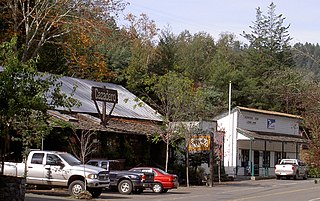
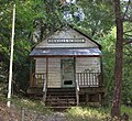
Cazadero is an unincorporated community and census-designated place (CDP) in western Sonoma County, California, United States with a population of 354 in 2010. The downtown of Cazadero consists of two churches, a general store, a post office, a hardware store, an auto repair garage, private office space, and the Cazadero Volunteer Fire Department.

<span class="mw-page-title-main">Northwestern Pacific Railroad</span> Regional railroad in California, US

The “Northwestern Pacific Railroad” was a 271 mile mainline railroad from the ferry connections in Sausalito north to Eureka with a connection to the national railroad system at Schellville. The railroad has gone through a history of different ownership and operators but has maintained a generic name of reference as “The Northwestern Pacific.” Currently, only a 62-mile (100 km) stretch of mainline on the “South End” is operated by Sonoma-Marin Area Rail Transit (SMART), which operates both commuter and freight trains with plans for future extension north to Cloverdale. The “North End,” from Willits to Eureka which includes connections to the California Western Railroad] is currently out of service but saved by 2018 legislation to be converted into the Great Redwood Trail.

<span class="mw-page-title-main">Russian River (California)</span> River in California

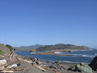
The Russian River is a southward-flowing river that drains 1,485 sq mi (3,850 km2) of Sonoma and Mendocino counties in Northern California. With an annual average discharge of approximately 1,600,000 acre feet (2.0 km3), it is the second-largest river flowing through the nine-county Greater San Francisco Bay Area, with a mainstem 115 mi (185 km) long.

<span class="mw-page-title-main">Sonoma Mountain</span> Highland in the North Bay region of California

Sonoma Mountain is a prominent landform within the Sonoma Mountains of southern Sonoma County, California. At an elevation of 2,463 ft (751 m), Sonoma Mountain offers expansive views of the Pacific Ocean to the west and the Sonoma Valley to the east. In fact, the viticultural area extends in isolated patches up the eastern slopes of Sonoma Mountain to almost 1,700 feet (520 m) in elevation.

<span class="mw-page-title-main">Laguna de Santa Rosa</span> River in California, United States

The Laguna de Santa Rosa is a 22-mile-long (35 km) wetland complex that drains a 254-square-mile (660 km2) watershed encompassing most of the Santa Rosa Plain in Sonoma County, California, United States.

<span class="mw-page-title-main">Sugarloaf Ridge State Park</span> State park in California, United States

Sugarloaf Ridge State Park is a state park in Northern California, United States. Located in the Mayacamas Mountains north of Kenwood, the park straddles the boundary between Sonoma and Napa counties. The park contains the 2,729-foot (832 m) Bald Mountain and the headwaters of Sonoma Creek including a 25-foot (8 m) tall seasonal waterfall. The park is also home to the volunteer-run Robert Ferguson Observatory. Camping, picnicking, horseback riding, mountain biking, stargazing, fishing and hiking are common attractions of Sugarloaf. The park boasts 25 miles of trails with trails ranging from less than a mile to 8.8 miles, and elevation gains reaching 2,500 feet.

<span class="mw-page-title-main">Austin Creek</span> Stream in Sonoma County, California

Austin Creek is a 16.0-mile-long (25.7 km) southward-flowing stream in the mountains of western Sonoma County, California which empties into the Russian River about 4 miles (6 km) from the Pacific Ocean.

Maacama Creek is a 7.3-mile-long (11.7 km) stream in northern Sonoma County, California, U.S.A., which empties into the Russian River near the city of Healdsburg.

<span class="mw-page-title-main">Windsor Creek</span> River in California, United States

Windsor Creek is an 8.8-mile-long (14.2 km) southward-flowing stream in Sonoma County, California, United States, which rises near Healdsburg, California, and feeds into Mark West Creek west of the Sonoma County Airport. Its waters reach the Pacific Ocean by way of the Russian River.

<span class="mw-page-title-main">Usal Creek</span> River in California, United States

Usal Creek is the southernmost drainage basin unbridged by California State Route 1 on California's Lost Coast. The unpaved county road following the westernmost ridge line south from the King Range crosses Usal Creek near the Pacific coast, but the bridge may be removed during winter months. Usal Creek, 9.7 miles (15.6 km) long, drains about 28 square miles (73 km2) on the Mendocino Coast and empties into the Pacific Ocean near the former company town of Usal.

<span class="mw-page-title-main">Annapolis, California</span> Unincorporated community in California, United States

Annapolis is an unincorporated community in Sonoma County, California, United States. Annapolis is situated near the coastline of northern Sonoma County, and is 5 miles (8.0 km) north-northeast of the nearest community, Stewarts Point. Annapolis has ZIP code 95412. The community is named after Annapolis Orchards, which was founded in the area in the 1880s. As of 2010, Annapolis has about 401 residents.

<span class="mw-page-title-main">Stewarts Point, California</span> Unincorporated community in California, United States

Stewarts Point is an unincorporated community in Sonoma County, California, United States and part of the "historic" Salt Point Township. Stewarts Point is located on the Pacific coast and California State Route 1, 20 miles (32 km) west of Healdsburg. Stewarts Point was originally part of the German Rancho, and was purchased by William Bihler in 1852. The unincorporated area is named for the first residents, the Stewart family, who moved to the area in 1856. In the official history for the United States Post Office, the name was said to have been given by Lt. Col. S. Stewart in 1888, however newspaper archives refer to the area as Stewarts Point as early as 1867, and attribute the name to the Stewart family who were the first residents in the area.

<span class="mw-page-title-main">LNU Lightning Complex fires</span> 2020 wildfire in California

The LNU Lightning Complex fires were a large complex of wildfires that burned during the 2020 California wildfire season across much of the Wine Country area of Northern California – Lake, Napa, Sonoma, Solano, and Yolo Counties, from August 17 to October 2, 2020. The complex was composed of numerous lightning-sparked fires, most of which were small. While they ignited separately from each other, the Hennessey Fire eventually grew to merge with the Gamble, Green, Markley, Spanish, and Morgan Fires, scorching 192,000 acres (777 km2) by itself, for a total burn area of 363,220 acres (1,470 km2) in the complex. The fire, which burned in the hills surrounding several large cities, such as Fairfield, Napa, and Vacaville, destroyed 1,491 structures and damaged a further 232. In all, six people were killed and another five injured. The LNU Lightning Complex is the sixth-largest wildfire in the recorded history of California.

References

Sources

Footnotes

  1. U.S. Geological Survey Geographic Names Information System: Venado, California
  2. "Bay Area's rainiest spot records 7 inches of rain in 24 hours". San Francisco Chronicle. Retrieved December 15, 2016.
  3. "13.68 Inches Of Rain Falls On Little-Known North Bay Town During Latest Storm". CBS Bay Area. Retrieved December 15, 2016.