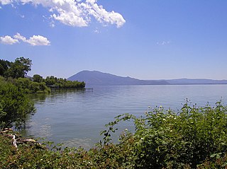
Lake County is a county located in the north central portion of the U.S. state of California. As of the 2020 census, the population was 68,163. The county seat is Lakeport. The county takes its name from Clear Lake, the dominant geographic feature in the county and the largest non-extinct natural lake wholly within California.

Mendocino County is a county located on the North Coast of the U.S. state of California. As of the 2020 census, the population was 91,601. The county seat is Ukiah.

Napa County is a county north of San Pablo Bay located in the northern portion of the U.S. state of California. As of the 2020 census, the population was 138,019. The county seat is the City of Napa. Napa County was one of the original counties of California, created in 1850 at the time of statehood. Parts of the county's territory were given to Lake County in 1861.

Sonoma County is located in the U.S. state of California. As of the 2020 United States Census, its population was 488,863. Its seat of government and largest city is Santa Rosa. It is to the north of Marin County and the south of Mendocino County. It is west of Napa and Lake Counties.

Rohnert Park is a city in Sonoma County, California, United States, located approximately 50 miles (80 km) north of San Francisco. The population at the 2020 United States Census was 44,390. It is an early planned city and is the sister city of Hashimoto in Japan. Sonoma State University, part of the California State University system, is located nearby.

Santa Rosa is a city in and the county seat of Sonoma County, in the North Bay region of the Bay Area in California. Its population as of the 2020 census was 178,127. It is the largest city in California's Wine Country and Redwood Coast. It is the fifth most populous city in the Bay Area after San Jose, San Francisco, Oakland, and Fremont; and the 25th-most populous city in California.
Sonoma is a city in Sonoma County, California, United States, located in the North Bay region of the San Francisco Bay Area. Sonoma is one of the principal cities of California's Wine Country and the center of the Sonoma Valley AVA. Sonoma's population was 10,739 as of the 2020 census, while the Sonoma urban area had a population of 32,679. Sonoma is a popular tourist destination, owing to its Californian wineries, noted events like the Sonoma International Film Festival, and its historic center.

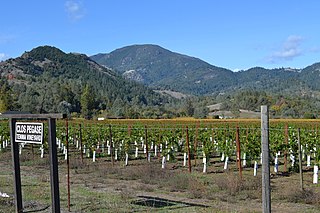
Wine Country is the region of California, in the northern San Francisco Bay Area, known worldwide as a premier wine-growing region. The region is famed for its wineries, its cuisine, Michelin star restaurants, boutique hotels, luxury resorts, historic architecture, and culture. Viticulture and wine-making have been practiced in the region since the Spanish missionaries from Mission San Francisco Solano established the first vineyards in 1812.

Sonoma Valley is a valley located in southeastern Sonoma County, California, in the North Bay region of the San Francisco Bay Area. Known as the birthplace of the California wine industry, the valley is home to some of the earliest vineyards and wineries in the state, some of which survived the phylloxera epidemic of the 1870s and the impact of prohibition in the early 20th century. Today, the valley's wines are promoted by the U.S. federal government's Sonoma Valley and Carneros AVAs.

The Mayacamas Mountains are located in northwestern California in the United States. The mountain range is part of the Northern Inner Coast Ranges, of the California Coast Ranges System.
California's 2nd congressional district is a U.S. congressional district in California. Jared Huffman, a Democrat, has represented the district since January 2013. Currently, it encompasses the North Coast region and adjacent areas of the state. It stretches from the Golden Gate Bridge to the Oregon border, and includes all of the portions of Highway 101 within California that are north of San Francisco, excepting a stretch in Sonoma County. The district consists of Marin, Mendocino, Humboldt, Del Norte, and Trinity Counties, plus portions of Sonoma County. Cities in the district include San Rafael, Petaluma, Novato, Windsor, Healdsburg, Ukiah, Fort Bragg, Fortuna, Eureka, Arcata, McKinleyville, Crescent City, and northwestern Santa Rosa.

Calabazas Creek is a 5.5-mile-long (8.9 km) stream in the Sonoma Valley, California, United States, that rises in the southern Mayacamas Mountains and empties into Sonoma Creek near Glen Ellen.
Mount Saint Helena is a peak in the Mayacamas Mountains with flanks in Napa, Sonoma, and Lake counties of California. Composed of uplifted volcanic rocks from the Clear Lake Volcanic Field, it is one of the few mountains in the San Francisco Bay Area to receive any snowfall during the winter.

Sugarloaf Ridge State Park is a state park in Northern California, United States. Located in the Mayacamas Mountains north of Kenwood, the park straddles the boundary between Sonoma and Napa counties. The park contains the 2,729-foot (832 m) Bald Mountain and the headwaters of Sonoma Creek including a 25-foot (8 m) tall seasonal waterfall. The park is also home to the volunteer-run Robert Ferguson Observatory. Camping, picnicking, horseback riding, mountain biking, stargazing, fishing and hiking are common attractions of Sugarloaf. The park boasts 25 miles of trails with trails ranging from less than a mile to 8.8 miles, and elevation gains reaching 2,500 feet.
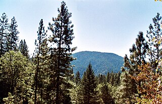
Cobb Mountain is the tallest mountain in the Mayacamas Mountains of California.
Rancho Mallacomes was a 17,742-acre (71.80 km2) Mexican land grant in present-day Napa County and Sonoma County, California given in 1843 by Governor Manuel Micheltorena to José de los Santos Berreyesa.
Preston is an unincorporated community in Sonoma County, California, United States. The community is on U.S. Route 101 2 miles (3.2 km) north of Cloverdale.
Lytton is an unincorporated community in Sonoma County, California, United States. The community is on U.S. Route 101, 3.4 miles (5.5 km) north of Healdsburg.

Bull Island is an island in the Napa River, in Napa County, California. From the 1880s onward, it was owned by the Money family, who constructed levees and reclaimed the land, using it to farm grain and potatoes. It was described as a "fine ranch" in 1918. After a levee failure in 1954, it gradually eroded into the water, becoming a salt marsh; for some time afterward, it was used as an evaporation pond for the industrial production of salt by the Leslie Salt Company. Beginning in the 1970s, Bull Island was proposed for inclusion in a variety of riparian preservation projects, but none came to fruition. However, in 1997, the Money family sold it to the California State Lands Commission, who turned it into a wildlife habitat; today it is administered as part of the Fagan Marsh Ecological Reserve, and hosts animals of numerous endangered species.

Russ Island is a mostly-submerged island in the Napa River, in Napa and Solano Counties, California. It was reclaimed in the late 19th century, and spent many years as productive farmland; in the 1950s, however, it was purchased by the Leslie Salt Company, and deliberately submerged to serve as an evaporation pond for salt production. The company allowed parts of it to be used for duck hunting. By the 1990s, it was acquired by the California Department of Fish and Game, who turned it into a wildlife preserve, and allowed it to return to marshland; it is now managed as part of the Napa-Sonoma Marshes Wildlife Area, and is open to hunting, fishing, birdwatching, photography and hiking activities.


