Mount Saint Helena

Last updated
Mount Saint Helena
Mount Saint Helena, viewed from Napa Valley.JPG
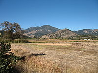
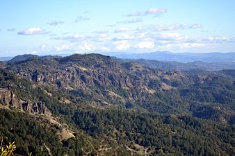
Mount Saint Helena, viewed from northern Napa Valley
Highest point
Elevation 4,342 ft (1,323 m)  NAVD 88 [1]
Prominence 1,823 ft (556 m) [2]
Listing California county high points 44th
Coordinates 38°40′10″N122°38′01″W / 38.669340858°N 122.633487528°W / 38.669340858; -122.633487528 Coordinates: 38°40′10″N122°38′01″W / 38.669340858°N 122.633487528°W / 38.669340858; -122.633487528 [1]
Geography
Relief map of Northern California.png
Red triangle with thick white border.svg
Mount Saint Helena
Parent range Mayacamas Mountains
Topo map USGS Mount Saint Helena
Climbing
Easiest route Hiking trail [3]

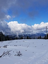
Mount Saint Helena (Wappo: Kanamota, "Human Mountain") [4] is a peak in the Mayacamas Mountains with flanks in Napa, Sonoma, and Lake counties of California. Composed of uplifted 2.4-million-year-old volcanic rocks from the Clear Lake Volcanic Field, it is one of the few mountains in the San Francisco Bay Area to receive any snowfall during the winter.

Contents

The mountain has five peaks, arranged in a rough "M" shape. Its highest point, North Peak, is in Sonoma County. The second-tallest, immediately east of the main summit, is the highest point in Napa County. [5] The headwaters of the Napa River arise on the southeast slope of Mount Saint Helena. [6] [7]

History

Replicas of a plaque left by Russians on Mount Saint Helena St Helena plate.JPG
Replicas of a plaque left by Russians on Mount Saint Helena

Mount Saint Helena has had an explosive history of pyroclastic flows that resulted in California's Petrified Forest.

Mount Saint Helena, originally named Kanamota ("Human Mountain") by the Wappo, and later Mount Mayacamas by Spanish colonists, was renamed by a Russian survey party who ascended the peak in 1841. They left a copper plate on the summit inscribed with the date of their visit and the name of Princess Helena de Gagarin, wife of Alexander G. Rotchev, the commanding officer of Fort Ross. [8] [9]

The peak is accessible by hiking trails leading from Robert Louis Stevenson State Park. [3] The trails are approximately 6 miles (9.7 km) long.

Scottish writer Robert Louis Stevenson and his wife Fanny Vandegrift Osbourne spent the summer of 1880 honeymooning in an abandoned mining camp on Mount Saint Helena. Stevenson's book The Silverado Squatters describes his experiences while living there. [3] A state park was named after him near here.

Representation in other media

The mount is described by Ambrose Bierce in his ghost story The Death of Halpin Frayser . Ursula K. Le Guin's novel Always Coming Home is about a post-apocalyptic society that considers Mount Saint Helena sacred.

Views from the summit

Top of Mount Saint Helena.jpg
Panorama from top of Mount Saint Helena.

See also

Related Research Articles

Napa County, California County in California, United States

Napa County is a county north of San Pablo Bay in the northern portion of the U.S. state of California. As of the 2020 census, the population was 138,019. The county seat is the City of Napa. Napa County was one of the original counties of California, created in 1850 at the time of statehood. Parts of the county's territory were given to Lake County in 1861.

St. Helena, California City in California, United States

St. Helena is a city in Napa County, in the Wine Country of California. Located in the North Bay region of the San Francisco Bay Area, the population was 5,814 at the 2010 census.

Wine Country Area of Northern California known as a wine-growing region

Wine Country is the region of California, in the northern Bay Area, known worldwide as a premier wine-growing region. The region is famed for its wineries, its cuisine, Michelin star restaurants, boutique hotels, luxury resorts, historic architecture, and culture. Viticulture and wine-making have been practiced in the region since the Spanish missionaries from Mission San Francisco Solano established the first vineyards in 1812.

Wappo Native American tribe in California

The Wappo are an indigenous people of northern California. Their traditional homelands are in Napa Valley, the south shore of Clear Lake, Alexander Valley, and Russian River valley. They are distantly related to the Yuki people, from which they seem to have diverged at least 500 years ago. Their language, Wappo, has been influenced by the neighboring Pomo, who use the term A'shochamai or A'shotenchawi, meaning "northerners", to refer to the Wappo.

Alexander Valley AVA

The Alexander Valley is a Californian American Viticultural Area (AVA) just north of Healdsburg in Sonoma County. It is home to many wineries and vineyards, as well as the city of Cloverdale. It is the largest and most fully planted wine region in Sonoma. Highway 101 runs through the valley, and the Russian River flows down the valley, surrounded by vineyards on both sides. From the higher elevations of the valley rim, there is a view as far south as Taylor Mountain and Sonoma Mountain. The region was named for Cyrus Alexander, owner of a part of the Rancho Sotoyome Mexican land grant, in 1847. Granted AVA status in 1984, the boundaries of the appellation are defined in the Code of Federal Regulations, Title 27, Section 9.53.

Mayacamas Mountains

The Mayacamas Mountains are located in northwestern California in the United States. The mountain range is part of the Northern Inner Coast Ranges, of the California Coast Ranges System.

Mount Konocti

Mount Konocti is a volcano in Lake County, California on the south shore of Clear Lake. At 4,305 feet (1,312 m), it is the second highest peak in the Clear Lake Volcanic Field, which consists of numerous volcanic domes and cones ranging from 10,000 to 2.1 million years old. Although it is often described as extinct, it is actually classified as High Threat Potential. Clear Lake Volcanic Field's alert level is currently classified as Normal.

<i>The Silverado Squatters</i> 1883 travel memoir by Robert Louis Stevenson

The Silverado Squatters (1883) is a travel memoir by Robert Louis Stevenson of his two-month honeymoon trip with Fanny Vandegrift to Napa Valley, California, in 1880.

Mount Hood (California)

Mount Hood, also known as Hood Mountain is a mountain near the southeastern edge of Santa Rosa, California at the northeast of the Sonoma Valley and attains a height of 2,733 feet (833 m). The original name was Mount Wilikos, an Indian name meaning "willows." Most of the drainage from Mount Hood contributes to the headwaters of Sonoma Creek. A prominent feature is the extensive rock face visible on the upper half of the mountain as viewed from State Route 12. The habitats on the mountain include mixed oak forest, pygmy forest, chaparral and riparian zones. In prehistoric times the slopes of Mount Hood were inhabited by a division of the Yuki tribe. Most of Mount Hood is within the Hood Mountain Regional Park maintained by Sonoma County. Mount Hood is part of the inner coast Mayacamas Range, and lies mostly within Sonoma County, with a part of the mountain geographically within Napa County. Mount Hood affords overlooks of the Pacific Ocean, San Francisco Bay and "a spectacular view east to the Sierra Nevada Range."

Napa Valley AVA is an American Viticultural Area located in Napa County in California's Wine Country. Napa Valley is considered one of the premier wine regions in the world. Records of commercial wine production in the region date back to the nineteenth century, but premium wine production dates back only to the 1960s.

Robert Louis Stevenson State Park State park in California, United States

Robert Louis Stevenson State Park is a California state park, located in Sonoma, Lake and Napa counties. The park offers a 5-mile (8 km) hike to the summit of Mount Saint Helena from which much of the Bay Area can be seen. On clear days it is possible to see the peak of Mount Shasta, 192 miles (310 km) distant.

Sugarloaf Ridge State Park State park in California, United States

Sugarloaf Ridge State Park is a state park in Northern California, United States. Located in the Mayacamas Mountains north of Kenwood, the park straddles the boundary between Sonoma and Napa counties. The park contains the 2,729-foot (832 m) Bald Mountain and the headwaters of Sonoma Creek including a 25-foot (8 m) tall seasonal waterfall. The park is also home to the volunteer-run Robert Ferguson Observatory. Camping, picnicking, horseback riding, mountain biking, stargazing, fishing and hiking are common attractions of Sugarloaf. The park boasts 25 miles of trails with trails ranging from less than a mile to 8.8 miles, and elevation gains reaching 2,500 feet.

Mark West Creek

Mark West Creek is a 29.9-mile-long (48.1 km) stream that rises in the Mayacamas Mountains of Sonoma County, California, United States. Tributaries of Mark West Creek include Porter Creek and Hummingbird Creek, both of which originate in the same mountain range. Discharge waters of Mark West Creek reach the Russian River after a confluence with the Laguna de Santa Rosa. The Community Clean Water Institute has developed a program for monitoring pollutants in Mark West Creek.

Cobb Mountain Mountain in California

Cobb Mountain is the tallest mountain in the Mayacamas Mountains of California.

Spring Mountain District AVA

The Spring Mountain District AVA is an American Viticultural Area located in the Napa Valley AVA in California. Spring Mountain District AVA was officially established as an American Viticulture Area in 1993. Encompassed within its bounds are about 8,600 acres (3,480 ha), of which about 1,000 acres (400 ha) are planted to vineyards. Given the small crop yields on hillsides, the region represents less than 2% of Napa Valley wine. Currently the region has just over 30 winegrowers.

Howell Mountains

The Howell Mountains, which are also known as the Mt. George Range, are one of the California Coast Ranges. They divide the Suisun Valley on the east side, from Napa Valley on the west. Historically the southern part of the range has been referred to as both the Sierra de Suscol and as the Sierra de Napa.

Sonoma Volcanics Geologic formation of volcanic origin in California

The Sonoma Volcanics are a geologic formation of volcanic origin that is widespread in Napa and Sonoma counties, California. Most of the formation is Pliocene in age and includes obsidian, perlitic glass, diatomaceous mud, pyroclastic tuff, pumice, rhyolite tuffs, andesite breccias and interbedded volcanic (basalt) lava flows. The formation serves as the parent material for many of the soils in the Napa and Sonoma wine regions.

Los Guillicos Preserve

The 40-acre Los Guillicos Preserve lies in the Valley of the Moon at the foot of Hood Mountain in the Mayacamas Mountain Range. Oak woodlands of the Preserve are within the Sonoma Creek Watershed. This land was included in the 1837 Rancho Los Guilicos Mexican Land Grant. Since 2011, the Preserve has been managed by Sonoma State University's Center for Environmental Inquiry.

Seigler Mountain is a mountain in the Mayacamas Mountains of the Northern California Coast Ranges. It is in Lake County, California.

Moon Mountain District Sonoma County

Moon Mountain District Sonoma County is an American Viticultural Area (AVA) within Sonoma Valley and North Coast viticultural areas, just north of the city of Sonoma. This mountainous region on the very eastern edge of Sonoma County has a historic reputation for producing rich, intensely-flavored wines from Cabernet Sauvignon and Syrah varietals since the 1880s. The District was established on November 1, 2013 by the Alcohol and Tobacco Tax and Trade Bureau (TTB). Its designation covers 17,663 acres (28 sq mi) of land stretching north-south along the western slopes of the Mayacamas mountains between Sugarloaf Ridge State Park and Los Carneros viticultural area with the Napa Valley’s Mount Veeder viticultural area outlining the eastern slopes. Its name is derived from Moon Mountain Road, which traverses through the area and itself a reference to Sonoma, which means 'valley of the moon' in the local Native American dialect. A clear view to San Francisco 50 miles (80 km) south is not uncommon from Moon Mountain District vineyards.

References

  1. 1 2 "Mount Helena". NGS data sheet. U.S. National Geodetic Survey . Retrieved 2009-08-14.
  2. "Mount Saint Helena, California". Peakbagger.com. Retrieved 2009-08-14.
  3. 1 2 3 "Mount St. Helena, Robert Louis Stevenson State Park". Greenbelt Alliance. Archived from the original on 2010-07-05. Retrieved 2009-08-14.
  4. "Wappo Language". Wappo Indians of Napa County. Archived from the original on 2012-02-08. Retrieved 2012-08-15.
  5. "Mount Saint Helena-East Peak, California". Peakbagger.com. Retrieved 2009-12-24.
  6. "Napa River". Geographic Names Information System . United States Geological Survey . Retrieved 2009-08-14.
  7. Kevin Courtney (March 28, 2010). "A search for Napa River's start runs through the heart of the valley". Napa Valley Register . Napa Valley Publishing.
  8. "Humboldt County, CA History". California Genealogy and History Archives. Retrieved 2009-08-14.
  9. "Napa County History". California Genealogy and History Archives. Archived from the original on 2009-03-27. Retrieved 2009-08-14.