Mount Hannah

Last updated
Mount Hannah
Relief map of California.png
Red triangle with thick white border.svg
Mount Hannah
Location in California
Highest point
Elevation 3,978 feet (1,212 m)
Prominence 1,338 feet (408 m)
Isolation 7.94 kilometres (4.93 mi)
to  Cobb Mountain
Coordinates 38°53′14″N122°44′47″W / 38.887258°N 122.746296°W / 38.887258; -122.746296
Geography
CountryUnited States
StateCalifornia
County Lake County
Geology
Mountain type Lava dome
Volcanic region Clear Lake volcanic field

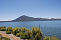
Mount Hannah is a mountain in the Mayacamas Mountains of the Northern California Coast Ranges. It is in Lake County, California.

Contents

Location

Mount Hannah is in Lake County, California. [1] It is one of the mountains in the Cobb Mountain Area, many of which have volcanic origin. Others are Cobb Mountain, the most dominant, Seigler Mountain and Boggs Mountain. There are isolated small valleys and basins between the mountain peaks. [2]

Mount Hannah has an elevation of 3,692 feet (1,125 m). Clean prominence is 1,338 feet (408 m). Isolation is 7.94 kilometres (4.93 mi). The nearest higher neighbor is Cobb Mountain to the south. [1]

Geology

Mount Hannah formed quite quickly during a polarity transition. [3] It was built up by a number of closely-spaced eruptions. [4] Three of the dacites in the Mount Hannah sequence have been dated to between 0.90 and 0.92 million years ago. [3] There are indications that there may be a crustal magma chamber about 10–15 kilometres (6.2–9.3 mi) in diameter and a depth of 15 kilometres (9.3 mi) below Mount Hannah, with a temperature above 550 °C (1,022 °F). [5]

Notes

    1. 1 2 Kirmse.
    2. Lake County Planning Department 1989, p. 3.1.
    3. 1 2 Iyer et al. 1980, p. 73.
    4. Iyer et al. 1980, p. 72.
    5. Iyer et al. 1980, p. 107.

    Sources

    Related Research Articles

    <span class="mw-page-title-main">Geography of California</span>

    California is a U.S. state on the western coast of North America. Covering an area of 163,696 sq mi (423,970 km2), California is among the most geographically diverse states. The Sierra Nevada, the fertile farmlands of the Central Valley, and the arid Mojave Desert of the south are some of the geographic features of this U.S. state. It is home to some of the world's most exceptional trees: the tallest, most massive, and oldest. It is also home to both the highest and lowest points in the 48 contiguous states.

    <span class="mw-page-title-main">Mount Shasta</span> Stratovolcano in California, United States

    Mount Shasta is a potentially active volcano at the southern end of the Cascade Range in Siskiyou County, California. At an elevation of 14,179 ft (4,322 m), it is the second-highest peak in the Cascades and the fifth-highest in the state. Mount Shasta has an estimated volume of 85 cubic miles, which makes it the most voluminous stratovolcano in the Cascade Volcanic Arc. The mountain and surrounding area are part of the Shasta–Trinity National Forest.

    <span class="mw-page-title-main">Mount Whitney</span> Highest mountain in the contiguous United States

    Mount Whitney is the highest mountain in the contiguous United States, with an elevation of 14,505 feet (4,421 m). It is in East–Central California, in the Sierra Nevada, on the boundary between California's Inyo and Tulare counties, and 84.6 miles (136.2 km) west-northwest of North America's lowest topographic point, Badwater Basin in Death Valley National Park, at 282 ft (86 m) below sea level. The mountain's west slope is in Sequoia National Park and the summit is the southern terminus of the John Muir Trail, which runs 211.9 mi (341.0 km) from Happy Isles in Yosemite Valley. The eastern slopes are in Inyo National Forest in Inyo County. Mount Whitney is ranked 18th by topographic isolation.

    <span class="mw-page-title-main">Mono–Inyo Craters</span> Volcanic chain in eastern California, United States

    The Mono–Inyo Craters are a volcanic chain of craters, domes and lava flows in Mono County, Eastern California. The chain stretches 25 miles (40 km) from the northwest shore of Mono Lake to the south of Mammoth Mountain. The Mono Lake Volcanic Field forms the northernmost part of the chain and consists of two volcanic islands in the lake and one cinder cone volcano on its northwest shore. Most of the Mono Craters, which make up the bulk of the northern part of the Mono–Inyo chain, are phreatic volcanoes that have since been either plugged or over-topped by rhyolite domes and lava flows. The Inyo volcanic chain form much of the southern part of the chain and consist of phreatic explosion pits, and rhyolitic lava flows and domes. The southernmost part of the chain consists of fumaroles and explosion pits on Mammoth Mountain and a set of cinder cones south of the mountain; the latter are called the Red Cones.

    <span class="mw-page-title-main">Klamath Mountains</span> Mountain range in Oregon and California, United States

    The Klamath Mountains are a rugged and lightly-populated mountain range in northwestern California and southwestern Oregon in the western United States. As a mountain system within both the greater Pacific Coast Ranges and the California Coast Ranges, the Klamath Mountains have a varied geology, with substantial areas of serpentinite and marble, and a climate characterized by moderately cold winters with very heavy snowfall and warm, very dry summers with limited rainfall, especially in the south. As a consequence of the geology and soil types, the mountains harbor several endemic or near-endemic trees, forming one of the largest collections of conifers in the world. The mountains are also home to a diverse array of fish and animal species, including black bears, large cats, owls, eagles, and several species of Pacific salmon. Millions of acres in the mountains are managed by the United States Forest Service. The northernmost and largest sub-range of the Klamath Mountains are the Siskiyou Mountains.

    <span class="mw-page-title-main">Mount Washington (Oregon)</span> Deeply eroded volcano in the Cascade Range of Oregon

    Mount Washington is a deeply eroded volcano in the Cascade Range of Oregon. It lies within Deschutes and Linn counties and is surrounded by the Mount Washington Wilderness area.

    <span class="mw-page-title-main">Mayacamas Mountains</span> Mountain range in northwestern California, United States

    The Mayacamas Mountains are located in northwestern California in the United States. The mountain range is part of the Northern Inner Coast Ranges, of the California Coast Ranges System.

    <span class="mw-page-title-main">Yamsay Mountain</span> Shield volcano mountain in Oregon, U.S.

    Yamsay Mountain is a large shield volcano in the Cascade Range of south-central Oregon, located about 35 miles (56 km) east of Crater Lake on the border between Klamath County and Lake County. It is part of the Cascade Volcanic Arc but is located in a mountain range 30 to 50 miles behind the main Cascade volcanic front. The best known members of this enigmatic arc are the massive shields of Newberry Volcano, about 55 miles (89 km) farther north in Oregon, and Medicine Lake Volcano, about 80 miles (130 km) south in Northern California. Yamsay is the second highest volcano in the eastern arc, almost 300 feet (90 m) higher than Newberry and Medicine Lake.

    <span class="mw-page-title-main">Cobb Mountain</span> Mountain in California

    Cobb Mountain is the tallest mountain in the Mayacamas Mountains of California.

    <span class="mw-page-title-main">Boggs Mountain Demonstration State Forest</span> State forest in California

    Boggs Mountain Demonstration State Forest is a state forest in Lake County, California that covers the northwest of Boggs Mountain. It was founded in 1949, and came into operation in 1950 when most of the site had been clear cut. The purpose was to demonstrate good practices in restoring and managing a forest. The state forest was open for recreational use, including camping, hiking, mountain biking etc. The 2015 Valley Fire destroyed 80% of the trees. The state forest as of 2021 was replanting saplings.

    <span class="mw-page-title-main">Forest Lake Resort</span> Resort in California, United States

    Forest Lake Resort was a resort in the Cobb Mountain area of Lake County, California, in an area of wet meadows along Kelsey Creek. Originally a campground, it was developed into a resort in the 1930s to exploit the growing automobile-based recreation market. The resort was sold in 1963. By 1989 it was longer operational, and was being considered for development as a community park site.

    Glenbrook was a resort in Lake County, California. It was located 10 miles (16 km) south-southeast of Kelseyville, at an elevation of 2293 feet.

    Lake Mojave is an ancient former lake fed by the Mojave River that, through the Holocene, occupied the Silver Lake and Soda Lake basins in the Mojave Desert of San Bernardino County, California. Its outlet may have ultimately emptied into the Colorado River north of Blythe.

    <span class="mw-page-title-main">Boggs Mountain</span> Mountain in the state of California

    Boggs Mountain is a mountain the Mayacamas Mountains in Lake County, California. Part of the mountain holds the Boggs Mountain Demonstration State Forest. About 80% of the trees were burned in the September 2015 Valley Fire.

    <span class="mw-page-title-main">Kelsey Creek (Lake County)</span> Watercourse in Lake Country, California, United States

    Kelsey Creek is a watercourse in Lake County, California, United States, that feeds Clear Lake from the south. Originally forest-covered, the watershed has been converted in the lower parts to farmland and for urban use. Higher up, the forests have been cleared, regrown, and cleared again. The northern part of the creek flows through a geothermal field that feeds power plants and hot springs. The wooded Cobb area in the higher part of the watershed was once home to resorts as early as the 1850s.

    The Bottle Rock Power Plant (BRPP) is a geothermal power plant in the Glenbrook Area of Lake County, California, United States.

    Seigler Mountain is a mountain in the Mayacamas Mountains of the Northern California Coast Ranges. It is in Lake County, California.

    Big Canyon Creek is a creek in Lake County, California. It is a tributary of Putah Creek.

    Mahnke Peak is a 3,652 feet (1,113 m) mountain in Mendocino County, California.