
The San Bernardino Mountains are a high and rugged mountain range in Southern California in the United States. Situated north and northeast of San Bernardino and spanning two California counties, the range tops out at 11,503 feet (3,506 m) at San Gorgonio Mountain – the tallest peak in all of Southern California. The San Bernardinos form a significant region of wilderness and are popular for hiking and skiing.

Mount Charleston, including Charleston Peak at 11,916 feet (3,632 m), is the highest mountain in both the Spring Mountains and Clark County, in Nevada, United States. It is the eighth-highest mountain in the state. Well separated from higher peaks by large, low basins, Charleston Peak is the most topographically prominent peak in Nevada, and the eighth-most-prominent peak in the contiguous United States. It is one of eight ultra-prominent peaks in Nevada. It is located about 35 miles (56 km) northwest of Las Vegas within the Mount Charleston Wilderness, which is within the Spring Mountains National Recreation Area of the Humboldt–Toiyabe National Forest.
Harbin Hot Springs is a non-profit hot spring retreat and workshop center at Harbin Springs in Lake County, Northern California. Named after Matthew Harbin, a pioneer who settled in the Lake County area. It is located about two hours northeast of the San Francisco Bay Area, in the United States. The facility was partially destroyed in the Valley Fire in September 2015, and was temporarily closed. In January 2019 it partially reopened, including the main pools and sauna, and a limited cafeteria service.

Mount Tom is a large and prominent peak near the city of Bishop in Inyo County of eastern California. It is in the Sierra Nevada and east of the Sierra Crest. The mountain is also in the John Muir Wilderness.

The New York Mountains are a small mountain range found in northeastern San Bernardino County in California, USA. The range's northeastern area lies in southeastern Nevada. The range lies just south of the small community of Ivanpah, and north of the Lanfair Valley. The mountains are part of the mountain ranges, cones, mountains, and landforms in the Mojave National Preserve. The mountains reach an elevation of 7,533 feet (2,296 m), and run in a mostly southwest-northeasterly direction between the Providence Mountains and the McCullough Range approximately five miles into Nevada and border the northwest corner of the Piute Valley of Nevada-California.
The Schell Creek Range is a linear mountain range in central White Pine County, in east-central Nevada. Its length is approximately 132 miles (212 km) in a north-south direction. Most of the range is contained within the Humboldt-Toiyabe National Forest, with some of the range also included in the High Schells Wilderness.

Split Mountain is a fourteener in the Sierra Nevada of the U.S. state of California, near the southeast end of the Palisades group of peaks. It is the only fourteener in the watershed of the South Fork Kings River, and rises to 14,064 ft (4,287 m), making it the eighth-highest peak in the state.
The Verdi Peaks, officially just Verdi Peak, are a group of three mountain peaks in the Ruby Mountains of Elko County, Nevada, United States. The highest peak is the fiftieth-highest in the state. The peaks are located on the edge of the Ruby Mountains Wilderness, within the Ruby Mountains Ranger District of the Humboldt-Toiyabe National Forest. They rise from the head of Talbot Canyon above Verdi Lake, and are a prominent part of the east wall of Lamoille Canyon above the Terraces Picnic Area. The two southern summits are directly on the Ruby Crest 5,000 feet (1,500 m) above the Ruby Valley to the east. The central summit is the highest of the three and is located about 25 miles (40 km) southeast of the city of Elko.

The Hot Creek Range is a volcanic mountain range in Nye County, in central Nevada in the western United States. From the historic community of Warm Springs, the range runs north-northeast for approximately 43 miles (69 km).
Cobb Mountain is the tallest mountain in the Mayacamas Mountains of California.
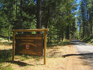
Boggs Mountain Demonstration State Forest is a state forest in Lake County, California that covers the northwest of Boggs Mountain. It was founded in 1949, and came into operation in 1950 when most of the site had been clear cut. The purpose was to demonstrate good practices in restoring and managing a forest. The state forest was open for recreational use, including camping, hiking, mountain biking etc. The 2015 Valley Fire destroyed 80% of the trees. The state forest as of 2021 was replanting saplings.
Temescal Mountains, also known as the Sierra Temescal, are one of the northernmost mountain ranges of the Peninsular Ranges in western Riverside County, in Southern California in the United States. They extend for approximately 25 mi (40 km) southeast of the Santa Ana River east of the Elsinore Fault Zone to the Temecula Basin and form the western edge of the Perris Block.

Hiking, rock climbing, and mountain climbing around Tuolumne Meadows in Yosemite National Park has many options.

Kuna Crest is a mountain range near Tuolumne Meadows, in Yosemite National Park, California.
Hope Valley is a broad mountain valley in Alpine County, California, located on the eastern slope of the Sierra Nevada to the northeast of Carson Pass and south of Lake Tahoe. The valley served as a major thoroughfare for the passage of settlers and emigrants to and from California during the Gold Rush era. Sitting at an elevation of just above 7,000 feet (2,100 m) and framed by peaks reaching over 10,000 feet (3,000 m) high, Hope Valley is known for its wide vistas, fly fishing, fall colors, and winter activities.
Boggs Mountain is a mountain the Mayacamas Mountains in Lake County, California. Part of the mountain holds the Boggs Mountain Demonstration State Forest. About 80% of the trees were burned in the September 2015 Valley Fire.

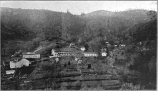
Kelsey Creek is a watercourse in Lake County, California, United States, that feeds Clear Lake from the south. The watershed was forest-covered. In the lower parts it has been converted to farmland and for urban use. Higher up the forests have been cleared, regrown and cleared again. The northern part of the creek flows through a geothermal field that feeds power plants and hot springs. The wooded Cobb area in the higher part of the watershed holds resorts and resort communities, some dating to the 1850s.
Big Canyon Creek is a creek in Lake County, California. It is a tributary of Putah Creek.
Mahnke Peak is a 3,652 feet (1,113 m) mountain in Mendocino County, California.

Cirque Peak is a 12,900-foot-elevation (3,900-meter) mountain summit located on the crest of the Sierra Nevada mountain range in California. It is situated on the common border of Tulare County with Inyo County, as well as the shared boundary of Golden Trout Wilderness and John Muir Wilderness, on land managed by Inyo National Forest. It is 14 miles (23 km) southwest of the community of Lone Pine, 7.7 miles (12.4 km) south-southeast of Mount Whitney, and 3.2 miles (5.1 km) south of Mount Langley, the nearest higher neighbor. Cirque Peak is the highest point of the Golden Trout Wilderness, and ranks as the 175th highest peak in California. Topographic relief is significant as it rises 1,800 feet above Cirque Lake in approximately one mile. The Pacific Crest Trail traverses the southwest slope of this mountain, providing an approach option. The mountain was apparently named in 1890 by Joseph Nisbet LeConte and companions who noted the remarkable cirque on the north aspect.

