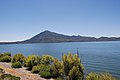
Cobb Mountain

Last updated
Cobb Mountain
Cobb Mountain.jpg
Highest point
Elevation 4723+ ft (1440+ m)  NAVD 88 [1]
Prominence 3,160 ft (963 m) [1]
Parent peak Crockett Peak
Listing California county high point 42nd
Coordinates 38°48′27″N122°44′26″W / 38.8074045°N 122.740546°W / 38.8074045; -122.740546 [2]
Geography
Relief map of California.png
Red triangle with thick white border.svg
Cobb Mountain
Location in California
Usa edcp relief location map.png
Red triangle with thick white border.svg
Cobb Mountain
Cobb Mountain (the United States)
Location Lake County, California, U.S.
Parent range Mayacamas Mountains
Topo map USGS Whispering Pines
Geology
Mountain type Lava dome
Southwest peak seen from the helipad to the south Cobb Moutain SW peak 4777.png
Southwest peak seen from the helipad to the south

Cobb Mountain is the tallest mountain in the Mayacamas Mountains of California.

Contents

Location

Cobb Mountain's 4,723 feet (1,440 m) main summit [1] is located in Lake County, west of the town of Cobb. Like nearby Mount Saint Helena, Cobb Mountain is tall enough to receive winter snowfall. [3] The mountain has a sub-peak referred to as Cobb Mountain – Southwest Peak with an elevation of about 4483+ feet, (1367+ m)  NAVD 88 ; [4] Southwest Peak lies on the Sonoma-Lake county line and is the highest point in Sonoma County. Nearby taller peaks like Mount Saint Helena and Snow Mountain can be seen from this summit. [5]

Cobb Mountain is one of the mountains in the Cobb Mountain Area, many of which have volcanic origin. Others are Boggs Mountain, Mount Hannah and Seigler Mountain. There are isolated small valleys and basins between the mountain peaks. [6]

The east end of Cobb Mountain drains into the headwaters of Putah Creek, then into the Sacramento River, the San Francisco Bay, and the Pacific Ocean. The south slopes of Cobb Mountain drain into Anderson Creek, and thence into Putah Creek. The southwest slopes of Cobb Mountain drain into Cobb Creek, thence into Big Sulphur Creek, the Russian River, and into the Pacific. The northwest slopes of Cobb Mountain drain into Alder Creek, thence into Kelsey Creek, Clear Lake, Cache Creek, and the Sacramento River. The northeast slopes of Cobb Mountain drain into Kelsey Creek. [7]

Much of Cobb Mountain lies within The Geysers Geothermal Field, and several geothermal plants are located on the mountain. Other areas on the mountain are owned by Cobb Mountain Spring Water (now sold as Mayacamas Mountain Spring Water) or are privately held timberlands. Because much of Cobb Mountain is privately owned, it is largely not accessible to the general public.

History

The mountain is named after John Cobb, the first pioneer to settle in the area. Cobb was born in Henry County, Kentucky on May 19, 1814. In 1853 he arrived in California and homesteaded in Cobb Valley and went on to become the county assessor and the road overseer for the Clearlake District in 1855. He built a combined saw and gristmill in 1859, which was later destroyed by fire. He sold his interests and moved to Napa County around 1860. [8]

The Cobb Mountain area was devastated in 2015 by the Valley Fire, including much of the town of Cobb, as well as several geothermal facilities. The catastrophic fire, the third-most destructive in California's history, started on Cobb Mountain as the result of faulty hot tub wiring according to Cal Fire. Four people died and a total 76,000 acres (31,000 ha) were burned over. [9]

Related Research Articles

<span class="mw-page-title-main">Mayacamas Mountains</span>

The Mayacamas Mountains are located in northwestern California in the United States. The mountain range is part of the Northern Inner Coast Ranges, of the California Coast Ranges System.

<span class="mw-page-title-main">Sonoma Creek</span> Stream in California

Sonoma Creek is a 33.4-mile-long (53.8 km) stream in northern California. It is one of two principal drainages of southern Sonoma County, California, with headwaters rising in the rugged hills of Sugarloaf Ridge State Park and discharging to San Pablo Bay, the northern arm of San Francisco Bay. The watershed drained by Sonoma Creek is roughly equivalent to the wine region of Sonoma Valley, an area of about 170 square miles (440 km2). The State of California has designated the Sonoma Creek watershed as a “Critical Coastal Water Resource”. To the east of this generally rectangular watershed is the Napa River watershed, and to the west are the Petaluma River and Tolay Creek watersheds.

<span class="mw-page-title-main">Mount Hood (California)</span>

Mount Hood, also known as Hood Mountain is a mountain near the southeastern edge of Santa Rosa, California at the northeast of the Sonoma Valley and attains a height of 2,733 feet (833 m). The original name was Mount Wilikos, an Indian name meaning "willows." Most of the drainage from Mount Hood contributes to the headwaters of Sonoma Creek. A prominent feature is the extensive rock face visible on the upper half of the mountain as viewed from State Route 12. The habitats on the mountain include mixed oak forest, pygmy forest, chaparral and riparian zones. In prehistoric times the slopes of Mount Hood were inhabited by a division of the Yuki tribe. Most of Mount Hood is within the Hood Mountain Regional Park maintained by Sonoma County. Mount Hood is part of the inner coast Mayacamas Range, and lies mostly within Sonoma County, with a part of the mountain geographically within Napa County. Mount Hood affords overlooks of the Pacific Ocean, San Francisco Bay and "a spectacular view east to the Sierra Nevada Range."

<span class="mw-page-title-main">Sonoma Mountain</span> Highland in the North Bay region of California

Sonoma Mountain is a prominent landform within the Sonoma Mountains of southern Sonoma County, California. At an elevation of 2,463 ft (751 m), Sonoma Mountain offers expansive views of the Pacific Ocean to the west and the Sonoma Valley to the east. In fact, the viticultural area extends in isolated patches up the eastern slopes of Sonoma Mountain to almost 1,700 feet (520 m) in elevation.

<span class="mw-page-title-main">Arroyo Seco (Sonoma County)</span> Stream in Sonoma County, California

Arroyo Seco is a 6.9-mile-long (11.1 km) tributary stream to Schell Creek in southern Sonoma County, California, United States. In Spanish arroyo seco means "dry creek".

<span class="mw-page-title-main">Dorset Mountain</span>

Dorset Mountain, on the border of Rutland and Bennington counties in Vermont, is part of the Taconic Range. The summit of Dorset Mountain is in Danby. An unmaintained hiking trail ascends from the southwest.

<span class="mw-page-title-main">Mount Saint Helena</span> Mountain in California, United States

Mount Saint Helena is a peak in the Mayacamas Mountains with flanks in Napa, Sonoma, and Lake counties of California. Composed of uplifted 2.4-million-year-old volcanic rocks from the Clear Lake Volcanic Field, it is one of the few mountains in the San Francisco Bay Area to receive any snowfall during the winter.

<span class="mw-page-title-main">Santanoni Peak</span> Mountain in New York state, US

Santanoni Peak is a mountain located in Essex County, New York. The mountain is part of the Santanoni Mountains of the Adirondacks. The mountain's name is believed to be an Abenaki derivative of "Saint Anthony"; the first French fur traders and missionaries having named the area for Saint Anthony of Padua. Santanoni Peak is flanked to the north by Panther Peak, and to the southwest by Little Santanoni Mountain.

<span class="mw-page-title-main">Street Mountain (New York)</span> Mountain in the United States

Street Mountain is a mountain located in Essex County, New York, named after Alfred Billings Street (1811–1881), a poet and New York State Librarian. The mountain is the high point of the Street Range of the Adirondack Mountains. Street's northeast ridge is Nye Mountain.

<span class="mw-page-title-main">Southwest Hunter Mountain</span> Mountain in United States of America

Southwest Hunter Mountain (Leavitt Peak) is a subpeak of Hunter Mountain, located in Greene County, New York. It is considered one of the Catskills' High Peaks in its own right, because of its separation from the main summit, and its topographic prominence. Hunter Mountain is named after John Hunter, who also gave his name to the town of Hunter.

<span class="mw-page-title-main">Vaca Mountains</span>

The Vaca Mountains are a mountain range in Napa and Solano Counties, California that is one of the California Coast Ranges. They represent the easternmost of the Inner Coast Ranges in north−central California, and divide the Suisun Valley on their west, from the Sacramento Valley on their east.

<span class="mw-page-title-main">Valley Fire</span> Wildfire in Lake County, California

The Valley Fire was a wildfire during the 2015 California wildfire season that started on September 12 in Lake County, California. It began shortly after 1:00 pm near Cobb with multiple reports of a small brush fire near the intersection of High Valley and Bottlerock Roads. It quickly spread and by 6:30 PM PDT, it had burned more than 10,000 acres (40 km2). By Sunday, the thirteenth of September, the fire had reached 50,000 acres (202 km2) and had destroyed much of Cobb, Middletown, Whispering Pines, and parts in the south end of Hidden Valley Lake. The fire ultimately spread to 76,067 acres (308 km2), killed four people and destroyed nearly 2,000 buildings, before it was fully contained on October 15, 2015, causing at least $921 million in insured property damage. At the time, the fire was the third-most destructive fire in California history, based on the total structures burned, but the Camp Fire (2018) and the North Complex fire in 2020, exceeded that total.

<span class="mw-page-title-main">Boggs Mountain</span> Mountain in the state of California

Boggs Mountain is a mountain the Mayacamas Mountains in Lake County, California. Part of the mountain holds the Boggs Mountain Demonstration State Forest. About 80% of the trees were burned in the September 2015 Valley Fire.

<span class="mw-page-title-main">Kelsey Creek (Lake County)</span> Watercourse in Lake Country, California, United States

Kelsey Creek is a watercourse in Lake County, California, United States, that feeds Clear Lake from the south. The watershed was forest-covered. In the lower parts it has been converted to farmland and for urban use. Higher up the forests have been cleared, regrown and cleared again. The northern part of the creek flows through a geothermal field that feeds power plants and hot springs. The wooded Cobb area in the higher part of the watershed holds resorts and resort communities, some dating to the 1850s.

Seigler Mountain is a mountain in the Mayacamas Mountains of the Northern California Coast Ranges. It is in Lake County, California.

Harbin Mountain is a mountain in Lake County, California. It may be seen as a high point on a spur of Boggs Mountain or as a connected mountain to the southeast of Boggs Mountain.

Mahnke Peak is a 3,652 feet (1,113 m) mountain in Mendocino County, California.

<span class="mw-page-title-main">Rivers of Lake County, California</span>

Rivers and creeks in Lake County, California are listed below by river basin and alphabetically. Unless otherwise stated, the information is taken from the Geographic Names Information System maintained by the United States Geological Survey. Coordinates, elevations and lengths from this source are approximate.

<span class="mw-page-title-main">Moon Mountain District Sonoma County</span>

Moon Mountain District Sonoma County is an American Viticultural Area (AVA) within Sonoma Valley and North Coast viticultural areas, just north of the city of Sonoma. This mountainous region on the very eastern edge of Sonoma County has a historic reputation for producing rich, intensely-flavored wines from Cabernet Sauvignon and Syrah varietals since the 1880s. The District was established on November 1, 2013 by the Alcohol and Tobacco Tax and Trade Bureau (TTB). Its designation covers 17,663 acres (28 sq mi) of land stretching north-south along the western slopes of the Mayacamas mountains between Sugarloaf Ridge State Park and Los Carneros viticultural area with the Napa Valley’s Mount Veeder viticultural area outlining the eastern slopes. Its name is derived from Moon Mountain Road, which traverses through the area and itself a reference to Sonoma, which means 'valley of the moon' in the local Native American dialect. A clear view to San Francisco 50 miles (80 km) south is not uncommon from Moon Mountain District vineyards.

<span class="mw-page-title-main">Mount Baldwin (California)</span> Mountain in the state of California

Mount Baldwin is a 12,614-foot-elevation (3,845-meter) mountain summit located in the Sierra Nevada mountain range in Mono County of northern California, United States. It is situated in the John Muir Wilderness on land managed by Inyo National Forest. It is four miles north of Red and White Mountain, and approximately 10.5 miles (16.9 km) southeast of the community of Mammoth Lakes. The nearest higher neighbor is Red Slate Mountain, 2 miles (3.2 km) to the south-southwest. Baldwin ranks as the 257th highest summit in California. Topographic relief is significant as the east aspect rises 3,775 feet above McGee Canyon in 1.5 mile. The first ascent of the summit was made July 2, 1928, by Norman Clyde, who is credited with 130 first ascents, most of which were in the Sierra Nevada.

References

  1. 1 2 3 "Cobb Mountain, California". Peakbagger.com. Retrieved 2009-07-05.
  2. "Cobb Mountain". Geographic Names Information System . United States Geological Survey, United States Department of the Interior . Retrieved 2009-07-05.
  3. "Subsection M261Be Konocti Flows". USDA, Forest Service. Archived from the original on 2011-09-22. Retrieved 2007-10-07.
  4. "Cobb Mountain-Southwest Peak, California". Peakbagger.com. Retrieved 2009-07-05.
  5. Height and visual lines-of-sight are based on Google Earth images.
  6. Lake County Planning Department 1989, p. 3.1.
  7. Whispering Pines quadrangle, California (Map). 1:24000. 7.5 Minute Topographic. USGS . Retrieved 2010-01-04.
  8. Mauldin, Henry (1995). Mountains & Pioneers of Lake County. Kelseyville, CA: Earthen Vessels Productions, Inc. p. 10. ISBN   978-1-887400-22-0.
  9. Stoneberg, David (2016-08-10). "Faulty hot tub blamed for last fall's massive Valley Fire". Napa Valley Register. Napa Valley, California. Retrieved 2021-10-29.

Sources