
Lake Pillsbury is a lake in the Mendocino National Forest of Lake County, California, created from the Eel River and Hull Mountain watershed by Scott Dam. Elevation is 1,818 ft (554 m) with 65 mi (105 km) of shoreline and covering 2,003 acres (811 ha). Activities in the Lake Pillsbury Recreation Area include powerboating, fishing, swimming, sailing, picnicking, hiking and hang gliding. There are two main access roads to the lake. At the north end of the lake is a small gravel airstrip. About 400 vacation cabins including National Forest Recreational Residences ring the lake.

East Fork Russian River is a 15 mi (24 km) long tributary of the Russian River in Mendocino County, California artificially connected to the Eel River via an interbasin diversion at the Potter Valley Project hydroelectric facility. It forms in the north of Potter Valley, flows south through this valley, then southwest through a mountain pass to Lake Mendocino, an artificial reservoir that empties into Russian River. At one time Clear Lake to the east drained through Cold Creek then along the lower part of East Fork Russian River through Coyote Valley to the Russian River proper. A few hundred years ago a massive landslide blocked this channel, and Clear Lake found a new outlet to the Sacramento River.
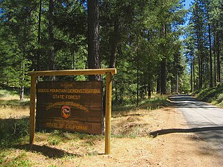
Boggs Mountain Demonstration State Forest is a state forest in Lake County, California that covers the northwest of Boggs Mountain. It was founded in 1949, and came into operation in 1950 when most of the site had been clear cut. The purpose was to demonstrate good practices in restoring and managing a forest. The state forest was open for recreational use, including camping, hiking, mountain biking etc. The 2015 Valley Fire destroyed 80% of the trees. The state forest as of 2021 was replanting saplings.
Glenbrook was a resort in Lake County, California. It was located 10 miles (16 km) south-southeast of Kelseyville, at an elevation of 2293 feet.

Witter Springs is a set of springs that was turned into a resort in the 1870s in Lake County, California.

The South Fork Eel River is the largest tributary of the Eel River in north-central California in the United States. The river flows 105 miles (169 km) north from Laytonville to Dyerville/Founders' Grove where it joins the Eel River. The South Fork drains a long and narrow portion of the Coast Range of California in parts of Mendocino and Humboldt counties. U.S. Route 101 follows the river for much of its length.

The Blue Ridge Berryessa Natural Area is a conservation area forming a contiguous corridor of 800,000 acres (3,200 km2) in northern California. It is a mix of public and private lands overseen by the Blue Ridge Berryessa Natural Area Conservation Partnership. The Partnership was founded in 1997 as a forum for land managers to discuss land use activities, primarily Homestake Mining Company surplus acreage at McLaughlin mine. The meetings evolved into a regional conservation focus and effort.

The Rice Fork is a 22.7-mile-long (36.5 km) tributary of the Eel River in Lake County, California. The Rice Fork begins on the upper northwest side of Goat Mountain, on the Colusa-Lake County line, at an elevation of over 6,000 feet (1,800 m). It quickly descends the steep western slope of the mountain, then bends northward, and flows northwesterly down a narrow winding steep walled canyon for about 18 miles (29 km), crossing two forest roads and adding many tributaries, ending its journey at the southern tip of Lake Pillsbury, at a varied elevation around 1,800 feet (550 m), depending on the lake level. Before the construction of Scott Dam in the 1920s, which formed Lake Pillsbury, the Rice Fork ran directly into the Eel River. It is one of Lake County's longest streams.
Ridgewood Summit is a low mountain pass in Mendocino County, California, traversed by U.S. Route 101 at an altitude of 1,956 feet (596 m). It crosses the Mendocino Range, connecting Ukiah and the watershed of the Russian River, on the south of the pass, to Willits and the watershed of the Eel River on the north. It is the highest pass on U.S. Route 101 in California. Greenough Ridge and Irene Peak rise to the west of the pass. The spur of the Mendocino Range to the east of the pass is called the Laughlin Range.
Boggs Mountain is a mountain the Mayacamas Mountains in Lake County, California. Part of the mountain holds the Boggs Mountain Demonstration State Forest. About 80% of the trees were burned in the September 2015 Valley Fire.

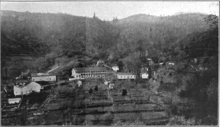
Kelsey Creek is a watercourse in Lake County, California, United States, that feeds Clear Lake from the south. Originally forest-covered, the watershed has been converted in the lower parts to farmland and for urban use. Higher up, the forests have been cleared, regrown, and cleared again. The northern part of the creek flows through a geothermal field that feeds power plants and hot springs. The wooded Cobb area in the higher part of the watershed was once home to resorts as early as the 1850s.

Cow Mountain is a ridge in the Mayacamas Mountains in Lake County, California, and Mendocino County, California. It is home to two large recreation areas. One is closed to off-road vehicles and the other is not. Erosion from the mountain, caused in part by human land use, contributes sediment and nutrients to Clear Lake.

Scotts Creek is a stream in Lake County, California, the largest tributary of Clear Lake. It rises to the south of Cow Mountain in the Mayacamas Mountains, then flows southeast towards Clear Lake, running through the fertile Scotts Valley and the seasonal Tule Lake before joining Middle Creek and flowing into the lake via Rodman Slough.
Mahnke Peak is a 3,652 feet (1,113 m) mountain in Mendocino County, California.
Pyramid Ridge is a 3,520–3,560 feet (1,070–1,090 m) mountain in Mendocino County, California.

Cold Creek is a river of Mendocino County, California, a tributary of East Fork Russian River. In the past it may have connected Clear Lake to the Russian River before this route was blocked by a large landslide and Clear Lake began to drain into the Sacramento River watershed.

The Blue Lakes are a string of two or three lakes in Lake County, California, set in a deep canyon. At one time they seem to have been in the Russian River watershed, but a recent geological upheaval cut them off from that basin and they now drain via Scotts Creek into Clear Lake in the Sacramento River basin. In the 19th and early 20th centuries there were several resorts around the lakes. Their waters have been highly altered by human activity and most of their native fish are lost, but they have a healthy population of largemouth bass.
Tule Lake is a seasonal lake in Lake County, California. It is named after the edible bullrushes, or tules, that used to surround the lake. These have been cleared and the lake partly drained to support agriculture, but it still floods every winter. In summer it is used for growing wild rice and grazing cattle. There have been proposals to restore the lake to its original wetlands condition.
Middle Creek is a creek that drains through Rodman Slough into Clear Lake in Lake County, California. It supplies 21% of the streamflow to Clear Lake. The watershed vegetation has been drastically modified by European settlers through sheep and cattle grazing, logging and farming in the valley floors. The creek once flowed through extensive wetlands at its mouth, but these were mainly drained to create farmland, apart from Rodman Slough on the west side. There are now projects to restore the drained land to its original condition.

Rivers and creeks in Lake County, California are listed below by river basin and alphabetically. Unless otherwise stated, the information is taken from the Geographic Names Information System maintained by the United States Geological Survey. Coordinates, elevations and lengths from this source are approximate.


