Eldridge | |
---|---|
Coordinates: 38°20′31″N122°30′43″W / 38.34194°N 122.51194°W Coordinates: 38°20′31″N122°30′43″W / 38.34194°N 122.51194°W | |
Country | United States |
State | California |
County | Sonoma |
Area | |
• Total | 0.652 sq mi (1.689 km2) |
• Land | 0.652 sq mi (1.689 km2) |
• Water | 0 sq mi (0 km2) 0% |
Elevation | 177 ft (54 m) |
Population (2010) | |
• Total | 1,233 |
• Density | 1,900/sq mi (730/km2) |
Time zone | UTC-8 (PST) |
• Summer (DST) | UTC-7 (PDT) |
ZIP code | 95431 |
Area code(s) | 707 |
FIPS code | 06-21894 |
GNIS feature ID | 1701268 |
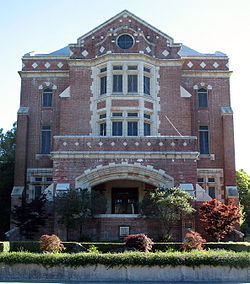
Eldridge is a census-designated place (CDP) in Sonoma County, California, United States. The population was 1,233 at the 2010 census. It is notably the home to the Sonoma Developmental Center, the largest facility serving the needs of persons with developmental disabilities in the state.
Eldridge is named for James Eldridge who owned part of the Rancho Cabeza de Santa Rosa land grant. [3]
According to the United States Census Bureau, the CDP has a total area of 0.7 square miles (1.8 km2), all of it land.
Historical population | |||
---|---|---|---|
Census | Pop. | %± | |
U.S. Decennial Census [4] |
The 2010 United States Census [5] reported that Eldridge had a population of 1,233. The population density was 1,891.1 inhabitants per square mile (730.2/km2). The racial makeup of Eldridge was 988 (80.1%) White, 10 (0.8%) African American, 3 (0.2%) Native American, 36 (2.9%) Asian, 6 (0.5%) Pacific Islander, 144 (11.7%) from other races, and 46 (3.7%) from two or more races. Hispanic or Latino of any race were 325 persons (26.4%).
The Census reported that 99.8% of the population lived in households and 0.2% lived in non-institutionalized group quarters.
There were 500 households, out of which 155 (31.0%) had children under the age of 18 living in them, 242 (48.4%) were opposite-sex married couples living together, 46 (9.2%) had a female householder with no husband present, 28 (5.6%) had a male householder with no wife present. There were 35 (7.0%) unmarried opposite-sex partnerships, and 5 (1.0%) same-sex married couples or partnerships. 137 households (27.4%) were made up of individuals, and 33 (6.6%) had someone living alone who was 65 years of age or older. The average household size was 2.46. There were 316 families (63.2% of all households); the average family size was 3.02.
The population was spread out, with 274 people (22.2%) under the age of 18, 109 people (8.8%) aged 18 to 24, 320 people (26.0%) aged 25 to 44, 394 people (32.0%) aged 45 to 64, and 136 people (11.0%) who were 65 years of age or older. The median age was 39.8 years. For every 100 females, there were 100.8 males. For every 100 females age 18 and over, there were 99.0 males.
There were 563 housing units at an average density of 863.5 per square mile (333.4/km2), of which 53.4% were owner-occupied and 46.6% were occupied by renters. The homeowner vacancy rate was 2.2%; the rental vacancy rate was 12.4%. 54.5% of the population lived in owner-occupied housing units and 45.3% lived in rental housing units.
As of the census [6] of 2000, there were 1,534 people, 521 households, and 321 families residing in the CDP. The population density was 2,403.1 inhabitants per square mile (927.8/km2). There were 551 housing units at an average density of 863.2 per square mile (333.3/km2). The racial makeup of the CDP was 85.92% White, 1.96% African American, 0.78% Native American, 2.80% Asian, 0.20% Pacific Islander, 4.04% from other races, and 4.30% from two or more races. Hispanic or Latino of any race were 13.95% of the population.
There were 521 households, out of which 35.9% had children under the age of 18 living with them, 46.3% were married couples living together, 10.4% had a female householder with no husband present, and 38.2% were non-families. 30.3% of all households were made up of individuals, and 5.8% had someone living alone who was 65 years of age or older. The average household size was 2.44 and the average family size was 3.10.
In the CDP, the population was spread out, with 22.7% under the age of 18, 6.3% from 18 to 24, 35.5% from 25 to 44, 29.1% from 45 to 64, and 6.3% who were 65 years of age or older. The median age was 38 years. For every 100 females, there were 99.7 males. For every 100 females age 18 and over, there were 94.4 males.
The median income for a household in the CDP was $52,656, and the median income for a family was $62,500. Males had a median income of $35,426 versus $34,886 for females. The per capita income for the CDP was $24,076. None of the families and 16.3% of the population were living below the poverty line, including no under eighteens and 11.8% of those over 64.
In the California State Legislature, Eldridge is in the 2nd Senate District , represented by Democrat Mike McGuire, and in the 4th Assembly District , represented by Democrat Cecilia Aguiar-Curry. [7]
In the United States House of Representatives, Eldridge is in California's 5th congressional district , represented by Democrat Mike Thompson. [8]
Diablo is a census-designated place (CDP) in Contra Costa County, California, United States. The population was 1,158 at the 2010 census. It is located 2.5 miles (4.0 km) east-northeast of Danville.
Bowles is a census-designated place (CDP) in Fresno County, California, United States. The population was 166 at the 2010 census, down from 182 at the 2000 census. Bowles is located 11 miles (18 km) south of downtown Fresno, at an elevation of 279 feet.
Easton is a census-designated place (CDP) in Fresno County, California, United States. The population was 2,083 at the 2010 census, up from 1,966 at the 2000 census. Easton is located 7.5 miles (12.1 km) south of downtown Fresno, at an elevation of 276 feet.
Raisin City is a census-designated place (CDP) in Fresno County, California, United States. The population was 380 at the 2010 census, up from 165 at the 2000 census. Raisin City is located 13 miles (21 km) south-southwest of downtown Fresno, at an elevation of 236 feet.
Riverdale is a census-designated place (CDP) in Fresno County, California, United States. The population was 3,153 at the 2010 census, up from 2,416 at the 2000 census. Riverdale is located 23 miles (37 km) south of Fresno, at an elevation of 223 ft (68 m).
Westhaven-Moonstone is a census-designated place (CDP) located in Humboldt County, California, United States. As of the 2010 census the population was 1,205, up from 1,044 at the 2000 census.
Mesa is a census-designated place (CDP) in Inyo County, California, United States. The population was 251 at the 2010 census, up from 214 at the 2000 census.
Wilkerson is a census-designated place (CDP) in Inyo County, California, United States. The population was 563 at the 2010 census, up from 562 at the 2000 census.
Tupman is a census-designated place (CDP) in Kern County, California, United States. Tupman is located 20 miles (32 km) west-southwest of Bakersfield, at an elevation of 331 feet (101 m). The population was 161 at the 2010 census, down from 227 at the 2000 census.
Weldon is a census-designated place (CDP) in Kern County, California, United States. It sits at the southeast tip of Lake Isabella. Weldon is located 9 miles (14 km) east-southeast of Wofford Heights, at an elevation of 2,654 feet (809 m). The population was 2,642 at the 2010 census, up from 2,387 at the 2000 census.
North El Monte is a census-designated place (CDP) in the San Gabriel Valley, in Los Angeles County, California, United States. The population was 3,723 at the 2010 census, up from 3,703 at the 2000 census.
West Rancho Dominguez, formerly known as West Compton, is an unincorporated census-designated place (CDP) located in southern Los Angeles County, California. Per the 2020 census, the population was 24,347. The community lies to the west of the city of Compton. The ZIP Codes encompassing the CDP area are 90220 & 90248.
Johnsville is a census-designated place (CDP) in Plumas County, California, United States. The population was 20 at the 2010 census, down from 21 at the 2000 census.
Keddie is a census-designated place in Plumas County, California, United States. The population was 66 at the 2010 census.
Lake Almanor Country Club is a census-designated place (CDP) in Plumas County, California, United States. The population was 419 at the 2010 census, down from 847 at the 2000 census. The ZIP code for the CDP is 96137.
Whitehawk is a census-designated place in Plumas County, California, United States. The population was 113 at the 2010 census, up from 96 at the 2000 census.
Lakeview is a census-designated place (CDP) in Riverside County, California, United States. The population was 2,104 at the 2010 census, up from 1,619 at the 2000 census. The community is named for nearby Mystic Lake.
Fruitdale is a district of San Jose, California, located in West San Jose, though some portions are still unincorporated as a census-designated place. The population of the CDP was 935 at the 2010 census.
Traver is a census-designated place (CDP) in Tulare County, California, United States. The population was 713 at the 2010 census, down from 732 at the 2000 census.
Stallion Springs is a census-designated place (CDP) in the Tehachapi Mountains, in Kern County, California, USA. The population was 2,488 at the 2010 census, up from 1,522 at the 2000 census. Stallion Springs is located in the greater Tehachapi Area.