
Sonoma County is a county located in the U.S. state of California. As of the 2020 United States Census, its population was 488,863. Its seat of government and largest city is Santa Rosa.

Glen Ellen is a census-designated place (CDP) in Sonoma Valley, Sonoma County, California, United States. The population was 784 at the 2010 census, down from 992 at the 2000 census. Glen Ellen is the location of Jack London State Historic Park, Sonoma Valley Regional Park, and a former home of Hunter S. Thompson.

Healdsburg is a city located in Sonoma County, California, United States. At the 2020 census, the city had a population of 11,340.

Sonoma Valley is a valley located in southeastern Sonoma County, California, in the North Bay region of the San Francisco Bay Area. Known as the birthplace of the California wine industry, the valley is home to some of the earliest vineyards and wineries in the state, some of which survived the phylloxera epidemic of the 1870s and the impact of prohibition in the early 20th century. Today, the valley's wines are promoted by the U.S. federal government's Sonoma Valley and Carneros AVAs.

The Petaluma River is a river in the California counties of Sonoma and Marin that becomes a tidal slough for most of its length. The headwaters are in the area southwest of Cotati. The flow is generally southward through Petaluma's old town, where the waterway becomes navigable, and then flows another 10 mi (16 km) through tidal marshes before emptying into the northwest corner of San Pablo Bay.

Dry Creek is a 43.0-mile-long (69.2 km) stream in the California counties of Sonoma and Mendocino. It is a tributary of the Russian River, with headwaters in Mendocino County.
Sonoma Creek is a 33.4-mile-long (53.8 km) stream in northern California. It is one of two principal drainages of southern Sonoma County, California, with headwaters rising in the rugged hills of Sugarloaf Ridge State Park and discharging to San Pablo Bay, the northern arm of San Francisco Bay. The watershed drained by Sonoma Creek is roughly equivalent to the wine region of Sonoma Valley, an area of about 170 square miles (440 km2). The State of California has designated the Sonoma Creek watershed as a “Critical Coastal Water Resource”. To the east of this generally rectangular watershed is the Napa River watershed, and to the west are the Petaluma River and Tolay Creek watersheds.

The Laguna de Santa Rosa is a 22-mile-long (35 km) wetland complex that drains a 254-square-mile (660 km2) watershed encompassing most of the Santa Rosa Plain in Sonoma County, California, United States.
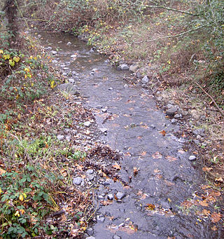
Carriger Creek is a stream Sonoma County, California. Southwest of the city of Sonoma, California, its name changes to Fowler Creek. This article covers both parts of the creek.

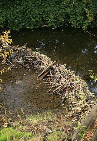
Calabazas Creek is a 5.5-mile-long (8.9 km) stream in the Sonoma Valley, California, United States, that rises in the southern Mayacamas Mountains and empties into Sonoma Creek near Glen Ellen.

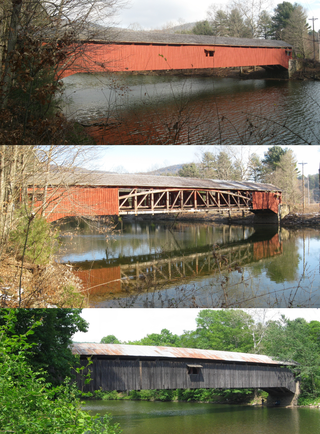
Old Blenheim Bridge was a wooden covered bridge that spanned Schoharie Creek in North Blenheim, New York, United States. With an open span of 210 feet (64 m), it had the second longest span of any surviving single-span covered bridge in the world. The 1862 Bridgeport Covered Bridge in Nevada County, California, currently undergoing repairs due to 1986 flooding is longer overall at 233 feet (71 m) but is argued to have a 208 feet (63 m) clear span. The bridge, opened in 1855, was also one of the oldest of its type in the United States. It was destroyed by flooding resulting from Tropical Storm Irene in 2011. Rebuilding of the bridge commenced in 2017 and was completed in 2018.

The Kreidersville Covered Bridge, which was built in 1839, is the last remaining covered bridge in Northampton County, Pennsylvania.
Adobe Creek is a southward-flowing stream in Sonoma County, California, United States, which flows past the historic Rancho Petaluma Adobe on the creek's 7.5-mile (12.1 km) course to its confluence with the Petaluma River. It has also been called Casa Grande Creek.

The Riverside Avenue Bridge is the only cast-iron bridge in Connecticut and one of a small number still in use in the United States. It carries Riverside Avenue over the New Haven Line railroad tracks in the Riverside section of Greenwich, Connecticut. The bridge was part of an earlier span built in 1871 over the Housatonic River by the New York and New Haven Railroad, and when that bridge was replaced, part of it was erected in Riverside in 1895. It was placed on the National Register of Historic Places in 1977.
The Hillsgrove Covered Bridge is a Burr arch truss covered bridge over Loyalsock Creek in Hillsgrove Township, Sullivan County, in the U.S. state of Pennsylvania. It was built c. 1850 and is 186 feet (56.7 m) long. In 1973, it became the first covered bridge in the county to be placed on the National Register of Historic Places (NRHP). The bridge is named for the township and nearby unincorporated village of Hillsgrove, and is also known as Rinkers Covered Bridge for an adjoining farm.

Wiss, Janney, Elstner Associates, Inc. (WJE) is an American corporation of architects, engineers, and materials scientists specializing in the investigation, analysis, testing, and design of repairs for historic and contemporary buildings and structures. Founded in 1956, WJE is headquartered in Northbrook, Illinois, and has over 600 professionals in twenty offices across the United States. WJE personnel are specialized in architectural, structural, and civil engineering; materials conservation, chemistry and petrography, and testing and instrumentation.

Watson School is a Sonoma County Regional Parks Department historic park, covering approximately 0.75 acres (0.30 ha), located about 2 miles (3.2 km) east of Bodega, California, on the south side of the road, at 15000 Bodega Highway in Sonoma County, California, United States. It was listed on the National Register of Historic Places in 1978.
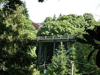
The North Queen Anne Drive Bridge is a deck arch bridge that spans Seattle's Wolf Creek. The 238 ft (73 m) long steel and concrete structure was built in 1936 to replace the previous wood-constructed crossing. It serves as a connection between the Queen Anne neighborhood and the George Washington Memorial Bridge that carries State Route 99. The arch is unusually high and uses a minimal number of supporting members. It was designated a city landmark on December 28, 1981, because of its unique engineering style.

Bridge in Washington Township, also known as Kralltown Road Bridge, was a double-intersection Pratt truss bridge spanning Bermudian Creek near Kralltown, Washington Township, York County, Pennsylvania. The bridge was built in 1884 by the Wrought Iron Bridge Company and measured 153 feet (47 m) in overall length.

Glen Hope Covered Bridge is a historic wooden covered bridge located in Elk Township, Chester County, Pennsylvania. It is a 65-foot-long (20 m) Burr truss bridge, constructed in 1889. It has vertical planking and eave-level window openings. It crosses Little Elk Creek.


