Five Creek

Last updated
Five Creek
FiveCreekPICT2916.jpg
Five Creek north of the golf course
Relief map of California.png
Red pog.svg
Location of the mouth of Five Creek in California
Location
Country United States
State California
Region Sonoma County
City Rohnert Park, California
Physical characteristics
Source 
 - location Rohnert Park, California
Mouth Laguna de Santa Rosa
 - location
west of Rohnert Park, California
 - coordinates
38°21′8″N122°44′24″W / 38.35222°N 122.74000°W / 38.35222; -122.74000 Coordinates: 38°21′8″N122°44′24″W / 38.35222°N 122.74000°W / 38.35222; -122.74000 [1]
 - elevation
85 ft (26 m)

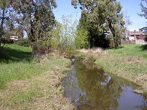
Five Creek is a westward flowing stream that rises in the city of Rohnert Park, California, United States and discharges to the Laguna de Santa Rosa. [1] The creek is channelized as it flows through the city and runs in an artificially rectilinear fashion. [2] Considered waters of the United States as a jurisdictional matter, Five Creek has potential habitat for the California red-legged frog and the Western pond turtle. [3]

Rohnert Park, California City in California in the United States

Rohnert Park is a city in Sonoma County, California, United States, located approximately 50 miles (80 km) north of San Francisco. The population at the 2010 United States Census was 40,971. It is an early planned city and is the sister city of Hashimoto in Japan. Sonoma State University, part of the California State University system, is located nearby.

Laguna de Santa Rosa wetland in Sonoma County, California, USA

The Laguna de Santa Rosa is a 22-mile-long (35 km) wetland complex that drains a 254-square-mile (660 km2) watershed encompassing most of the Santa Rosa Plain in Sonoma County, California, United States.

California red-legged frog species of amphibian

The California red-legged frog is a species of frog found in California (USA) and northern Baja California (Mexico). It was formerly considered a subspecies of the northern red-legged frog. The frog is an IUCN vulnerable species, and a federally listed threatened species of the United States, and is protected by law.

Contents

The name probably originated as a misreading of "Fire Creek," the name found on older maps.

Course

The route of Five Creek has been obscured by the development of Rohnert Park. A 1916 United States Geological Survey topographic map shows an unnamed westward-flowing creek circling north of Wilfred like Five Creek does today. At that time, the creek's headwaters lay in the Sonoma Mountains just north of Crane Creek. The Geographic Names Information System (GNIS) gives Five Creek's source coordinates as 38°21′19″N122°41′22″W / 38.3552778°N 122.6894444°W / 38.3552778; -122.6894444 , [4] currently a channel on the east edge of Eagle Park. However, satellite photos [5] show this channel connecting to Hinebaugh Creek north of San Mateo Court. A recent topographic map [1] shows Five Creek emerging near the corner of Golf Course Drive and Country Club Drive, its former headwaters having been diverted to Crane Creek.

United States Geological Survey Scientific agency of the United States government

The United States Geological Survey is a scientific agency of the United States government. The scientists of the USGS study the landscape of the United States, its natural resources, and the natural hazards that threaten it. The organization has four major science disciplines, concerning biology, geography, geology, and hydrology. The USGS is a fact-finding research organization with no regulatory responsibility.

Sonoma Mountains mountain range in California

The Sonoma Mountains are a northwest-southeast trending mountain range of the Inner Coast Ranges in the California Coast Ranges System, located in Sonoma County, Northern California.

Crane Creek (California) stream in Sonoma County, California

Crane Creek is a stream in Sonoma County, California, United States which rises in the northern Sonoma Mountains. This watercourse flows through Crane Canyon and the Crane Creek Regional Park situated on the northwestern flank of Sonoma Mountain. Crane Creek forms a confluence with Hinebaugh Creek in the city of Rohnert Park; thereafter, the channelized Hinebaugh Creek flows westerly to discharge to the Laguna de Santa Rosa. Hiking access to the upper Crane Creek reaches is from Roberts Road off Petaluma Hill Road.

From Golf Course Drive, Five Creek flows northwest, paralleling Country Club Drive to Fairway Drive. It crosses the golf course, emerging near the end of Fauna Avenue. North of the city limits, it turns abruptly westward and flows under U.S. Route 101 at the Santa Rosa Avenue interchange. West of U.S. Route 101, the channel turns to the southwest, crossing under Millbrae Avenue, Whistler Avenue, Wilfred Avenue, and Rohnert Park Expressway before entering the Laguna de Santa Rosa just east of Stony Point Road.

U.S. Route 101 highway in the United States

U.S. Route 101, or U.S. Highway 101 (US 101) is a north–south United States Numbered Highway that runs through the states of California, Oregon, and Washington, on the West Coast of the United States. It is also known as El Camino Real where its route along the southern and central California coast approximates the old trail which linked the Spanish missions, pueblos, and presidios. It merges at some points with California State Route 1 (SR 1).

The GNIS gives the mouth coordinates of Five Creek as 38°21′00″N122°43′56″W / 38.3499144°N 122.7322104°W / 38.3499144; -122.7322104 . [4] However, satellite images [6] and United States Geological Survey topographic maps, [1] show Hinebaugh Creek entering the Laguna at those coordinates. The Five Creek confluence lies about 0.5 mi (0.8 km) further west.

See also

Copeland Creek (California) stream in Sonoma County, California

Copeland Creek is a 9.0-mile-long (14.5 km) perennial stream that rises on Sonoma Mountain in Sonoma County, California.

Related Research Articles

South Santiam River river in the United States of America

The South Santiam River is a tributary of the Santiam River, about 69 miles (111 km) long, in western Oregon in the United States. It drains an area of the Cascade Range into the Willamette Valley east of Corvallis.

The Cotati-Rohnert Park Unified School District (CRPUSD) is a school district in Sonoma County, California.

Matanzas Creek stream in California

Matanzas Creek is an 11.4-mile-long (18.3 km) year-round stream in Sonoma County, California, United States, a tributary of Santa Rosa Creek.

Santa Rosa Creek stream in California

Santa Rosa Creek is a 22-mile-long (35 km) stream in Sonoma County, California, which rises on Hood Mountain and discharges to the Laguna de Santa Rosa by way of the Santa Rosa Flood Control Channel. This article covers both the creek and the channel.

Spring Creek (Sonoma County, California) stream in Sonoma County, California

Spring Creek, in Sonoma County, California, is a 6.0-mile-long (9.7 km) stream that rises in the northern part of the Sonoma Mountains within Annadel State Park, draining the western slopes of Taylor Mountain and feeding into Matanzas Creek below the Matanzas Creek Reservoir.

Washoe Creek perennial stream in California

Washoe Creek is a perennial stream located in Sonoma County, California. It is about 2 mi (3 km) long and discharges to the Laguna de Santa Rosa.

Mark West Creek stream in California

Mark West Creek is a 29.9-mile-long (48.1 km) stream that rises in the Mayacamas Mountains of Sonoma County, California, United States. Tributaries of Mark West Creek include Porter Creek and Hummingbird Creek, both of which originate in the same mountain range. Discharge waters of Mark West Creek reach the Russian River after a confluence with the Laguna de Santa Rosa. The Community Clean Water Institute has developed a program for monitoring pollutants in Mark West Creek.

Hinebaugh Creek stream in California

Hinebaugh Creek is a westward-flowing stream in western Sonoma County within the Laguna de Santa Rosa watershed. As this watercourse proceeds westerly through the city of Rohnert Park, it has largely been channelized and courses in an artificially straight alignment. Considered waters of the United States as a jurisdictional matter, Hinebaugh Creek is potential habitat for the California red-legged frog and the Western pond turtle. The dominant riparian vegetation is Himalayan blackberry and willow.

Windsor Creek stream in California

Windsor Creek is an 8.8-mile-long (14.2 km) southward-flowing stream in Sonoma County, California, United States, which rises near Healdsburg, California, and feeds into Mark West Creek west of the Sonoma County Airport. Its waters reach the Pacific Ocean by way of the Russian River.

Oso Creek river in the United States of America

Oso Creek is an approximately 13.5-mile (21.7 km) tributary of Arroyo Trabuco in southern Orange County in the U.S. state of California. Draining about 20 square miles (52 km2) in a region north of the San Joaquin Hills and south of the Santa Ana Mountains, the creek is Trabuco Creek's largest tributary, and is part of the San Juan Creek drainage basin. Beginning in the foothills of the Santa Ana Mountains near the city of Mission Viejo, the creek is dammed twice to form Upper Oso Reservoir and Lake Mission Viejo. The creek is channelized and polluted along much of its length.

Crystal Springs Creek

Crystal Springs Creek, a 2.7-mile (4.3 km) tributary of Johnson Creek, flows entirely within the city of Portland in the U.S. state of Oregon. The stream rises from springs near the Reed College campus in the southeastern part of the city and runs generally southwest to meet Johnson Creek in the Portland neighborhood of Sellwood.

Baldwin Hills (mountain range)

The Baldwin Hills are a low mountain range surrounded by and rising above the Los Angeles Basin plain in central Los Angeles County, California. The Pacific Ocean is to the west, the Santa Monica Mountains to the north, Downtown Los Angeles to the northeast, and the Palos Verdes Hills to the south - with all easily viewed from the Baldwin Hills.

Bell Creek (Southern California) river in the United States of America

Bell Creek is a 10-mile-long (16 km) tributary of the Los Angeles River, in the Simi Hills of Ventura County and the San Fernando Valley of Los Angeles County and City, in Southern California.

Arroyo Calabasas is a 7.0-mile-long (11.3 km) tributary of the Los Angeles River, in the southwestern San Fernando Valley area of Los Angeles County in California.

Agua Chinon Creek or Agua Chinon Wash is an urban stream in the city of Irvine, Orange County, California. The creek flows southwest from its headwaters in the foothills of the Santa Ana Mountains for about 8 miles (13 km) to join San Diego Creek near the Verizon Amphitheatre. The creek drains a total watershed area of 7,049 acres (2,853 ha).

References

  1. 1 2 3 4 Cotati (Map). 7.5 minute quadrangle. U.S. Geological Survey. 2000.
  2. Hogan, C. Michael; Marc Papineau; Ballard George; City of Rohnert Park; California and the State of California Environmental Clearinghouse; et al. (March 9, 1990). Environmental Impact Report for the City of Rohnert Park General Plan (Technical report). Earth Metrics, Inc. Report number 10351.
  3. "A Biological Assessment for the UD LLC and Vast Oak Properties". Rohnert Park, California. 2003.[ permanent dead link ]
  4. 1 2 U.S. Geological Survey Geographic Names Information System: Five Creek
  5. "Google Maps" . Retrieved 2007-12-31.
  6. "Google Maps" . Retrieved 2007-12-31.